By Deeg
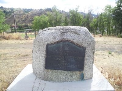
Old Mission Indian Cemetery Marker
| On Eels Road near Mount Stuart Road, on the right when traveling east. |
| On East Woodin Avenue east of North Columbia Street, on the right when traveling east. |
| On U.S. 97A 1 mile north of North Lakeshore Drive, on the left when traveling north. |
| On U.S. 2 at 9th Street, on the left when traveling west on U.S. 2. |
| Near U.S. 2 at Coulter Creek Road, on the right when traveling west. |
| On Golden West Drive south of Stehekin Valley Road, on the right when traveling south. |
| On South Wenatchee Avenue at Kittitas Street, on the right when traveling north on South Wenatchee Avenue. |
| On Orondo Avenue at Methow Street, on the left when traveling east on Orondo Avenue. |
| On South Mission Street (Washington Route 285) north of Yakima Street, on the right when traveling north. |
| On Locust Grove Camp Ground Road at Delaware Ave S on Locust Grove Camp Ground Road. |
| On Locust Grove Camp Ground Road at Delaware Ave S on Locust Grove Camp Ground Road. |
| On Locust Grove Camp Ground Road at Delaware Ave S, on the left when traveling south on Locust Grove Camp Ground Road. |
| Near Washington 21 east of Vulcan Mountain Road. |
| On Kettle River Road 0.1 miles south of Custom Road, on the right when traveling north. |
| Near Republic Cemetery Rd 0.1 miles north of North Klondike Road, on the left when traveling north. |
| Near Brewster Airport Road. |
| On Chesaw Road (County Road 9480) south of Hill Street, on the right when traveling south. |
| On Chesaw Road at Easy Way Road, on the left when traveling south on Chesaw Road. |
| On North Main Street south of Silver Street, on the left when traveling north. |
| On North Main Street at Silver Street, on the right when traveling south on North Main Street. |
| On Broadway Street at Lottie Ave, on the left when traveling west on Broadway Street. |
| On Conconully Road, on the right when traveling north. |
| On Crown Point Road 0.9 miles east of Barry Rex Road, on the right when traveling east. |
| On Ellisforde Church Road. |
| On Old Highway 97 at Chillowist Road, on the right when traveling south on Old Highway 97. |
| On Methow Highway (State Highway 153) at Osborn Ave, on the right when traveling north on Methow Highway. |
| On 9 Mile Road (County Route 4777), on the right when traveling west. |
| On County Highway 4777 north of Molson Ave, on the left when traveling north. |
| On Molson Road (County Route 4777), on the right when traveling north. |
| On 2nd Avenue North at Pine Street, on the left when traveling north on 2nd Avenue North. |
| On Queen Street at 3rd Ave S, on the right when traveling east on Queen Street. |
| On 3rd Avenue North at Oak Street, on the right when traveling south on 3rd Avenue North. |
| On Salmon Creek Road at Ruby Grde, on the left when traveling north on Salmon Creek Road. |
| On U.S. 97 3.7 miles south of Osprey Drive (State Highway 20), on the right when traveling south. |
| On Washington State Highway 20 (Washington Route 20) west of Old US Highway 97, on the right when traveling west. |
| On Molson Road (County Route 4777) near Pioneer Road, on the right when traveling north. |
| On Washington 155 east of U.S. 97. |
| On 9 Mile Road north of Chesaw Road, on the left when traveling north. |
| On U.S. 97 south of George Ehlers Road, on the right when traveling north. |
| On Chesaw Road (County Road 9480) east of Havillah, on the left when traveling east. |
| Near Lakeshore Drive 0.1 miles east of Commercial Avenue, on the right when traveling east. |
| Near Commercial Avenue north of Lakeshore Drive, on the right when traveling north. |
| On Lakeshore Drive west of S. Dawson Street, on the left when traveling west. |
| Near Commercial Avenue north of Lakeshore Drive, on the right when traveling north. |
| Near Commercial Avenue south of South Dawson, on the right when traveling north. |
| On U.S. 97 0.4 miles south of Methow Valley Highway (State Highway 153), on the right when traveling north. |
| Near Commercial Avenue south of South Dawson, on the right when traveling north. |
| On N Main Street 1 mile north of U.S. 97, on the right when traveling north. |
| On Conconully Road 1 mile south of Salmon Creek Road, on the right when traveling north. |
| On McLaughlin Canyon Road, on the right when traveling south. |
| On Methow Valley Highway (Washington Route 153) 0.5 miles south of Lower Beaver Creek Road, on the right when traveling north. |
| On Methow Valley Highway (Washington Route 153) 0.5 miles south of Lower Beaver Creek Road, on the right when traveling north. |
| On Toroda Creek Road (County Highway 9495) 0.5 miles south of Oroville-Toroda Creek Road (County Highway 9480), on the left when traveling south. |
| On Washington Route 20 east of Toroda Creek Road (County Road 9495), on the left when traveling west. |
| On Toroda Creek Road, on the right when traveling south. |
| On Riverside Avenue at Bridge Street on Riverside Avenue. |
| On National Forest Development Road 1137. |
| On International Selkirk Loop (State Road 31) south of Box Canyon Dam Road. |
| On Box Canyon Dam Road east of International Selkirk Loop ( Highway 31), on the right when traveling east. |
| On International Selkirk Loop (State Road 31) south of Box Canyon Dam Road. |
| Near International Selkirk Loop (Washington Route 31) 0.6 miles south of Box Canyon Dam Road, on the left when traveling south. |
| Near International Selkirk Loop (Washington Route 31) 0.6 miles south of Box Canyon Dam Road, on the left when traveling south. |
| Near Boundary Dam Access Road. |
| On Boundary Dam Access Road. |
| On U.S. 2 at South Washington Avenue, on the right when traveling west on U.S. 2. |
| On 4th Street at S Scott Ave, on the right when traveling east on 4th Street. |
| On Flowery Trail Road 0.1 miles north of Cottonwood Creek Road, on the left when traveling north. |
| On Flowery Trail Road (at milepost 2,920), 0.1 miles Cottonwood Creek Road, on the left when traveling north. |
| On Flowery Trail Road 0.1 miles north of Cottonwood Creek Road, on the left when traveling north. |
| On Flowery Trail Road 0.1 miles north of Cottonwood Creek Road, on the left when traveling east. |
| On South Oak Street at E Birch Ave, on the right when traveling north on South Oak Street. |
| On Aladdin Road 0.1 miles north of Knapp Road, on the right when traveling north. |
| On Aladdin Road at Douglas Falls Road, on the left when traveling north on Aladdin Road. |
| On State Highway 231 north of Ford-Wellpinit Road, on the right when traveling north. |
| On St Paul Mission Road 0.5 miles east of Sherman Pass Scenic Byway ( Highway 20). |
| On Saint Paul Mission Road east of Sherman Pass Scenic Bypass (U.S. 395), on the right when traveling north. |
| On St Paul Mission Rd 0.5 miles east of Sherman Pass Scenic Byway ( Highway 20). |
| On Saint Paul Mission Road, on the right when traveling north. |
