315 entries match your criteria. The first 100 are listed. ⊳
Vermont Division for Historic Preservation Markers
More than 340 green and gold markers placed by the Vermont Division for Historic Preservation and its predecessors (such as the Vermont Historic Sites Commission and the Vermont Board of Historic Sites) that are associated with an event, person, or architecture significant to local Vermont or national history.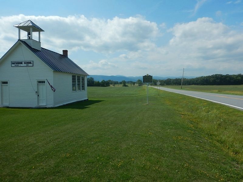
By Kevin Craft, August 28, 2016
Wideview of Hathorne School Marker
1 ► Vermont, Addison County, Bridport — Hathorne School — Bridport District Schoolhouse #1 —  |
| On Vermont Route 125 at Basin Harbor Road, on the left when traveling west on Vermont Route 125. | |||
| 2 ► Vermont, Addison County, Cornwall, Bread Loaf — William Slade / The Gag Rule — 1786–1857 / 1836–1844 — |
| On Seth Warner Memorial Highway, on the right when traveling north. | |||
| 3 ► Vermont, Addison County, Ferrisburgh — "Rokeby" — Home of Rowland E. Robinson Writer of Vermont Folklore — |
| On U.S. 7, on the right when traveling north. | |||
| 4 ► Vermont, Addison County, Ferrisburgh — The Great Convention — |
| On U.S. 7 at Middlebrook Road on U.S. 7. | |||
| 5 ► Vermont, Addison County, Granville — The Corner School — Granville School District #10 — |
| On Post Office Hill north of Route 100, on the left when traveling north. | |||
| 6 ► Vermont, Addison County, Middlebury — Birthplace of Ray Fisher — |
| On Court Street (U.S. 7) at Creek Road, on the right when traveling south on Court Street. | |||
| 7 ► Vermont, Addison County, Middlebury — Court Square — |
| Near Court Square (Route 7) west of Washington Street, on the right when traveling south. | |||
| 8 ► Vermont, Addison County, Middlebury — Emma Willard — Pioneer educator gave women first college training here — |
| On South Main Street (Vermont Route 30) 0.1 miles north of Porter Field Road, on the right when traveling north. | |||
| 9 ► Vermont, Addison County, Middlebury — Frederick Douglass Launched The One Hundred Conventions — |
| On Court Square (U.S. 7) at South Pleasant Street, on the left when traveling west on Court Square. | |||
| 10 ► Vermont, Addison County, Middlebury — John Deere — Inventor of "The Plow that Broke the Plains" — |
| On Main Street 0.1 miles south of Mill Street, on the right when traveling south. | |||
| 11 ► Vermont, Addison County, Orwell — Mt. Independence Military Road — Route to Hubbardton, 1777 |
| On Vermont Route 22A at Main St (County Route 73), on the right when traveling south on Vermont Route 22A. Reported permanently removed. | |||
| 12 ► Vermont, Addison County, Orwell — Mt. Independence Military Road — Route to Hubbardton - 1777 — |
| On Vermont Route 22A at Route 73, on the right when traveling south on Vermont Route 22A. | |||
| 13 ► Vermont, Addison County, Ripton — Robert Frost — 1874 - 1963 — |
| On Vermont Route 125 just west of Frost Road, on the left when traveling east. | |||
| 14 ► Vermont, Addison County, Shoreham — Levi P. Morton — Statesman and Banker lived early years in Vermont — |
| On School Road 0.1 miles south of Main Street. | |||
| 15 ► Vermont, Addison County, Shoreham — Shoreham Covered Railroad Bridge — |
| Near Shoreham Depot Road. | |||
| 16 ► Vermont, Addison County, Vergennes — Macdonough Shipyard — |
| Near Macdonough Drive 0.3 miles west of Main Street ( Route 22A). | |||
| 17 ► Vermont, Addison County, Vergennes — Stephen Bates — Vermont’s Earliest Known Black Sheriff and Chief of Police — |
| On West Main Street (Vermont Route 22A) at Park Street, on the left when traveling north on West Main Street. | |||
| 18 ► Vermont, Addison County, Weybridge, Bread Loaf — Silas Wright — 1795-1847 — |
| On Weybridge Road (Vermont Route 23) at James Road, on the right when traveling south on Weybridge Road. | |||
| 19 ► Vermont, Addison County, Weybridge, Bread Loaf — The U.S. Government Morgan Horse Farm — |
| Near Battell Drive. | |||
| 20 ► Vermont, Bennington County, Arlington — Norman Rockwell — 1894-1978 — |
| On River Road at Covered Bridge Road, on the right when traveling east on River Road. | |||
| 21 ► Vermont, Bennington County, Arlington — State Seal Pine Tree — |
| On Vermont Route 313 0.8 miles west of Ethan Allen Highway (Alternate Route 7A), on the right when traveling west. | |||
| 22 ► Vermont, Bennington County, Arlington — Chittenden Home — |
| On Main Street (Alternate Vermont Route 7) at East Arlington Road, on the right when traveling north on Main Street. | |||
| 23 ► Vermont, Bennington County, Arlington — Dorothy Canfield Fisher — (1879-1958) — |
| On Main Street (Alternate Vermont Route 7) 0.1 miles south of Route 313, on the right when traveling north. | |||
| 24 ► Vermont, Bennington County, Bennington — Vermont is a State I Love — |
| On Depot Street near River Street, on the left when traveling north. | |||
| 25 ► Vermont, Bennington County, Bennington, North Bennington — Park-McCullough House — |
| On Park Street at West Street on Park Street. | |||
| 26 ► Vermont, Bennington County, Bennington, Old Bennington — Bennington Battle Monument — |
| On Monument Avenue at Main Street ( Route 9), on the left when traveling north on Monument Avenue. | |||
| 27 ► Vermont, Bennington County, Bennington, Old Bennington — Seth Warner — Revolutionary War Hero — |
| On Monument Circle at Monument Avenue, on the left when traveling east on Monument Circle. | |||
| 28 ► Vermont, Bennington County, Bennington, Old Bennington — The "Corkscrew" Railroad — |
| On Main Street (Vermont Route 9), on the right when traveling east. | |||
| 29 ► Vermont, Bennington County, Bennington, Old Bennington — Vermont — Molly Stark Trail and Historic Old Bennington — |
| Near Main Street (Vermont Route 9) 0.1 miles west of Convent Avenue. | |||
| 30 ► Vermont, Bennington County, Bennington, Vermont Veterans' Home — Vermont Veterans' Home — |
| Near North Street (U.S. 7) at Depot Street, on the right when traveling west. | |||
| 31 ► Vermont, Bennington County, Dorset — Dorset — Here New Hampshire Grants First Voted Independence — |
| On Vermont Route 30 at Church Street, on the right when traveling north on Vermont Route 30. | |||
| 32 ► Vermont, Bennington County, Dorset — Fenton Pottery Site — 1801-1810 — |
| On Dorset Hollow Road at Kirby Hollow Road, on the right when traveling south on Dorset Hollow Road. | |||
| 33 ► Vermont, Bennington County, Dorset — First Marble Quarry — Oldest Quarry in U.S., 1785 — |
| On Vermont Route 30 at Kelly Road, on the right when traveling north on Vermont Route 30. | |||
| 34 ► Vermont, Bennington County, Dorset — Harmon's Mint — East Rupert — |
| On Vermont Route 30, on the right when traveling north. | |||
| 35 ► Vermont, Bennington County, Dorset, East Dorset — Birthplace of William Griffith Wilson — 1895-1971 — Co-founder of Alcoholics Anonymous — |
| On Mad Tom Road at Village Street, on the right when traveling north on Mad Tom Road. | |||
| 36 ► Vermont, Bennington County, Manchester, Manchester Center — Fred Nicklewhite — 1892-1996 — |
| On Main Street (Vermont Route 7A) 0.6 miles south of Depot Street ( Route 30), on the right when traveling south. | |||
| 37 ► Vermont, Bennington County, Manchester, Manchester Center — Lincoln’s "Hildene" — Summer Home of Son of Civil War President — |
| On Hildene Road, on the right when traveling north. | |||
| 38 ► Vermont, Bennington County, Manchester, Manchester Center — The Revolutionary War — |
| On Main Street (Alternate Vermont Route 7) at Union Street, on the right when traveling north on Main Street. | |||
| 39 ► Vermont, Bennington County, Manchester, Manchester Center — The Southern Vermont Arts Center — |
| On Southern Vermont Art Center Drive 0.2 miles west of West Road, on the right when traveling west. | |||
| 40 ► Vermont, Bennington County, Pawlet, Dorset — The Dorset Field Club — Oldest Continually Operated Golf Course in the United States — |
| On Vermont Route 30, on the right when traveling south. | |||
| 41 ► Vermont, Bennington County, Pownal, North Pownal — Early Eighteenth Century Settlement — |
| On Vermont Route 346 0.1 miles west of Indian Massacre Road, on the right when traveling east. | |||
| 42 ► Vermont, Bennington County, Pownal, North Pownal — Pownal — Two Presidents Taught Here — |
| On Vermont Route 346 at North Pownal Road, on the right when traveling north on Vermont Route 346. | |||
| 43 ► Vermont, Bennington County, Pownal, Pownal Center — Vermont U.S. 7 follows historic route — |
| On Center Street south of N Pownal Road, on the left when traveling south. | |||
| 44 ► Vermont, Bennington County, Rupert, West Rupert — Lt. Col. Robert Cochran — Revolutionary Hero Settled Here, 1769 — |
| On Vermont Route 153. | |||
| 45 ► Vermont, Bennington County, Shaftsbury — Governor Jonas Galusha Homestead — |
| On Ethan Allen Highway (Vermont Route 7A) 0.5 miles north of Tunic Road, on the right when traveling south. | |||
| 46 ► Vermont, Bennington County, Shaftsbury — Shaftsbury — The Birthplace, 1805, of Jacob Merritt Howard — |
| On Ethan Allen Highway (Alternate Vermont Route 7A) at Tunic Road, on the right when traveling north on Ethan Allen Highway. | |||
| 47 ► Vermont, Bennington County, Shaftsbury, South Shaftsbury — The Old Mill — |
| On Vermont Route 7A north of Route 67, on the left when traveling north. | |||
| 48 ► Vermont, Bennington County, Sunderland — Sunderland — Allen families lived here — |
| On Alternate Vermont Route 7 0.1 miles south of Hill Farm Road, on the right when traveling south. | |||
| 49 ► Vermont, Bennington County, Sunderland, Arlington — Chiselville — |
| On Sunderland Hill Road, on the right when traveling north. | |||
| 50 ► Vermont, Bennington County, Winhall, South Londonderry — Scott Nearing / Helen Knothe Nearing — (August 6, 1883 - August 24, 1983) / (February 23, 1904 - September 17, 1995) — |
| On Upper Taylor Hill Road at Stone Cabin Road, on the left when traveling south on Upper Taylor Hill Road. | |||
| 51 ► Vermont, Caledonia County, Barnet — Ben's Mill — |
| On West Barnet Road, on the left. | |||
| 52 ► Vermont, Caledonia County, Barnet — Henry Stevens / Henry Stevens, Jr. — |
| On U.S. 5, on the right when traveling north. | |||
| 53 ► Vermont, Caledonia County, Barnet — Moore Round Barn — |
| On Vermont Route 5, on the left when traveling south. | |||
| 54 ► Vermont, Caledonia County, Barnet — The Comerford Development at Fifteen Mile Falls — |
| On Interstate 91 at milepost 121.8, on the right when traveling north. | |||
| 55 ► Vermont, Caledonia County, Danville — Greenbank's Hollow — A Forgotten Village — |
| On Greenbanks Hollow Road at Brook Road, on the right when traveling south on Greenbanks Hollow Road. | |||
| 56 ► Vermont, Caledonia County, Danville — Thaddeus Stevens — |
| On Theodore Roosevelt Hwy (U.S. 2) at Peacham Road, on the right when traveling east on Theodore Roosevelt Hwy. | |||
| 57 ► Vermont, Caledonia County, East Burke — Mountain View Farm — |
| On Darling Hill Road at East Darling Hill Road, on the right when traveling south on Darling Hill Road. | |||
| 58 ► Vermont, Caledonia County, Hardwick — Camp Wapanacki — |
| On Hines Road, on the left when traveling south. | |||
| 59 ► Vermont, Caledonia County, Lyndon, Lyndonville — Site of Lyndon's First Town Meeting — July 4, 1791 — |
| On Vail Drive, on the left when traveling north. | |||
| 60 ► Vermont, Caledonia County, Lyndonville — Theodore N. Vail — Pioneer in Creating the Telephone Industry — |
| On College Road 1 mile Center Street ( Route 122), on the left when traveling south. | |||
| 61 ► Vermont, Caledonia County, Peacham — Caledonia County Grammar School — |
| On Bayley-Hazen Road 0.1 miles south of Church Street, on the right when traveling south. | |||
| 62 ► Vermont, Caledonia County, Ryegate — James Whitehill Stone House — 1808 — |
| On Peacham Road at Stonehouse Road, on the right when traveling south on Peacham Road. | |||
| 63 ► Vermont, Caledonia County, St. Johnsbury — Northeastern Speedway — |
| On Vermont Route 18 just east of Slate Ledge Road. | |||
| 64 ► Vermont, Caledonia County, St. Johnsbury — First American Platform Scale |
| On Portland Street (U.S. 2) at Spaulding Road, on the right when traveling east on Portland Street. Reported permanently removed. | |||
| 65 ► Vermont, Caledonia County, St. Johnsbury — First American Platform Scale — |
| On Western Avenue (U.S. 2) at Mount Vernon Street, on the right when traveling east on Western Avenue. | |||
| 66 ► Vermont, Caledonia County, St. Johnsbury — St. Johnsbury Trade School — |
| On Western Avenue (U.S. 2) 0.3 miles west of Main Street, on the left when traveling west. | |||
| 67 ► Vermont, Caledonia County, Wheelock, Lyndonville — Wheelock — The Dartmouth College Land Grant — |
| On Vermont Route 122 at Sutton Road, on the right when traveling north on Vermont Route 122. | |||
| 68 ► Vermont, Chittenden County, Bolton, Colbyville — The Long Trail — |
| On Vermont Route 2, on the left when traveling east. | |||
| 69 ► Vermont, Chittenden County, Burlington — 2nd Vermont Volunteer Infantry Regiment — |
| Near Park Street (Vermont Route 127) at Sherman Street, on the right when traveling south. | |||
| 70 ► Vermont, Chittenden County, Burlington — Battery Park — Scene of British Attack in War of 1812 — |
| Near Battery Street. | |||
| 71 ► Vermont, Chittenden County, Burlington — Captain John Lonergan — 1837 - 1902 — Hero of Gettysburg — |
| On St. Paul Street north of Main Street (U.S. 2), on the right when traveling north. | |||
| 72 ► Vermont, Chittenden County, Burlington — First International Ice Hockey Game — Premier Match International De Hockey Sur Glace — |
| On Lake Street 0.2 miles north of College Street, on the left when traveling north. | |||
| 73 ► Vermont, Chittenden County, Burlington — Little Italy — |
| On Battery Street at Cherry Street, on the right when traveling south on Battery Street. | |||
| 74 ► Vermont, Chittenden County, Burlington — Revolutionary War Patriots — |
| Near Park Street south of Sherman Street, on the right when traveling south. | |||
| 75 ► Vermont, Chittenden County, Burlington, Centennial — Burial Place of General Ethan Allen — Born 1738 – Died 1789 — |
| Near Colchester Avenue 0.3 miles east of East Avenue. | |||
| 76 ► Vermont, Chittenden County, Burlington, Centennial — Centennial Field — |
| On University Road 0.1 miles south of Colchester Avenue, on the right when traveling north. | |||
| 77 ► Vermont, Chittenden County, Burlington, New North End — Ethan Allen — Park is Site of Farm Owned by Hero of Ticonderoga — |
| On North Avenue at Ethan Allen Parkway, on the right when traveling north on North Avenue. | |||
| 78 ► Vermont, Chittenden County, Burlington, New North End — The Black Snake Affair — |
| Near Ethan Allen Honestead. | |||
| 79 ► Vermont, Chittenden County, Burlington, Old North End — Athletic Park — |
| On Riverside Avenue (U.S. 2) at Intervale Road, on the right when traveling west on Riverside Avenue. | |||
| 80 ► Vermont, Chittenden County, Burlington, Old North End — Champlain Glass Company — |
| On Sherman Street near Park Street, on the right when traveling east. | |||
| 81 ► Vermont, Chittenden County, Burlington, Old North End — Church Street Marketplace — |
| On Pearl Street at Church Street, on the right when traveling east on Pearl Street. | |||
| 82 ► Vermont, Chittenden County, Burlington, Old North End — First Unitarian Universalist Society Meeting House — |
| On Pearl Street at Church Street, on the right when traveling west on Pearl Street. | |||
| 83 ► Vermont, Chittenden County, Burlington, Old North End — Mary Martha Fletcher — (1830-1885) — |
| On North Prospect Street 0.2 miles south of Riverside Avenue (U.S. 2), on the right when traveling south. | |||
| 84 ► Vermont, Chittenden County, Burlington, Old North End — 2022 — Pate-King House / Guidebooks for Black Americans — |
| On Archibald Street east of Intervale Avenue, on the left when traveling east. | |||
| 85 ► Vermont, Chittenden County, Burlington, South End — Andrew Harris 1814-1841 — First African American Graduate of the University of Vermont, 1838 — Abolitionist & Advocate of Black Equality — |
| Near South Prospect Street. | |||
| 86 ► Vermont, Chittenden County, Burlington, South End — Church Street Marketplace — |
| On Main Street at Church Street, on the right when traveling west on Main Street. | |||
| 87 ► Vermont, Chittenden County, Burlington, South End — General William Wells / Dr. H. Nelson Jackson — (1837-1892) / (1872-1955) — |
| On South Willard Street (U.S. 7) at Main Street (U.S. 2), on the right when traveling north on South Willard Street. | |||
| 88 ► Vermont, Chittenden County, Burlington, South End — Grace Goodhue Coolidge — |
| On Maple Street 0.1 miles west of South Willard Street (U.S. 7), on the right when traveling west. | |||
| 89 ► Vermont, Chittenden County, Burlington, South End — Green Mountain Club — |
| On Main Street at St Paul Street, on the left when traveling west on Main Street. | |||
| 90 ► Vermont, Chittenden County, Burlington, South End — John Dewey — Philosopher and Pioneer in Modern Education — |
| On South Willard Street (U.S. 7) 0.1 miles south of Main Street (U.S. 2), on the right when traveling north. | |||
| 91 ► Vermont, Chittenden County, Burlington, South End — Vermont / Steamer "Vermont" — Major Cross-State Route to the Connecticut River / Launched here in 1808 — |
| On King Street Dock 0.1 miles west of Battery Street, on the right when traveling west. | |||
| 92 ► Vermont, Chittenden County, Charlotte — The Charlotte Whale — The Vermont State Fossil — |
| On Thompsons Point Road 0.1 miles west of Greenbush Road, on the right when traveling west. | |||
| 93 ► Vermont, Chittenden County, Colchester — First Special Service Force — |
| On Dalton Drive south of King Street, on the left when traveling south. | |||
| 94 ► Vermont, Chittenden County, Colchester, Colchester Village — Buffalo Soldiers At Fort Ethan Allen — 1909-1913 — |
| On Ethan Allen Avenue at Doyle Street, on the right when traveling south on Ethan Allen Avenue. | |||
| 95 ► Vermont, Chittenden County, Colchester, Colchester Village — Ray W. Collins — |
| On Theodore Roosevelt Highway (U.S. 2) 2 miles south of Ethan Allen Highway (U.S. 7), on the right when traveling south. | |||
| 96 ► Vermont, Chittenden County, Essex, Essex Junction — Buffalo Soldiers at Fort Ethan Allen — 1909-1913 — |
| On College Parkway (Vermont Route 15) at Ethan Allen Avenue, on the right when traveling west on College Parkway. | |||
| 97 ► Vermont, Chittenden County, Hinesburg — Early Black Settlers — |
| On Lincoln Hill Road at North Road, on the right when traveling east on Lincoln Hill Road. | |||
| 98 ► Vermont, Chittenden County, Jericho — Chittenden Mills — |
| On Vermont Route 15 at Red Mill Drive, on the right when traveling west on Vermont Route 15. | |||
| 99 ► Vermont, Chittenden County, Jericho, Jericho Center — "Snowflake" Bentley — Jericho's world famous snowflake authority — |
| On Brown's Trace Road at Jericho Center Circle, on the right when traveling north on Brown's Trace Road. | |||
| 100 ► Vermont, Chittenden County, Milton — Catamount Stadium — |
| On U.S. 7 at Catamount Drive, on the right when traveling south on U.S. 7. | |||
315 entries matched your criteria. The first 100 are listed above. Next 100 ⊳