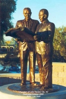
Robert P. McCulloch, Sr, Founder
and
C.V. Wood, Jr., Master Planner
London Bridge was purchased from the city of London on April 18, 1968 for $2,460,000.00. It took three years and another $4,500,000.00 to transport and build the bridge. The . . . — — Map (db m31841) HM
The boundary of the City of London England, established in Roman times, is marked by a heraldic dragon at each entry by freeway. This dragon marks the boundary of London land in Lake Havasu City. — — Map (db m269084) HM
Dedicated to Captain James A. Wheeler, United States Air Force, Tucson, Arizona, and all members of the armed services who have given their lives in the maintenance of freedom. Captain Wheeler was killed in combat April 18, 1965, over South Viet . . . — — Map (db m31839) HM
Opened By
The Right Honorable The Lord Mayor Of London
Alderman Sir Peter Studd G.B.E.M.A.D.Sc.
In The Presence Of
The Honorable Jack Williams
Governor Of Arizona
October 10, 1971
Robert P. McCulloch Sr C.V. Wood Jr. . . . — — Map (db m4328) HM
[Upper Plaque]:
In grateful memory
Robert P. McCulloch, Sr.
Whose purchase of London Bridge
in 1968
saved it for the enjoyment and use
of posterity
[Lower Plaque]:
October 10, 1981
on this 150th Anniversary . . . — — Map (db m6974) HM
Fifteen miles east in the Black Mountains, is the historic Oatman mining district. Many original buildings still exist in the ghost town site. The Tom Reed United Eastern Gold Road and other mines produced more than thirty million dollars of gold . . . — — Map (db m31903) HM
You are standing on the site of what used to be the ARIZONA HOTEL. In 1915, it was one of seven hotels that existed in Oatman during the early years. The hotel had 45 rooms and numerous baths. It had concrete fire walls and two separate water mains . . . — — Map (db m114809) HM
Olive Ann Fairchild, Indian captive and lecturer, daughter of Royse (Royce) and Mary Ann (Sperry) Oatman, was born in Illinois is September 1837 or 1839. In 1850 the family joined a wagon train bound for the part of the Colorado River now in . . . — — Map (db m297410) HM
This turn of the century gold mining camp was on the original road through the Black Mountains and eventually became Route 66. Burrows came with the miners and still roam the streets today.
Get you Kicks on Route 66 in Arizona. — — Map (db m188974) HM
In 1900 Jose Jerez discovered gold here in a
chunk of quartz. It was assayed out 40 ounces to
the ton! The claim was resold for $275,000. By
1907 the mine milled 140,625 ounces of gold
worth $2,250,000. Addwest Minerals acquired
the mine in . . . — — Map (db m50762) HM
Named for a migrating pioneer family attacked and killed by Indians near Gila Bend, Arizona, in 1851.
Some fifty mines operated in the Oatman area. From its beginning in 1904 and through 1931, the Oatman district produced $36,000,000 in ore. . . . — — Map (db m29464) HM
World War I was funded partially by the gold out of these mountains in 1912. Oatman boomed from 1910 to the 1920's. Upwards to 8,000 people lived here. Gold mines were closed about 1942. Mines were needed to mine copper for World War II. Blue Ridge . . . — — Map (db m119942) HM
Oatman was founded around 1906 as part of Arizona's richest gold mining area. Oatman was reborn in the late 1960's and early 1970's as a tourist town. The main attraction was the wild burro herd. The burros roaming the Oatman area are descendants of . . . — — Map (db m78570) HM
This property has
been placed on the
National Registry of
Historic places of the
U.S. Dept. of Interior.
(Formally
Oatman Drug and
Health Club) — — Map (db m29465) HM
Oatman was founded about 1908. By 1931, the area's mines had produced over 1.8 million ounces of gold. By the mid 1930's, the boom was over and in 1942 the last remaining mines were closed as nonessential to the war effort.
Burros first came . . . — — Map (db m18964) HM
Oatman was founded about 1908. By 1931, the area's mines had produced over 1.8 million ounces of gold. By the mid 1930's, the boom was over and in 1942 the last remaining mines were closed as nonessential to the war effort.
Burros first came to . . . — — Map (db m114819) HM
Olive Ann Fairchild, Indian captive and lecturer, daughter of Royse (Royce) and Mary Ann (Sperry) Oatman, was born in Illinois in September 1837 or 1839. In 1850 the family joined a wagon train bound for the part of the Colorado River now in . . . — — Map (db m188959) HM
The Changing Decades
In the decades between the 1930s and 1950s, travellers along Historic Route 66 changed markedly … along with their hopes and dreams, their vehicles and accommodations, and their perspective of the Black Mountains.
. . . — — Map (db m288513) HM
These grounds belong in spirit and enthusiasm to Dallas Quasula Sr., a member of the Hualapai tribe. Dallas, a tribal councilman and elder, was also a highly regarded citizen of the county and graduate of Seligman High School. Dallas served . . . — — Map (db m119933) HM
During the 1930'2 a boater passing through the Canyon discovered a cave which later was found to be rich with "Guano", bat droppings. This material was rich with nitrogen and very useful as fertilizer. The U.S. Guano Corporation had purchased the . . . — — Map (db m99266) HM
This property was listed in the National Register of
Historic Places on March 15, 2012. The John Osterman
Gas Station was one of several privately-owned and
operated businesses in the town of Peach Springs during the 1920's through the 1950's. . . . — — Map (db m58605) HM
This property was listed in the National Register of
Historic Places on November 21, 2003. The Historic
Peach Springs Trading Post, in downtown Peach Springs
circa 1932, was an important commercial enterprise for
Peach Springs citizens and . . . — — Map (db m58607) HM
You are looking into Black Canyon and a narrow,
river-like portion of Lake Mohave. To your left, about 59
miles downstream, is Davis Dam. To your right, 11 miles
upstream, is Hoover Dam. The U.S. Government built
the dams to tame the periodic . . . — — Map (db m111185) HM
First exploration probably by early Spanish explorers, Espejo in 1582 and Farfan in 1589. Explored later by Lt. Amiel W. Whipple in 1854. Important agriculture, mining, milling, and smelting area in our early days. The McCrackin Mine discovered by . . . — — Map (db m68947) HM
With its rugged mountains, deep canyons, stark deserts, and two large blue lakes, America's first national recreation area is a place of great contrasts. Lake Mead National Recreation Area (NRA) was established in 1964, well after the waters of . . . — — Map (db m193366) HM
On the morning of March 23, 1950, an Air Force B-50 Bomber on a routine training mission, exploded and crashed north of the communities of Dateland and Hyder AZ. Two of the 14 crewman on board, Capt. John H. Lee and 1st. Lt. William T. Gentry, . . . — — Map (db m28936) HM
Datelan Army Air Field was established here January 1, 1943. The site was chosen due to the availability of water and the adjacent location of the Yuma Gunnery Range. Construction was completed June 1, 1943. Datelan AAF was a sub-base of Yuma Army . . . — — Map (db m78545) HM
Camps Hyder & Horn were established 10 miles north of Dateland in the fall of 1943. They were 2 of 15 desert camps built to harden and train United States Troops for service in World War II. The Desert Training Center was a simulated theater of . . . — — Map (db m78546) HM
Here trained
For Victory
Under
Desert Skies
The
81st Infantry
Division
The Wildcats
1943
In Memoriam
Privates
Robert J Vilella
Paul M. West
Earl S. Smith
James J. DeCarlo
Lynn Ramsey
Clyde B. Slayton
Arden . . . — — Map (db m28937) HM
In memorium June 28, 1944 a B-17 Training Bomber crashed South of this Point.
Crew Members
2nd. Lt. William A. Richell, 22, Pilot
2nd. Lt. Sheridan B. Marek, 20, Co-Pilot
2nd. Lt. Angus W. MacArthur, 21, Co-Pilot
Sgt. Manteu P. Jones, . . . — — Map (db m248850) HM WM
who carved this farm out of the desert. We, the Wellton-Mohawk Valley Kiwanis Club, dedicate this spot. Here on May 1, 1952 Michael W. Straus, United States Commissioner of Reclamation turned the first water on to lands of the Wellton-Mohawk . . . — — Map (db m28967) HM
Across the Colorado River is "Indian Hill," the site of La Purisima Concepcion mission. Built in 1780 by Spanish explorers, it was destroyed in 1781 when native Quechans revolted, killing all European males. Nothing is left of that structure. . . . — — Map (db m158369) HM
The gray bridge, finished in 1915, is the "Ocean to Ocean" Highway Bridge. This was the final link in a highway stretching from the Atlantic to the Pacific coast. Its presence meant travelers no longer had to wait for the ferry to cross the . . . — — Map (db m158287) HM
In memory of
the inmates, who lost their life
while serving their sentence, at the
Arizona Territorial Prison at Yuma
Aldrete, Simon • Alejandra • Alveres, Thomas • Armbula, Tomas • Arnett, William • Arvizu, Gregorio • Baca, Antonio • . . . — — Map (db m51636) HM
In 1877, the Southern. Pacific Railroad (SPRR) was the first railroad to arrive in the Arizona Territory, crossing the Colorado River from California and arriving in Yuma. Traveling through the scorching desert, the locomotives arrived in Yuma . . . — — Map (db m266543) HM
Recordando a Brian O'Dwyer In 1994 Brian came to Gowan to build a business in Mexico that would provide growth and opportunity for the company and his employees. Walking the fields with farmers, Brian and his Tribe were men with muddy boots. They . . . — — Map (db m191696) HM
Camp Laguna operated from April 1942 to April 1944. It was one of twelve such camps built in the southwestern deserts to train United States troops during World War II.
The Desert Training Center, a simulated theater of operations, included . . . — — Map (db m29061) HM
In 1863 Jacob Snively, founder of Gila City, and right hand to Sam Houston, avenger of the Alamo, following blazes left on the saguaros by Mexican and Conquistador predecessors, came to Castle Dome, and within 15 years, Castle Dome City’s population . . . — — Map (db m48924) HM
In 1859, steamboat entrepreneur George Alonzo Johnson built a riverside home for his bride, Estefana Alvarado. Now known as the Commanding Officer's Quarters, the home is believed to be Arizona's oldest Anglo-built adobe building. In the . . . — — Map (db m28999) HM
Eager to expand it's New World empire, Spain authorized a 1775-1776 expedition to settle the port of San Francisco. The expedition, lead by Juan Bautista de Anza, commander of the Royal Presidio of Tubac, traversed 1000 miles on foot, horseback, . . . — — Map (db m191836) HM
All water for the prison came from the river. Inmates dug a network of tunnels at the base of the hill which would fill with river water. From there water was pumped up into the 85,000 gallon granite-walled tank, also of inmate construction. In . . . — — Map (db m185955) HM
Construction on this adobe home on Madison Avenue began in the 1870's. Pioneer merchant E. F. Sanguinetti purchased the two-room house with its lean-to kitchen in 1890. The building, gardens, and aviaries were developed by Sanguinetti who resided . . . — — Map (db m28971) HM
Early day route from Sonora to California over the path taken by Father Eusebio Kino in 1700 when he sought to discover if California was part of the American mainland. The parched desert along this route has claimed hundreds of lives, particularly . . . — — Map (db m83418) HM
This is the point of discovery for the Flora Temple Mine. In the early 1870’s, a Colorado River steamboat captain named Isaac Polthamus purchased the Flora Temple Mine. This mine was the 2nd patented claim in Arizona (1871). Polthamus and his . . . — — Map (db m91925) HM
Built by John Gandolfo, this brick landmark served as a 635 seat theater and vaudeville house, a WW II USO canteen and was a center of community activity from 1917 to 1950. The third floor ballroom was destroyed by fire in 1925.
Dedicated . . . — — Map (db m28987) HM
John Ghiotto, native of Genoa, came to Yuma in 1890 to work in the Gandolfo store. He went into business for himself and had a chain of four small groceries. His brick home is typical of middle class housing of this period.
Dedicated December . . . — — Map (db m29004) HM
The building is an example of Moderne/Art Deco Style. It served as headquarters for Hollywood stars throughout the 1930 and 40's and was the center of Yuma's social life until 1960.
Dedicated December 1999, by the City of Yuma
for the . . . — — Map (db m29006) HM
In Commemoration
Of the
125th Anniversary of the Founding
of
Immaculate Conception Parish
1866 – 1991
Celebrated on the Feast of the Immaculate Conception
December 8, 1991
Most Rev. Manuel D. Moreno, D.D.
Bishop of the . . . — — Map (db m29024) HM
Senator Giss was born February, 1906, in Minneapolis, Minn. and moved to Arizona in 1937. Being a concerned individual for Arizona's future, Senator Giss entered politics. He served as a member of the Arizona House of Representatives for two years . . . — — Map (db m28986) HM
In 1904 an incorrigible ward, consisting of five steel cages, was constructed on this site. The total budget for the building, including steel cages, corrugated iron roofing and lumber, was five hundred dollars. Approximately 4,000 adobe bricks, . . . — — Map (db m158296) HM
During World War II, the Yuma proving ground of the United States Army Corps of Engineers was known as the Yuma Test Branch, which was used as a floating-bridge test facility. By 1944, more allied troop support was needed to conduct the bridge tests . . . — — Map (db m29059) HM
While the American Revolution brewed on the Atlantic Coast, Spain expanded its New World empire to protect California against the British and Russians. In 1774, Juan Bautista de Anza, commander of the Royal Presidio of Tubac, successfully explored . . . — — Map (db m158299) HM
The main cellblock was built to house up to 204 prisoners, but at times the Superintendent's report stated that up to 240 prisoners were kept here. Each cell was approximately 9 foot X 12 foot and could hold six prisoners. When space became limited, . . . — — Map (db m158292) HM
Designed in the Modernistic/Art Deco style, it retains its original design and use as a lodge. Freemasonry in Yuma began in 1900. Lodge #17 was formed in November, 1901.
Dedicated December 1999, by the City of Yuma for the preservation of . . . — — Map (db m29022) HM
Mormon Battalion Crossing
This monument marks the approximate site of the crossing of the Colorado River by the Mormon Battalion on 10 and 11 January 1847.
The Mormon Battalion consisted of 500 volunteer soldiers from among the . . . — — Map (db m62011) HM
This turn of the century adobe is an example of middle-class housing in Yuma. It is also a fine example of the Anglicized Sonoran style building tradition.
Dedicated December 1999, by the City of Yuma
for the preservation of our heritage. . . . — — Map (db m29003) HM
The "New Yard" was constructed in 1900 to help relieve overcrowding. The entrance to the library was closed and the first four cells were made from the library excavation in the south bank. Eight more cells were dug into the east side of the same . . . — — Map (db m185959) HM
In 1913 after strong campaigning from the citizens of Yuma, Representative Carl Hayden secured funding for this bridge. When completed, it was the only highway bridge across the Colorado River for 1,200 miles. It was partially funded by the Office . . . — — Map (db m46786) HM
This adobe building was constructed in 1872 as an office for the Fort Yuma Quartermaster Depot. It replaced a room in a corner of the depot storehouses where, according to Captain J. G. C. Lee, Quartermaster, ". . .the noise of the arrivals and . . . — — Map (db m29000) HM
Anything a prisoner could not make himself or barter for, he had to do without. As an inmate, forty-eight hours a week were spent working in the fields, quarry, adobe yard, or on assignment in a shop. Whether you needed a tin cup or a new . . . — — Map (db m158293) HM
A steam pump located at the edge of the river propelled muddy Colorado River water through pipes to an elevated holding tank constructed of local rock and mortar with a wood shingle roof to decrease evaporation. Sediment fell to the bottom of the . . . — — Map (db m29001) HM
Boomtown In 1877, the Southern Pacific Railroad brought the first train into Arizona by building a bridge across the Colorado River along Madison Avenue. The bridge design included a section that pivoted open, like a gate, to allow steamboats . . . — — Map (db m266545) HM
On October 25, 1911, pioneer aviator Robert Grant Fowler touched down on this site, becoming the first person to land an airplane in Arizona under its own power. A native Californian, he had departed Los Angles October 19, and completed aviation . . . — — Map (db m29018) HM
The main office and store for E. F. Sanguinetti's extensive business interests. Build of brick, it is the one of the few structures on Main Street to survive the 1916 flood.
Dedicated December 1999, by the City of Yuma
for the . . . — — Map (db m191786) HM
The concrete slabs in front of you were the floors of the shop buildings constructed in 1895. The shops housed the electric generating plant, shoe/ tailor shops and the laundry/bathhouse. The 33 foot x 100 foot adobe building had a corrugated iron . . . — — Map (db m191835) HM
Below the junction of the Gila and the Colorado rivers was the only natural ford on the southern trail to the Pacific. Though often menacing, Indians helped early travelers across on crude rafts. Several ferries operated from 1850 on. Best known . . . — — Map (db m158300) HM
Southern Pacific No. 2521 was built by the Baldwin Locomotive Works in Schenectady, New York, and deliver to the Southern Pacific Railroad in 1907.
In its lifetime, this historic engine logged an estimated 2.5 million miles hauling . . . — — Map (db m266548) HM
The Southern Pacific Hotel was constructed on the immediate east side of the existing 1877 track alignment on the banks of the Colorado River. Construction was started on March 26, 1881.
"The first floor of the hotel is divided into eleven . . . — — Map (db m266546) HM
Wooden coaches were built around 1875 by Southern Pacific Railroad shops in Sacramento, California, and were used for passenger service in the railroad's southern division.
In 1913, this car was converted for railroad maintenance and was then . . . — — Map (db m29002) HM
The best preserved 19th century brick building in Yuma. One of the few structures to survive the flood of 1916. Across the street from the Southern Pacific Roundhouse, it offered groceries, sundries, and a saloon for railroad employees. . . . — — Map (db m29019) HM
During his 1774 exploratory trip, Anza made friends with Chief Olleyquotequiebe (Anza called him “Palma”) of the Quechan Indians, who controlled the river crossing. The Quechans welcomed the 1775 colonizing expedition and supplied beans, . . . — — Map (db m158365) HM
• Cast in 1875
• Stands approximately 3 feet high
• Weighs approximately 800 lbs. with carriage
This bell was cast by W.T. Garratt's Brass and Bell Foundry in San Francisco, California in 1875. A sailing ship brought the bell up the . . . — — Map (db m185957) HM
Between 1846 and 1848, the United States and Mexico went to war. One of the major directives of the United States during this war was to secure its western border and to occupy California and the territory of New Mexico. The government asked for . . . — — Map (db m22686) HM
United States
Post Office
has been placed on the
National Register
of Historic Places
The United States Post Office is a two-story
building of reinforced concrete faced
with native Arizona stone. The design
has strong Beaux-Arts roots, . . . — — Map (db m191672) HM
This early commercial block was built by Jose Maria Venegas as a storehouse/dry goods outlet. The sheltered arcade is typical of southwest design of the period. The family also owned the Yuma Steam laundry in this neighborhood.
Dedicated . . . — — Map (db m29005) HM
Yuma of the 1870's had limited marketplaces. Goods were brought in by steamships or many days' journey through hostile country. Calamities along the journey claimed belongings and supplies more than once. The government compensated by stocking as . . . — — Map (db m158298) HM
In January 1943 the Yuma Test Branch of the Engineer Board of the Corps of Engineers commenced test operations on fixed and floating bridges at Imperial Dam. Tests were conducted in both sluiceways as well as above and below the dam. Transportation . . . — — Map (db m29058) HM
Built in classic Spanish Colonial Revival style on high ground overlooking the Colorado River, it has served as the traditional seat of municipal government.
Dedicated December 1999, by the City of Yuma for the preservation of our heritage. . . . — — Map (db m28985) HM
Dedicated to the memory of the Yuma County, Arizona Veterans who gave their lives for their country in the World War 1917-18 Lt. Col. H. H. Donkersley • Sidney D. Carter • Fermin Coz • Worley Doby • Joaquin Dominguez • Frank Espinoza • Jesse R. . . . — — Map (db m166001) WM
From 1850 to 1877 all travelers crossing the Colorado River used the ferry. Several operated between the mouth of the Gila River and Pilot Knob. Steamboats arrived on the river in 1850 and the first railroad bridge was built in 1877. — — Map (db m29015) HM
Yuma Crossing, used since prehistoric times, played a significant part in the development of the West and continues to influence the affairs of the state and the nation. The Yuma City-County Bicentennial Commission in the spring of 1974 conceived . . . — — Map (db m28984) HM
The Natural Setting The river supported pristine cottonwood / willow gallery forests, mesquite bosques, wetlands, inter-tidal salt flats, and lakes dependent on annual floods for existence. The area yielded a rich harvest of seasonal wild . . . — — Map (db m158377) HM
A Positive Impact Starting in 1905, dams were constructed along the Colorado River that brought positive change to the Southwest. Dams and canals brought a safe and secure source of water and power and enhanced the ability of people to live in . . . — — Map (db m158380) HM
Restoration in Progress The Yuma East Wetlands (YEW) is an innovative restoration project pioneered by the Quechan Indian Tribe and the City of Yuma. The 1,418 acres of the YEW are comprised of native riparian wetland, and aquatic habitats . . . — — Map (db m158390) HM
The concrete slabs before you are all that remain of an early adobe structure. Originally, this building was where prisoners were processed, ate meals, and received medical attention. Later it housed offices, storerooms, barbershop and the two cells . . . — — Map (db m158297) HM
Built in the Spanish Colonial Revival style to complement and capitalize on the Southern Pacific Depot site diagonally across the street. The driving force behind its construction was Yuma Mayor and entrepreneur F.S. Ming.
Dedicated . . . — — Map (db m266560) HM
Pat Tillman died a warrior.
Mike O'Callaghan lost a leg in combat but is better known for the battles he fought in the political arena.
They were good citizens—two of America's finest.
Donal Neil “Mike” O'Callaghan (1929-2004)
Mike . . . — — Map (db m269060) HM
Originally a Native American trail, Bootleg Canyon – also called the Hooch Highway was a well-known backdoor into Boulder City and the Hoover Dam construction site during prohibition. Bootleggers brewed illegal alcohol in stills hidden in . . . — — Map (db m29324) HM
Building the dam required thousands of hands. At least 21,000 workers were required during construction. Approximately six miles from the dam city, Boulder City was constructed to provide accommodations for the workers.
Top
Panorama of . . . — — Map (db m254570) HM
The name of the dam has changed over the years, but the remarkable feat transcends names. The modern name is Hoover after the U.S. president in office during the initial construction. The Hoover Dam, the height of a 60 story building, is the . . . — — Map (db m254579) HM
Hoover Dam has been a magnet for tourists - and their cars -
from the earliest years of its construction.
The Memorial Bridge has reduced the number of vehicles traveling across the dam. This not only improves the visitor experience but also . . . — — Map (db m285147) HM
Best Crossing Site
Seeking the best new bridge site was one of the first major decisions in bypassing the river crossing atop Hoover Dam.
The Project Management Team (PMT) identified 13 alternative routes early in the project. These . . . — — Map (db m285199) HM
One of the finest examples of how civil engineering ingenuity shaped the development of society's quality of life in the 20th century. — — Map (db m31900) HM
From Water to Watts
The nearby switchyards, towers, and high voltage power lines deliver electricity from Hoover Dam generators to Southwestern cities.
The Western Area Power Administration (WAPA) operates and maintains the Hoover - . . . — — Map (db m285167) HM