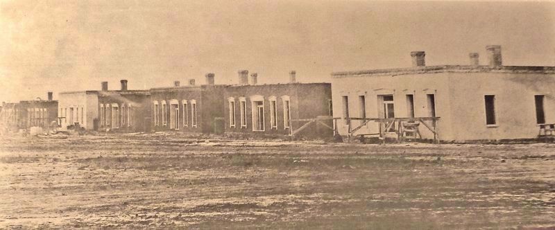
Protective brick coping atop the adobe walls has not yet been added to most of the Officers’ Quarters shown in the top photo, dated 1866. The buildings, pictured ten years later, are complete with porches and fencing. — — Map (db m148999) HM
Throughout the 19th century, military sanitation was far ahead of most civilian practice in the West. The “sinks,” “privies,” “necessaries,” and latrines of the military kept contagious disease at a minimum and even by modern standards were not . . . — — Map (db m149184) HM
Army officers assigned to the garrison here at Fort Union lived with their families in the row of nine houses you see along this side of the parade ground. Each building held two apartments and shared a common kitchen and dining room at the rear. . . . — — Map (db m148998) HM
Soon after a Confederate army from Fort Bliss, Texas invaded southern New Mexico in July 1861, over 200 men found themselves here, working 4-hour shifts, day and night. With picks and shovels they raised a new Fort Union surrounded by earthworks. . . . — — Map (db m148996) HM
Opened by William Becknell in 1821, the Santa Fe Trail became the major trade route to Santa Fe from Missouri River towns. The two main branches, the Cimarron Cutoff and the Mountain Branch, joined at Watrous. Travel over the Trail ceased with the . . . — — Map (db m55199) HM
To us today, Fort Union looks like a single, very large Army base. Soldiers who served here from 1863-1891 saw things in a completely different way. For them, the Post of Fort Union and the Fort Union Quartermaster Depot were like two small towns . . . — — Map (db m149003) HM
Between Fort Riley, Kansas and California you would have found no bigger or better medical facility than the one that once stood here. In 1864 it cost $45,000 to build. This six-ward hospital had from 10 beds to 126 beds over its life. Here a . . . — — Map (db m148976) HM
Think of what you see here as the forerunner of today's busy truck stops on the interstates. Now, freight rides cross-country safe inside boxes of steel and aluminum, rolling on rubber tires. In the mid-1800s, cargo rode under canvas on iron-shod . . . — — Map (db m149006) HM
”More like a village… than a military post” was how one soldier described the First Fort Union — located across the valley where you now see adobe ruins of the later Fort Union Arsenal.
Begun in the summer of 1851, First Fort Union was . . . — — Map (db m148995) HM
If you look straight ahead about a mile, you can see the site of the first Fort Union. There, at the foot of the mesa, soldiers quickly threw up buildings made from logs and uncured, rough-sawn lumber in the summer of 1851. Their mission was to . . . — — Map (db m149182) HM
Today it's tough to look at the low wagon wheel ruts of the Santa Fe Trail — just ahead of you and grasp how many tens of thousands of lives this road turned upside down. Comanche, Kiowa, Jicarilla Apache, Mountain Ute, and other American Indian . . . — — Map (db m149008) HM
The Six Mule Army Wagon contributed to the military's success in the Southwest. With its simple design and iconic red and blue paint scheme, the Six Mule Army Wagon, nicknamed the "Old Army Six Mule", performed the critical role of linking . . . — — Map (db m148980) HM
Unlike its predecessors, the Third Fort Union was carefully planned. Building materials included native stone, adobe bricks — fashioned from soil dug from a field north of the fort site — and bricks manufactured in the nearby town of Las Vegas. . . . — — Map (db m148997) HM
Like surging tides upon the shore, a procession of human cultures has influenced this region. Each new wave of people left unique impressions on the landscape and each other. 1100-1900 Jicarilla Apache, Ute, Comanche, Pueblo, and other . . . — — Map (db m156804) HM
The Santa Fe Trail was a 900-mile overland road that connected Franklin, Missouri, with Santa Fe, New Mexico. Near here, the trail split into the Mountain Route and the Cimarron Route and travelers had to decide which to take to continue east to . . . — — Map (db m156973) HM
Rested and resupplied at Fort Union, traders headed west into the last 130 miles of the long and arduous trip to Santa Fe. They reached the trading post at Watrous first and then the small town of Las Vegas, founded as a trail stop in 1835. One of . . . — — Map (db m156972) HM
Although taken at different times, these two photos show the Transportation Corral (1) and Herders Corral (2). Dozens of wagons and scores of mules were kept here in readiness to transport supplies and troops. Towering haystacks can be seen in the . . . — — Map (db m149186) HM
The Mountain Branch and the Cimarron Cutoff of the Santa Fe Trail meet at Watrous. This important spot on the Trail was first known at La Junta, "junction" in Spanish. In 1879, with the coming of the railroad, it was named for Samuel B. Watrous, a . . . — — Map (db m55198) HM
Watrous - Western Junction of the Santa Fe Trail has been designated a Registered National Historic Landmark Under the provisions of the Historic Sites Act of August 21, 1935 this site possesses exceptional value in commemorating and . . . — — Map (db m148788) HM
Established on the site of an abandoned Indian pueblo, Abiquiú in the mid-18th century became a settlement of Spaniards and genizaros (Hispanicized Indians). In 1776, explorers Fray Francisco Atanacio Dominguez and Fray Silvestre Vélez de Escalante . . . — — Map (db m280183) HM
In 1881 David Baldwin discovered small fossilized bones
on what is now Ghost Ranch. He mailed the bones to
paleontologist Edward Drinker Cope in Philadelphia. Cope had been through the area in the late 1870s and had urged Baldwin to explore and . . . — — Map (db m75212) HM
One of America’s great and most celebrated painters of the twentieth century, Georgia O’Keeffe is known for her unique depictions of natural and architectural forms. She began spending summers painting in Northern New Mexico in 1929 and moved from . . . — — Map (db m280184) HM
The colorful formations exposed here are the slope forming Chinle Shale of Triassic age, deposited in streams, lakes, and floodplains some 250 million years ago and the cliff-forming Entrada Sandstone of Jurassic age deposited as windblown sand some . . . — — Map (db m280185)
Doña Margarita Martín c.1700-1743
Margarita Martín was born in La Soledad sometime around 1700. She married twice, first to Juan Manuel Padilla in 1721 and then
to Bernardo Roybal in 1731. Her will offers
a view of items found in wealthy . . . — — Map (db m308933) HM
Historic Los Luceros includes a Pueblo Indian ruin and an 18th century rancho/hacienda on Sebastián Martin Serrano's 1703 land grant. Evolving out of family inheritance, local artistry and preservation efforts, the complex contains five adobe . . . — — Map (db m308932) HM
Los Luceros was the headquarters of Sebastian
Martin Serrano's 1703 land grant, which ran five
miles along the Rio Grande and 18 miles east to
the peaks of the Sangre de Cristo Mountains. Martin
planted an extensive apple orchard that . . . — — Map (db m308931) HM
1881 Log Bunkhouse • oldest building on railroad 1924 Coal Tipple • 70 ft. high holds 60 ton, fast empty the only wood tipple left 1907 Water Tank • holds 50,000 gal. • unique style with two waterspouts — — Map (db m193153) HM
From a small crossroads town, Chama became an important site on the Denver & Rio Grande Western Railroad after 1880. The Cumbres & Toltec Scenic Railroad is a remnant of the San Juan Extension, a narrow-gauge line which once served the mining . . . — — Map (db m280186) HM
From a small crossroads town, Chama became an important site on the Denver & Rio Grande Western Railroad after 1880. The Cumbres & Toltec Scenic Railroad is a remnant of the San Juan Extension a narrow-gauge line which once served the mining areas . . . — — Map (db m280187) HM
The Survivor 1924 saw the construction of three nearly identical coal tipples along the Denver & Rio Grande rail lines. Only this one survives, due to efforts by the Friends of the Cumbres & Toltec Scenic Railroad to shore up the foundation and . . . — — Map (db m280864) HM
[2012 marker – northwest corner of depot]has been designated a National Historic Landmark This site possesses national significance in illustrating the history of the United States of America 2012 National Park . . . — — Map (db m280909) HM
In 1829-30, Antonio Armijo traveled from Abiquiú to California to trade for mules, thus extending the Old Spanish Trail and opening it to trade between Santa Fe and Los Angeles. His route turned west, near present-day Abiquiú Dam, to Largo Canyon, . . . — — Map (db m280189) HM
Built When Silver Was King This portion of the Denver & Rio Grande narrow gauge railway, known as the San Juan Extension, was built to serve the rich mining areas of western Colorado. In late 1880, the D&RG reached Chama from Denver, CO, . . . — — Map (db m280854) HM
Indians occupied the Chimayo valley centuries before the arrival of the Spaniards. The village of Chimayo, founded in the early 18th century, shortly after the reconquest of New Mexico, has been a center of the Spanish weaving tradition for over 250 . . . — — Map (db m32819) HM
Cordova, originally named Pueblo Quemado after a nearby burned-out Indian Pueblo, was permanently re-settled in 1750 after Indian attacks. It was renamed Cordova in 1900 after a prominent local family. The village chapel, San Antonio de Padua, is an . . . — — Map (db m45675) HM
In 1816, Bernardo Abeyta and the other residents of El Potrero, then a separate community, finished this massive adobe chapel honoring Nuestro Señor de Esquípulas. It is noted for its 6-foot crucifix and its tradition of healing the sick. The . . . — — Map (db m32817) HM
The Jicarilla Apaches, primarily a hunting and gathering group, once occupied vast portions of northeastern New Mexico and southern Colorado. Pressure from Comanche Indians and European settlers eventually pushed them from their homeland. In . . . — — Map (db m280190) HM
During the 19th century, the U nited
States government attempted to establish reservations to separate Indian
tribes from settlers along the frontier.
The Jicarilla Apache initially agreed
to settle on a reservation in 1851, but
unratified . . . — — Map (db m308887) HM
Tewa people lived in this area before the village of El Rito Colorado was settled in the 1830s by residents from the Abiquiú area. The Territorial Legislature of 1909 established the Spanish-American Normal School here to train teachers for northern . . . — — Map (db m280191) HM
This village was settled in the 1830s by residents from the Abiquiú area. The Territorial Legislature of 1909 established the Spanish-American Normal School here to train teachers for northern New Mexico schools. After several changes in name and . . . — — Map (db m280192) HM
This historical church was begun by the first Spanish settlers of the El Rito Valley in 1827 and completed in 1832. Originally flat roofed and with small window openings in the 5 ft. thick walls, it not only served as an imposing temple, but also as . . . — — Map (db m64977) HM
Site of the first United States Geological Survey training center for hydrographers. Those trained here made some of the earliest hydrological studies in the nation, leading to stream-gaging of many streams throughout the country, and thus . . . — — Map (db m148769) HM
On July 29, 1776, two Franciscans, Fray Francisco Atanasio Dominguez and Fray Silvestre Velez de Escalante set out on horseback on an expedition from Santa Fe, New Mexico, to Monterey, California. The purpose of the expedition was two-fold: to open . . . — — Map (db m280193) HM
When it was described by Gaspar Castano de Sosa in 1591, the Española Valley contained about ten Tewa-speaking pueblos, several of which are still occupied today. Juan de Oñate established New Mexico’s first colony here in 1598. Long on the northern . . . — — Map (db m45671) HM
Frank Bond (1863-1945), prominent Española merchant, came from Canada in 1882. In 1887 Bond married May Anna Caffal of Pueblo, Colorado and built the home. The house grew from a two-room adobe to this large structure. Acquired by the city in 1957, . . . — — Map (db m45665) HM
Agueda is the matriarch of Hispanic weaving in New Mexico. From a very young age, she was known for her complex designs and natural dyes. She was the subject of the Academy Award-nominated documentary film, “Agueda Martinez: Our People, Our . . . — — Map (db m280194) HM
Esther Martinez served her community as an educator, linguist and storyteller. Her foremost contributions to our state are documenting and preserving the Tewa language and the art of storytelling. Esther was named a National Heritage Fellow in 2006 . . . — — Map (db m280195) HM
Governor Juan de Oñate set up his headquarters in San Juan Pueblo in 1598, but by 1601 he had moved the Spanish capital across the Rio Grande to Yuque-Yunque Pueblo. Named San Gabriel, it served as the seat of government until 1610, when Oñate's . . . — — Map (db m280196) HM
[ Panel 1: ]
San Juan Parish's Shrine of Our Lady of Lourdes was conceived as place of pilgrimage for those faithful wishing to honor Our Lady and to be given a glimpse
of her place of apparition to St. Bernadette Soubirou in the . . . — — Map (db m32794) HM
The Jicarilla Apaches, a Southern Athabascan
people, migrated to the Southwest from
Northwest Canada. The Jicarilla Apache
preservation homeland extend from Southeastern
Colorado, through northeastern New Mexico, to
the Texas/Oklahoma . . . — — Map (db m308928) HM
Pablita Velarde was an internationally acclaimed artist whose paintings largely depicted Pueblo life. She was commissioned by the WPA art's program to paint murals at Bandelier National Monument. Selected as one of New Mexico's "Living Treasures", . . . — — Map (db m45663) HM
Founded around the fourteenth century, Santa Clara traces its ancestry to Puye, an abandoned site of cave dwellings on the Pajarito Plateau. Increasing tensions with the Spanish led to its participation in the Pueblo Revolt of 1680. The mission . . . — — Map (db m45664) HM
Fort Lowell was established in 1866 to protect the Tierra Amarilla area settlements from the Southern Utes. Originally named Camp Plummer this post was garrisoned by a detachment of New Mexico Volunteers, some of whose descendants live in the area. . . . — — Map (db m280197) HM
In 1832 the Mexican government made a large community land grant to Manuel Martinez and other settlers but settlement was delayed by raids by Utes, Jicarilla Apaches and Navajos. Tierra Amarilla, first called Nutritas, became the Rio Arriba . . . — — Map (db m280198) HM
In 1832 the Mexican government made a large community land grant to Manuel Martinez and other settlers but settlement was delayed by raids by Utes, Jicarilla Apaches and Navajos. Tierra Amarilla, first called Nutritas, became the Rio Arriba . . . — — Map (db m280199) HM
In 1754, Governor Tomás Vélez Cachupín granted land on the Rio Truchas to families from Santa Cruz and Chimayó. Because Nuestra Señora de Rosario de Truchas was on the northern frontier, and subject to attack by Plains Indians, the governor . . . — — Map (db m280200) HM
Ice age glaciers carved these beautiful alpine peaks, among the highest in the New Mexico Rockies, rising to 13,101 feet. Precambrian quartzite, some of the oldest rock in New Mexico, forms the core of the Truchas (“trout”) Peaks, part of the Pecos . . . — — Map (db m280201) HM
Founded in 1875, this small farming community was named La Jolla. It was once famous for finely woven blankets. Here the Camino Real left the Rio Grande and followed a canyon northeast to Embudo Creek where it began a climb over the mountains to . . . — — Map (db m280202) HM
The 30-inch core samples behind you were removed from the concrete foundation of the dam to allow access for future grouting and for a means to measure uplift pressure on the dam.
The sandstone samples on the west end are typical of . . . — — Map (db m177432) HM
George Martinez served the US Army Corps of Engineers from June 1960 through August 1991. He retired as the Maintenance Foreman at Conchas. His strong work ethics helped improve dam operations, maintenance, and the integrity of the facilities and . . . — — Map (db m177431) HM WM
The chance meeting near this spot on Nov. 13, 1821, of Capt. Pedro Gallego's militia with William Becknell's party from Missouri led to the opening of the Santa Fe Trail. — — Map (db m236775) HM
Santa Fe Trail merchants, the Dold brothers built this two-story Territorial style adobe building around the nave of the town’s first church, Nuestra Señora de los Dolores. — — Map (db m148857) HM
Built by M.J. Cavanaugh
for Aniceto Baca.
First housed the O.I. Houghton
Hardware and by 1890 the
Appel Brothers Mercantile.
Saibe Segura's confectionary was
located here following
World War II. — — Map (db m236676) HM
The original Victorian structure here
housed the Furlong Photography Studio
and the Post Office and later the T.J.
Raywood Liquor Company. Rebuilt after
a 1913 fire it became the Bridge Bar.
The original structure was the first
commercial . . . — — Map (db m236662) HM
Frank Chapman maintained a granary
and later a billiard parlor in this oldest
structure on Bridge Street. David
Winternitz later added to the building
for his growing general
hardware business. — — Map (db m236696) HM
John Hill was the "supervising architect" using a Kirchner & Kirchner design. Built during a surge of civic improvements in New Town which included sidewalks, parks, and schools. Said to be the first municipal building in New Mexico. The structure . . . — — Map (db m45890) HM
Built for Andres Dold
Designed by Charles Wheelock
Site of Brownlee, Winters & Co.,
druggists, before being sold to
attorney John De Witt Veeder.
The Dold brothers, Andres & John,
were listed among the top five wealth
holders in New Mexico . . . — — Map (db m236738) HM
Dr. Meta L. Christy. Meta L. Christy, DO, is recognized by the American Osteopathic Association as the first black osteopath. Dr. Christy graduated in 1921 from the Philadelphia College of Osteopathic Medicine as its first black . . . — — Map (db m45889) HM
Design by E.W. Hart • Built by M. M. Sundt
Named for Las Vegas’s first mayor, merchant, and benefactor, Don Eugenio Romero. The Fire Company was formed in 1882 and continued in service as a volunteer organization until 2003. Throughout that . . . — — Map (db m64894) HM
The Engine was built for the Santa Fe Railroad Co. by the Baldwin Locomotive Works, in 1902 & used in regular service on various divisions of the Santa Fe Railroad in New Mexico, for 51 years. It's last trip in railroad service ended in Belen, . . . — — Map (db m45888) HM
Fabiola Cabeza de Baca Gilbert Raised on a ranch at La Liendre, Fabiola received a degree from New Mexico Normal School. She worked as a rural teacher and an agricultural Home Extension agent. In the 1930s, she became a charter member of La . . . — — Map (db m280213) HM
Contractor: Charles Stebbins &
Frank Martsoff
Founded by pioneer bankers, the
Raynolds brothers, the First National
Bank expanded to Albuquerque and
El Paso. — — Map (db m236702) HM
Once the largest post in the Southwest, Fort Union was established to control the Jicarilla Apaches and Utes, to protect the Santa Fe Trail, and to serve as a supply depot for other New Mexico forts. The arrival of the railroad and the . . . — — Map (db m55197) HM
Interstate 25 cuts through dipping strata that form hogback ridges between the Great Plains and the south end of the Rocky Mountains. The Santa Fe Trail from here to Santa Fe, followed a natural valley eroded in less resistant strata between the . . . — — Map (db m55196) HM
“Don Luis” Stern’s trademark slogan was “La Tienda Barata”—or the inexpensive shop. Later the site of the West Las Vegas Town Hall and jail. The cells still exist in the rear of the building. — — Map (db m64897) HM
The Mexican-American War had just begun in 1846, when Brigadier General Stephen Watts Kearny brought a regiment of U.S. soldiers and volunteers from the Missouri River into Las Vegas. From a rooftop overlooking the Las Vegas plaza he proclaimed . . . — — Map (db m236778) HM
Old Town Las Vegas property owners and over 60 private investors created an innovative partnership to rehabilitate 15 buildings in the Plaza, Bridge Street and Distrito de las Escuelas National Historic Districts. La Plaza Vieja Partnership was a . . . — — Map (db m236688) HM
Las Vegas served as an important stop on the Santa Fe Trail and later as a major railroad center. Here General Kearny announced the annexation of New Mexico by the U.S. in 1846. In 1862, during the Confederate occupation of Santa Fe, Las Vegas . . . — — Map (db m45887) HM
Louis Ilfeld was the attorney for
the Charles Ilfeld Company. The building
later housed the popular
La Galleria de los Artesanos. — — Map (db m236732) HM
Originally a two-story Victorian
hardware store for Marwede, Brumley &
Co., then restructured by Ludwig Ilfeld
after a 1913 fire, this building later
housed the N.T. and
Fair Department Stores. — — Map (db m236665) HM
One of the oldest buildings in Las Vegas.
Home of Alcalde Juan de Dios Maese.
Site of General Stephen Watts Kearny's
proclamation claiming Nuevo Mexico
for the United States, August 15, 1846. — — Map (db m236726) HM
Built by the Maloof family on the
site of the W. H. Shupp Carriage
Manufactory, called the “best carriage
works in the Territory,” which
supplied rolling stock throughout
New Mexico and Arizona. The El Rialto
Restaurant was established . . . — — Map (db m236693) HM
Built by Charles Blanchard. Site of Paul Marcellino's Music Hall. Boffo and Perez Marcellino were also fruit dealers on the Plaza. Korte's Furniture has been located here since 1957 — — Map (db m236690) HM
Architect: Charles Wheelock • Contractor: John Bennett Wooten Built by a consortium led by Benigno Romero and Jean Pendaries to replace the two-story Territorial Style adobe Las Vegas Hotel. — — Map (db m64925) HM
Mr. Acalde, and people of New Mexico: I have come amongst you by the orders of my government, to take possession of your country, and extend over it the law of the United States, we consider it, and have done so for some time, a part of the . . . — — Map (db m148846) HM
Near this spot on November 13, 1821, a band of six Missouri traders led by William Becknell, encountered a force of more than 400 Mexican soldiers, militia, and Pueblo Indians under the command of Caption Pedro Ignacio Gallego. This . . . — — Map (db m280214) HM
Architects: Issac H. & William M. Rapp
Built by Secundino and Cleofes Romero.
One of the last California Mission
Revival Style buildings built in
Las Vegas. Drug stores have occupied
this corner of the Plaza since the
arrival of the railroad . . . — — Map (db m236700) HM
Home of Las Vegas's founder Miguel
Romero y Baca, and family, this
structure was rebuilt by District Court
stenographer William E. Gortner. — — Map (db m236724) HM
The Veeder Brothers were attorneys
and community leaders. They
resided on the second floor while
Hofmeister's Grocery occupied
the first floor. This is the only
Panel Brick Style building on the Plaza. — — Map (db m236750) HM
James Gang members Dick Liddell and
Robert Ford, who was convicted and
pardoned for shooting Jesse James in
the back, opened the Bank Saloon here. — — Map (db m236669) HM
At age nineteen, David Chevalier
Winters ran the Trinidad Enterprise
newspaper before coming to Las Vegas
in 1880 as a druggist. The building was
later a saloon and billiard parlor. — — Map (db m236685) HM
Built by M.M. Sundt
Architects: Issac H. & William M. Rapp
The YMCA was organized in Las Vegas in 1900 with Attorney A.T. Rogers as president. The "Y" flourished for two decades before closing in 1924. The building then served as the Las Vegas . . . — — Map (db m45891) HM
453 entries matched your criteria. Entries 101 through 200 are listed above. ⊲ Previous 100 — Next 100 ⊳