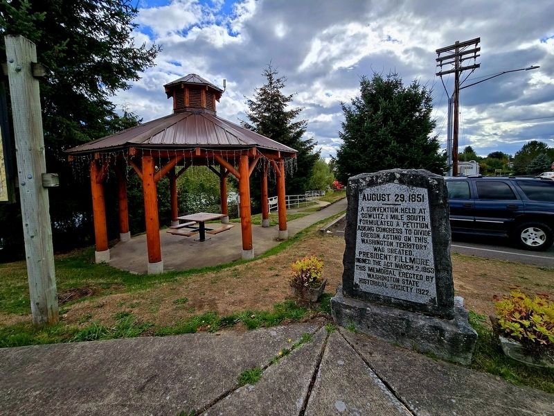
On Cowlitz Street (State Road 505) at Front Street, on the left when traveling east on Cowlitz Street.
A convention, held at
Cowlitz 1 mile south
formulated a petition
asking Congress to divide
Oregon. Acting on this,
Washington Territory
was created.
President Fillmore
signed the act March 2, 1853. — — Map (db m291864) HM
Near Chinook Park Road near Coast Guard Road (U.S. 101).
"nine feet from the points of the wings"
On November 18, 1805, William Clark led a party of eleven men on an excursion to Cape Disappointment and the Pacific Ocean. As they started out that morning, the explorers followed a route . . . — — Map (db m308815) HM
Near U.S. 101 1.7 miles west of State Highway 401, on the right when traveling west.
A Collision of Cultures
First they came by sea and then by land - the Euro-American presence swelled through the region. The newcomers brought strange illnesses, like smallpox and malaria, and unwittingly spread plagues of death to the . . . — — Map (db m177402) HM
On U.S. 101 0.6 miles State Highway 401, on the left when traveling west. Reported missing.
Here the Columbia River, the mightiest river flowing into the Pacific Ocean from the American continents, ends its journey. Native people have lived along the banks of this river and fished its waters for thousands of years.
Euro-American . . . — — Map (db m177312) HM
On U.S. 101 at Columbia Lane, on the right when traveling south on U.S. 101.
Here was the home of the Chinook Indians and their great chief, Comcomly.
Capt. Robert Gray dropped anchor near here after his discovery of the Columbia River in 1792.
In the days of the fur trade this area was witness to many stirring . . . — — Map (db m125769) HM
Near U.S. 101 1.7 miles west of State Route 401, on the right when traveling west.
The Chinook people remember the significance of Qiqayaqilxam and have handed this knowledge down through the generations. They continue to live along the lower Columbia River and cherish this place. Their old ways — from art and language to fishing . . . — — Map (db m177356) HM
Near U.S. 101 1.7 miles State Route 401, on the right when traveling west.
After the U.S. government's failure to ratify the Tansy Point treaties signed by chiefs of five Chinookan tribes, the Chinook continued to hold tightly to their identity as a tribe and to their homeland. In 1855 on the Chehalis River, Washington . . . — — Map (db m177353) HM
Near U.S. 101 1.7 miles west of State Route 401, on the right when traveling west.
In 1904, P.J. McGowan donated the land and paid for the construction of a Catholic church. Built of Port Orford cedar, the church sat 150 worshippers. In the town's heyday, many families lived and worked here. After the cannery moved and fish traps . . . — — Map (db m177352) HM
Near U.S. 101 1.7 miles west of State Route 401, on the right when traveling west.
The Chinook commanded the mouth of the Columbia and lands up the coast to Willapa Bay in the north and down the coast to Tillamook head in the south going back centuries. They lived at the heart of a vast trade network, and served as middlemen, who . . . — — Map (db m177358) HM
Near U.S. 101 1.7 miles west of State Highway 401, on the right when traveling west.
The Search for the Northwest Passage
How did Euro-Americans lay claim to this place? For centuries, explorers sent by European nations with imperial ambitions sought the Northwest Passage — a navigable sea route connecting the Atlantic and . . . — — Map (db m177405) HM
On U.S. 101 1.7 miles west of State Route 401, on the right when traveling west.
This place — where river meets ocean – is one of many stories. The Chinook people lived here at Qiqayaqilxam, or Middle Village, for countless generations. Qiqayaqilxam is one of several villages that stretched from Cape Disappointment to Pillar . . . — — Map (db m177411) HM
Near U.S. 101 1.8 miles west of State Route 401, on the right when traveling west.
The Chinook people have lived along the Pacific Coast for countless generations — in fact, the Chinook say their ancestors were here at the end of the last ice age, when the waters and forests were very different. The people of this place would have . . . — — Map (db m177409) HM
At Cape Disappointment the West Coast's largest river meets the world's largest ocean. From the vantage of this rocky headland, you can see the confluence of these two massive water systems.
This is a place where life flourishes. The mixing of . . . — — Map (db m308825) HM
On North Head Road 1.6 miles north of Robert Gray Drive (Washington Route 100), on the left when traveling north.
Sailing a ship into the narrow channel at the mouth of the Columbia River was always dangerous and often deadly. Sailing ships would frequently be forced to wait for days and sometimes weeks for the weather to be right to "cross the bar."
Even . . . — — Map (db m116577) HM
On North Head Road 1.6 miles north of Robert Gray Drive (Washington Route 100), on the left when traveling north.
In the past two centuries there have been many changes at Beard's Hollow. Historically, the Chinook Indians visited the tide pools near the water's edge to collect sea life for food and shells to use as tools and decorations.
When the Lewis and . . . — — Map (db m116578) HM
Near Cape Disappointment Road 0.4 miles south of Coast Guard Road when traveling south.
The lighthouse has watched over the entrance of the Columbia River since was first lit on October 15, 1856. It stands fifty-three feet tall, has a focal plane of 220 feet above the sea, and tapers from a diameter of fourteen feet four inches at . . . — — Map (db m116607) HM
On Lake Street east of 1st Avenue South, on the right when traveling east.
"It is estimated that with two canneries, the lumbering, cranberry and railroad interests centering at Ilwaco annually put into circulation at this town about $600,000. This is a solid town and is entitled to the attention of all visitors to . . . — — Map (db m116580) HM
Near Cape Disappointment Road 0.4 miles south of Coast Guard Road when traveling south.
The U.S. Army constructed Fort Canby, along with Fort Columbia and Fort Stevens, to defend the entrance to the Columbia River from enemy warships. U.S. Army troops manned the forts from the mid-19th century until the end of World War II.
The . . . — — Map (db m116597) HM
On Ortelius Drive at Capt Robert Gray Dr on Ortelius Drive.
John Edmund Pickernell
New Hampshire 1818
Washington Terr 1877
Wife Tonwah
Settled this site 1842
Signatory Champoeg Convention 1843 — — Map (db m288784) HM
Near Cape Disappointment Road 0.4 miles south of Coast Guard Road when traveling south.
The fort had barracks for the men, cottages for officers and their families, and a large residence for the commanding officer. Other buildings included the post exchange, which was much like a general store, and the guardhouse, which served as . . . — — Map (db m116595) HM
November 18, Monday 1805
William Clark recorded in his
journal that on this date:
"I set out with 10 men and my man York to the ocian by land.... (later in the day) … I found Capt. Lewis name on a tree. I also engraved my name.... I . . . — — Map (db m120771) HM
Near North Head Lighthouse Road 0.8 miles west of North Head Road, on the left when traveling west.
Working and Living on North Head
Lighthouse keepers maintained the North Head Lighthouse from 1898 until its automation in 1961. Keeping the light burning 365 days a year was arduous, repetitive work.
Keepers carried gallons of oil up . . . — — Map (db m116574) HM
On Bolstad West near Ocean Beach Boulevard, on the left when traveling west.
{This trapezoidal marker has plaques on three sides and three-dimensional bronze model of local volcanos on the table]
Mt. Jefferson
Named for President Jefferson
By Lewis and Clark
Elevation: 10,493 feet
Age: 300,000 years . . . — — Map (db m308885) HM
[Two markers are in the kiosk.]
"his Hat...made with a double Cone"
Chief Sakamokawa, for whom this town was named, lived in a village of the Wahkiakum people near here. Lewis and Clark met the chief while wintering at Fort Clatsop on . . . — — Map (db m308891) HM
On Lewis and Clark Trail Highway (State Highway 401) near Hungry Harbor Lane, on the right when traveling east.
"Certain it is they are the best canoe navigators I ever saw." William Clark, November 11, 1805
For centuries, crossing the Columbia River was a major challenge. At the time of the Lewis and Clark Expedition, the Corps watched in . . . — — Map (db m308834) HM
On Lewis and Clark Trail Highway (Washington Route 401) near Hungry Harbor Lane, on the right when traveling east.
Imagine being stuck outside in a driving rain for six days and nights. Corps of Discovery members spent six miserable days beached by a storm in this "dismal nitch" along the Columbia River. Wet, cold, and hungry, they were astonished when five . . . — — Map (db m308833) HM
Near Lewis and Clark Trail Highway (State Highway 401), on the right when traveling east.
Journal of William Clark
About 3 o’clock the Wind luled and the river became calm. I had the canoes loaded in great haste and set out from this dismal nitch. There We have been confined for 6 days past.
Three days earlier . . . — — Map (db m308888) HM
On Lewis and Clark Trail Highway (State Highway 401) near Hungry Harbor Lane, on the right when traveling east.
Millions of salmon once swam up the Columbia River to spawn every year. Salmon were the staple for the many tribes that lived along its banks. Traders carried fish up and down the river to trade for other goods. Later white settlers joined the . . . — — Map (db m308836) HM
On State Highway 6 at Camp 1 Road, on the left when traveling west on State Highway 6.
On the hill behind is the grave of Willie Keil, nineteen year old son of Dr. William Keil, leader of the Bethel Colony that came west to settle here in November, 1855.
Willie was to have driven the leading team in the wagon train which was to . . . — — Map (db m129100) HM
On School Road west of Territory Road, on the left when traveling west.
Pacific County was the third county in Washington Territory, and Oysterville served as county seat from 1855 to 1893. In 1875, taxpayers built a courthouse and jail at this location and it served for all county business until "South Bend Raiders" . . . — — Map (db m302237) HM
On School Road west of Territory Road, on the right when traveling west.
Schools & Education in Oysterville
The Oysterville Schoolhouse was built in 1907 and was used by School
District No. 1 of Pacific County for fifty years until consolidation in 1957.
Since then, though owned by the Ocean Beach School . . . — — Map (db m302236) HM
On Duryea Street at 5th Street, on the right when traveling west on Duryea Street.
Registered National
Historic Place
Washington State Advisory Council
on Historic Preservation
Raymond Public Library
Under the provisions of the
National Historic Preservation
Act of 1966, this property possesses
exceptional . . . — — Map (db m197148) HM
On U.S. 101 at milepost 46, 2.3 miles south of Bruceport County Park Road, on the right when traveling south. Reported missing.
The deserted site of a famous pioneer village, once a county seat, is one mile northward on Willapa Bay, formerly called Shoalwater Bay. The crew of the oyster schooner "Robert Bruce" settled here in December 1851 after that craft had burned. . . . — — Map (db m305061) HM
On Memorial Drive south of West Cowlitz Street, on the right when traveling south.
Registered National Historic Place Washington State Advisory Council on Historic Preservation
Pacific County Courthouse
Under the provisions of the National Historic Preservation Act of 1966, this property possesses . . . — — Map (db m129143) HM
Near Forest Road NF-99 15 miles Forest Road NF-25.
Mount Adams. Mount Hood. Mount St. Helens. These serene, snow-covered mountains beckon one to come closer. But beware. These mountains were born by repeated, often violent eruptions of ash, lava, and pumice. Their eruptions and landslides created . . . — — Map (db m158995) HM
On Forest Road NF-99 4.7 miles west of Forest Road NF-25.
Gary Rosenquist wanted eruption pictures. On May 17, 1980, he and friends Joel and Linda Harvey, their 10-year-old son Jo-Jo, and William Dilley drove down from Tacoma. They camped here, at Bear Meadow, 11 miles northeast of Mount St. Helens.
. . . — — Map (db m84463) HM
Near Forest Road NF-99 15 miles Forest Road NF-25.
Native people knew her. Their names for the mountain translated to "Fire Mountain" or "Smoker." They watched her erupt repeatedly, building most of the visible mountain over the last 2,800 years. Eruptions and heavy ash fall caused them to abandon . . . — — Map (db m158994) HM
On Forest Road NF-99 2.8 miles west of Forest Road NF-380.
The 1980 lateral blast shot hot rock, ash and debris northward at hundreds of miles per hour. For three minutes, the blast pummeled slopes facing the volcano, like those on your right, leaving few survivors. Slopes closest to the volcano were . . . — — Map (db m190631) HM
This landscape is a monument to the Earth’s power.
The incredible story began on March 20, 1980, when magma began rising into Mount St. Helens. The volcano’s summit diverted the magma sideways, shoving the northern slope outward at a rate of . . . — — Map (db m84949) HM
You are looking at a past and future old-growth forest. On May 18, 1980, the lush ecosystem flanking the north side of Mount St. Helens was buried beneath a massive landslide, and covered repeatedly with searing avalanches of hot gases and . . . — — Map (db m158992) HM
On Forest Road NF-99 6.6 miles Forest Road NF-25, on the left.
On May 18, 1980, the eastern edge of the searing lateral blast
rolled up and over ridges to your right. It tore through the Clearwater Valley, lifting just behind where you stand. The blast left a gray patchwork of fallen and standing dead . . . — — Map (db m84911) HM
On Home Vally Park Road near Evergreen Highway ( Highway 14), on the right when traveling south.
"a remarkable circumstance"
The Lewis and Clark Expedition encountered a mysterious underwater forest at several places along the Columbia River; from west of Stevenson to the Kackitat River including the area in front of you. . . . — — Map (db m310009) HM
On Evergreen Highway (Washington Route 14) near Kueffler Road, on the right when traveling east.
"remarkable high detached rock"
While scouting a passage through the "Great Shoote," treacherous rapids that once existed a few miles upstream from here, William Clark and Joseph Field of the Lewis and Clark Expedition . . . — — Map (db m309878) HM
Near Doetsch Ranch Road near Evergreen Highway (U.S. 14), on the right when traveling east.
Beacon for Travelers
For thousands of years, travelers on the Columbia River marked their progress by Beacon Rock. For downriver travelers, the rock signified the end of the rapids and the beginning of the tidal influences of the Pacific . . . — — Map (db m309795) HM
"a great orniment...highly prised by them"
On April 10, 1806, the explorers of the Lewis and Clark Expedition stopped for breakfast at the "Clah-dah lab" village located along the Columbia River downstream from here. When the . . . — — Map (db m309881) HM
On Evergreen Highway (Washington Route 14) near Kueffler Road, on the right when traveling east.
Beacon Rock is a remnant of a young volcano that erupted just 57,000 years ago. What you see today is its tough inner core of cooled, hardened lava. This lava plug was exposed when powerful Ice Age floods swept around it again and again.
Climb . . . — — Map (db m309877) HM
On Evergreen Highway (Route 14 at milepost 40.8) at Wauna Lake Road, on the right when traveling east on Evergreen Highway.
For centuries, the Columbia's whitewater rapids forced river travelers to beach their boats and portage belongings along the shore. Local Indians held dominion over this key trade route that linked the coast to the inland plateau.
In the . . . — — Map (db m309945) HM
Near Doetsch Ranch Road near Evergreen Highway (State Highway 14), on the right when traveling east.
Welcome ...
to the homelands of the American Indian tribes of the Columbia River. Lewis and Clark encountered native people every day while traveling through this region. As you travel the Lewis and Clark Trail and across tidal homelands, . . . — — Map (db m309815) HM
Near Doetsch Ranch Road (State Road 14) near Evergreen Highway (State Highway 14), on the right when traveling east.
William Clark / Meriwether Lewis
" my friend ... If therefore there is anything...in this enterprise which would induce you to participate with me in it's fatigues, it's dangers and it's honors, believe me there is no man on earth . . . — — Map (db m309794) HM
Near Doetsch Ranch Road near Evergreen Highway (State Highway 14), on the right when traveling east.
The Grandeur and History of the Columbia River Gorge
Welcome to Beacon Rock State Park! As you explore the Che-che-op-tin Trail, you will learn about the layers of history that have shaped this landscape.
You will marvel at the . . . — — Map (db m309813) HM
On Evergreen Highway (at milepost 40.8) at Lake Wauna Road, on the right when traveling east on Evergreen Highway.
The far off whistle of an approaching train held promise for residents of isolated settlements hugging the north Columbia River shore. Trains linked friends and family, carried crops to Portland's shipping centers, and introduced manufactured goods . . . — — Map (db m309946) HM
Near Evergreen Highway (Washington Route 14 at milepost 36), on the right when traveling east.
Beacon Rock was first described and named by Captains Lewis and Clark October 31, 1805, enroute to the Pacific Ocean.
Henry J. Biddle purchased Beacon Rock in 1915 to preserve it for posterity and completed the trail in 1918. His son Spencer . . . — — Map (db m58810) HM
On 2nd Street, aka Lewis and Clark Highway (Washington Route 14) near Russell Avenue, on the right when traveling east.
The February, 1903, edition of the Skamania County Pioneer heralded the arrival of Dr. Thomas Carr Avary from Atlanta, Georgia who "proposed to practice the profession of medicine and to become permanently identified with Stevenson and . . . — — Map (db m158178) HM
Near Russell Avenue near Southwest Cascade Avenue.
"these rapids...extreemly difficult"
On their homeward journey in April 1806, the Lewis and Clark Expedition reached the intimidating stretch of rapids William Clark named the "Great Shoote," Unable to paddle through the . . . — — Map (db m158231) HM
On 2nd Street, aka Lewis and Clark Highway, on the left when traveling east.
The first trains and automobiles chugged through Stevenson in 1908, a few years after Lewis and Christian Aalvik has built these two boilings that share a common roof.
Lewis Aalvik rented the east building to a hardware store in 1912. . . . — — Map (db m158176) HM
Near Southwest Cascade Avenue near Leavens Street, on the right when traveling west.
Poets, painters, and travelers have been inspired by the rugged beauty of the Columbia River Gorge - beauty that was shaped in large part by a single series of cataclysmic events that ended just 12,000 years ago.
As the massive Cordilleran Ice . . . — — Map (db m158233) HM
On Southwest Rock Creek Drive near Foster Creek Road.
(two markers are mounted on this kiosk)
Master Traders
The Lewis and Clark Expedition first met Chinookan tribes as they traveled through the Columbia River Gorge in autumn 1805. At the time, Chinookan society . . . — — Map (db m158244) HM
On Southwest Russell Avenue at 1st Street, on the right on Southwest Russell Avenue.
Bank Open
Stevenson's first bank opened for business in 1907 with William P. Christensen as the first cashier. George F. Christensen, Sr. joined the bank in 1912 and was elected president in 1920.
Great Depression Threatens Bank . . . — — Map (db m158180) HM
October 30, 1805
William Clark recorded in his journal that on this date, “A wet disagreeable evening, the only wood we could get to burn on this “little island” on which we have encamped is the newly discovered ash which makes a tolerable . . . — — Map (db m263959) HM
The shriek of steam through a brass whistle, ringing across the Columbia's waters and echoing off the Gorge cliffs. signaled the approach of a steamboat. In early-day Stevenson, a sternwheeler arrival was a high point of a pioneer's day, often . . . — — Map (db m158230) HM
On 2nd Street, aka Lewis and Clark Highway (Washington Route 14) near Leavens Street, on the left when traveling west.
George Stevenson stood on the north bank of the Columbia River, listening to it roar through this narrow Gorge, and envisioned a community strategically located for commerce. Every person traveling this liquid highway stopped here above the Cascades . . . — — Map (db m158175) HM
On Evergreen Highway (Washington Route 14) north of Bridge of the Gods Road, on the right when traveling north.
The rocks project into the river in many places and have the appearance of having fallen from the high hills…
This part of the river resembles a pond partly drained leaving many stumps bare both in & out of the water…
We can plainly hear the . . . — — Map (db m112268) HM
On Southwest Cascade Avenue near Leavens Street, on the right when traveling west.
If you are admiring the view upriver to Wind Mountain, you're in good company. Travelers throughout history have been awed by the grandeur of the steep cliffs and unique mountain formations of the Columbia River Gorge. Early journal entries from . . . — — Map (db m158238) HM
On Lewis and Clark Highway (Washington Route 14) near Cook-Underwood Road, on the right when traveling east.
In the early 1900s, lush evergreen forests covered the rugged mountains on either side of the Columbia River, providing a wealths of fuel and building material. In this steep, wet country, water was a perfect conveyance.
Sawmills were located in . . . — — Map (db m158172) HM
On Main Street (Washington Route 409) south of Butler Street, on the right when traveling south.
This site, long the home and hunting ground of the Indian, was first sighted by white man in 1792 when Lt. Broughton was sent by Capt. Vancouver to verify the Gray’s reported discovery of the Columbia, and visited by Lewis and Clark in 1805 on . . . — — Map (db m116586) HM
On Ocean Beach Highway (Route 4 at milepost 45), on the right when traveling east.
"Camped on a Bed of Stones"
On November 6, 1805, the Lewis and Clark Expedition paddled down this section of the Columbia River in search of a suitable location to make the evening camp. The rocky shore, dense forests, and . . . — — Map (db m309054) HM
On Covered Bridge Road 0.1 miles south of Loop Road, on the right when traveling south.
Owned and operated by the Wahkiakum Community Foundation, the five-acre Ahlberg Park was purchased in 2007 with funding from private donors and the taxpayers of Washington State with the support of late County Commissioner Mark Linguist, State . . . — — Map (db m116591) HM
On Covered Bridge Road 0.1 miles south of Loop Road, on the right when traveling south.
Under the provisions of the National
Historic Preservation Act of
October 15, 1966, this property
possesses exceptional value in
commemorating, or illustrating
American history
Placed on the National Register on
Nov. 23, 1971 . . . — — Map (db m116590) HM
On State Road 400 at West Sunny Side Road, on the left when traveling west on State Road 400.
"we offered to purchase some of their fish"
The Lewis and Clark Expedition stopped at a Cathlamet camp located on a large island (now Puget Island) on March 25, 1806. Here the explorers met some native people fishing for sturgeon. They . . . — — Map (db m309042) HM
171 entries matched your criteria. Entries 101 through 171 are listed above. ⊲ Previous 100