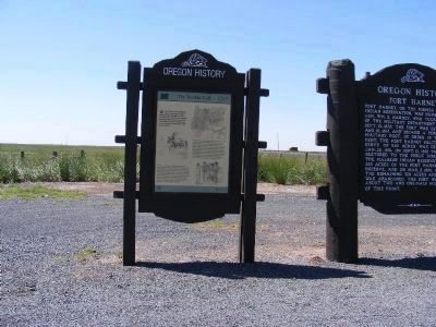
Fort Harney, on the former Malheur Indian Reservation, was named for Gen. Wm. S. Harney, who took command of the Military Department of Oregon, Sept. 13, 1858. The fort was established Aug. 10, 1867, and became a permanent Military Post. By order of . . . — — Map (db m63026) HM
Pioneer Cattleman and Artisan in Wrought Iron
Designer of Harney County's Early Cattle Brands
Organized Two Pioneer Cooperatives
Sponsored Lumber Milling as Our Second Industry
Harney County's First Water Master
Resident 1883 – . . . — — Map (db m305058) HM
Weary Oregon Trail emigrants, eager to ease travel or gain mileage, often attempted cutoffs and shortcuts. While many of these alternate routes proved successful, others did not--they became roads to ruin for some and the end of the trail for . . . — — Map (db m63032) HM
On February 9, 1945 at approximately 10 PM this aircraft, a Consolidated B-24D, serial number 42-40427,
crashed at this location in the Pueblo Mountains. The plane was on a "round robin" navigation training
mission from Gowen Field near Boise, . . . — — Map (db m275414) HM
In memory of:
Elsie Mitchell Age 26
Dick Patzke Age 14
Jay Gifford Age 13
Edward Engen Age 13
Joan Patzke Age 13
Sherman Shoemaker Age 11
Who died here May 5, 1945 by Japanese bomb explosion.
Only place on the American . . . — — Map (db m112534) HM WM
When a Japanese balloon bomb exploded at
this site, Elsie Mitchell and her Sunday school
class of five children, out on an early spring
fishing outing, were killed. They were the only
World War II casualties to occur on the North
American . . . — — Map (db m112595) HM
The history of the west is linked with the idea of finding a new home in a challenging land. We call it homesteading.
During the Pleistocene epoch, homesteaders in the Fort Rock Basin were mammoths, camels, horses, flamingos, and . . . — — Map (db m113604) HM
The Homestead Act of 1862 inspired thousands to seek land in the West. The law allowed heads of households, widows, and all single people over 21 years old to purchase 160 acres at $1.25 per acre, or by paying a $15 filing fee after 5 years of . . . — — Map (db m113592) HM
“Reuben Long, has lived on the desert all his life, taking the cold, the wind, and the pitiless summer sun, and giving back gentleness and understanding.
He is known to thousands as a desert philosopher, with wit and wisdom far beyond . . . — — Map (db m113572) HM
Fort Rock, towering above you to the north and west, is one of Oregon's most interesting geologic features.
Geologists believe it was formed near the end of the Ice Age some 10,000 to 12,000 years ago during a period of frequent volcanic . . . — — Map (db m113575) HM
Fort Rock is the remnant of a maar volcano or tuff ring, formed when rising basaltic magma encountered water and exploded violently. The exploded debris – called tuff – fell back to earth around the volcanic vent to form this . . . — — Map (db m113585) HM
The Fort Rock Grange was organized in 1930 during the great
depression, a time of hardship, drought, and struggle for those living
in the Fort Rock Valley. There were 17 charter members, whose
names hang on the north wall of the main hall. . . . — — Map (db m189155) HM
Ten thousand years ago, Fort Rock was prime real estate for cave-dwelling families. Food was plentiful and there was a great lake where you stand. Walk the trail of this giant "tuff ring" and you'll discover dynamic strands of nature woven . . . — — Map (db m113569) HM
The 1909 Enlarged Homestead Act fueled a landrush that began with the Homestead Act of 1862.
The Act allowed qualified individuals to claim 320 acres by building a residence and cultivating 40 acres.
Motivated by dreams of a "Garden of . . . — — Map (db m113590) HM
Reub Long was a lifelong cowboy of the Oregon desert.
When Reub was two years old, his family moved from Lakeview to Christmas Lake (about 30 miles S.E. of Fort Rock).
By the time he was twelve, he and his horse "...were out doing a man's . . . — — Map (db m113573) HM
They say it happened more than 100,000 years ago.
Molten rock, squeezing its way toward the surface, ran into groundwater. The result?
Great explosions of steam, lake-bed mud, and billions of glass shards.
Wave after wave of this boiling . . . — — Map (db m113570) HM
Near the end of the last Ice Age, America's first people migrated into this lake-filled basin, finding a climate cooler than today's.
A warming trend increased evaporation and the lake shrank. Soon these people discovered caves carved by waves . . . — — Map (db m113571) HM
Behind you to the east is a steep cliff called Abert Rim, made of many layers of hardened lava flows. This 30-mile-long, 2,500-foot-high, steep cliff is an example of a fault scarp, produced over millennia by great blocks of rock tilting and moving . . . — — Map (db m112536) HM
In 1869 Mark Bullard homesteaded the general area. A portion of this was purchased from Bullard by John Moon who platted the original town of Lakeview on this site in Sept. 1876
A. and C. U. Snider constructed the first commercial building was . . . — — Map (db m303546) HM
Very near here on a warm spring day in 1945, six people—a woman and five children— were killed by a Japanese “balloon bomb” or Fugo. The group had just arrived for a picnic when they discovered the deflated balloon. While . . . — — Map (db m147073) HM
Built in 1905, this Queen Anne style house was constructed by J.N. Watson and Cornelia Bernard Knox Watson as their home. Cornelia Knox was a well known photographer of the Lakeview scene.
The house changed hands several times after 1919 and was . . . — — Map (db m161943) HM
Having been among the early pioneers in this area, S.B. Chandler became one of the largest land owners in the vicinity during that era (1870 – 1930).
He ran large amounts of sheep and also some cattle.
At the peak of his land ownership . . . — — Map (db m113811) HM
July 31, 1919 – Contract awarded by the Catholic Church board to A.G. McComb to construct a hospital. Constructed of stone from a quarry near Alturas, CA.
Oct. 1920 – Hospital in use with local managers.
1935 – Sold to a . . . — — Map (db m150594) HM
1887 - Joe Frankl sold land to the Lakeview Bank, the first bank established in Lake County. The owners, P.G. Chrisman & Andy McCallen built this building.
1898 - The Bank of Lakeview, chartered in 1897 by Dr. Bernard Daly, Marius Miller and . . . — — Map (db m147063) HM
Constructed in 1913 by W.P. and J.D. Heryford, pioneer cattlemen, the primary purpose being to provide space for the early Elks Club and office space to attract good doctors and business people. The ground floor and basement was occupied by a . . . — — Map (db m112553) HM
Constructed about 1913 by pioneer cattleman W.D. Heryford as a family residence. It was maintained in Heryford occupancy until the late nineteen sixties, when it passed into other ownership. — — Map (db m150593) HM
1926 - Building constructed of
handmade concrete blocks by
Ike Kent as a family residence.
1940-1960 - Utilized as medical and
dental offices.
1971 - Purchased by Lake County
together with adjoining property
for future museum purposes. . . . — — Map (db m112554) HM
Honor Roll
Lake County, Oregon
World War I - 1917-1918
Philip Allen - Harold Neil Foster
Fred T. Benefiel - Joe Lanning
Robert Raymond Benefiel - Ned Miller
Michael Breen - John C. Nicholson
Raymond Clark - James O'Connor . . . — — Map (db m112558) WM
Erected in 1913 by the Nevada, California & Oregon Railroad running from Reno, Nevada to Lakeview, Oregon. Used as a passenger & freight station. Purchased by the Southern Pacific Railroad in the 1920's. Served as a residence and freight station. . . . — — Map (db m161948) HM
This brick building replaced an earlier wood structure of identical design. The lower floor being used for commercial purposes and the upper floor as a lodge hall. — — Map (db m147057) HM
(Two of the four interpretive panels highlight local history and other points of interest)Panel 1:
A Bit of History
Named for its vista of the once-larger Goose Lake, ten miles to the south, the high desert town of Lakeview . . . — — Map (db m147365) HM
The “Old Kentucky” Saloon was originally built at this location in 1896 by Peter Post & Jonas King. After the fire of 1900 that destroyed the majority of Lakeview's business district, the current brick structure was constructed in 1901, . . . — — Map (db m147065) HM
1922 - Building constructed by
Andy Underwood Contractor, as a
residence for Dalpheus & Lula Schminck
1936 - First museum display exhibited
in the basement. Eventually most
of the house was devoted to
museum display while they
continued in . . . — — Map (db m112555) HM
Oregon State Society of the
National Society
Daughters of the American Revolution Schminck Memorial Museum
Operated under trust established by Mr. & Mrs. D. C. Schminck
Lakeview Oregon Pioneers In recognition of
historical, . . . — — Map (db m223606) HM
Original building was constructed in 1901 on a site formerly occupied by the Hopkins Hotel which burned in the fire of 1900.
At some later date the building was extended to the west property line. The main building housed the First National Bank . . . — — Map (db m147058) HM
Congregation formed in Spring of 1873 & meeting for a time in various area schools. Church built in 1886 and dedicated in the Spring of 1887. Located about one mile south in California. Moved to New Pine Creek in 1897. Present property acquired by . . . — — Map (db m147055) HM
Marker on Left:
In 1846, Jesse Applegate and fourteen others from near Dallas, Oregon, established a trail south from the Willamette Valley and east to Fort Hall. This route offered emigrants an alternative to the perilous . . . — — Map (db m147032) HM
One of the oldest wood frame churches in northern Lake County.
1898 - Mininie & Herman Sadler of San Francisco donated lots 4 and 5 of Block F Paisley for this structure and parsonage.
Aug. 9, 1900 - Deeded to the congregation.
Feb. 3, 1901 . . . — — Map (db m112556) HM
Paisley was once the site of a seasonal Native American settlement. Northern Paiute and Klamath Indians came to the Chewaucan Marsh and River to harvest local resources, most notably the wapato, Silgittaria cuneata, a plant with . . . — — Map (db m113765) HM
The 19th century brought significant changes to this region.
In 1843, Captain John C. Fremont explored and mapped this area.
By the 1870s, most of the region's Native American inhabitants were removed to distant reservations.
Homesteaders . . . — — Map (db m113773) HM
Summer Lake and Winter Ridge were both named in 1843 by Captain John C. Fremont, leader of a US Army Topographical Corps expedition whose ambitious goal was to explore and map the Great Basin lands of eastern Oregon, Nevada, and Utah.
On . . . — — Map (db m113808) HM
side 1
The reports of this expedition directed the migration of the western settlement toward the Oregon Country which hitherto had been merely a rendezvous for trappers.
On December 16th 1843 the expedition, while enroute . . . — — Map (db m113809) HM
Discovered by Captain John C. Fremont December 20, 1843 and named in honor of Captain J.J. Abert.
Abert Rim, some 2,500 feet above the valley floor is one of the highest fault scarps in the in the United States. This basalt formation, a basic . . . — — Map (db m303555) HM
During the late 19th century thousands of Americans left farms, families and friends to trek the Oregon Trail toward new lives in the West. The trail was nearly 2,000 miles across prairies, mountains and parched deserts. Contrary to popular belief, . . . — — Map (db m106941) HM
This plaque is dedicated as a memorial to Jean Baptiste "Pomp" Charbonneau, whose personal life experience elevated him to national recognition in American History. He began his "Road of Life" on an epic journey westward. The youngest person . . . — — Map (db m106879) HM
This site marks the final resting place of the youngest member of the Lewis and Clark Expedition, born to Sacajawea and Toussaint Charbonneau at Fort Mandan (North Dakota) on February 11, 1805. Baptiste and his mother symbolized the peaceful nature . . . — — Map (db m106876) HM
Before the discovery of gold along the banks of Jordan Creek on May 18, 1863, this arid region was the exclusive domain of American Indians, a few hardy explorers and Hudson's Bay Company fur traders. The prospect of gold quickly changed this . . . — — Map (db m106875) HM
(left panel)
Sarah Winnemucca played a major role in shaping development of the American West, and especially what is known as the I.O.N. country: The Idaho, Oregon and Nevada state junction. During her lifetime, Sarah became well . . . — — Map (db m106883) HM
extended from mouth of Jordan Creek to Silver City. Franchised in 1866 the road ran to the east from here. Part of U.S. 95 west of Jordan Valley lies on old road-bed. — — Map (db m106886) HM
The Owyhee River originates in Nevada, courses through Idaho and flows into the Snake River in Oregon. Most of the Owyhee River Canyon is managed by the Bureau of Land Management with the rest under Bureau of Reclamation, State of Oregon, and . . . — — Map (db m138532) HM
Peter Skene Ogden, leading a party of Hudson’s Bay Company trappers, camped near here on October 10, 1828. On this Ogden’s fifth and final expedition into the "Snake Country," he started on September 22, from Fort Nez Perce (Walla Walla). From here, . . . — — Map (db m63024) HM
About 18 September 1860, 26 survivors of the Utter disaster arrived south of here. Only 10 remained when an army relief expedition arrived 5 weeks later.
On September 9 & 10, in Idaho, the Elijah P. Utter wagon train suffered a two-day . . . — — Map (db m106943) HM
(Inside the kiosk are seven panels which deal with Fort Boise and the Snake River Crossing.)
"Pathway to the "Garden of the World"
Excitement filled the air May 22, 1843 as nearly one thousand Americans left Missouri . . . — — Map (db m106947) HM
Between 20 and 15 million years ago, the region from north-central Washington to northeastern California experienced a series of volcanic eruptions and basalt lava floods that covered thousands of square miles. These ancient lava floods often dammed . . . — — Map (db m107207) HM
Overland emigration between 1840 and 1863 brought over 50,000 pioneers to Oregon. Seven miles west of Malheur Butte, weary Oregon Trail emigrants camped at the Malheur River crossing, taking advantage of local hot springs and the first good water . . . — — Map (db m107208) HM
(The Oregon Trail kiosk houses thirteen panels which deal with Native Americans, the Fur Trade, the Oregon Question, Oregon Fever, and trials of the Oregon Trail.)
Pathway to the "Garden of the World"
Excitement filled the . . . — — Map (db m107234) HM
Eager to save time on the Oregon Trail, emigrants often attempted shortcuts. Between 1845 and 1854, three wagon trains left this campsite seeking a cutoff to the Willamette Valley.
The Meek Cutoff of 1845
Frontiersman Stephen . . . — — Map (db m107076) HM
For thousands of years, the native peoples of the northern Great Basin met the challenge of living in this arid region. During the nineteenth century, contact with explorers and emigrants resulted in dramatic changes to the Indians’ traditional way . . . — — Map (db m107031) HM
Imagine traveling on the Oregon Trail. You woke this morning beside the Snake River. Tonight’s camp will be on the Malheur River.
Sniff the fragrance as wagon wheels roll over the sagebrush and send its pungent aroma into the air. Inhale the . . . — — Map (db m107032) HM
From the 1830s to the completion of the transcontinental railroad in 1869, the Oregon Trail was the way west for thousands of restless Americans from all walks of life.
Fired with a hope of finding a better life, more than 250,000 people . . . — — Map (db m107034) HM
John D. Henderson was the third child of twelve born to Perman D. and Sarah (Trapp) Henderson, both originally of Tennessee. John was born December 30, 1828, in what is now part of downtown Kansas City, then farmland, where his parents had . . . — — Map (db m107039) HM
Dedicated by the citizens of Malheur County to those of their number who offered their lives in the Great War of Nations 1914-1918
Julian T. Lowe
Reuben B. McKinney
Clarence W. Howard
Orrin Woodcock
Chas. H. Parke
Elbert Johnson . . . — — Map (db m266961) WM
In 1845 Meek led 200 families away from Oregon Trail seeking a shorter route west. Gold found enroute began Blue Bucket legend. Hardships drove train back to Oregon Trail at The Dalles. — — Map (db m207961) HM
(Three panels are mounted on a common support)
Under the Wagon Cover
By the time the pioneers reached this point in their journey, many supplies had been exhausted or discarded to lighten their load. Many who had depended . . . — — Map (db m107038) HM
Origin of name, Vale of Cashmere
The first building on the site on the present City of Vale was built on the banks of the Malheur by Jonathan Keeney in 1864. He offered accommodations to the migrants and miners on their way to the Powder River . . . — — Map (db m107057) HM
(Inside this kiosk are seven panels which deal with the Malheur River and Meek's Cutoff.
"Pathway to the "Garden of the World"
Excitement filled the air May 22, 1843 as nearly one thousand Americans left Missouri . . . — — Map (db m107077) HM
Fourmile Canyon witnessed the westward passage of wagons across the Columbia Plateau during the late summer and early fall. By this time on their journey, the emigrants had alternately been exposed to blazing heat, bitter cold and blustery winds. In . . . — — Map (db m111943) HM
Testing stamina and patience, the wagons were hurried to maintain constant motion across seemingly barren terrain. Facing trampled and scarce resources, the emigrants were often forced to wander miles off the established trail in search of water, . . . — — Map (db m111944) HM
The Oregon Trail crossing of Willow Creek was an important site on the trail. There was water and forage for the pioneers and their livestock. This was often a location for a layover to rest and equipment repair before pushing on to The Dalles and a . . . — — Map (db m111942) HM
A U.S. Navy ship's brig, purchased by Sherman County,
was used as a jail in the county courthouse in Moro for
many years.
Questions:
When was this jail purchased?
From what ship?
Is this jail one of these, below?
County records . . . — — Map (db m303681) HM
The Oregon Trail crossed the hazardous Deschutes River at this point by floating the prairie schooners and swimming the livestock. An island at the river mouth was often utilized when the water was high and the ford dangerous. Pioneer women and . . . — — Map (db m34575) HM
(Seven panels dealing with the Deschutes River Crossing portion of the Oregon Trail are found at this kiosk)
Truly Heart-Breaking!
Oregon Trail emigrants reached the Columbia River after an arduous trek across the dry and . . . — — Map (db m111990) HM
(Six panels dealing with the Deadman Pass portion of the Oregon Trail are found at this kiosk)
Wagon Ruts
More than 50,000 emigrants traveled west on the Oregon Trail between 1840 and 1850. The constant stream of . . . — — Map (db m111563) HM
In 1843, the first large party of emigrants, about 1,000, ventured along the Oregon Trail to the Whitman Mission. Only after 1845 did travelers continue west from the base of the Blues near Cayuse through the present locations of Pendleton and . . . — — Map (db m300475) HM
Built by J.H. Koontz, 1883. Greek Revival style. The
building was originally called the Arlington Hotel, later the
Echo Hotel. It is still known locally as the "Hotel" even
though rooms have not been let since the 1960's. It is
one of the few . . . — — Map (db m303676) HM
Charles grew up looking down on this field from his home along the golf course and dreamed of playing football here. While he excelled in all sports, football was his lifelong love. Among his achievements: East-West Shrine Team, All-state 2nd . . . — — Map (db m111915) HM
The Wagon and Team
Wagons for trail travel were of the simplest construction, they cost $85.00 each. They were light, strong, and carried on sturdy wheels. It was recommended that wheels be made of bois-d'arc, osage orangewood or white . . . — — Map (db m111926) HM
David R. Koontz was a born in Gallia County, Ohio on September 20, 1829, and was buried here about September 10, 1852. He was the seventh child and youngest son of Martin V. Koontz, bridge builder and carpenter, and Lydia Rickabaugh. The Koontz . . . — — Map (db m111938) HM
Built before 1910. One of the earliest
reinforced concrete buildings in the area,
it has little "style", but a hint of fluted
classical columns to frame the storefronts.
Built by Hugh Smith to house a hardware
and implement business, it . . . — — Map (db m303677) HM
Constructed May 1886. New England Church-style.
Remodeled & expanded in 1910. JH Koontz donated
land for the church. Before 1883 services were held
in Spikes Grove south of town whenever a circuit
rider minister came to town. Whole families . . . — — Map (db m303674) HM
Jack Dempsey, the Manassa Mauler or Nonpareil, held the heavy weight title from 1919 to 1926. However what few people realize is that as a young man he traveled the rails and lived in hobo camps such as one located along the river in Echo. The hobo . . . — — Map (db m111918) HM
From our little castle 100 feet square ... we commended operations early the following morning, and are now in a picket, 100 feet square, seven feet high, and have one blockhouse half-built. -- Luke, an Oregon Mounted Volunteer, from letter dated . . . — — Map (db m111923) HM
This morning after going one mile, we left the river, five mile over the ridge we crossed the river and encamped for the day in order to recruit our cattle as they were much fatigued by crossing the Blue Mountains. -- William J. . . . — — Map (db m111924) HM
This building was the first county jail built in Umatilla Landing in 1865 & abandoned when the county seat moved to Pendleton in 1868. Joseph Cunha moved it to Echo & use it as a smoke house. Shirley Cunha Snow donated the building to the city in . . . — — Map (db m111921) HM
Built in 1867 in Umatilla & moved to Echo in
1901. It is an Italianate, western false front
style built for $4800. It is one of the oldest
commercial buildings in Umatilla County. The
ground floor housed businesses such as a
billiard parlor . . . — — Map (db m303679) HM
An 8,000 mile 28-months mission into the unknown is more of an odyssey than a trip.
The western U.S. was almost completely a mystery, and had, the year before, just doubled in size. The Corps of Discovery co-leaders Meriwether Lewis . . . — — Map (db m158688) HM
Hat Rock is evidence of on of the most remarkable geologic events of all time.
Around 17 million years ago, when prehistoric rhinoceros and camel roamed here, a chain of events began that drastically changed this region. A series of . . . — — Map (db m158691) HM
As they passed Hat Rock, the explorers were just beginning the most exciting phase of their journey... reaching their goal. .
The Corps of Discovery had endured months of hardship, especially the bitter cold and hunger in the seemingly . . . — — Map (db m158689) HM
(There are two panels to this marker.)
Naamí Tiičám Ku Waqíšwit
During their journey, Lewis and Clark described many things about the people and landscapes they encountered on their expedition. The misunderstood and missed many . . . — — Map (db m158686) HM
(Six panels dealing with the Emigrant Springs portion of the Oregon Trail are found beneath this kiosk)
Lost Livestock
Water is scarce in the steep, forested slopes of the Blue Mountains and is often found only at . . . — — Map (db m111537) HM
In the first week of January, 1812, a party of trappers and traders, members of the Astor Overland Expedition, crossed the Blue Mountains in this area. Traveling afoot in bitter cold, often waist deep in snow, they were the first white men in this . . . — — Map (db m111534) HM
First known as Lee's Encampment, from establishment of a troop camp by Major H.A.G. Lee in 1844, A.B. and Harvey Meacham operated famous "Mountain House" here, which gave the town its present name. In later years a famous railroad eating house, "The . . . — — Map (db m111530) HM
In Memoriam
Erected 1925 by the
Women's Community Club
of Meacham, Oregon
In honor of those who died
Blazing the Old Oregon Trail — — Map (db m111528) HM
Dedicated to the memory of
The Intrepid Pioneers
Who came with the
First Wagon Train
In 1843 over the
Old Oregon Trail
And Saved the "Oregon County"
To the United States.
Erected by Old Oregon Trail Ass'n.
July 4, . . . — — Map (db m111533) HM
He took an ordinary pipe and with the central school children gathering rocks near by, behold a memory monument! His 2nd journey east April 14, 1910 to mark the Oregon Trail. — — Map (db m303458) HM
301 entries matched your criteria. Entries 101 through 200 are listed above. ⊲ Previous 100 — Next 100 ⊳