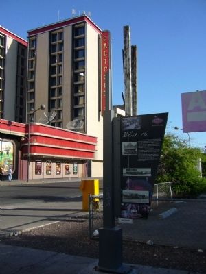
On East Ogden Avenue at North 1st Street, on the right when traveling west on East Ogden Avenue.
The notorious Block 16, North First Street between Ogden and Stewart Avenues, was the only area in the Las Vegas Townsite, outside of hotels, where liquor could be sold, starting in 1905. The block quickly changed from its original liquor and . . . — — Map (db m47859) HM
Near South 4th Street near Fremont Street, on the right when traveling north.
The Chief Hotel Court sign was originally installed around 1940 at the hotel located at 1201 E. Fremont Street. Hotel architect was A. Lacey Worshwick.
Loaned and refurbished by the Tiberti Family.
Installed as part of the Neon Museum on . . . — — Map (db m64031) HM
On West Van Buren Avenue at North E Street, on the right when traveling east on West Van Buren Avenue.
This fairy-tale residence reflects the unique family that built it, whose roots stretch back to a pioneering Utah Mormon blacksmith, ranchers in Idaho and Nevada, and railroad workers in Las Vegas.
The life of Las Vegas pioneer Lucretia Tanner . . . — — Map (db m51052) HM
On South 3rd Street, on the right when traveling south. Reported missing.
On May 15, 1905 Senator William Clark's railroad auctioned off lots to found the new town of Las Vegas. Block 20, between Second and Third and Carson and Bridger, was reserved for public purposes. In 1909 when the state legislature created Clark . . . — — Map (db m47822) HM
Built • 1927-28
Architect: Charles Alexander MacNelledge
Opened June 21, 1928
This building was Las Vegas' cultural center for many years. Its 700 seat auditorium and elegant Spanish motif lobby were used for films, plays, music recitals, . . . — — Map (db m47745) HM
On South 3rd Street, on the left when traveling south.
Building Rededication
Honoring the 100th Year
Anniversary of the First Church
Built in Las Vegas
presiding
Honorable Mayor Oscar B Goodman
December 13, 2005 — — Map (db m47756) HM
This is a two sided marker
Side A:
Standing on Fremont Street today, it's hard to visualize the canvas tents with hand-painted wooden signs that lined this dusty street and served as hotels, saloons, shops and banks in the early 1900's. . . . — — Map (db m47754) HM
This is a two sided marker
Side A:
Gaming
Like most western frontier towns, gambling was prevalent in the backrooms of early Las Vegas saloons and other establishments. From its inception as a railroad town in 1905, the citizens . . . — — Map (db m47737) HM
On F Street at West Adams Avenue, on the right when traveling south on F Street.
Black entertainers were not allowed to stay at the Strip hotels where they performed in the 1940s and 1950s. Mrs. Harrison's boarding house offered fine accommodations for many of the era's most famous stars.
During one memorable week in . . . — — Map (db m51050) HM
The following text is from a missing 2005 Centennial Marker.
Fifth Street School
This graceful Mission-Style complex was built by the federal government in 1936 to replace the Las Vegas elementary school, which burned down in 1934. . . . — — Map (db m48196) HM
On North Main Street at Fremont Street, on the right when traveling south on North Main Street. Reported missing.
This light standard was placed at the entrance to the Las Vegas Union Pacific Railroad Station in 1937. The Depot was removed in 1970 to make way for the Union Plaza Hotel. Mr. Frank Scott, Chairman of The Board of Union Plaza Hotel preserved this . . . — — Map (db m47734) HM
On South 3rd Street, on the right when traveling south.
Las Vegas was established as a railroad town in 1905; at the head of Fremont Street, the Mission-style depot represented the railroad's dominance over the economic and social life of the town for several decades. The streets of downtown were laid . . . — — Map (db m47860) HM
On South 7th Street south of East Bridger Avenue, on the right when traveling north.
The tradition of “Senior Squares” was created one night in 1941 when two students pulled a prank and painted one of the cement slabs in front of the main steps of the original Las Vegas High School. Expressing innocence the next morning when called . . . — — Map (db m203381) HM
On Jackson Avenue at F Street, on the right when traveling east on Jackson Avenue.
Commerce on the Westside was short lived, collapsing in 1905 when rival Las Vegas Townsite opened on the east side of the railroad tracks. In 1942, the Westside defined a new commercial district to serve the ethnic population of the area.
The . . . — — Map (db m51051) HM
On South 7th Street, on the right when traveling north.
Las Vegas High School
"Las Vegas Academy"
Has been placed on the
National Register
of Historic Places
By the United States
Department of the Interior
1931 — — Map (db m48197) HM
On South 7th Street, on the right when traveling north.
This is a two sided marker
Side A:
Las Vegas High School
As the population of Las Vegas increased throughout the 1920s and the construction of Hoover Dam was assured, many saw the need for a new high school. Principal Maude Frazier . . . — — Map (db m47886) HM
On North Main Street at Paiute Drive, on the right when traveling south on North Main Street.
The Bureau of Indian Affairs (BIA) bought this ten-acre site in 1911 from Helen J. Stewart, former owner of the Las Vegas Ranch, to provide a home for the Southern Paiute Indians living in and near Las Vegas. With this purchase, the government . . . — — Map (db m51055) HM
On East Carson Avenue at South 3rd Street, on the right when traveling west on East Carson Avenue.
Manneken Pis is the most widely visited and photographed statue in Belgium. While smiling coyly, he remains the emblem of the rebellious spirit of Brussels. The original Manneken Pis has been taking matters into his own hand since 1619 and has . . . — — Map (db m283761) HM
On H Street at West McWilliams Avenue, on the right when traveling north on H Street.
Created by J.T. McWilliams in 1905, the Original Las Vegas Townsite was Las Vegas' first business and residential development.
J.T. McWilliams (photo top right) was hired to do survey work in and around the Las Vegas Valley for the San Pedro, . . . — — Map (db m51048) HM
Herman Moody, Las Vegas' first black career police officer, was raised in this house at 321 Van Buren Avenue, built by his parents (father Henry Moody pictured lower left) who came here in 1939.
As first African-American in Las Vegas to make a . . . — — Map (db m51053) HM
On West Bonanza Road (Nevada Route 579), on the right when traveling west.
The first integrated hotel and casino in Las Vegas, the Moulin Rouge opened in May 1955. It is celebrated as a landmark of racial integration in Las Vegas and the United States.
Entertainers from the Las Vegas Strip and Hollywood flocked to . . . — — Map (db m51047) HM
This is a two sided marker
Side A:
Neon
Neon lighting, introduced in Paris in 1910, offered a brilliant, and efficient, alternative to the incandescent light bulb. In the United States, neon's popularity soared, used to advertise . . . — — Map (db m47755) HM
On East Ogden Avenue at North Casino Center Boulevard ( Route 602), on the right when traveling north on East Ogden Avenue.
Opened in 1937 at 5th Street (Las Vegas Boulevard) and Garces, the Nevada Motel was the first auto court in Las Vegas to identify itself as a "motel". In its last years in business it operated in conjunction with the Sweetheart Wedding Chapel next . . . — — Map (db m64028) HM
On South Main Street at Garces Avenue, on the right when traveling north on South Main Street.
On this site stood "Old Betsy," Las Vegas' first electric generator, which serviced the power needs of the new town. The generator, operated by the Consolidated Power and Telephone company, supplied electricity from 1906-1916. The company evolved . . . — — Map (db m47867) HM
On 400 S. 7th Street at Stanley W Cooper Pl, on the right when traveling south on 400 S. 7th Street.
Charles "Pop" Squires, often referred to as "the Father of Las Vegas" lived at this location, with his wife, Delphine, from 1931 until his death 1958.
Squires first arrived in the Las Vegas Valley in February 1905. He and his partners . . . — — Map (db m131061) HM
On South 4th Street at Lewis Avenue, on the right when traveling north on South 4th Street.
With gratitude to the Engelstad Family Foundation for its generous contribution to this Liberty Bell monument, and in recognition of the life and achievements of Ralph Louis Engelstad who personified the highest qualities of personal liberty. Just . . . — — Map (db m47828) HM
On North Las Vegas Boulevard at East McWilliams Avenue, in the median on North Las Vegas Boulevard.
The Silver Slipper was originally installed on the grounds of the Last Frontier on Las Vegas Boulevard.
The Slipper was designed by Jack Larsen and built by Young Electric Sign Company. — — Map (db m92469) HM
On South Casino Center Boulevard at East Bridger Avenue, on the right when traveling north on South Casino Center Boulevard.
Organized on 4 October 1908, St. Joan of Arc is the oldest Catholic Parish in Las Vegas. The first church, known as “Cottage Chapel,” was dedicated in 1910 and rebuilt at least twice before the present structure was erected. A memorial to the . . . — — Map (db m203385) HM
Near East Ogden Avenue south of North Casino Center Boulevard, on the right when traveling east.
The Flame Restaurant sign was originally installed in 1961 on the roof of the restaurant at #1 Desert Inn Road.
Restored through a generous donation from Rich Travis.
Installed as part of the Neon Museum on July 8, 1997
Believed to . . . — — Map (db m64029) HM
Near Bridger Avenue, on the right when traveling west.
The Morelli House is a classic example of Las Vegas, mid-century residential architecture. It was built in 1959 by the Sands Hotel orchestra leader, Antonio Morelli, and his wife Helen. Originally located at 52 Country Club Lane in the former . . . — — Map (db m69450) HM
On East Stewart Avenue at North Third Street on East Stewart Avenue.
This property
has been placed on the
National Register
of Historic Places
by the United States
Department of the Interior
United States Post Office
and Courthouse
c.1933 — — Map (db m47746) HM
On South First Street, on the right when traveling north. Reported missing.
As a founder of one of the pioneer families of Las Vegas, Ed Von Tobel came to the 1905 Las Vegas land auction and purchased a lot. He established a lumber company on Main Street in 1905 and then moved to this site in 1906. The hardware business . . . — — Map (db m47879) HM
On South 4th Street just south of Lewis Avenue, on the right when traveling north.
Delphine Squires and the Mesquite Club sponsored suffrage speakers 1912-1914. Club met at the Las Vegas school on this site until 1915. — — Map (db m213132) HM
The first school in West Las Vegas opened with two rooms and two teachers for four grades.
From 1904 until 1923, children from McWilliams' Townsite crossed the railroad tracks to get to school in Clark's Townsite. This dangerous situation . . . — — Map (db m51054) HM
On North Las Vegas Boulevard, on the right when traveling north.
Opened in 1914 on ten acres of donated land, the cemetery was the unofficial veterans cemetery until 1989 and is the home of Veterans Memorial Circle
Woodlawn Cemetery
Is listed on the
National Register
of Historic Places — — Map (db m75589) HM
On North Las Vegas Boulevard at Foremaster Lane on North Las Vegas Boulevard.
Until 1914, when the railroad donated land for a city cemetery, people buried the dead in small family plots or on public land just north of the railroad-owened Las Vegas Ranch, east of Las Vegas Boulevard.
In pre-railroad times, the Paiute . . . — — Map (db m51056) HM
On East Fremont Street 0.1 miles east of East Charleston Boulevard, on the right when traveling east.
Opened around 1931 by Mrs. Mattie "Jimmy" Jones, the Green Shack restaurant was a town landmark at this site. The restaurant opened in a Union Pacific Railroad barracks building that was moved here; in 1934 additions were made to the structure. . . . — — Map (db m312062) HM
On East Charleston Boulevard at South 8th Street, on the right when traveling east on East Charleston Boulevard.
The City of Las Vegas Mayor and City Council
presents
An Art in Public Places Project by The City of Las
Vegas Arts Commission
In celebration of the Las Vegas Centennial
Sculpture by Steven Liguori
"Breaking Ground"
This 14' high . . . — — Map (db m47890) HM
On South Maryland Parkway at Jessica Avenue, on the left when traveling north on South Maryland Parkway.
Las Vegas' first tract subdivision, the Huntridge neighborhood was erected between 1941 and 1944 on land purchased in the 1920s by international businessman Leigh Hunt. After his death in 1931, Hunt's widow sold off large chunks of land. In December . . . — — Map (db m47893) HM
On E. Charleston Blvd., on the left when traveling west.
The Wengert residence was originally owned by Cyril S. and Lottie Wengert. Built in 1938, this Tudor Revival home was designed by Architect, H. Clifford Nordstrom, and was amongst the largest in Las Vegas. Prominent in Las Vegas social and business . . . — — Map (db m271054) HM
On H Street at Morgan Avenue, on the left when traveling south on H Street.
St James has been a vital force in meeting the needs of this underserved, segregated but expanding community.
The second Catholic Church in Las Vegas, St. James opened in 1940 in a small concrete building at H and Morgan streets (pictured . . . — — Map (db m51049) HM
Near Thom Boulevard, on the right when traveling north.
John and Lois Mull moved to Las Vegas in 1936 from Pennsylvania. John was a carpenter and initially worked in construction, before becoming a butcher in the 1940s. In the early 1950s he acquired this property and in 1953 he started his first meat . . . — — Map (db m293640) HM
Near South Maryland Parkway north of East Russell Road.
A tribute to Siegfried Fischbacher and Roy Horn, known as Siegfried and Roy Masters of the Impossible.
Born in Germany, proud American citizens, as illusionists they brought magic to Las Vegas.
As conservationists, they protect . . . — — Map (db m193114) HM
Near Las Vegas Boulevard South at Russell Road, on the right when traveling north.
The Little Church of the West, built 1942, has been placed on the National Register of Historic Places by the United States Department of the Interior. — — Map (db m29215) HM
On Las Vegas Boulevard South 0.4 miles south of Russell Road, in the median.
The Welcome To Las Vegas Sign - 1959 - has been placed on the National Register of Historic Places by the United States Department of the Interior.
The Welcome to Fabulous Las Vegas sign debuted on the Las Vegas Strip in 1959 and today . . . — — Map (db m29216) HM
Near South Valley View Boulevard north of Alta Boulevard.
Seemingly Built Overnight
There wasn't much in the way of services for the hardy souls who chose to settle here in 1905, but Las Vegas changed rapidly in these early years.
Residents quickly went to work, establishing new . . . — — Map (db m286216) HM
Near South Valley View Boulevard at West Charleston Boulevard.
1905 - 1908
City of Las Vegas
Diamond Jubilee
From within this area flowing artesian springs and wells provided the lifeblood to the valley and it settlers.
This abundant supply of water has been the most important asset in the . . . — — Map (db m47888) HM
Near South Valley View Boulevard north of Alta Boulevard.
Auger
This auger was used during the Intake No. 3 project
to tunnel under Lake Mead.
A tunnel boring machine (TBM) slowly drilled under the lake
to connect with an intake structure 3 miles out in the
lakebed. This auger moved rock . . . — — Map (db m286211) HM
On South Valley View Boulevard north of Alta Boulevard.
The famous Las Vegas Springs rose from the desert floor here, sending two streams of water across the valley to nurture the native grasses, and create lush meadows in the valley near Sunrise Mountain. The natural oasis of meadow and mesquite forest . . . — — Map (db m131317) HM
Near South Valley View Boulevard north of Alta Boulevard.
The Wild West Grows at a Wild Pace!
In 1905, a few hundred people were
living in Las Vegas and the town consisted of approximately 110 acres of
developed land. By 1920, the town's
population more than doubled to
about 2,300 . . . — — Map (db m285970) HM
Near South Valley View Boulevard north of Alta Boulevard.
Between 1909 and 1911, the San Pedro,
Los Angeles and Salt Lake Railroad constructed
64 railroad cottages in downtown Las Vegas to
house railroad workers and their families.
The cottages came in four- and five-room floor
plans, and . . . — — Map (db m285968) HM
Near South Valley View Boulevard north of Alta Boulevard.
Derricks dotting the landscape are a
testament to the importance of water
in the establishment and growth of
Las Vegas. In the early 1900s, the Las
Vegas Springs made this valley an ideal
location for a railway station and new
town. Steam . . . — — Map (db m285861) HM
Near South Valley View Boulevard north of Alta Boulevard.
The Biggest of the Big
The clump of vegetation up ahead
marks the place where abundant
water once bubbled in a "cauldron
pool" spring.
This "Big Spring" was (not surprisingly)
the largest of a group of artesian
springs . . . — — Map (db m285934) HM
Near White Rock Loop, on the right when traveling west.
A Time For Feasting And Ceremony
The circular area of fire-cracked limestone and darkened ash is a very old agave roasting pit.
Dug by Native People, including the Nuwuvi (Southern Paiute), this roasting pit was lined with flat rock. . . . — — Map (db m287127) HM
On Tule Springs Road, on the right when traveling north.
Tule springs is one of the few sites in the United States where evidence suggests the presence of man
before 11,000 B.C.
Scientific evidence shows this area, once covered with sagebrush and bordered with yellow-pine forests,
had . . . — — Map (db m29960) HM
On Twin Lakes Drive 0.1 miles south of West Washington Avenue, on the left when traveling south.
Lorenzi Lake, the dream of pioneer David G. Lorenzi, opened as a private resort in 1926, became the Twin Lakes Lodge in the 1940s, and a public park in 1966.
Arriving in southern Nevada in 1911, Lorenzi began building his park on 80 acres . . . — — Map (db m51044) HM
The three buildings on the site were constructed in 1949 as a part of Twin Lakes Lodge, a dude ranch surrounded by stables, a lake, rodeo grounds and a natural springs.
The buildings are on a portion of the 80 acre Lorenzi Resort originally . . . — — Map (db m69454) HM
On East Flamingo Road near University Center Drive, on the right when traveling east.
US Senate Resolution 151
Whereas hundreds of thousands of men and women have served this Nation in building its
nuclear defense since World War II.
Whereas these patriotic men and women deserve to be recognized for their . . . — — Map (db m284393) HM
On West Bonanza Road at North Tonopah Drive, on the right when traveling west on West Bonanza Road.
Colorful Horseshoe Club owner Benny Binion and his family lived here from 1947 to 1989.
Originally built in 1942 by service station owner C.A. Morehouse, the home was one of the largest in Las Vegas with three bedrooms, several baths, a . . . — — Map (db m51045) HM
On West Bonanza Road (State Highway 579) at Clarkway Drive, on the right when traveling west on West Bonanza Road.
Here in the 1930s and 1940s, Korean immigrant Frank Kim raised melons, tomatoes, and onions. His devoted son, Frank Kim, Jr. became a pillar of the community.
From the early days of Las Vegas, Asian [...] considerable skill to make poor desert . . . — — Map (db m51046) HM
Few children traveled with the regular Spanish Trail caravans. The journey was long and dangerous. Young children were a burden and older ones were needed at home. Before 1841, families with children rarely moved to California. Those who mode the . . . — — Map (db m241715) HM
In 1843-1844 Capt. John C. Fremont explored the West. He named the Old Spanish Trail and the Great Basin - a vast region whose rivers drained inland, not to the sea. He first trekked to Oregon, then south through California, then back eastward . . . — — Map (db m241714) HM
Spanish Trail caravans wound between watering holes across the Mojave Desert. Mormon wagon trains followed much of the Spanish Trail, but since wagons could haul water and feed, this opened up short-cuts. The railroad broke new ground by building . . . — — Map (db m241717) HM
Life in the Las Vegas Valley in the 19th Century revolved around three ranches owned by O.D. Gass/Archibald Stewart, Conrad Kiel and Jim Wilson.
The Gass/Stewart Ranch (1865-1905) was built on land developed earlier by the Mormons. The . . . — — Map (db m241716) HM
For centuries before the Spanish arrived in the Southwest, native peoples traded goods across the network of routes that became the Old Spanish Trail. The Spanish called all the first people "Indians", later identifying them as Pueblos, Apaches, . . . — — Map (db m241719) HM
For more than 150 years this ten-acre parcel preserved the ruts of the Old Spanish Trail between Las Vegas Springs and Mountain Pass.
When Spain owned the Southwest, Santa Fe and Los Angeles were the only two centers of government and . . . — — Map (db m241707) HM
On South Cimarron Road, on the right when traveling north.
Spanish Trail routes crossed deserts and mountain ranges far from Mexican settlements and government authorities. Horses and mules were in short supply to conduct the Santa Fe-Missouri trade opened in 1821 by Americans from Missouri. Outlaws and . . . — — Map (db m241725) HM
On South Cimarron Road at Eldora Avenue, on the right on South Cimarron Road.
By 1855 wagon roads linked Utah to California. To ease the long trip between Los Angeles and Salt Lake City, the LDS church established an outpost at an oasis called, Las Vegas, along the Old Spanish Trail/Mormon Road.
Thirty missionaries . . . — — Map (db m241723) HM
The most dangerous section of the Old Spanish Trail crossed the Mojave Desert; it is extremely hot in the summer and without major rivers running through it. Springs and the Amargosa River (which drains into Death Valley) made it possible to . . . — — Map (db m241722) HM
During the Mexican War, Mormon men served as a special battalion in the U.S. Army. They left lowa in July 1846 and marched through the Southwest to San Diego, building roads and American outposts along the way. They fought the Battle of San . . . — — Map (db m241721) HM
Spanish Trail travelers through Clark County followed changing routes as they learned shortcuts and new sources of water, but the trail always connected watering holes. Spanish Trail pioneer Antonio Armijo and early fur trappers depended on the . . . — — Map (db m241712) HM
On South Casino Drive south of the Laughlin Bridge to Arizona (Route 163), on the right when traveling north.
American Legion Post No. 60 Laughlin-Nevada proudly designates this Avenue of Flags in honor of all those who served honorably in the Armed Forces of the United States, protecting our country and assuring us that our flag will forever wave. . . . — — Map (db m37279) HM
Near South Casino Drive, on the right when traveling south.
After the United States government's successful experiment with camels in the west in 1857, entrepreneurs saw possibilities in the ungainly beasts for carrying supplies. In addition to the government's camels, which were sold off by 1864, two . . . — — Map (db m78520) HM
On South Casino Drive near the Laughlin Bridge to Arizona (Route 163), on the right when traveling south.
Pioneer and Founding Father of the Town of Laughlin. His vision in 1966 of the opportunities and growth for this area is what you see today. — — Map (db m37278) HM
On Avi Casino Drive 1.8 miles west of Needles Highway, on the left when traveling north.
In first times, there was chaos, and from the union of earth and sky was born the Great Spirit Matavilya.
Before he could teach his people all they needed to know about their world, he was killed by his sister, Frog Woman. It was then that his . . . — — Map (db m40308) HM
Near South Casino Drive, on the right when traveling south.
During the building of Davis Dam, the Nevada side of the river here became known as Tristate. In 1964, Don Laughlin was looking for an investment opportunity. He had sold his 101 Club in North Las Vegas, and flew over a closed saloon and motel . . . — — Map (db m46732) HM
On Nevada Route 163 at milepost 8, on the right when traveling east. Reported missing.
In 1855 Congress authorized $30,000 for camels as frontier military beast of burden because of their adaptability to desert heat, drought, and food.
Lt. Edward F. Beale surveyed the wagon route from Fort Defiance, New Mexico, to the Colorado . . . — — Map (db m32822) HM
On Needles Highway (at milepost 5), 2 miles south of West Casino Drive, on the right when traveling south.
Seeking to open a land route between the Missions of Sonora and California, Fray Francisco Hermenegildo Garcés, OFM, a Franciscan Missionary priest and explorer, was the first European to enter the present boundaries of Nevada. He departed Mission . . . — — Map (db m84277) HM
On West Mesquite Boulevard, on the right when traveling west.
On this site was one of the first rest-over businesses in the Virgin Valley. Here an early version of an adobe brick house was used as a small grocery store with a separate wash house that had shower and laundry facilities, and a way station . . . — — Map (db m46745) HM
On East 1st North at North Sandhill Boulevard, on the left when traveling east on East 1st North.
Abram Woodbury, one of the first permanent settlers in Mesquite, built a new home here circa 1919 and opened a mercantile store. He also built overnight cabins for tourists and operated Mesquite's first gas station. Abram purchased gasoline by the . . . — — Map (db m46762) HM
On Hughes Avenue, on the right when traveling north.
Circa 1901"We lived in a lumber granary and the old rock house. We traded for this lot and built a sixteen-foot square room. I borrowed Jim's team and wagon and worked at the sawmill to get lumber for our first home." It was braced on rocks and . . . — — Map (db m46764) HM
On East 1st North, on the right when traveling east.
Charles Hardy, one of the first settlers in Mesquite, used lumber he brought back from Mt. Trumbull and local adobe to build the original large central room of his home – the other rooms were added later. The room was used as a bedroom, living . . . — — Map (db m46941) HM
On East 1st South, on the right when traveling east.
This site was the location of the first commercial dairy in Mesquite, which began operating circa 1941. The barn was used by over twenty families in the community. According to a schedule, they would drive their cows to the barn twice a day to milk . . . — — Map (db m46743) HM
On North Sandhill Boulevard, on the right when traveling north.
In the 1940's the place to go was Leonard Patty's soda fountain and drug store. This was the first soda fountain in town and served up all the favorites for quenching thirst in those days, including phosphates and sodas of all varieties – . . . — — Map (db m46763) HM
On West Mesquite Boulevard, on the right when traveling west.
The Egg Association formed circa 1929 as a local cooperative, selling and distributing local eggs to tourist oriented businesses, or to market in Las Vegas. High school boys studying agriculture were part of the enterprise. The Association built a . . . — — Map (db m46746) HM
On East Mesquite Boulevard, on the right when traveling east.
This adobe brick building was built by Deloy Abbott circa 1932. Behind the house was another adobe building used as a chicken coop. Ervin Jones purchased the home in 1941 and lived here until his death. The house was later converted to a business. — — Map (db m46741) HM
On Mesquite Boulevard, on the right when traveling east.
Mesquite proved a total failure after several years labor. And today only a few ravines and sand-filled ditches mark the place where the village once stood. —LDS Church Historian Andrew Jensen, 1891.
The remoteness of the area, . . . — — Map (db m1448) HM
On East 1st North, on the left when traveling east.
John Pulsipher purchased the Tent School (Marker #9) and moved it across the street to this location to use as a residence. The following year he built a large adobe brick one-room house with walls three adobes thick. The tent was then converted to . . . — — Map (db m46747) HM
On Mesquite Boulevard, on the right when traveling east.
… from weary travelers to women and their children who would come to visit … she never turned anyone away without feeding them. She would invite you to eat and then say ‘There’s plenty such as ’tis; … Bless her heart, it was as big as al . . . — — Map (db m1466) HM
On West Mesquite Boulevard, on the right when traveling west.
Library
Circa 1941
The museum building started as a library and was one of only two National Youth Administration (NYA) projects in Nevada. Volunteers finished the building when NYA funds were diverted to the war effort. Clark . . . — — Map (db m46744) HM
On East 1st North, on the right when traveling east.
This is the oldest standing house in Mesquite and was continuously used as a residence from 1894 until 2003. The original portion of the house dates from circa 1880 occupation when Mesquite Flats was temporarily settled. The large rocks made the . . . — — Map (db m46748) HM
On First North Street, on the right when traveling south.
Public Square, Circa 1894 • Tent Chapel and School, circa 1899.
When Mormon settlers came to Mesquite Flats in 1894, they designed the southeast corner of this block as the Public Square. It was a place where the community gathered for many . . . — — Map (db m1412) HM
Stretching for 130 miles across Clark County, this historic horse trail became Nevada’s first route of commerce in 1829 when trade was initiated between Santa Fe and Los Angeles. The trail was later used by the wagons of the “49ers” and . . . — — Map (db m1414) HM
On East Mesquite Boulevard, on the right when traveling west.
Tithing Lot
Circa Late 1890s.
The southeast quarter of this block was originally owned by the Church of Jesus Christ of Latter Day Saints and was used as a tithing lot. Church members paid tithing in-kind donations of fruit, crops, etc., . . . — — Map (db m1282) HM
On West Mesquite Boulevard (Nevada Route 144) at Yucca Street, on the right when traveling west on West Mesquite Boulevard.
Virgin Valley was traveled by Jedediah Smith in 1826 and by Fremont in 1844.
The valley served as the right-of-way for the Old Spanish Trail (1829-1848) and for the Mormon road or southern route of travel to southern California.
The areas . . . — — Map (db m1279) HM
On East Mesquite Boulevard east of North Sandhill Road, on the right when traveling east.
This is a two-story adobe building with a rock foundation. The walls are three adobes thick and there are six rooms on each floor. Abbott served as Bishop of the local congregation of the Church of Jesus Christ of Later-day Saints for 27 years. His . . . — — Map (db m46740) HM