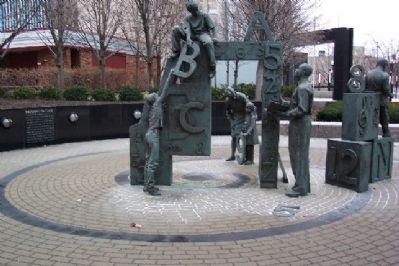
On Broad Street at 5th Street, on the right when traveling east on Broad Street.
Is the first park developed specifically to honor Ohio's public educators. It was created by members and friends of the State Teachers Retirement System of Ohio as part of the system's 80th anniversary celebration. Included in the park are the names . . . — — Map (db m14491) HM
On Belle Street north of West State Street, on the right when traveling south.
Dorrian Green is named in honor of Franklinton native Hugh J. Dorrian, a dedicated and unwavering public servant to the residents of Columbus for 52 years. Mr. Dorrian served as the city's fiscal guardian from 1966 through 2017, first as Columbus . . . — — Map (db m296313) HM
On Lower Scioto Greenway north of Washington Boulevard, on the right when traveling south. Reported damaged.
Evolution of the Scioto River
A Brief History:
At over 231 miles long, the Scioto River bisects half the longitude of the State of Ohio. The river has historically served as fertile hunting grounds for several Native American tribes, a . . . — — Map (db m296322) HM
On West Long Street west of Marconi Boulevard, on the right when traveling east.
A Brief History:
At over 231 miles long, the Scioto River bisects half the longitude of the State of Ohio The river has historically served as fertile hunting grounds for several Native American tribes a navigational tool for European . . . — — Map (db m203903) HM
On Washington Boulevard 0.1 miles south of West Broad Street (U.S. 40), on the left when traveling south.
Lucas Sullivan
1765 - 1823
Founder of Franklinton, where Columbus began.
The Great Flood of 1913
The 1913 flood was Columbus' most tragic disaster. Three days of rain began Easter Sunday, March 23, 1913, dropping six inches on the . . . — — Map (db m296316) HM
On South High Street at West Mound Street, on the right when traveling south on South High Street.
Side A
Johann Christian Heyl (1788-1877), the first German and first Lutheran to settle in Columbus, was one of the original 15 settlers of the city. A baker by trade, Heyl came to bake for the soldiers quartered in Franklinton during the . . . — — Map (db m94617) HM
On West Long Street (U.S. 33) west of Marconi Boulevard.
On this spot the first cabin
in Columbus
was built by its first inhabitant
John Brickell 1797
Born Stewarts Crossing, Penn. 1781.
Captured by a Delaware Indian 1791.
Adopted by chief of that tribe
Whingwy . . . — — Map (db m59319) HM
On Long Street at Jefferson Avenue, on the right when traveling east on Long Street.
The King Lincoln District was established in July 2002 to honor the historic heart and soul of Columbus’ African American community. This arch, welcoming all to the King Lincoln District, is dedicated to our shared history and our commitment to the . . . — — Map (db m16965) HM
On West Long Street (U.S. 33) west of Marconi Boulevard, on the right when traveling east.
In 1992, the national floral show known as Ameriflora came to Columbus and was featured at Franklin Park on the near east side. The Central Ohio AFL-CIO incorporated an area of the park to honor workers killed in the work Place. A small grove of . . . — — Map (db m203904) HM
On Marconi Boulevard south of West Long Street (U.S. 33), on the right when traveling south.
This site was the location of a children's park and fountain, dedicated in 1992, made possible with major contributions from members of the builders exchange of central Ohio and individual donors whose names were memorialized on bronze plaques. . . . — — Map (db m203884) HM
On East State Street at South 5th Street, on the right when traveling east on East State Street.
In 1920, a writer for the Architectural Forum wrote about this rambling structure. “To find an interesting piece of architecture in a medium size, Middle West town was likened to chancing
on an oasis in a none-too-fertile country.” He . . . — — Map (db m309309) HM
On Broad Street (U.S. 40) at the west bank of the Scioto River, on the right when traveling west on Broad Street.
Named and Dedicated Oct. 31-1921
by Columbus Camp No. 49
United Spanish War Veterans
to the memory of all persons
from Franklin County who
served in the World War — — Map (db m31393) HM
Near Belle Street north of West Broad Street (U.S. 40), on the right when traveling north.
This Memorial Garden is a sanctuary for remembrance and reflection.
A grove of American Elms, a tree which has sheltered veterans and their families since colonial times, provides a place for rest and relaxation.
The limestone wall . . . — — Map (db m201037) WM
On Marconi Boulevard south of West Long Street (U.S. 33), on the right when traveling north.
Author's Note:
It is wise to remember the ancient people before us who greeted new things to this continent. How did they teach children to prepare for real change holding to virtue as they discovered the voyagers? The hero of this fantasy, . . . — — Map (db m204180) HM
On Belle Street at West Capital Street, on the right when traveling north on Belle Street.
The land that was discovered by the early settlers in Ohio was composed of large expanses of forests, with scatterings of small and large prairie openings. Today only fragments of those prairies remain, but those beautiful grasses and wildflowers . . . — — Map (db m296314) HM
Near Belle Street north of West Broad Street (U.S. 40), on the right when traveling north.
Honoring all veterans past, present and future
My stone is red for
The blood they shed
The medal I bear
Is my country's way
To show they care.
If I could be seen
By all mankind
Maybe peace will
Come in my . . . — — Map (db m201038) WM
On Belle Street south of West Chapel Street, on the left when traveling south.
Science Spectrum
dedicated to the memory of
Roy L. Shafer 1951 - 2005
COSI President & CEO 1983-1995
Director of Development & Marketing 1980-1983
Camp-In Director 1970-1980
Summer & Weekend Staff 1967-1970
Student . . . — — Map (db m296331) HM
On South High Street south of East Main Street (U.S. 62), on the left when traveling south.
This building has been placed on the
National Register of Historic Places
by the United States Department of
the Interior. Originally built by
Nickolas Schlee and Charles Kemmler,
it is significant for its many
outstanding architectural . . . — — Map (db m248279) HM
On Belle Street south of West Chapel Street, on the left when traveling south.
The kinetic sculpture celebrates Isaac Newton's discovery that sunlight, or white light, is made up of the whole range of colors that our eyes can detect. We can see this visible spectrum of colors when sunlight bends through raindrops to form a . . . — — Map (db m296330) HM
On this site, the Scioto River has been spanned by at least six bridges, all of which have been important to the growth of Columbus, Ohio's state capital.
1816 • A wooden toll bridge was built by Franklinton developer Lucas Sullivant.
1826 • . . . — — Map (db m31427) HM
On Broad Street (U.S. 40) at 5th Street, on the right when traveling east on Broad Street.
Dave Thomas realized his boyhood dream when he opened his first hamburger restaurant on this site on November 15, 1969. Thomas changed the image of fast food by serving fresh, not frozen hamburgers, hot off the grill with a choice of toppings in a . . . — — Map (db m14492) HM
On West Broad Street north of West Broad Street (U.S. 40), on the right when traveling north.
Our debt to the heroic men and the valiant women in the service of our country can never be repaid. They have earned our undying gratitude. America will never forget their sacrifices.
- Harry S. Truman — — Map (db m201039) WM
On East Broad Street (U.S. 40) at North Fifth Street, on the right when traveling west on East Broad Street.
St. Joseph Cathedral
November 11, 1866, the cornerstone
of St. Joseph Cathedral was laid at the
N.W. corner of E. Broad and 5th Sts. The
beautiful gothic structure was
completed n 1872. The consecration
service took place October 20, 1878,
a . . . — — Map (db m98924) HM
On Long Street at Jefferson Avenue, on the right when traveling east on Long Street.
Organized in 1823 as Bethel African Methodist Episcopal Church, St. Paul A.M.E. Church is the oldest congregation of African descent in Columbus. The church, founded by Moses Freeman and 13 other members from the Town Street Church, was originally . . . — — Map (db m16963) HM
On State Street at 6th Street, on the right when traveling east on State Street.
This site, now Grant Medical Center, was the original location of the neo-gothic building that housed St. Francis Hospital and Starling Medical College, named for Columbus benefactor Lyne Starling. Established in 1849, Starling Medical College/St. . . . — — Map (db m12926) HM
Near Wolfe Drive north of West Town Street, on the right when traveling north.
Stegosaurus Stenops
Nickname: "Dale
Unlike other dinosaurs represented here, Stegosaurus lived during the Late Jurassic period, more than 145 million years ago. McCauley created this sculpture at COSI in June 2016. . . . — — Map (db m296333) HM
On East Main Street (U.S. 62) at South High Street, on the right when traveling east on East Main Street.
"Fireproof" was an important word to the Columbus business community. Between 1889 and 1893, five downtown Columbus theaters were constructed and destroyed by fire. These fires also claimed the Seneca, Deshler, and Vendome hotels and resulted . . . — — Map (db m203909) HM
On Washington Boulevard east of Belle Street, on the right when traveling east.
The first Main Street Bridge was a seven-span, reinforced concrete, open spandrel arched bridge with an overall length of 638 feet. It was constructed between 1935 and 1937 at a cost of approximately $500,000. The bridge was . . . — — Map (db m296311) HM
Construction began December 1930 in the administration of Governor Meyers Y. Cooper and was completed February 1932 in the administration of Governor George White.
This site was chosen and this building erected by the Ohio State Office . . . — — Map (db m214653) HM
On Long Street (U.S. 33), on the left when traveling east.
The confluence of the Scioto and Olentangy Rivers is just northwest of North Bank Park, and the rivers were the major attraction for both Native American and white settlers. The river and its tributaries were the life-blood to the region providing . . . — — Map (db m29966) HM
Near Broad Street (U.S. 40) at Starling Street, on the right when traveling east.
Toledo and Ohio Central Railroad Station
The only remaining Columbus railroad station, The Toledo & Ohio Central (T&OC) Railroad Station was constructed in 1895 and was the departure point for William McKinley when he left for Washington D.C to . . . — — Map (db m13067) HM
On Rich Street (U.S. 62) at Washington Blvd, on the right when traveling west on Rich Street.
The second Town Street Bridge, a closed spandrel concrete arch bridge, crossed the Scioto River at this location from 1921 to 2009. The bridge was designed by the firm of Braun, Fleming and Knollman, and was built by the D. W. McGrath and Sons . . . — — Map (db m107965) HM
On Washington Boulevard north of West Rich Street, on the left when traveling south.
The Town Street Bridge railing consists of one large recessed limestone panel over each of the concrete piers and abutments, and the remainder of the railing consists of 11 urn-shaped balusters between the small square limestone columns and . . . — — Map (db m296329) HM
Near West Broad Street north of West State Street, on the left when traveling south.
Triceratops Horridus
Nickname: "Roland"
Triceratops lived during the Late Cretaceous period, more than 66 million years ago. It used its horns to attract mates. McCauley welded these parts together in snow and . . . — — Map (db m296332) HM
On Long Street (U.S. 33) at Neil Avenue, on the left when traveling east on Long Street.
William Neil and his wife Hannah Schwing Neil each played significant roles in the early development of Columbus.
William was a large, outgoing, and ambitious man determined to make a fortune. His first successful business was a tavern on High . . . — — Map (db m29957) HM
On Long Street (U.S. 33), on the right when traveling east.
William Green Labor Leader
A native of Coshocton County, William Green (1870-1932) began his working life as a coal miner at age 16 and rose rapidly in the leadership of the United Mine Workers of America. Twice elected to the Ohio Senate, . . . — — Map (db m12970) HM
On Long Street (U.S. 33), on the left when traveling east.
The history of a city is found not only in its grand old houses, but also in its neighborhoods. While Columbus has its share of grand houses, most residents did not live that lifestyle. Many working class people lived in hotels, apartments, . . . — — Map (db m30002) HM
Dedicated November 11, 2006 to the men and women of Franklin County Ohio that served our country bravely and honorably so our freedoms endure.
The sacrifices of few ensured the freedom of many. A grateful community remembers those who served in . . . — — Map (db m13487) WM
On Virginia Lee Rd at South Virginia Lee Rd, in the median on Virginia Lee Rd.
A Brief History of Eastmoor
In 1798, Articles of Confederation Congress provided land to British Canadians who lost property because of loyalty to American revolutionaries during the American War of Independence (1775-1783). This land was . . . — — Map (db m94626) HM
On Main Street Old National Road (U.S. 40), on the right when traveling east.
Eastmoor, one of nine (9) Columbus neighborhoods on the National Road, was built on part of the land established by Congress in 1798 as the “Refugee Lands” and given to British Canadians who supported the American colonists during the . . . — — Map (db m135243) HM
On East Livingston Avenue 0.1 miles east of Barnett Road, on the left when traveling east.
Livingston Heights Place. Dr. Harley Manuel and Charles E. Jones were frustrated by the restrictive covenants and redlining that kept Black residents from purchasing homes in desirable Columbus neighborhoods. Deciding to create their own . . . — — Map (db m295609) HM
In November 1967, the Ohio Quarter Horse Association hosted a three-day American Quarter Horse show at the Ohio State fairgrounds that drew more than 5,000 people. They could not have known that this horse show would grow to become the largest . . . — — Map (db m2047) HM
On East 11th Avenue at Essex Avenue, on the right when traveling north on East 11th Avenue.
Clone of Johnny Appleseed tree at the Governor's Residence Heritage Garden.
This tree is a descendant of a tree planted by John Chapman, known as Johnny Appleseed, around 1837 in Ohio. — — Map (db m280887) HM
Near History Street north of East 17th Street, on the left when traveling north.
The school board has purchased this basket ball and goal hoop in the hopes that the village youth will avail themselves in the opportunity to become physically fit and mentally alert:
Dr. James Naismith's
Original 13 Rules of . . . — — Map (db m201031) HM
On East 11th Avenue at Essex Avenue, on the right when traveling north on East 11th Avenue.
The ground beneath you is comprised of several different layers of sediments and rocks that tell a small part of the story of Ohio's geology Explore the rest of the story along the Geological Walk Through Time. To help you along, we've provided a . . . — — Map (db m280877) HM
On East 11th Avenue at Essex Avenue, on the right when traveling west on East 11th Avenue.
Did you know Bison used to live in Ohio? They'd graze in the prairies and trample vegetation as they moved, which helped keep prairie habitats open and sunny. To get to their food and water, bison traveled along the same trails each year, which . . . — — Map (db m280891) HM
On East 11th Avenue at Essex Avenue, on the right when traveling north on East 11th Avenue.
The Natural Resources Park Buckeye Grove is composed of a collection of buckeye tree species, including Ohio buckeye, the state's official tree.
The monument displayed here was designed for the 1958 Ohio State Fair and was moved to this location . . . — — Map (db m280875) HM
On East 11th Avenue at Essex Avenue, on the right when traveling north on East 11th Avenue.
These eight Buckeye Trees planted during the 1958 Ohio State Fair honoring Ohio's eight presidents:
William Henry Harrison 1841-
Ulysses S. Grant 1869-1877
Rutherford B. Hayes 1877-1881
James A. Garfield 1881-
Benjamin Harrison 1889-1893 . . . — — Map (db m280876) HM
Near History Street north of East 17th Street, on the left when traveling north.
Coal Car. This coal car was used in the 1920s and the American Electric Power office in Lancaster, Ohio, donated it to the Ohio Historical Society in 1985.
Double Water Wheel Turbine. This double water wheel turbine, dated 1913, is . . . — — Map (db m201007) HM
On Big 4 Street at East 11th Street, on the right when traveling east on Big 4 Street.
Soil from Ohio's eighty-eight counties surrounds the roots of this living monument to the "people of the land"- Ohio's farmers. Donated by the Ohio Nurserymen's Association this tree was planted during the Ohio Farm Bureau Bicentennial Family Day, . . . — — Map (db m280870) HM
On East 11th Avenue at Essex Avenue, on the right when traveling north on East 11th Avenue.
Flint is a variety of chert, a rock composed of extremely tiny crystals of the mineral quartz. Flint is hard, and owing to the way it fractures, it can be worked (knapped) to form sharp edges. Ohio flint was especially prized by Native Americans, . . . — — Map (db m280881) HM
On East 11th Avenue at Essex Avenue, on the right when traveling north on East 11th Avenue.
A geologic cross section depicts the distribution of rock layers in Ohio as being like the layers of a cake. This cross section traverses from the Ohio-West Virginia boundary at Belpre, Ohio, to Bellefontaine, then to the Michigan-Indiana-Ohio . . . — — Map (db m280879) HM
On East 11th Avenue at Essex Avenue, on the right when traveling north on East 11th Avenue.
Production of grindstones was big business in Ohio during the 1800s and early 1900s, when they were shipped all over the world. The large grindstone here was cut from Permian-age sandstone in the vicinity of Marietta, Washington County. The best . . . — — Map (db m280882) HM
On East 17th Avenue at Clara Street, on the right when traveling east on East 17th Avenue.
The Gyr, originated in West India, is a breed of zebuine cattle. It is distinctive in appearance, typically having a rounded and domed forehead (being the only ultraconvex breed in the world), long pendulous ears and horns which spirallout and back. . . . — — Map (db m282707) HM
On East 11th Avenue at Essex Avenue, on the right when traveling north on East 11th Avenue.
The history of trapping dates back to the earliest days of mankind. For as long as people have tried to protect themselves from the elements, they have used the skins of furbearing animals. When the first humans arrived in North America, during the . . . — — Map (db m280889) HM
On East 17th Avenue at East 11th Street, on the right when traveling east on East 17th Avenue.
A suitable memorial to a movement, which is intended to perpetuate the Democratic form of government and the Constitution of the United States. Is a God made and youth planted tree. — — Map (db m280872) HM
On East 11th Avenue at Essex Avenue, on the right when traveling north on East 11th Avenue.
Our most notorious forest legend, Mothman has been known as a harbinger of destruction since "sightings" of him preceded the 1967 collapse of the Silver Bridge between Point Pleasant, West Virginia and Gallipolis, Ohio.
These days, the . . . — — Map (db m280873) HM
On East 11th Avenue at Essex Avenue, on the right when traveling north on East 11th Avenue.
This tree was planted in honor of the Ohio State Buckeyes 34-23 victory over the Notre Dame Fighting Irish in the College Football Playoff National Championship game on January 20, 2025.
Planted on April 24, 2025 — — Map (db m280884) HM
On East 11th Avenue at Essex Avenue, on the right when traveling west on East 11th Avenue.
This tree is planted in honor of the Ohio Department of Natural Resources' 75th Anniversary in 2024. The Division of Forestry, one of the oldest formal forestry programs in the nation, works to protect, sustainably manage, and expand Ohio's forested . . . — — Map (db m280898) HM
On East 11th Avenue at Essex Avenue, on the right when traveling west on East 11th Avenue.
The Division of Natural Areas and Preserves, in partnership with the Ohio Biological Survey, is celebrating Ohio's unique role in America's westward expansion by highlighting the natural heritage of the region in the 18th century. Updating the 1966 . . . — — Map (db m280893) HM
Near History Street north of East 17th Street, on the left when traveling north.
The items displayed here came from Miller Oil Well Supply Company in Wooster, Ohio. Items like these were used during the great Ohio oil boom in the late 1800s, and even into the mid-1900s. For more information about Ohio's oil industry during this . . . — — Map (db m201006) HM
On Fradena Avenue at East 17th Avenue, on the right when traveling north on Fradena Avenue.
In Appreciation Of
John R. Kasich
Governor
Thanks to an initiative by Governor John R. Kasich,
more than 160 trees were planted at the
Ohio Expo Center between 2011 and 2018
to increase shade cover and reduce stormwater runoff. . . . — — Map (db m280869) HM
On East 11th Avenue at Essex Avenue, on the right when traveling west on East 11th Avenue.
This prickly prairie plant is called Rattlesnake Master (Eryngium yuccifolium). Because plant names can be hundreds of years old, we sometimes don't know their origin. Over 300 years ago, people believed rattlesnake master sap could prevent and . . . — — Map (db m280892) HM
Near History Street north of East 17th Street, on the left when traveling north.
Recycling in the 1890s was a little different than it is today. While they weren't being purposeful about it, many Victorians recycled by reusing and repurposing items they used in everyday life. They reused and repurposed items like food . . . — — Map (db m201027) HM
On East 17th Avenue at Clara Street, on the right when traveling east on East 17th Avenue.
Highland is actually the oldest registered breed in the world. The Highland breed is predominantly used for beef production, but can be milked on a small scale. Their milk has a high butterfat content. They're known to live for about 20 years. — — Map (db m282708) HM
On East 11th Avenue at Essex Avenue, on the right when traveling west on East 11th Avenue.
Sometime during the Permian Period, about 280 million years ago, an object, likely an asteroid or meteor; struck southwestern Ohio and exploded, releasing the energy of hundreds of nuclear bombs. Impacting the area where Pike, Adams, and Highland . . . — — Map (db m282464) HM
On East 11th Avenue at Essex Avenue, on the right when traveling west on East 11th Avenue.
The Seven Ranges: Thomas Hutchins
Thomas Hutchins (1730-1789) was an American military engineer, cartographer, geographer, and surveyor. As a Regular Officer in the British Army and later as a U.S. Army engineer, Hutchins explored our . . . — — Map (db m280895) HM
On East 11th Avenue at Essex Avenue, on the right when traveling north on East 11th Avenue.
Pioneer settlers encountered tall grass prairies such as this in openings of the primeval forests of Ohio. Remnant prairies and other rare plant and animal communities are being preserved for scientific and educational purposes by the Division of . . . — — Map (db m280890) HM
First held in Cincinnati in 1850, the Ohio State Fair was organized by the Ohio Board of Agriculture to promote agricultural education and recognize achievements. The second fair was held in Franklinton (now part of Columbus) on the farm of Michael . . . — — Map (db m2043) HM
On History Street south of Hiawatha Park Drive, on the left when traveling north.
Our modernized playground combines the timeless look of the 19th century playground with the safety requirements of today. Developed to give kids a safe place to play off the streets, early playgrounds encouraged exercise and social development. . . . — — Map (db m201008) HM
On East 11th Avenue at Essex Avenue, on the right when traveling west on East 11th Avenue.
When visitors see mature forests, tall grass prairie meadows, or high- quality wetlands at Ohio's state nature preserves, they are seeing the Ohio that European colonists experienced when they arrived in the 1780s.
Because of extensive field . . . — — Map (db m280894) HM
On King Avenue at Olentangy River Road, on the right when traveling east on King Avenue.
• Around 1863 a steel truss was constructed across the Olentangy River at King Avenue. It was the first roadway to be extended across the Olentangy River.
• Although the great flood of 1913 destroyed or damaged numerous bridges, businesses and . . . — — Map (db m298643) HM
Near Flint Road (County Route 85), on the left when traveling north.
This garden is dedicated to all veterans, with deep respect and appreciation for their courage, patriotism, and sacrifice.
Dedicated on Veterans Day, November 11, 2008 — — Map (db m92447) WM
On West Broad Street (U.S. 40) at North Gift Street on West Broad Street.
This living memorial, the great tree of peace, is dedichted to:
Carol J. Stewart
A passionate public service advocate, Carol made, a difference in whatever she did. Her leadership and dedication inspired many beneficial changes in . . . — — Map (db m298569) HM
On Martin Street south of West State Street, in the median.
Near this spot, June 21, 1813 was held a council between General William Henry Harrison and the Indians comprising Wyandots, Delawares, Shawnees and Senecas with Tarhe the Crane as spokesman resulting in permanent peace with the Indians of Ohio. — — Map (db m59300) HM
On Broad Street (U.S. 40) at Gift Street, on the right when traveling west on Broad Street.
Founded by Lucas Sullivant in 1797; the first settlement in the Scioto Valley north of Chillicothe and in Franklin County.
County Seat 1803-24
Annexed to Columbus 1870
[Attached to the building is a National Society of the United States . . . — — Map (db m13060) HM
On West Broad Street (U.S. 40) at North Gift Street, on the right when traveling west on West Broad Street.
Jacob Overdier
Harrison House
570 West Broad Street
built circa 1807
General William
Henry Harrison's
troops stayed in this
House during the
War of 1812.
Sullivant Land
Office
Behind . . . — — Map (db m93686) HM
Landscape architect Howard Daniels designed the original portion of Green Lawn Cemetery in 1848. Noted Columbus architect Frank Packard designed Green Lawn's Chapel mausoleum, the Hayden family mausoleum, and the Packard mausoleum. Spanning over . . . — — Map (db m12431) HM
Near North Davis Avenue at River Street, on the right when traveling north.
(side A)
In this churchyard stood the first church of the community, The First Presbyterian Church, built and presented to the congregation in 1811 by Lucas Sullivant.
Here in this plot of ground, which he gave to the pioneers, he . . . — — Map (db m88307) HM
On West Broad Street (U.S. 40) at North Skidmore Street, on the right when traveling west on West Broad Street.
These Jubilee 2000 Doors are dedicated to Monsignor Francis X. Schweitzer who kept them open for twenty-seven years. Sent here on February 11, 1970 to close the parish or turn it into a mission, Father worked and built the parish up, taking no . . . — — Map (db m298570) HM
On Broad Street (U.S. 40) at West Innerbelt (State Route 315), on the right when traveling east on Broad Street. Reported missing.
This tablet is placed to mark the home of
Lucas Sullivant
who under authority from Virginia came to an unbroken wilderness and with twenty men surveyed this portion of the Virginia Military Lands. Later he returned and in 1797 laid out the . . . — — Map (db m13066) HM
On Broad Street (U.S. 40) at Glenwood Avenue, on the right when traveling west on Broad Street.
Dedicated to
the memory of firefighter
Maurice Gates
October 3, 1960 - September 15, 1982
A resident of Franklinton, he joined the Columbus Division of Fire on March 16, 1981 and was assigned to E10, 3 Unit. On September 15, 1982 he . . . — — Map (db m13052) HM
On North Davis Avenue at River Street, on the right when traveling south on North Davis Avenue.
This ancient burial ground of Central Ohio was established in a bend of the Scioto River in 1799 and is known as "Old Franklinton Cemetery". The pioneers buried here are about one hundred in number. Seventy-one graves are marked largely by sandstone . . . — — Map (db m88301) HM
Near River Street at North Davis Avenue, on the left when traveling east.
“Why lovely friend indulge that tear!
Why trembling view my dark abode;
Though you with me must moulder here,
Yet faith can wing the soul to God”
Rebecca (Culbertson) Smith
Born Sept. 28, 1798
Died Feb. 7, 1828 . . . — — Map (db m88313) HM
1488 entries matched your criteria. Entries 301 through 400 are listed above. ⊲ Previous 100 — Next 100 ⊳