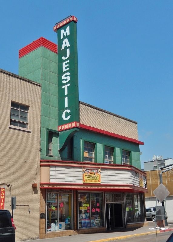
On East Elizabeth Street (Business U.S. 77) south of East Tenth Street, on the right when traveling south.
(English)
Built in 1948, designed by the firm of Pettigrew & Worley, it was part of the interstate movie theater chain founded by Karl St. John Hoblitzelle.
Interstate was an influential vaudeville and later movie theater . . . — — Map (db m119301) HM
On East 6th Street, on the left when traveling west.
This courthouse, the fourth to serve the citizens of Cherokee County, was built in 1940-41 with the assistance of the Federal Works Progress Administration. Designed by the architectural firm of Gill & Bennett, the modern structure is built of . . . — — Map (db m40618) HM
On East 15th Street at J Avenue, on the left when traveling east on East 15th Street.
After a building they shared was destroyed by fire in 1895, the Plano National Bank (est. 1887) and the I.O.O.F. (Odd Fellows) Lodge (est. 1870) erected this commercial building here in 1896. In 1936 the structure was redesigned by . . . — — Map (db m149947) HM
On Richards Street east of 9th Street, on the right when traveling west.
The Texas Legislature created Cottle County in 1876 and named it for George Washington Cottle, who died defending the Alamo forty years earlier. Stage routes connected early ranches, including the OX, SMS, and Matador, to established towns in . . . — — Map (db m104852) HM
On West 8th Street at South Mary Street, on the left when traveling west on West 8th Street.
On Sep. 30, 1947, the Crane Board of Trustees proposed $1,050,000 to build a new high school campus for the growing community. The board and Supt. L.L. Martin hired architect Sylvan Blum Haynes, noted for designing several other schools and . . . — — Map (db m194542) HM
On 11th Street (State Highway 466) east of Avenue E (State Highway 163), on the left when traveling east.
A versatile sculptor of people, animals, birds and religious symbols, McVey attended the University of Texas and taught art there and at Rice University. He played football at Rice under the legendary coach John Heisman in 1924. McVey studied and . . . — — Map (db m7286) HM
On Garland Road, on the right when traveling south.
Early Dallas residents relied on natural springs, Artesian Wells and the Trinity River for their water. By the early 1900s, these sources began to prove inadequate for the growing city. In 1909, under Mayor Stephen J. Hay, the city began acquiring . . . — — Map (db m151483) HM
On South Seaman Street (Texas Route 6) at West Commerce Street, on the right when traveling south on South Seaman Street.
The Texas Legislature created Eastland County in 1858, but sparse settlement delayed organization until 1873, when Merriman (8 mi. NE) became the first county seat. Charles Connellee and Jack Daugherty platted the new town of Eastland near the . . . — — Map (db m105245) HM
Near Park Drive (State Highway 92 Spur) 0.3 miles west of U.S. 77, on the right when traveling west.
In September 1848, the remains of Texans killed in the 1842 Dawson Massacre and the 1843 “Black Bean Death Lottery” were reburied at this site in a sandstone vault. The Kreische family did its best to care for the grave during their . . . — — Map (db m53218) HM
On 25th Street at Strand Rear Street, on the right when traveling south on 25th Street.
The south half of this building was constructed in 1913 to serve as a central passenger station for Galveston's railway system and to house the general offices of the Atchison, Topeka & Santa Fe Railroad's Gulf lines. In 1932 an 11-story tower and . . . — — Map (db m59380) HM
On Smith Street at St. Louis Street (State Highway 146 Spur), on the right when traveling north on Smith Street.
The commission created by the Texas Legislature in 1935 to oversee Texas' centennial joined with the Public Works Administration to build a memorial to Texas Revolution events in Gonzales. The memorial includes a museum, amphitheatre and . . . — — Map (db m128176) HM
On West Kingsmill Avenue at North Russell Street, on the right when traveling west on West Kingsmill Avenue.
Designed by Amarillo architects W.R. Kaufman & Son, this structure was erected in 1931 to house the offices of the Combs-Worley ranching and oil interests and Pampa professions and businesses. Modern art deco architectural influences appear on . . . — — Map (db m55852) HM
On Lamar Street (State Highway 56) at Crockett Street, on the right when traveling east on Lamar Street.
Former Missourian and Civil War veteran Rufus Gaines Hall established a Sherman dry goods store in 1868. The company prospered, in part because it sent 30 notion wagons to sell supplies to settlers on rural farms across 13 counties in North . . . — — Map (db m73390) HM
On South Kilgore Street at East South Street, on the left when traveling south on South Kilgore Street.
Led in the town's economic development following the 1930s oil boom. Prosperity in the midst of the Great Depression influenced the board of directors to build this structure in 1937. Designed by Henderson architect James L. Downing, who used art . . . — — Map (db m138970) HM
On Travis Street, on the right when traveling north.
Prominent real estate developer, publisher, statesman and banker Jesse H. Jones opened the Gulf Building in 1929 with Gulf Oil, National Bank of Commerce, and Sakowitz Brothers as primary tenants. Alfred C. Finn designed the 430-foot high Art . . . — — Map (db m116995) HM
On Louisiana Street at Preston Street, on the right when traveling north on Louisiana Street.
Noted Houston business and civic leader Will C. Hogg (1875-1930) had this commercial structure built in 1921. Early tenants included the Armor Auto Company and the Great Southern Life Insurance Company. The art deco building, designed by the . . . — — Map (db m62353) HM
Near North Main Street south of Girard Street, on the left when traveling north.
This building was constructed to house the activities of Houston's merchants and manufacturers during the post-World War I economic boom. Its location provided access to water, rail, and truck transportation of goods. Completed in 1930, the M & M . . . — — Map (db m119467) HM
Near Holman Street at Caroline Street, on the right when traveling east.
South End Junior High School opened its doors in 1914 with 750 students in an impressive classical revival style structure built here in 1913. South End Junior High became a senior high school in 1923, and in 1926 its name was changed to San Jacinto . . . — — Map (db m119852) HM
The early policies of Mexico toward her Texas colonists had been extremely liberal. Large grants of land were made to them, and no taxes or duties imposed. The relationship between the Anglo-Americans and Mexicans was cordial. But, following a . . . — — Map (db m6702) HM
On South 4th Street (U.S. 287) at East Goliad Avenue ( Highway 7), on the left when traveling south on South 4th Street.
In early 1938, the Houston County commissioners court, with County Judge B. F. Bradley presiding, began making plans for construction of the county's fifth courthouse. Built in 1939 with funds from the Federal Public Works Administration, the . . . — — Map (db m121245) HM
On Lee Street (State Highway 302 Spur) at Stonewall Street (Business State Highway 34), on the right when traveling east on Lee Street.
Built in 1929 as the seventh Hunt County Courthouse, this building was designed by W. R. Ragsdale & Sons of Greenville and Page Brothers of Austin. The 6-story building depicts a transition from classical revival to art deco architecture. It . . . — — Map (db m119688) HM
Near Pearl Street, on the right when traveling west.
The first county building constructed at this site was a jailhouse completed in 1838, two years after the organization of Jefferson County. Located on land acquired from Nancy Tevis, a pioneer settler of the area, it also housed county offices and . . . — — Map (db m118625) HM
On Patton Road at Fort Clark Road, on the right when traveling east on Patton Road.
Constructed in 1932, this building replaced an earlier Fort Clark Post Hall that served as a church, courtroom, theater, and recreational center. A utilitarian military design of clear span construction, brick walls, and a stucco veneer, the . . . — — Map (db m55431) HM
On Texas Avenue at 13th Street, on the right when traveling south on Texas Avenue.
Art deco style office building constructed in 1930 as the new Cotton Exchange Building. Designed by J.B. Davies & Co., Fort Worth, for J.D. Doughty and J.B. Kerby of Weatherford. Now the Carlock Building, it symbolizes the rapid growth of cotton . . . — — Map (db m111493) HM
On North Cedar Avenue, on the right when traveling north.
Charles Lindbergh’s solo flight across the Atlantic Ocean in 1927 dramatically increased worldwide interest in aviation. To participate in this new and potentially significant technology, the City of Lubbock established a municipal airport about . . . — — Map (db m106284) HM
On E. San Saba Street (Farm to Market Road 2092) east of Gay Street, on the right when traveling east.
Menard County organized in 1871, and officials built the first courthouse in 1880 and a second in 1886. In 1930, in a close election, county residents approved a new jail and courthouse. Elmer G. Withers of the Fort Worth firm Withers and . . . — — Map (db m115838) HM
On North Thompson Street, on the right when traveling north.
The Montgomery County Courthouse in the center of downtown Conroe memorializes the remarkable history of one of the oldest counties in the state of Texas. Montgomery County is the third county created by the Republic of Texas, originally part of the . . . — — Map (db m117350) HM
On South Washington Street south of 22nd Avenue, on the right when traveling north.
Architect Guy Carlander designed this administration building for Amarillo College. It was built in 1936-37 and later named for George Ordway, who with James Guleke obtained legislative authority to establish the school. The L-plan building . . . — — Map (db m91566) HM
Organized in August 1887, Potter County erected its first courthouse in 1888 in old town Amarillo. The building was constructed by Mays, Hightower, and Jackson for a cost of $191.
Over the years, three more courthouses were built as Amarillo . . . — — Map (db m91643) HM
On West 24th Avenue east of South Washington Street, on the right when traveling west.
The administration building and the gymnasium were the first two permanent structures built for Amarillo College. Originally known as Badger Gymnasium for the school's athletic teams, this facility was renamed to honor Dr. Natalie Russell, who . . . — — Map (db m91568) HM
Near Main Street at East 5th Street ( Highway 280), on the right when traveling north.
The first Art Deco skyscraper in Fort Worth, the Blackstone Hotel was erected in 1929 for wealthy cattleman C. A. “Gus” O'Keefe, who named it after a visit to the Blackstone Hotel in Chicago. The St. Louis architectural firm of . . . — — Map (db m52781) HM
Near N. 3rd Street at Cypress Street, on the right when traveling west.
This landmark building opened its doors on June 6, 1930, with a celebration attended by more than two thousand guests. Entrepreneur H.O. Wooten envisioned a hotel with accommodations matching those available in New York City, accomplishing the . . . — — Map (db m94650) HM
On West Milton Street at Briar Street, on the right when traveling west on West Milton Street.
Herman Becker (1857-1933) operated a successful downtown café, and he bought part of the historic Bouldin homestead in south Austin in 1891. His son H.E. Becker and son-in-law P.A. Wilde, proprietors of the Becker Lumber Company, donated three . . . — — Map (db m43692) HM
On Congress Avenue at West 6th Street, on the right when traveling south on Congress Avenue.
Alabama native Emerson Monroe Scarbrough (1846-1925) came to Texas following service in the Civil War and settled in Milam County, where he was a successful merchant. He opened a branch of his business, Scarbrough and Hicks, on Congress Avenue in . . . — — Map (db m25731) HM
On East 12th Street (Interstate 40) east of North Main Street ( Highway 83), on the right when traveling west.
The distinctive Tower Building was one of many commercial structures erected in the early 1930s along new U.S. Route 66. Designed by Pampa Architect J.C. Berry, the structure was built by local entrepreneur J.M. Tindall in 1936. The Tower Building . . . — — Map (db m52016) HM
The Kanab Library was built between 1939 and 1940 as a Works Progress Administration (WPA) project. The library is one of 226 buildings constructed in Utah under the WPA and is important in documenting the impact of New Deal programs in the . . . — — Map (db m94940) HM
On West Hillcrest Street, on the right when traveling west.
Dedicated to the history of Bingham High School orginaly built
in Bingham Canyon (1908), about 8 miles west, and later rebuilt
in Copperton... and to all those who proudly call themselves
Bingham sons and daughters.
Built in Copperton, Utah . . . — — Map (db m302994) HM
On East 100 South at South State Street, on the right when traveling west on East 100 South.
The Mountain States Telephone & Telegraph Company finished the first two stories of this building in 1939. The additional four stories were added in 1947 as the demand for telephones boomed after World War II. This building is one of the . . . — — Map (db m146597) HM
On Main Street just north of 4th Street, on the right when traveling south.
In 1919 Park City's newly-organized American Legion proposed to build a meeting
hall in honor of Summit County's World War I veterans. Plans were drawn up, but had
to be tabled when funding could not be found. The project was reactivated in the . . . — — Map (db m277455) HM
On Washington Boulevard, on the right when traveling south.
The Ogden/Weber Municipal Building, 1939, together with the U.S. Forest Service Building and the Ogden High School, are exceptionally significant as the best Art Deco Style building in Ogden and the state of Utah. They also represent important . . . — — Map (db m273318) HM
On Main Street (U.S. 2) at Church Street, on the right when traveling west on Main Street.
Had you stood at this location in the early 1800s, you would have had to lift your skirt off the dirt lane to step up onto the plank sidewalk or guard your hat from the danger of low wooden canopies. Pedestrians competed with horse and carriage on . . . — — Map (db m23579) HM
Near Main Street (U.S. 2) east of St. Paul Street when traveling west.
In 1797, a city planned grid system was laid out for Burlington, incorporating the few transportation routes that existed, including King, Pearl, Church and Battery Streets. At the city’s center, space was reserved for a park (now City Hall Park) . . . — — Map (db m23580) HM
On Portland Street (Old Vermont Route 100) at Bridge Street (Old Route 100), on the right when traveling south on Portland Street.
The Bijou Theatre has operated almost continuously on this site for more than 100 years. The original Bijou, constructed in 1910, was one of the earliest theaters in Vermont to show “talkies”. It was razed in 1937 and this building was . . . — — Map (db m261792) HM
Near Fords Landing Way east of Franklin Street, on the left when traveling south. Reported permanently removed.
One of the last and most architecturally important of the industrial facilities constructed on the waterfront was the Alexandria Branch of the Ford Motor Company. Designed by Albert Kahn (1896-1942) and built on wood pilings over the Potomac River . . . — — Map (db m69852) HM
Near Cameron Street east of North Union Street, on the right when traveling east. Reported permanently removed.
Welcome to Old Town Alexandria! Experience historical charm with contemporary flair from the river to the rails
Plan
Alexandria Visitors Center at Ramsay House
Knowledgeable staff help you create a perfect plan for your . . . — — Map (db m167097) HM
On South Main Street (U.S. 258) at Elm Street, on the right when traveling south on South Main Street.
This property has been
placed on the
National Register
of Historic Places
by the United States
Department of the Interior
circa 1937 — — Map (db m166008) HM
On Ninth Street at Church Street, on the left when traveling south on Ninth Street.
Monument Terrace, completed in 1925, links Church Street with Court Street via 132 steps and 10 landings. The bronze statue, The Listening Post, created by Charles Keck, commemorates Lynchburg’s World War I dead. Several other memorials have . . . — — Map (db m54492) HM
On South Main Street (Business U.S. 460) at Clay Street SW, on the left when traveling west on South Main Street.
The Blacksburg Motor Company building was built by Robert and Mason Heavener, two well-respected Blacksburg businessmen. Robert Heavener was a prominent citizen serving on Town Council and the National Bank of Blacksburg Board of Directors. . . . — — Map (db m84769) HM
Opened in May 1930, the Exchange Building was designed to house more stock and mercantile exchanges than any building in the United States. It was constructed as one of the tallest and largest reinforced concrete structures in the world. . . . — — Map (db m99501) HM
On Coal River Road (West Virginia Route 3), on the right when traveling west.
Completed as Sherman District Jr.
High in 1931. Whitesville School
replaced a building that burned
down in 1929. Wysong and Bengston
designed the rare example of high-style Art Deco architecture in the
southern West Virginia coalfields.
Since . . . — — Map (db m137755) HM
On Scotts Run Road (County Road 19/25) just north of Number Three Hill Road (County Road 19/26), on the right when traveling north.
This building still shows some traces of the original look when it was a vital part of a thriving downtown Osage. You can see the yellow brick, pieces of the cloth awning, and hardware that held the Art Deco sign in the 30s and 40s. Citizens of . . . — — Map (db m177746) HM
On Main Street (State Highway 7) at Price Street, on the right when traveling east on Main Street.
First settled in 1807, Kingwood was named for the grove of trees located where the courthouse now stands. On January 19, 1818, the Commonwealth of Virginia created Preston as its 35th county. Kingwood from its beginning has served as the territorial . . . — — Map (db m34619) HM
On State Street, on the right when traveling west.
The Orpheum Theater is significant as the finest locally surviving theater from the movie palace era. Designed by preeminent theater architects Rapp and Rapp of Chicago, it features a distinctive Art Deco style façade. Its French Renaissance style . . . — — Map (db m50085) HM
On West Wilson Street at Martin Luther King, Jr. Boulevard, on the left when traveling west on West Wilson Street.
Designed by State Architect Arthur Peabody, the Wilson Street Office Building is an extraordinary representation of the Art Deco Style of architecture. Built in three separate stages, 1930, 1938 and 1959, the symmetrically massed structure has a . . . — — Map (db m39919) HM
On Wisconsin Route 77, on the right when traveling east. Reported missing.
1884 … The rush was on to discover “red gold” on the Penokee Range! Speculators, miners and immigrants flocked to this area seeking their fortune in iron ore. Established as a small open pit mine in 1885 by the Oglebay-Norton Mining . . . — — Map (db m45158) HM
On West Wisconsin Avenue, on the right when traveling north.
During the mid 1800s, one of Milwaukee's founding fathers, Byron Kilbourn, lived on the northwest corner of 4th Street and Spring Street (now Wisconsin Avenue). Kilbourn developed the area west of the Milwaukee River, then known as Kilbourntown, and . . . — — Map (db m119881) HM
On South 6th Street at West Norwich Street, on the right when traveling south on South 6th Street.
Organized in 1838, the Town of Lake was one of seven townships that made up pioneer Milwaukee County. Its original borders were Lake Michigan, 27th Street, Greenfield Avenue, and College Avenue. The City of Milwaukee annexed large sections of the . . . — — Map (db m49613) HM
On Washington Avenue at Center Street, on the right when traveling south on Washington Avenue.
It was on this site in the 1840s that Christian Boerner opened a general store, selling primarily dry goods. Little could anyone imagine that this store would ultimately become a movie theater so significant to the life and tradition of the . . . — — Map (db m88548) HM
On Green Bay Road 0.1 miles north of North Main Street, on the right when traveling north.
This two-story art deco style bank building was designed by Albert Moorman and built in 1929 for the second location of the Thiensville State Bank. The building was built on the site of the former Henry J. Thien home. Now known as River Bank . . . — — Map (db m50966) HM
On Washington Avenue (State Highway 32) at 6th Street, on the right when traveling west on Washington Avenue.
The Building
In 1929, the Racine Common Council began the process of creating a new City Hall. The council received two design proposals: one from local architect J. Mandor Matson and another from a Chicago firm. The mayor and aldermen . . . — — Map (db m69164) HM
Side A The Schwartz Ballroom opened to the music of Harold Austin and his New Yorkers on October 20, 1928. As part of the big band craze of the Roaring 20s, dance hall construction boomed while recording and radio broadcasting spread new . . . — — Map (db m150121) HM
On East 8th Street near Warren Avenue, on the right when traveling west.
Front It was at Cheyenne's airport facility that the first de-icing equipment was installed on aircraft. It was also where wide-scale installation of variable-pitch propellers, cabin heaters, and on-board air to ground capable radios was . . . — — Map (db m95463) HM
On Russell Street 0.1 kilometers north of La Trobe Street, on the left when traveling south.
This building was designed by Percy Everett, Chief Architect of the Public Works Department, and built in 1940/43. It housed the Police Headquarters until 1977 and is Melbourne's outstanding example of the Art Deco skyscraper. The adjoining . . . — — Map (db m304322) HM
On Pandora Street at Government Street on Pandora Street.
The cast iron panels on this fence are from the Driard Hotel, built in 1892 and designed by architect John Teaque. It was Victoria’s most prestigious hotel prior to the construction of the Empress Hotel. A reconstructed portion of the original hotel . . . — — Map (db m48477) HM
On Seymour Street just south of Dunsmuir Street, on the left when traveling north.
This unusual building is one of the few surviving Art Deco buildings in downtown Vancouver. Its roofline an exuberant crenelated cornice built in cast concrete and designed in a curvilinear waterfall theme. Downing is best known as the architect of . . . — — Map (db m41926) HM
On Granville Street just south of Robson Street, on the left when traveling north.
This rare example of an art deco exterior employing colourful terra cotta with Egyptian overtones was designed by the architects of Vancouver's city hall as part of a 1929 building renovation. The interior structure dates from a saloon built in 1888 . . . — — Map (db m285298) HM
On Burrard Street at West Hastings Street, on the left when traveling north on Burrard Street.
Marine Building
Architects: McCarter & Nairne
Once the tallest building in the British Empire, the
Marine Building enjoys a special heritage status as
an internationally acclaimed example of Art Deco
architecture. Completed in . . . — — Map (db m284732) HM
On Queen Street at St. Clair Avenue, on the right when traveling east on Queen Street.
This art deco building replaced an earlier post office
at the corner of Zimmerman Avenue and Park Street.
It has had several expansions and remains one of the
most stately bulldings in the heart of Downtown.
The building is designated as a . . . — — Map (db m282280) HM
On Wellington Street (Route 34) just west of Kent Street (Route 83), on the right when traveling west.
English: Created in 1875 by an Act of Parliament, the Supreme Court of Canada is the nation's highest court and one of its most important federal institutions. It is the final general court of appeal, the last judicial resort for . . . — — Map (db m150697) HM
On Spadina Avenue at Dundas Street West, on the right when traveling north on Spadina Avenue.
This building was the first purpose-built Yiddish-language theatre in Canada and a cultural landmark in the local Jewish community.
Architect John MacNee Jeffrey designed the Standard Theatre in the Art Deco style, possibly with architect . . . — — Map (db m288830) HM
On Richmond Street West west of Brant Street, on the left when traveling west.
This historic Art Deco façade was built as part of the Waterworks Building, an important facility within Toronto's water system. When it opened, the complex housed workshops, offices, and storage for equipment and materials.
Designed by James . . . — — Map (db m288817) HM
On William Street 0.1 kilometers north of John Street, on the right when traveling north.
The park and the house in the background were built by one man GTR and CNR Superintendent Walter White.
The house was built in 1923 and the park in 1924. The park was laid out in Art Deco style. It was attached to the railyard by a driveway for the . . . — — Map (db m314035) HM
On Rue Metcalfe just east of Rue du Square Dorchester, on the left when traveling east.
Se faisant face de part et d'autre du boulevard René-Lévesque, les statues de Macdonald et de Laurier sont respectivement le plus ancien et le plus récent des monuments qui ornent le square.
Sir John A. Macdonald
Sir John A. . . . — — Map (db m115820) HM
On Rue Saint-Ambroise at Atwater Avenue, on the right when traveling east on Rue Saint-Ambroise.
Le Marché Atwater
Le marché Atwater, plus grand marché public de Montréal, est inauguré en 1933, pendant la crise économique des années 1930. Allan Bray, conseiller municipal, avait demandé la construction d'un nouveau marché . . . — — Map (db m294735) HM
On 6a Avenida at 8a Calle, on the left when traveling north on 6a Avenida.
Paseo de la Sexta Una vez asentada la ciudad el principal eje vial era la
Calle Real, hoy Paseo de la Sexta, que enlaza la Plaza Mayor de la Constitución con El Calvario templo que marcaba los limites al sur de la ciudad. A lo largo . . . — — Map (db m124075) HM
On 6a Avenida just south of 4a Calle, on the left when traveling south.
Casa Presidencial Tipo: Arquitectura Residencial Construcción: 1933-1943 Estilo: Art-Decó Esta casa fue edificada en los terrenos del antiguo Convento de La Concepción. El arquitecto Carlos Malau la diseñó a solicitud del presidente . . . — — Map (db m115915) HM
On Avenida Juárez just east of Calle López, on the right when traveling east.
Edificio La Nacional. Construidos a inicios del siglo XX para la compañía de seguros “La Nacional”, es representativo del estilo Art Déco en México. English translation “La Nacional” Building Built at the . . . — — Map (db m111304) HM
Museo Diego Rivera Anahuacalli
“Anahuacalli era el templo donde la humanidad se reunía alrededor de los cuatro elementos naturales: agua, fuego, viento y tierra”. Susana Aviña Herrera
El diseño del Anahuacalli - . . . — — Map (db m106873) HM
On Álvaro Obregón at Calle Hidalgo, on the left when traveling west on Álvaro Obregón.
Catedral Basílica de Nuestra Madre Santísima de la Luz.
A diferencia de otras ciudades, la Catedral leonesa no está en la plaza principal. Esto se debe a que el recinto no se concibió originalmente como tal y en ese tiempo, León . . . — — Map (db m127474) HM
On Avenida de los Héroes at Avenida Efraín Aguilar, on the right when traveling north on Avenida de los Héroes.
Hospital Morelos Construcción que inicio en 1936, con el se le
atribuye al Arquitecto Manuel Amabilis Domínguez. Decorado por el escultor Rómulo Rozo, con un reconocido estilo Art-Deco, destacando la "Fuente de la Salud" Relieve que . . . — — Map (db m133971) HM
On Calle 59 at Calle 60, on the right when traveling east on Calle 59.
Edificio La Nacional Desiñado por el destacado arquitecto, Carlos Castillo Montes de Oca en 1936 para albergar oficinas, es un ejemplo de las construcciones que en Mérida mostraron influencia del Art Decó que se manifestó en Yucatán en los años . . . — — Map (db m102307) HM
On Robert-Walser-Gasse at Glockengasse, on the left when traveling north on Robert-Walser-Gasse.
Um 1357 in besitz des glockengiessers Konad Glogger.
1881 fasst architekt Adolf Brunner (1837-1909) die beiden bis ins mittelalter zurückreichenden gebäudekomplexe zu einem fünfgeschossigen haus mit mansarddach zusammen. Die hauptfassade wird in . . . — — Map (db m67120) HM
On Victoria Embankment at Temple Place, on the left when traveling west on Victoria Embankment.
The Yacht London
1927 The Beginning
The Yacht London (“St. Katherine”) was commissioned in 1927 as a survey and inspection vessel by the Port of London Authority from boat builders Philip & Son Ltd of Dartmouth for the princely . . . — — Map (db m118306) HM
On Elliot Street at Cliff Road, on the left when traveling south on Elliot Street.
Welcome to the Plymouth Hoe
History
The Hoe dates back to the medieval era when the first settlers arrived. This was long before the exploits of Sir Francis Drake, who played bowls here while waiting for the Spanish Armada in 1588. The . . . — — Map (db m123773) HM
On Donegall Square North (Northern Ireland Route A1) at Donegall Place, on the right when traveling east on Donegall Square North.
Donegall Square is the heart of modern Belfast, centred on a grassy square occupied by the City Hall and surrounded by buildings in a wide variety of styles and from different periods. The buildings provide a microcosm of the city’s development, . . . — — Map (db m133769) HM
386 entries matched your criteria. Entries 301 through 386 are listed above. ⊲ Previous 100