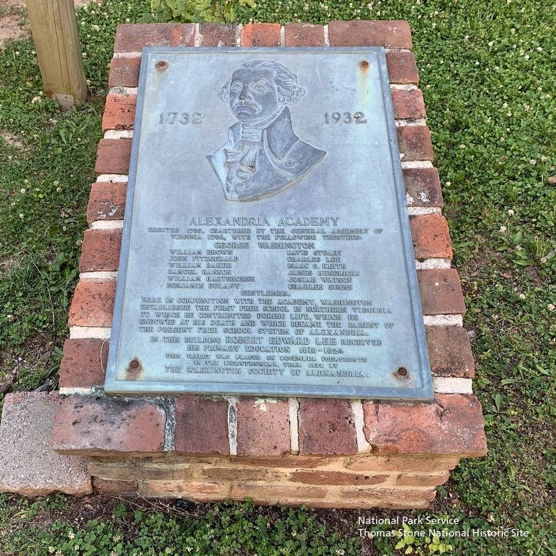
Erected 1785, Chartered by the General Assembly of Virginia 1786, with the following trustees:
George Washington
William Brown
John Fitzgerald
William Baker
Samuel Hanson
William Hartshorne
Benjamin Dulany
David Stuart
Charles . . . — — Map (db m175873) HM
The launch of urban renewal in 1965 led to a boom of archaeological discoveries in Alexandria's Old and Historic District. As buildings were razed exposing artifact-laden layers of history, community outcry demanded that the City address and halt . . . — — Map (db m115770) HM
This structure stands on the site of a late eighteenth-century brick dwelling, part of a complex owned by John Wise and leased to John Gadsby, both noted Alexandria tavern keepers.
The Alexandria Post No. 24, American Legion, purchased the . . . — — Map (db m129180) HM
Three railroads developed in Alexandria during the mid-19th century, a period of limited industrial expansion for the City. Alexandrians had a invested heavily in the Alexandria Canal which opened in 1843, giving the city access to the rich . . . — — Map (db m72379) HM
Chartered A.D. 1788
Destroyed by Fire May 19, A.D. 1871
Rebuilt A.D. 1874
Adolf Cluss - Architect
This plaque mounted in cooperation with the City of Alexandria
by the Alexandria-Washington Lodge No. 22
Ancient Free and . . . — — Map (db m69947) HM
Alexandrians created waterfront land by banking out the shoreline using timber cribbing and old ships including three discovered on this site.
For over two centuries this land embodied Alexandria's working waterfront with an evolving mix of . . . — — Map (db m204474) HM
Alexandria was established by Virginia's colonial assembly in 1749, over four decades the U.S. Congress authorized creation of a national capital on the banks of the Potomac River. Once the final site for the Federal city was selected by President . . . — — Map (db m141166) HM
Wording on stone tablet to left:
Alexandria, Virginia
County seat of Fairfax 1742-1800
Organized 13th July, 1749
Incorporated by the Assembly of Virginia 1779
Ceded to the Federal Government 1789
First boundary . . . — — Map (db m167068) HM WM
In honor and memory of our colleagues in the security profession whose lives were lost in the performance of their duty on September 11th in New York, and all others who have been called upon to make the ultimate sacrifice, ASIS International . . . — — Map (db m131393) WM
Established in 1792, this was the first financial institution authorized by the General Assembly of Virginia. The building was completed in 1807. It is one of the oldest surviving commercial structures in Alexandria and is a fine local example of . . . — — Map (db m81250) HM
The Alexandria Library's Kate Waller Barrett Branch (2 blocks north, 1 block east) and the Alexandria Black History Museum (6 blocks north) have an unusual shared history. The library building was constructed in 1938 and named for Dr. Kate Waller . . . — — Map (db m115715) HM
Between 1911 and 1912, Battery Cove, the shallow bay extending from the southern edge of Keith's Wharf southward to Jones Point, was [unreadable] for the Civil War Battery Rodgers and was used as a small [unreadable] for an extensive dredging . . . — — Map (db m127768) HM
Historical Site Defenses of Washington 1861-1865 Battery Rodgers
Here stood Battery Rodgers, built in 1863 to prevent enemy ships from passing up the Potomac River. The battery had a perimeter of 30 yards and mounted five 200 pounder Parrott . . . — — Map (db m41413) HM
This property
has been listed on the
National Register
of Historic Places
by the United States
Department of the Interior
Bayne-Fowle House
1854
[Additional plaques above:]
The Bayne-Fowle House
has been . . . — — Map (db m134975) HM
Brigadier General Montgomery D. Corse, CSA
Born here in 1816, died Alexandria 1895.
Volunteer, Mexican War 1846-1848.
Prospector in California,
Commander, 17th Virginia Infantry Regiment, CSA.
Post-war civic leader and banker.
Buried . . . — — Map (db m65489) HM
This unique building, constructed of stone and set back from the street, was built by John Carlyle, a British merchant and one of the original founders of Alexandria. Witness to both domestic life and war, today the house stands as a museum . . . — — Map (db m156562) HM
Just two blocks north of this location along Fayette Street (named for the Marquis de Lafayette who visited Alexandria in 1824), near the southwest corner of Queen Street, stood the Old Powder House, dating from 1791-1809. On the same spot, the . . . — — Map (db m115713) HM
Before the American Revolution, the Church of England was the established church of Virginia and part of the colonial government. For administrative purposes, the colony was divided into "parishes" and all residents paid taxes to maintain church . . . — — Map (db m115716) HM
At this intersection, a jail opened in 1827 when Alexandria was a part of Washington, D.C. In the 19th century, it housed criminals, debtors, and Civil War military prisoners. Before Emancipation, the jail was among the locations where enslaved . . . — — Map (db m243181) HM
Civil War Comes to Carlyle House
If you stood in this spot 150 years ago, you would be inside a building! In 1848 James Green purchased Carlyle House and the building in front of you, the first Bank of Alexandria. He turned it into a hotel . . . — — Map (db m129170) HM
In the late 18th and early 19th centuries, this land was part of a larger parcel owned by Colonel Francis Peyton and the land was later inherited by his son, Lucien. In 1851, Lucien Peyton sold this property, depicted on the 1845 map of Alexandria, . . . — — Map (db m115704) HM
This house was built between 1784-1786 by Colonel Michael Swope, a Revolutionary War Battalion Commander, and his wife, Eva Kuhn Swope. Originally from York, PA, Colonel Swope was taken prisoner by the British at the beginning of the war and was . . . — — Map (db m149717) HM
"How sleep the brave who sink to rest
By all their country's wishes blest"
Beneath this mound lie the remains of thirty-four
Confederate Soldiers
Which were disinterred from the Alexandria Soldiers' Cemetery . . . — — Map (db m129286) HM WM
In 1791, surveyors on Jones Point began to lay out the ten-mile square that would become Washington, D.C. The first marker for the survey—the south cornerstone—was set in place on this spot. Although the stone within this protective . . . — — Map (db m60162) HM
Dr. Bernard Stier, O.D. (1930-2005), practiced optometry at this address from the late 1950s to 1998. Dr. Stier moved his practice here after practicing at 716 King Street with his uncle, Dr. Moses Katz, O.D. (1913-1957). A longtime Alexandrian, Dr. . . . — — Map (db m115717) HM
On December 31, 1783, George Washington was feted here by the Gentlemen of Alexandria celebrating his triumphant return from the Revolutionary War. — — Map (db m191971) HM
During the 17th century, settlers began to establish small plantations near landing places on the Potomac River. Oceangoing ships could load tobacco and other goods to export to Great Britain. The area that was to become Alexandria was still . . . — — Map (db m127772) HM
One of King Street's greatest commercial buildings was built by one of Alexandria's most beloved citizens. Edgar Warfield, Jr. was born in 1842, and at the age of 18 he co-founded the "Old Dominion Rifles," a Confederate militia that served in . . . — — Map (db m115749) HM
Alexandria's electric streetcar system, the Washington, Alexandria & Mount Vernon Railway, was established in 1892 between Alexandria and Mount Vernon. In 1896, the line extended into Washington, crossing the Long Bridge where the 14th Street Bridge . . . — — Map (db m115760) HM
On August 18, 1928, former Alexandria police sergeant Elton B. Hummer gave his life in the line of duty. In his honor and as a gift to the city of Alexandria, Mrs. Jelks H. Cabaniss, Jr. commissioned Randal's Masonry Restoration to reconstruct this . . . — — Map (db m225079) HM
As Planning Director (1977-1984) Engin Artemel led the City of Alexandria in planning for the transformation of its industrial waterfront to one that can be enjoyed by visitors and residents alike. Inspired by beautiful active urban waterfronts in . . . — — Map (db m99596) HM
Panel 1 - upper middle of east face:
The First Presbyterian Church of Alexandria founded A.D. 1772 House of worship erected 1774. Destroyed by lightning July 20, 1835. Rebuilt on the same lot A.D. 1836.
Panel 2 - . . . — — Map (db m122164) HM
As Virginia's population grew, so did its reliance on fish from the Potomac River as a dietary staple. In 1813, the city authorities passed a law designating the county wharf at the foot of Oronoco Street as the official place for landing fish. . . . — — Map (db m239715) HM
The Alexandria waterfront has changed dramatically since the City's founding in 1749. The Potomac River once flowed along the high banks about two blocks west of here near Water (now Lee) Street. Two hundred and fifty years ago, the area where . . . — — Map (db m182672) HM
Erected to the Memory of the Soldiers, Sailors and Marines from Alexandria, Virginia who gave their lives during the World War.
Geo. M. Anderton •
Herbert Bernhard •
Thos. W. Cook •
John Crilly •
Arthur Curran •
Percy C. Dove • . . . — — Map (db m129194) WM
University of Virginia, LLB
1936
Admitted to practice before the Virginia Supreme Court of Appeals
1936
United States Naval Reserve Officer, World War II
1942-1946
Mayor and Member of City Council of City of Alexandria . . . — — Map (db m115750) HM
The building at 1315 Duke Street, two blocks south of here, was originally built around 1812 as a residence for General Robert Young, commander of Alexandria's militia, who died in 1824. This three-story brick building then became the . . . — — Map (db m115706) HM
Organized 1774
Original building erected July 23, 1855
New addition erected October 30, 1972
Housing relics for future generations.
Gift of
Bernard B. Brown — — Map (db m65818) HM
In an 18th century town of mostly wooden buildings, where open flames provided heat, light and cooking on a daily basis, Alexandrians constantly faced the danger of fire. Water to fight fires had to be carried in buckets from nearby wells, town . . . — — Map (db m115714) HM
Erected 1792. Popular resort and famous hostelry of the Eighteenth Century. Here was held in 1798 the first celebration of Washington's Birthday in which he participated, and from its steps Washington held his last military review and gave his last . . . — — Map (db m146) HM
Restoration
In the early 20th century Alexandria's economy was struggling, despite major efforts to develop a strong industrial base. But by the early 1920s, inspired by efforts to restore the colonial city of Williamsburg, Virginia, . . . — — Map (db m129178) HM
Gadsby's Tavern Museum consists of two buildings — the smaller c.1875 tavern and larger 1792 City Tavern and Hotel. While both were constructed by John Wise, they were made famous by John Gadsby, a rising tavern keeper who rented the buildings . . . — — Map (db m115755) HM
This building dates to 1801. Between 1852-1911 the Alexandria Gazette newspaper was printed here. In 1862 while Alexandria was occupied by the North during the Civil War, Union soldiers burned this building because it was reported here that St. Paul . . . — — Map (db m41832) HM
Published in 1894, The Life and George Henry Together with a Brief History of the Colored People in America captures the personal experiences of the author in his own words. George Henry described himself as the enslaved captain of the . . . — — Map (db m239721) HM
Trustee of Alexandria 1752 until death in 1765, and was succeeded on board of trustees by George Washington. Member of House of Burgesses and moved the adoption of Patrick Henry's resolution on the "Stamp Act." — — Map (db m131392) HM
George Washington considered Alexandria his hometown after its founding in 1749, and it is here that he came to do business, learn the events of the world, pick up mail, and visit friends. His first association with the town was probably as a 17 . . . — — Map (db m115747) HM
A visit to George Washington's Mount Vernon estate, about nine miles to the south, has long been viewed as a patriotic duty of Americans. In the late 19th century, visitors often traveled there from Washington by boat, stopping first in Alexandria. . . . — — Map (db m115719) HM
The area around Jones Point, which lies just south of the nation’s capital, was an obvious location for early defensive fortifications. During the Civil War (1861-1865), Battery Rodgers was built overlooking the cove to guard the river approach . . . — — Map (db m69911) HM
When Alexandria was founded in 1749, this corner was planned as the main intersection in the new town, with the streets named in honor of Thomas Fairfax, 6th Lord Fairfax of Cameron, a major land-owner in Northern Virginia. From Cameron Street, . . . — — Map (db m167213) HM
In 1804, Francois-Dominique Toussaint L'Ouverture, a formerly enslaved Haitian Black military leader, led the only successful uprising of enslaved people in the Western Hemisphere. As a result of the rebellion, the Caribbean island of Haiti . . . — — Map (db m239747) HM
Alexandria was named for the family of John Alexander, a Virginia planter who in 1669 acquired the tract on which the town began. By 1732, the site was known as Hunting Creek Warehouse and in 1749 became Alexandria, thereafter a major 18th-century . . . — — Map (db m47) HM
In the 1790's many Alexandria streets were paved with cobblestones. According to legend, Hessian soldiers provided the labor to cobble Princess Street. These cobbles remained essentially untouched until 1979, when the street was restored using the . . . — — Map (db m197474) HM
[Top plaque]
Home of Charles Lee
First Collector of Customs, Alexandria
1789 - 1793
Designated an
Historic Customhouse
Vernon D. Acree
U.S. Commissioner of Customs
1976
[Bottom . . . — — Map (db m129176) HM
Close personal friend and family physician of Washington. Surgeon in Braddock's campaign, also with Washington throughout the Revolutionary War. Was at his bedside when he died and received his last messages. — — Map (db m167158) HM
Was consulting physician in Washington's last illness. At the moment of Washington's death he stopped the bedroom clock, which can be seen in Alexandria Washington Lodge, and conducted the Masonic Funeral service at his grave. — — Map (db m71751) HM
Home of
George Gilpin 1740-1813
Member, Fairfax Committee of Safety
Colonel, Virginia Regiment Fairfax Militia,
Served with General George Washington
in New Jersey campaign and Battle of Germantown
Surveyor of the Town of . . . — — Map (db m115764) HM
Famous Revolutionary Soldier, Father of Robert E. Lee. Was ardent supporter of Federalists. Defended Washington in political contests and delivered eulogy before Congress at Washington's Death in which he used the now famous phrase:
"First in . . . — — Map (db m72316) HM
All stories should end with accumulating snow.
Increasing depth racing the concluding plot
Erasing the physical details of the recent narrative
Leaving only softened shapes and relative positions
And as the end obliterating even . . . — — Map (db m143372) HM
Fellow townsmen, brother Masons, trusted friends, comrades in the cause of American Independence.
Col. Charles Simms
Col. Dennis Ramsay
Col. William Payne
Col. George Gilpin
Col. Philip Marsteller
Col. Charles Little
In memory . . . — — Map (db m129193) HM
During the 19th century, numerous entrepreneurs gradually improved the lots and expanded the warehouses and wharves associated with the 200 block of the Strand. Josiah Davis owned many properties along Alexandria's waterfront and bought property . . . — — Map (db m195640) HM
Farm house in Fairfax County, Virginia, located upon part of a seven hundred acre land patent granted to Margaret Brent in 1654. Owned and occupied by descendants of John Douglass Brown and Mary Goulding Gretter since 1816. — — Map (db m71738) HM
This building was the warehouse of John Fitzgerald, Alexandria merchant and officer of the third Virginia Regiment of the Continental Line.
Colonel Fitzgerald was a close friend of General George Washington and he was his secretary and aide-de-camp . . . — — Map (db m81247) HM
American Indians first frequented Jones Point to hunt and fish. The point is likely named for an early English settler. By the 1790's, military installations were established at Jones point due to its strategic location on the Potomac River. The . . . — — Map (db m79997) HM
■ a living public art sculpture encompassing the entire park ■ a combination of three garden types: a hanging garden, topiary garden and rain garden ■ the result of an international design competition an important example of . . . — — Map (db m243158) HM
Robert E. Lee left this home that he loves so well to enter West Point. After Appomattox he returned and climbed the wall to see “if the snowballs were in bloom.” George Washington dined here when it was the home of William Fitzhugh, Lee’s kinsman . . . — — Map (db m8548) HM
Revolutionary War hero Henry "Light Horse Harry" Lee, father of Confederate General Robert E. Lee, purchased several lots on North Washington Street in Alexandria soon after the War for Independence. He lived with his family in a house on Cameron . . . — — Map (db m115721) HM
Discover the spirit of Alexandria that has been making history for well over two centuries
Founded in 1749, Alexandria was the center of commercial and political activity for early patriots such as George Washington as the seeds of the . . . — — Map (db m115776) HM
Alexandria's Market Square was established only a few years after the town was founded in 1749. The site selected was centrally located in a prime block of the colonial settlement, immediately adjacent to the City Hall. At the time, Cameron and . . . — — Map (db m115757) HM
In the early morning hours of May 24, 1861, the day after a public referendum in Virginia supported secession from the United States, Alexandria was invaded by Union forces crossing the Potomac. Colonel Elmer E. Ellsworth, the young commander of the . . . — — Map (db m115753) HM
On September 6, 1654, this site was included in a patent of 700 acres granted by the Colony of Virginia to Mistress Margaret Brent (c1601–c1671). An extraordinary woman, she spent most of her adult life fighting discrimination of her sex, she was . . . — — Map (db m62020) HM
Theodore Roosevelt Island
This wooded island is a tribute to the vision of our 26th president. Explore, on foot, 2.5 miles of trails and the memorial plaza.
Lady Bird Johnson Park
Take time to visit the Lyndon Baines Johnson . . . — — Map (db m233790) HM
The concrete foundations you see here were part of a craneway servicing two shipways and launch sites -- elements of an enormous World War I-era shipyard. To speed delivery of cargo ships needed for the war effort, the Virginia Shipbuilding . . . — — Map (db m62323) HM
"Ready All…Row!"
Beginning in 1880
ODBC was founded in 1880 as a rowing, recreational, and athletic club in Alexandria.
The Club won its first rowing regatta in 1887 and continues to support rowing to this day.
The . . . — — Map (db m195593) HM
The Old Dominion Boat Club's objective is to promote charitable and community service, athletic and water-related activities, and fellowship among its members.
Alexandria's Sportsman's Club
1947 - Present
Founded on an idea by . . . — — Map (db m195633) HM
Living history
Discover the spirit of Alexandria that has been making history for centuries.
Alexandria has had a role in our nation's history since its founding in 1749. George Washington called Alexandria home in his . . . — — Map (db m236052) HM
Orange & Alexandria Railroad roundhouse, formerly located near Duke and South Henry Streets. Engine named after Brigadier General Herman Haupt, Chief of Transportation, U.S. Military Railroads during the Civil War. Mathew Brady photograph after . . . — — Map (db m72622) HM
Lieut. Col U.S.A., Revolutionary War
1st Battalion, Lancaster County
Pennsylvania Associators, 1777
Assistant Deputy Quartermaster General
Member of
The Pennsylvania Constitutional Convention, July, 1776
Original stone removed . . . — — Map (db m195645) HM WM
[Marker is a series of photos:]
Washington, Alexandria and Mt. Vernon electric railway train at King and Pitt Streets, circa 1915.
Courtesy of Alexandria Library, Special Collections
North side of the 300 . . . — — Map (db m156844) HM
Pioneer Mill once stood at the end of Duke Street. The photograph shows the many wharves that occupied the blocks where buildings and parks now stand. Warehouses lined the Waterfront interspersed with processing plants for flour and . . . — — Map (db m182674) HM
On August 29, 1814, Alexandria surrendered to the British forces. These terms of surrender protected American homes but gave the enemy flour, cotton, tobacco, and other goods as well as military supplies and weapons. On September 3, the . . . — — Map (db m143268) HM
Historically, Alexandria's development moved from east to west, and three distinct areas of the city have unofficially been known as the "West End." The first West End ended at Shuter's Hill, the current site of the George Washington Masonic . . . — — Map (db m115709) HM
Originally constructed in 1883 as
The Columbia Firehouse
Restored as a restaurant under the
direction of James J. Matthews, Jr.
for Marilyn and Harry Lewis.
Completed November 1981
— — Map (db m156845) HM
George Washington lived in and traveled from this region, pursuing his dream of westward expansion—to connect the Atlantic Seaboard with the frontier West. His efforts to use the Potomac River as a commercial artery influenced industrialization . . . — — Map (db m127767) HM
This Federal-style townhouse and its adjoining twin were built ca. 1793. Original owner John Potts, Jr., secretary of the Potomac Company, deeded the house in 1799 to William Fitzhugh of Chatham, member of Virginia's Revolutionary Conventions and . . . — — Map (db m188751) HM
Jones Point was once a wooded wilderness, ringed by marshes and periodically cut off from the mainland during high tide. American Indians made use of both woodland and wetland for food, tools and supplies. By the 17th century, Europeans had . . . — — Map (db m62028) HM
In the early 1800s Alexandria was part of the District of Columbia and an important port with its own militia. In summer 1814, though, Alexandria’s militia had been sent to defend Maryland from the British invasion. So on August 28, four days . . . — — Map (db m81226) HM
Physician General and Director of Hospitals, Middle Department, Continental Army, Charter member, Society of the Cincinnati. Author of the first American Pharmacopoea. President of Board of Trustees of Alexandria Academy, at General Washington's . . . — — Map (db m71757) HM
After Virginia seceded in the spring of 1861, Unionists met in Wheeling and organized a state government loyal to the U.S. under Gov. Francis H. Pierpont. The Restored Government, which sent representatives to the U.S. Congress and raised federal . . . — — Map (db m191972) HM
The 500 block of King Street has long been associated with retail trade in Alexandria. In the late 18th century, Adam Lynn, Sr. owned the quarter-block at this corner of King and St. Asaph Streets, where he operated a small bake shop selling . . . — — Map (db m115746) HM
Alexandria, D.C.
In 1791, Alexandrians applauded their inclusion in the District of Columbia, believing that the town would benefit economically as part of the Federal district. These positive feelings toward inclusion in the District . . . — — Map (db m239716) HM
Potomac River ferry companies date back to as early as 1740, when Hugo West received permission to operate a ferry from the Hunting Creek warehouse in Prince William over the Potomac River to Fraziers Point in Maryland "...the price for a man 1 . . . — — Map (db m143267) HM
Founded 1795
by
Very Rev. Francis Jonatus Neale, S.J.
of Georgetown College
and
Colonel John Fitzgerald, Aide de Camp to General George Washington and one time Mayor of Alexandria
Prior to 1785, the Catholic community of Alexandria . . . — — Map (db m72355) HM
13056 entries matched your criteria. Entries 301 through 400 are listed above. ⊲ Previous 100 — Next 100 ⊳