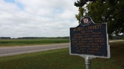
Alabama's first historian lived on plantation nearby. From traders and Indians he gathered materials for his authentic history of early Alabama and the Southeast. — — Map (db m304048) HM
Born August 13, 1810 in Anson County, North Carolina. Albert
James Pickett was the youngest child of Colonel William Raiford
Pickett and Frances Dickson. The family moved to the Alabama
Territory in 1818, establishing a plantation and lucrative . . . — — Map (db m304050) HM
Robert Ripley's world-wide syndicated Believe It Or Not! column for July 31, 1935 read: "C. D. Abbott is the first citizen of the U.S.A. He is first alphabetically in Autaugaville, the first town in Autauga, the first county in Alabama, the . . . — — Map (db m68839) HM
Dating to the Reconstruction Era, Greater Mallard's Chapel
A.M.E. Church Cemetery has 151 marked graves and many
unmarked graves. Associated with Greater Mallard's Chapel
A.M.E. Church, which purchased the church building and
property in 1885 . . . — — Map (db m294227) HM
The Taylor Family Cemetery and surrounding brick wall date to the mid-1820s. The wall contains bricks hand-made in Autauga County with Alabama red clay. The family of Benjamin Taylor, Sr., (1761-1836) started the cemetery. Benjamin married . . . — — Map (db m306057) HM
Old Harmony Cemetery is the final resting place of some of Western Autauga County's earliest settlers. The cemetery includes burials of members of both Harmony Baptist Church and Caver's Methodist Protestant Church. Harmony Baptist Church was . . . — — Map (db m267938) HM
Established prior to 1833, the Robinson-DeJarnette Cemetery is located
on property first granted by the U. S. Government to early Autauga County
settler James Jackson. In 1825, Jackson transferred the land patent to
Eli Terry Sr. On March 16, . . . — — Map (db m294231) HM
The William Dixon Smith family settled in Autauga County in 1818, prior to Alabama Statehood. The family patriarch, William Dixon Smith (1809-1902), was a planter, forester, and operated a sawmill and gin. He also operated a mercantile business . . . — — Map (db m304169) HM
The James Jackson Cemetery is the final resting place of James Jackson,
one of the earliest White settlers in old Autauga County. He settled in the
area in 1817, when Alabama was still a territory. He established a large
plantation, Auburn Hill, . . . — — Map (db m303972) HM
By 1900, America's forests were in a depleted
state. In the 1920's and 30's, conservationist
and lumberman Evan Frank Allison led the
movement to revitalize Alabama's forests and
wildlife. At one time he and his forester
counted less than five . . . — — Map (db m207007) HM
When the Soldiers' Home opened, veterans
cooked for themselves in their cottages. Later,
cooks were hired, serving meals in one
cottage of each row. Around 1920, the Mess
Hall was constructed, providing the most
efficient method of serving . . . — — Map (db m206693) HM
Located on the site of the Old Myrick Plantation, George Myrick established this cemetery. He arrived in Autauga County in 1826 and he built his home just north of this site. The original chapel dates to the 1870s and served as a local school as . . . — — Map (db m206686) HM
The individual cottages at the Alabama
Confederate Soldiers' Home contrasted
with the large barracks found at many
other Civil War veterans homes across
the country during the early 1900's.
All nine cottages of the Soldiers' Home
had . . . — — Map (db m206689) HM
The individual cottages at the Alabama
Confederate Soldiers' Home contrasted
with the large barracks found at many
other Civil War veterans homes across
the country during the early 1900's. The
cottages in this row were paid for by
private . . . — — Map (db m206798) HM
Erected on this site in 1904 by the
State of Alabama, the Hospital was
constructed to meet what was
described as the "pressing need" for
medical care of the veterans at the
Confederate Soldiers' Home. This
25-bed facility was said to . . . — — Map (db m206691) HM
Milton was settled around 1829. By 1840 it had become a prominent village of Autauga County. It was known as "Milton City” when the 1886 flood buried it in sand. Among the early families were Wm. L. and Sarah Taylor. Elihu and Elizabeth Parr Bates. . . . — — Map (db m209092) HM
Constructed in 1854, Ivy Creek Methodist Church originally was part of the Mulberry Beat in Autagua County. The church served the communities of Hamilton, Huckabee (Evergreen), Milton, Statesville-Mulberry, and West Autaugaville. Ivy Creek Methodist . . . — — Map (db m158666) HM
Created in 1818 by an act of Alabama Territorial Legislature. Autauga Indians lived on creek from which the county takes its name. Autaugas were members of the Alibamo tribe. They sent many warriors to resist Andrew Jackson's invasion in Creek War. . . . — — Map (db m27907) HM
Alabama takes its name from this tribe,
whose settlements were located along the
headwaters of the Alabama River. Early French
colonists called them Alibamons, and engaged
the tribe in trade at nearby Fort Toulouse.
When the French . . . — — Map (db m294212) HM
Side 1
Water has always played a significant role in the history of Prattville. Daniel Pratt chose the location for his new town because of the proximity to Autauga Creek and the Alabama River. This area was referred to as an . . . — — Map (db m70815) HM
This antebellum plantation house was completed by Capt. William Montgomery, a contemporary of Prattville's founder, Daniel Pratt.
This “Deep South” architecture reflects the Federal style with the later addition of a Colonial Revival facade . . . — — Map (db m294722) HM
Side 1
Daniel Pratt
Founder of Prattville
Daniel Pratt, a native of New Hampshire, became an industrialist, statesman and philanthropist in Alabama. He was a Methodist in both heart and practice. He encourage the development of the . . . — — Map (db m70813) HM
Daniel Pratt CemeteryFinal resting place of early Alabama industrialist Daniel Pratt, 1799-1873, and wife Esther Ticknor Pratt, 1803-1875. He was from New Hampshire and she, Connecticut. Married 1827 at Fortville, Jones County, Georgia. . . . — — Map (db m168941) HM
Prattville is often referred to as “The Fountain City” for the numerous free-flowing artesian wells found here. A 1933 edition of the Prattville Progress noted that there were more than 400 of these artesian wells in Prattville . . . — — Map (db m70805) HM
First Missionary Baptist Church was originally constructed across Autauga
Creek in the 1850s as a white Presbyterian church. That congregation
gifted the building to the Black congregation several decades later.
For over a century, the First . . . — — Map (db m303955) HM
Side 1
First Presbyterian Church of Prattville, Alabama
Organized 1846 by Pastor Wm. H. Mitchell, this congregation succeeded Millenium Hope Presbyterian, 2 mi. E. of town. Pastor Jas. K. Hazen (1861-77) married Mary Ticknor, . . . — — Map (db m81479) HM
Known as Fair Road, Sixth Street from Northington Street to the big curve was called “Happy Hollow”. The road went to the Fair home place but also curved right, into Warren Circle. Here stood a small frame church where the congregation’s . . . — — Map (db m70800) HM
Located within Daniel Pratt Historic District, this park overlooks Autauga Creek and the manufacturing complex around which this New England style village developed. Daniel Pratt founded Prattville in 1839, and patterned the town after those of his . . . — — Map (db m27958) HM
Indian Springs Post Office
Location of considerable Community activity in the early nineteenth-century Autauga County
Thomas Hill House
Site of first Court after Autauga became a County
Union Baptist Meeting House
1830s . . . — — Map (db m70798) HM
In 1919, Anthony Townsend donated 5 acres of land for this school. In 1913, Julius Rosenwald, CEO of Sears & Roebuck, and Booker T. Washington established the Rosenwald School program to improve the quality of public education for African American . . . — — Map (db m158654) HM
Built circa, 1840s by A.K. McWilliams, this story and one-half Federal-style raised cottage with Greek Revival elements was the residence of Amos Smith, who named the town of Prattville.
The west front parlor was the meeting place where the . . . — — Map (db m27982) HM
In 1957, the Citizens Community Improvement Club, represented by Willie Lee
Wood Sr., Mary E. Averhart, Lewis Douglas, and Isom Jones, successfully
lobbied the City of Prattville to designate a vacant 1.5-acre lot as a new
park for African . . . — — Map (db m294217) HM
The county's third courthouse was used until 1906. George Littlefield Smith, an early citizen of Prattville, designed and built the Italianate-style structure. Earlier county seats were Washington, then Kingston.
Marker placed by the . . . — — Map (db m70808) HM
This cemetery is one of the oldest cemeteries in Autauga County having been established as a burial ground by at least 1841. The land was officially set aside as a burial ground when the county seat was in this area from 1834 to 1868. The area . . . — — Map (db m82561) HM
The plank road was constructed of large pine logs, sawed lengthwise and laid round-side down. Daniel Pratt built the road for public benefit and to provide transportation from the Pratt Cotton Gin Factory to Washington on the Alabama River. Over . . . — — Map (db m27983) HM
Once the world's largest plant manufacturing cotton gins.
Founded 1833 by Daniel Pratt, the greatest industrialist of Alabama prior to 1860. Pratt's many industries were of great aid to Confederacy during Northern blockade. — — Map (db m70799) HM
Daniel Pratt, Prattville’s founding father, constructed an imposing home and garden within a quarter-mile of this site on Autauga Creek, near his industrial complex. The large home was designed and erected by Pratt himself, a noted architect / . . . — — Map (db m27985) HM
On this memorial are engraved the names of the 100 original officers and men of the Prattville Dragoons. Their dedication to their families, their homes and their county is remembered and honored by their descendants.
Officers
Jessie . . . — — Map (db m129581) WM
Rocky Mount Cemetery was established on this sacred ground for families who settled Cobb’s Ford and the surrounding area. The oldest marked burials date to the 1890s. Numerous veterans of the Civil War and World Wars I and II are buried here. Rocky . . . — — Map (db m158661) HM
Saint Mark's was organized in 1859 as a mission of the Diocese of Alabama. Services were first held at the Presbyterian Church and in the old Court House. In December 1876, the congregation purchased an old wooden frame chapel from the Methodists . . . — — Map (db m70801) HM
Sallie Mae Hadnott was a leading civil rights activist in Autauga
County During the 1960s and 1970s, at great personal risk,
Hadnott helped found and lead several organizations dedicated
to improving the lives of African American citizens and . . . — — Map (db m294216) HM
Beloved teacher of Prattville Academy
1867 • on this site • 1868
whose memory will be forever
cherished by people of Prattville, Ala.
whom he loved and served — — Map (db m70820) HM
Side 1
Sidney Lanier
1842-1881
The poet and musician, born in Macon, Georgia, was Academy principal in 1867-68. He married Mary H. Day of Macon in December 1867. In Prattville, they lived at the Mims Hotel and later in Dr. S.P. . . . — — Map (db m70802) HM
This boulder erected by
The Merrill E. Pratt Chapter U.D.C.
April 26, 1916,
marks the spot where
The Prattville Dragoons
assembled in April, 1861,
on the eve of their departure
to the war,
and is commemorative of their . . . — — Map (db m70819) HM WM
A native of Prattville, Wilson Pickett was raised singing gospel in local churches. Upon moving to Detroit as a teenager, he began to blend gospel-style with rhythm and blues, resulting in some of "the deepest, funkiest soul music" to come from the . . . — — Map (db m70804) HM
The Vine Hill Cemetery was established in the 1880s. The cemetery sits atop
a ridge in western Autauga County and has over 100 marked graves. The
oldest is for Kate Elizabeth Sherrill, who died in 1890. The cemetery
is the final resting place . . . — — Map (db m304120) HM
In 1870, Marbury Lumber Company donated land for the White Pond Methodist Church and Cemetery. It is believed that the first burial in the cemetery, marked only by a pile of bricks, took place that same year. The earliest marked grave is of Thomas . . . — — Map (db m158662) HM
First governor of Alabama
1819-1820
Only governor of Alabama Territory
1817-1819
Born in Amelia County, Va., Oct. 2, 1781
In U.S. Congress from Georgia 1805-1813
Moved here from Elbert County, Ga., 1817
Buried in private . . . — — Map (db m71180) HM
Memorial dedicated to
the memory of
David Franklin Foreman
Harriet Bell Wilson Foreman
They deeded this land to the
Coosa River Community to build
two churches and a school house.
Date deeded Sept. 15, 1903
Marker erected by their . . . — — Map (db m225568) HM
At this site stands the cabin where country music legend Hank Williams composed the song “Kaw-liga” in August, 1952. The song’s title was derived from the name of a Creek Indian town located on the banks of the Kowaliga Creek until 1836.
. . . — — Map (db m68038) HM
In 1820, Elisha Milton Cain founded Cain's Chapel, one of the oldest continuous church congregations in the River Region. Cain moved from Orange County, South Carolina to the Pine Flat area in 1817. In 1820, he moved to this area and constructed . . . — — Map (db m263960) HM
In the late 1930's and early 1940's Holtville School won national acclaim as one the foremost examples of the progressive education movement in the U.S. It was one of 33 southern schools in 1938 chosen to receive financial support in developing new . . . — — Map (db m83689) HM
Robinson Springs Camp
1861-1865
Confederates
These lent our cause it's Holy Consecration
left front:
Volunteers from Robinson Springs Community,
Abercrombie, Leonard ∙ Allen, James M. Co. D. 21 Ala. Regt. ∙ . . . — — Map (db m83692) WM
Side 1:
Clear, bubbling springs have enticed people to this vicinity for thousands of years. Native American hunting paths led to them and after the defeat of the Creek Indians by the United States in 1813, old trails became the Jackson and . . . — — Map (db m71177) HM
This notable Greek Revival structure was completed in the late 1840's on land donated by Eli Robinson. The congregation was established 1828-1830 and the first church, built of logs, was located c. 1 mile east of here. Charter members were: Rev. . . . — — Map (db m71178) HM
A Recreation Center
for
Millbrook, Robinson Springs, and Coosada
Memorial Center
Dedicated as a living memorial to the boys
who lost their lives in the service of their
country during World War II
1941 — 1945
Frank . . . — — Map (db m83721) WM
The Alexander McKeithen family for which it is named, played a significant role in the history of Old Autauga County. Alexander's father, Archibald McKeithen settled in an area that became part of the village that became Robinson Springs. A . . . — — Map (db m292773) HM
Brigadier General Birkett Davenport Fry, CSA
(1822-1891)
In his lifetime General Birkett D. Fry was a cadet at Virginia Military Institute and West Point; 1st Lt. (U.S. Infantry) in Mexican War; lawyer in California; mercenary-soldier of . . . — — Map (db m95112) HM
"Get there first with the most men"
"Never stand and take a charge...
charge them too"
"Keep the skeer in 'em"
Dedicated to those brave Confederate Militia, Home Guard and University of Alabama Cadets who Repelled Union Raiders ahead . . . — — Map (db m254023) HM WM
"Do your duty in all things. You cannot do more; you should never do less"
"Duty, then is the sublimest word in our language"
"There is true glory and true honor: the glory of duty done-the honor of the integrity of principle" . . . — — Map (db m254112) WM
This monument is dedicated to the memory of all SCV Camp 1921 members who haved [sic] joined General Stonewall Jackson across the river to rest beneath the shade of trees
Funding provided by the Alabama Division of the . . . — — Map (db m254097) WM
"Nothing fills me with deeper sadness than to see a Southern man apologizing for the defense we made of our inheritance. Our Cause was so just, so sacred, that had I known all that has come to pass, had I known what was to be inflicted upon me, . . . — — Map (db m254019) HM WM
Nathan Bedford Forrest was born in Bedford County Tennessee, July 13, 1821. He was the eldest of nine children born to William and Mariam Beck Forrest. At the age of sixteen, Forrest took on the responsibilities of providing for the family after . . . — — Map (db m253891) HM
General Robert E. Lee (1807-1870) has continuously ranked as the leading iconic figure of the Confederacy. A son of Revolutionary War hero Henry "Light Horse Harry" Lee, Robert graduated from the United States Military Academy at West Point in . . . — — Map (db m253909) HM
Only Confederate armory not destroyed during the Civil War.
Col. Gorgas, ordnance chief, had carbine shop moved here
into Tallassee Mfg. Co. mill in spring, 1864 as war threatened Richmond, Va. armory.
War ended before plant . . . — — Map (db m83722) HM
The history of this church encompasses the span of worldwide Methodism from the time of John Wesley to the present. A Methodist Society was organized in Tallassee in 1853 by 15 charter members who gathered in the "White Store," a mill company . . . — — Map (db m160158) HM
Located twenty-seven miles northeast of Montgomery on the banks of the Tallapoosa River, Talisi, (Tallassee) was a major Creek Indian village prior to forced removal to Oklahoma in 1836, In January of 1844, two entrepreneurs named Thomas M. . . . — — Map (db m253898) HM
Thomas Jonathan Jackson was born in what is now Clarksburg, West Virginia. Jackson and his sister were raised by their mother. She died when he was seven. They were the raised by an uncle, until Jackson left for West Point. He worked his way up . . . — — Map (db m253905) HM
Tukabatchee
On this bend of the Tallapoosa River, stretching out before you, lay one of the ancient towns of the Muscogee Creek People, called Tukabatchee. Tukabatchee is one of the original four mother towns of the Creek . . . — — Map (db m92945) HM
William Bartram, America’s first native born artist-naturalist, passed through Elmore County during the Revolutionary era, making the first scientific notations of its flora, fauna and inhabitants. In 1776 the appointed botanist of Britain’s King . . . — — Map (db m69431) HM
The memorial includes inscriptions on four sides.
Richard Gunter Crommelin
Lieutenant Commander U.S. Navy
January 8, 1917 - July 14, 1945
Young fighter pilot on U.S.S. Yorktown CV-5. Shot
down two Japanese Zeros in Battle of Coral . . . — — Map (db m137263) HM WM
In memory of those who served
and those who made
the supreme sacrifice
in that forgotten war
from Elmore County
Booth Izea PVT AR 11/28/50 Died Capture
Brozell Albert M CPL AR 09/09/50 Killed in Action
Causey Billy J PVT AR 08/17/50 . . . — — Map (db m67935) WM
Constructed in 1924 on five acres, this building was one of nine schools constructed in Elmore County with funding assistance from the Julius Rosenwald Fund. Between 1912-32, Julius Rosenwald, a Jewish philanthropist and CEO of Sears, Roebuck and . . . — — Map (db m70548) HM
In honor of the fallen heroes of Elmore County who gave their lives in the Vietnam War
Clark, Richard • Johnson, Joseph W. • Ruffin, James Thomas
Cook, Larry Davidson • Mathis, David Linwood • Smith, John Lee
Cottrell, Willie James • . . . — — Map (db m67932) WM
Dedicated on this Centennial to those Who
Served and Made the Ultimate Sacrifice
Barker, Adolphus · Lewis, Henry
Benton, Edwin J. * · Macon, Preston A. *
Boswell, James A. ** · Martin, Oders M. *
Boyer, James T. · Melton, William H. + . . . — — Map (db m145086) WM
Baptists settlers scattered along the Coosa River Valley established the church May 26, 1821. For the first twenty years, it was mostly known as the Coosa River Baptist Church. Migrating members sought several locations for the church, finally . . . — — Map (db m304421) HM
Built, 1856, dedicated 1857, combining exterior Gothic style with Greek Revival interior. Original part designed as a rectangular block. Wings were added on eastern and western sides in the middle 1900's. At that time a choir rail replaced original . . . — — Map (db m67943) HM
At this site stood Fort Toulouse,
later Fort Jackson, named in honor of
Gen. Andrew Jackson
who on
March 27, 1814,
defeated the Creek Indians in a
decisive battle at Horseshoe Bend.
Erected
by
Peter Forney Chapter D.A.R. . . . — — Map (db m69705) HM
Here stood
Fort Toulouse
A defense against
the Indians
Built by
Bienville
1714
The Alabama Society
of Colonial Dames
preserves the memory
of faithful service
1912 — — Map (db m69567) HM
April 8, 1938
On this day, the Coosa River rose to this level at
this location after heavy rainfall over the Coosa
River basin.
For more information, contact:
National Weather Service Birmingham, Alabama . . . — — Map (db m123857) HM
In 1889, the U.S. Army Corps of Engineers built,
a series of 31 locks and dams on the Coosa River.
Lock 31 is the last in that series. The project
was intended to assist steamboat travel through
a series of river rapids starting as far north . . . — — Map (db m197783) HM
Here lived Lachlan Mc Gillivray, a Scotch trader among the Indians. His wife, Sehoy, was the daughter of the French Captain, Marchand and Sehoy of the Creek Tribe of the Wind. Here was born their son, General Alexander McGillivray, who went in 1790 . . . — — Map (db m242547) HM
Born in Wetumpka in 1950 and raised in the Level community, Ronnie
Lovejoy Sr. became a celebrated Soul and Blues singer-songwriter in the late
twentieth century. Lovejoy's musical influences began with his family.
His mother, Golaties White . . . — — Map (db m286050) HM
This earthen mound and an adjacent
village were built by people of the
Mississippian culture who likely had
some relationship to the major mound
center at Moundville near present-day
Tuscaloosa. The Mississippian culture is
believed to have . . . — — Map (db m145084) HM
The New Prospect Baptist
Church, Wetumpka has been
designated as a significant
African American historic
site by the Black Heritage
Council of the Alabama
Historical Commission. — — Map (db m245698) HM
W. B. Doby served as the first President of the Elmore County Teachers Association, Principal of Elmore County Training School, and as an ordained minister in the A.M.E. Church. Local leaders dedicated this school for African-American students on . . . — — Map (db m94614) HM
The land area which now comprises the City of Wetumpka was inhabited by various Indian cultures prior to the inward migration of the white man at the turn of the 19th century. The largest Indian village near here was located on . . . — — Map (db m67936) HM
The ridges located here are the remnants of a six-mile diameter circular feature created some 85 million years ago by an estimated 1,000-foot diameter asteroid. The area at the time of impact was a shallow sea. The ridges consist of a variety of . . . — — Map (db m67939) HM
A shallow offshore area of the ancient Gulf of Mexico eventually became the land upon which downtown Wetumpka was built and through which today's Coosa River flows. This area also was the site of Alabama's greatest natural disaster and the "bull's . . . — — Map (db m222632) HM
You are on the northwestern rim of the Wetumpka Impact Crater. In this area of
the crater rim, there are several man-made cuts into the metamorphic bedrock.
Mica schist forms the bedrock in this area down to depths of several thousand feet. After . . . — — Map (db m189013) HM
The beautiful vista across the Wetumpka Impact Crater is best seen
from the highest point on the northwestern rim here at Bald Knob.
A favored area for communication towers, Bald Knob is almost 600
feet above sea level. Looking down the power . . . — — Map (db m189019) HM
You are on the crater floor inside the western rim of the Wetumpka Impact Crater, in an area called the "cliffs." After the meteor's impact, there was a massive landslide from the southern rim that brought vast quantities of clay and sandy sediment . . . — — Map (db m189021) HM
571 entries matched your criteria. The first 100 are listed above. Next 100 ⊳