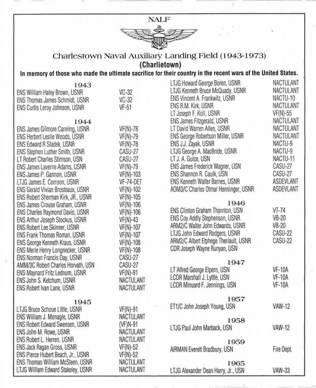
In memory of those who made the ultimate sacrifice for
their country in the recent wars of the United States
Thru these portals pass the hottest pilots in the world
— — Map (db m114952) WM
South of this spot is located Fort Ninigret marked by the State of Rhode Island as a memorial of the Narragansett and Niantic Indians. The unwavering friends and allies of our fathers. — — Map (db m31988) HM
Text on the Front (North) Side of the Monument:
Erected by the
State of Rhode Island
In Memory of
General Joseph Stanton Jr.
First U.S. Senator from Rhode Island
Under the Constitution from . . . — — Map (db m88151)
U.S. Navy
NAAF
Charlestown, R.I.
On Friday, March 2, 1945 at 2215 hours, Grumman F6F-5N Hellcat Buno
71418 crashed shortly after takeoff from runway 22, where it exploded and burned on the ice-covered waters 500 Ft off . . . — — Map (db m114948) HM
This American Liberty Elm was named after "The Liberty Tree: Our Country's first Symbol of Freedom." On the morning of August 14, 1765, the people of Boston awakened to discover two effigies suspended from an elm tree in protest of the hated . . . — — Map (db m114946) HM
From the 1600s to the mid-1900s, Ninigret's
lands were used for farming and sheep grazing.
During World War II, the U.S. Navy converted
these farm fields to the Charlestown Naval
Auxiliary Landing Field, known to young pilots
as . . . — — Map (db m306174) HM
After the glacier receded, indigenous peoples lived here during the warmer months, moving inland in the winter to villages surrounded by forest. They lived in this diverse ecosystem hunting deer, bear, moose, fowl, seals, and whales; fishing and . . . — — Map (db m306170) HM
Attacked
within their fort upon this island
the Narragansett Indians
made their last stand
in King Philip's War and
were crushed by the united forces
of the Massachusetts Connecticut
and Plymouth Colonies
in the
“Great Swamp Fight” . . . — — Map (db m300554) HM
Four score and seven years ago our fathers brought forth on this continent, a new nation, conceived in Liberty, and dedicated to the proposition that all men are created equal.
Now we are engaged in a great civil war, testing whether that nation, . . . — — Map (db m138220) HM WM
This Memorial Monument is dedicated to those who have served in the Armed Forces so that we may live in peace and freedom from fear. — — Map (db m66421) WM
Dedicated to all Patriots, particularly those who pledged their lives, their fortunes and their sacred honor so that we may enjoy the freedoms of this great land. — — Map (db m152522) WM
In faithful memory of the veterans of all Wars of the United States of America, the Rhode Island State Society of the Daughters of the American Revolution established this”Patriots Memorial Grove” 1979 — — Map (db m152521) WM
Jewish War Veterans of the United States of America Department of Rhode Island and Ladies Auxiliary.
Dedicated in Memory of all departed comrades who served their country in time of war to preserve freedom and human rights.
To honor their . . . — — Map (db m66425) WM
The lonely lookout through all weather searching the sea and sky for the enemy. The Signal Men and radio men communicate to ships in the convoy, while gun crews stand ready. A tribute to these brave men whom the world is indebted, these men must not . . . — — Map (db m66423) WM
To have struggled for freedom and to have sacrificed ones gift of life for his fellow man is service of the highest order. For such selflessness thoughtful men will be eternally grateful.
(Four Panels going from left to right)
(Panel 1) Medal . . . — — Map (db m66438) HM
(Inscription under the statue) Rhode Island National Guard
(Left Panel) Army National Guard-Since 1638-The Rhode Island Army National Guard was formed as a State Militia for the protection of the people. It always answers the call to arms when . . . — — Map (db m66428) WM
The U.S. Navy Armed Guard
The division of the U.S. Navy that dealt with the protection of merchant vessels from attacks by submarines and aircraft was known as the Armed Guard.
The armament of the merchant vessels started with one gun in . . . — — Map (db m66424) WM
Here for more than a century was the religious, business and civil center of Westerly. Near by in private homes, the people met in town meetings. Here crossed paths from what is now Hopkinton, Richmond and Westerly. Here were the first mill dam and . . . — — Map (db m29616) HM
Seventh Day Baptists, members of a church of like faith in Newport, Rhode Island until 1708, first worshipped in this community in 1672. The first meeting house was built in 1680. The nearby-by church, which replaced the original building, was . . . — — Map (db m30392) HM
This monument is a memorial to the early pastors of the Second Seventh-day Baptist Church in America, whose remains lie buried within the enclosing circle. They were stalwart men and sound preachers. They . . . — — Map (db m30707) HM
This dam, typical of those found in some areas of the English countryside, was erected about 1765. Later, two mills, one on either side of the river used the waterpower to turn wheels for manufacturing. The remains of one of the sluice ways are . . . — — Map (db m288969) HM
The Point Judith Fisherman's Co-op was admired worldwide for the way it brought fishermen together to collectively build a prosperous port.
Galilee's world-renown business model
After World War II, Galilee entered its second . . . — — Map (db m251534) HM
Infrastructure improvements paved the way for an industry
At the turn of the twentieth century, Point Judith's Port of Galilee was a mere cluster of fishing shacks. Between wind, waves and piles of twine and traps, a handful of fishermen . . . — — Map (db m251529) HM
Even though Rhode Island is located at the southern end of the lobster's geographical range, Galilee has historically been one of New England's top lobster ports. Since the early 2000s, it has also made its mark in the emerging Jonah crab . . . — — Map (db m251538) HM
Dozens of draggers land their catch in Galilee. The fleet includes day boats that return to port each evening as well as trip boats that range hundreds of miles from shore.
Rhode Island: King of Squid
Draggers (also called trawlers) . . . — — Map (db m251540) HM
One of the largest fishing ports on the East Coast, Point Judith's Port of Galilee generates economic and recreational value for Rhode Island, celebrates the state's commercial fishing heritage, and offers opportunities for fishing businesses to . . . — — Map (db m251527) HM
The 1970s and 1980s were boom times for Galilee fishermen.
Glory days and days of reckoning for Galilee's fishing fleet.
In the 1960s, New England fishermen faced rising competition from foreign-owned "factory trawlers" operating in . . . — — Map (db m251535) HM
Galilee's spirit of open-mindedness and innovation has always given it an edge.
An industry innovates to fashion its future.
After the fleet build-up of the 1970s, New England fishermen came face to face with the finite limits of . . . — — Map (db m251536) HM
Canonchet was the son of Miantonomi and the great-nephew of Canonicus, the co-sachems who welcomed Roger Williams in 1636.
Canonchet was the war leader of the Narragansetts when the United Colonies (Plymouth, Massachusetts Bay, and . . . — — Map (db m306438) HM WM
Amnesty International is a worldwide
movement independent of all government
political factions, ideologies, economic
interests and religious creeds —- that
seeks the release of men and women
detained anywhere for their beliefs, color,
sex, . . . — — Map (db m305551) HM
Honor Roll
Town of Narragansett
World War
David Adair •
Walter H. B. Allen Jr. •
Charles W. Booth •
William Boyd •
Frank H. Brayman Jr •
Joseph A. Bristow •
Edwin L. Card •
Louis E. Card • . . . — — Map (db m126612) WM
1883-1886
The Towers is one of the most highly visible, widely known, and universally cherished landmarks in the state of Rhode Island. It recalls Narragansett Pier’s heyday as one of the foremost seaside resorts of nineteenth-century America, the . . . — — Map (db m75997) HM
Wooden Light House Established 1810
Destroyed by storm September 17, 1815 / present tower built 1857
51 feet above ground - 65 feet above water
Occulting white light - 15 second group / 17,300 candle power
A tribute to the fishermen of . . . — — Map (db m51914) HM
The S.S. Black Point was built in 1918 at Camden, New Jersey as a coal collier. She was owned by Sprague Steamship Co. of Boston, Mass. And was 369’ long 55’ at the beam and was carrying 7500 tons of coal. Captain Charles Prior was master with a . . . — — Map (db m76004) HM WM
Nearly 50% of Block Island's lands are conserved for nature and for future generations of Block Island residents and visitors to enjoy. This amazing achievement is the result of the Block Island community's strong conservation ethic and was . . . — — Map (db m251568) HM
On this spot 300 Block Island Indians were challenged to battle by sixteen men and one boy.
Here Indians held feasts making many shell heaps.
Original settlers
Ackurs • Barker • Billings • Cahoone • Dodge • Gerhig • Jason • . . . — — Map (db m251563) HM
Here original settlers lived in caves and shelters. Site of first church 1772. Pastors Oliver Dodge, Trustrum Dodge. Nearby site of first school house, windmill, pound, precious spring. Indian burying hill — — Map (db m17231) HM
Site of channel and harbor
Three piers destroyed by
hurricanes
Nathaniel Dodge
First Harbor Master, 1715
Site of Bridge Gate to
Corne Neck 1676
500 feet south — — Map (db m251557) HM
Life Saving Cart
would carry a
Hawser
A thick rope that would be pulled to a ship in distress by a smaller line which is fired from a Lyle Gun on the beach and secured to the ship. The Breeches Buoy is then pulled across and the . . . — — Map (db m251555) HM
1590 A war party of 40 Mohegan Indians was driven over these bluffs by Block Island Indians - The Manisseans. Along this shore many vessels were wrecked
S. Ann Hope • S.S. Leyden • Mars • Spartan • John Davis • Munago • S.S. Meteor • . . . — — Map (db m17230) HM
Welcome
You are standing on land that until 1928 was the site of two buildings: C. C. Ball's General Store and behind it, the Bowling Alley, both built in 1879. Because of family issues regarding ownership of land and buildings after C. C. . . . — — Map (db m251576) HM
The Pond is the healthiest and most productive coastal pond in Rhode Island. Its waters and shoreline provide important habitat for fish, shellfish, lobsters and crabs, marine mammals, and shorebirds.
Great Egret
You can see this . . . — — Map (db m251565) HM
To commemorate the transfer of Block Island from Newport County to Washington County on Sept. 17, 1963. This marker was given by the Chambers of Commerce of Washington County and dedicated on June 27, 1964. — — Map (db m251575) HM
Near this spot
House of
Trustrum Dodge
One of sixteen original settlers in 1661
1614 Capt. Adriaen Block landed and named this island "Adriaen Block's Eylant".
1636 Capt. John Oldham killed by Indians
Col. John Endicott . . . — — Map (db m251561) HM
In memory of the men of Block Island who served in the World War of 1917 - 1918
Charles Arnold •
Maurice B. Ball •
Rodel Ball •
Earle J. Barrows •
Eastman S. Brown •
George E. Burgess •
Christopher A. Champlin •
John . . . — — Map (db m252309) WM
This memorial is dedicated in honor of the men and women of New Shoreham who served in World War II 1941 ~ 1945 and in loving tribute to those who sacrificed their lives in defense of liberty
★ ★ Honor Roll ★ ★
. . . — — Map (db m252312) WM
Cocumscussoc
Archeological Site
(Smith's Castle)
Has been designated a
National Historic Landmark
This site possesses national significance
in commemorating the history of the
United States of America.
1993
National Park Service . . . — — Map (db m300543) HM
Here Were Bvried
In One Grave
Forty Men
Who Died in the Swamp Fight
Or on the Retvrn March
to
Richard Smith’s Block House
December 1675 — — Map (db m301597) HM
What is now called Rabbit Island was part of the territory of the Queen Sachem of the Narragansetts and was named "Queen's Island" by early European traders. The Sachem Canonicus allowed Roger Williams to use the island as a trading site and also . . . — — Map (db m306171) HM
In 1637 near this spot, Roger Williams set up a trading post where he dwelt for many years, trading and treating with the Narragansett Indians. His dealings so completely won and held the friendliness of the powerful Narragansett sachems that for . . . — — Map (db m305931) HM
In 1942 Rhode Islander Frank J. lafrate was a 22 year old civilian file clerk at the Quonset Point Naval Air Station. In his spare time he drew cartoons. A Navy lieutenant with the newly established 'Construction Battalions' asked if he could . . . — — Map (db m115191) HM
Getting a job with a place like Rodman Manufacturing was, for most of its employees, a dream come true. Southern Rhode Island during the middle and latter portions of the 19th century, was, like most of the nation, in the midst of a period of . . . — — Map (db m222655) HM
Although Lafayette was most certainly the center of the Rodman Manufacturing world, it was only one of the villages that Robert Rodman held sway over during his lifetime. As its owner of the Shady Lea and Silver Spring Mills in North Kingstown . . . — — Map (db m222668) HM
This property
has been placed on the
National Register
of Historic Places
by the United States
Department of the Interior
Hortense Rodman Allen House
1865 — — Map (db m222644) HM
For a place to be truly considered a village requires several vital components; buildings that serve the residents and contribute to the sense of community that the word "village" embodies. In Lafayette, virtually all those community-creating . . . — — Map (db m222662) HM
After Robert Rodman returned from the eye-opening 1876 Philadelphia Centennial Exposition, he had a clear vision of how he was going to move forward and realize his dream of being competitive with the larger broadcloth mills to the north. He . . . — — Map (db m300555) HM
Robert Rodman had been making fabric here in Lafayette or more than two decades at the time that the most advantageous set of circumstances he might have imagined occurred. the nation's elite, led by the Vanderbilt, Berwind and Astor families and . . . — — Map (db m222657) HM
Industry began here on the Shewatuck River, named after a village site of the Narragansett People, Showatucquese, "place between the small streams", in the colonial period with creation of the mill pond and the construction of a sawmill . . . — — Map (db m222647) HM
A great American artist taught by West and Reynolds. He yearned to portray our greatest citizen. His portraits embody the wisdom and dignity of Washington — — Map (db m291680) HM
Has been designated a Registered National Historic Landmark under the provisions of the Historic Sites Act of August 21, 1935. This site possesses exceptional value in commemorating or illustrating the history of the United States. U.S. Department . . . — — Map (db m65655) HM
At this “round rock,” noted Indian landmark, the original purchase of this land was made from Quassaquanch, Kachanaquant, and Quequaquenuet, chief Sachems of the Narragansetts, by Samuel Wilbor, John Hull, John Porter, Samuel Wilson, . . . — — Map (db m48053) HM
Old Washington County Jail
Kingston, Rhode Island
Has been placed on the
National Register of Historic Places
By the United States Department of Interior
1792-1858 — — Map (db m56073) HM
On January 13th, 1886, Daniel Billington Griffin purchased a certain tract of land situated in Wakefield Village from Rowland & John N. Hazard for the sum of 2,000 dollars.
This particular parcel of land was located on the corner of Post Road . . . — — Map (db m115166) HM
East side
This pillar is erected to the memory of William Jackson of Virginia, who was murdered upon this spot by ship captain Thomas Carter of Newport, Rhode Island who, having been ship-wrecked and rendered penniless thereby, and being . . . — — Map (db m29314) HM
Three Quarters of a mile to the Southward on an island in the Great Swamp the Narragansett Indians were decisively defeated by the United Forces of the Massachusetts Bay, Connecticut, and Plymouth Colonies, Sunday, December 19, 1675. — — Map (db m56046) HM
Founded in 1750 as Lotteryville
So named from the 1750 land lottery granted by the Rhode Island Assembly to Captain Joseph Pendleton to recoup the loss of his brigantine and its cargo on a return from the West Indies. Renamed Avondale in 1893 when . . . — — Map (db m30394) HM
Erected by the Samuel Ward Society, Children of the American Revolution of Westerly, Rhode Island, to mark the site of the birthplace of Lieutenant-Colonel Samuel Ward, born in Westerly, November 17, 1756, died in New York City, August 16, 1832. . . . — — Map (db m68757) HM WM
Highlights of the History
• The Watch Hill Merry-Go-Round was built by the Charles Dare Company of NYC in 1867 using overstocked rocking horses
• A traveling carnival brought the Merry-Go-Round to Watch Hill in 1883 and just left it here . . . — — Map (db m68179) HM
Park Arboretum
Wilcox Park is an Arboretum, a museum of living trees. Many of the extant trees were built into Warren Manning's original park design. The design included the planting of additional trees, using the varieties available . . . — — Map (db m226887) HM
Arthur Shurcliff
Arthur A. Shurcliff, or Shurtleff, was born in 1870. Like Warren H. Manning, the original Park landscape architect, Shurcliff also started his professional career in the Olmstead Landscape Architecture Offices. In . . . — — Map (db m226886) HM
The Bandstand
The Wilcox Park Bandstand was commissioned by the Memorial and Library Association as a performance space for the Westerly Band. It was designed and built by R.A. Sherman and Sons in 1902 and restored in 2017. The . . . — — Map (db m226851) HM
The New London Steamboat Co. operated between 1882 and 1904 providing service between New London, CT, and Watch Hill, RI and Block Island, RI. Summer visitors would take the steamboat for day trips to the beaches and to visit at the resort . . . — — Map (db m226900) HM
This is the third building for the parish of Christ Church, Westerly, organized in 1834. The cornerstone of the present building, designed in the Gothic Revival style, was laid in 1891 and the completed church was consecrated on October 16, 1894. . . . — — Map (db m226891) HM
Comfort Station
Built in the Arts and Crafts style popular at the turn of the 20th century, this Comfort Station was opened October 11, 1911. It served as a public rest room for nearly half a century. Although Comfort Stations were . . . — — Map (db m226847) HM
Frank Hamilton
Frank Hamilton, a great-great-grandson of Alexander Hamilton, was the Superintendent of Parks for New York during World War I. In 1906, Wilcox Park nearly doubled in size when the seven-acre Brown Farm was added. . . . — — Map (db m226879) HM
The Westerly granite industry began in 1846, when Orlando Smith discovered a granite outcrop on his farm. After the Civil War, the Westerly granite industry flourished due to the demand for high quality granite for monuments. This demand . . . — — Map (db m226839) HM
The home of Doctor Joshua Babcock, first physician and first postmaster in Westerly. Chief justice of the Supreme Court of the Colony of Rhode Island.
In this house was the first post office in Westerly. — — Map (db m226783) HM
In recognition of those who served in the Armed Forces during the Korean War 1950 - 1953
Major Frederick C. Roever (HQ) •
1st Lieutenant Frederick T. Rogers (Commanding Officer) •
1st Lieutenant James F. Gormally, Jr. (Executive . . . — — Map (db m226813) WM
To memorialize her husband, Stephen Wilcox, Mrs. Harriet Hoxie Wilcox purchased seven acres of land in downtown Westerly in 1898, and donated it to the Memorial and Library Association. Mr. Wilcox, a successful businessman and inventor, had . . . — — Map (db m226896) HM
Near this Spot in 1846 Orlando Smith Stonemason from the neighboring State of Connecticut, searching for Stone and superior Quality, discovered the hidden Deposit of Westerly Granite and founded here a Granite Industry.
On this . . . — — Map (db m226780) HM