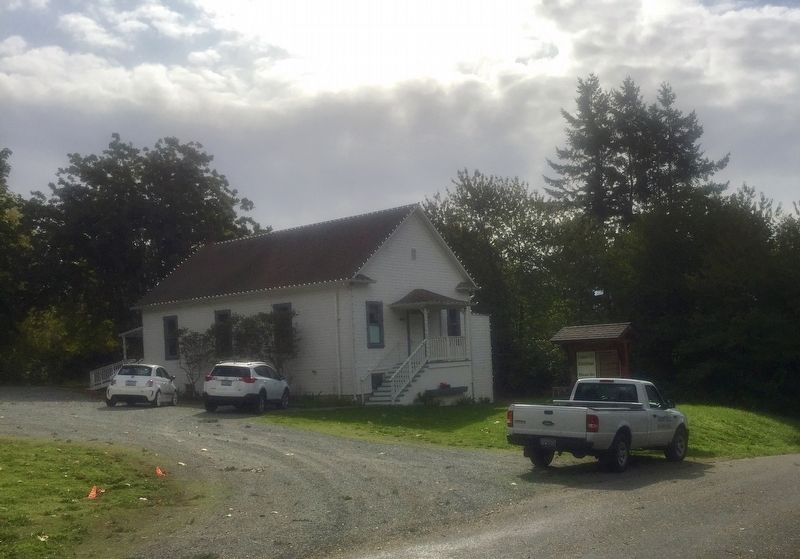
The Camano City School District #18 was formed in 1903. This
classic example of that eras "One-Room Schoolhouse” was
built around 1905, to serve the children of the surrounding
community of about 300 families.
The land was deeded to the . . . — — Map (db m143264) HM
History Of Camano/Camano City
(Early records often interchanged these place names)
In 1898 the Esary brothers with assistance from
Porter Garrison and sons established one of
Camano's major logging companies, in the area
surrounding the . . . — — Map (db m143255) HM
We extend you a warm and friendly welcome to Coupeville in the heart of Ebey's Landing National Historical Reserve!
In 1792, Captain George Vancouver sailed the HMS Discovery into Puget Sound. His first mate, Joseph Whidbey then . . . — — Map (db m179345) HM
In 1968, a seemingly simple zoning request kicked off a fight over the future of Central Whidbey Island.
When proposed development threatened to cut off access to a beloved beach and replace the heritage farmland you see today with subdivided . . . — — Map (db m196842) HM
Humans have been part of this landscape for at least 10,000 years. By the time European explorers entered the Salish Sea in the late 1700s, the Lower Skagit people had [utilized] Whidbey Island for millenia, living in mobile and established . . . — — Map (db m179286) HM
Under the provisions of the National
Historic Preservation Act of
October 15, 1966, this property
possesses exceptional value in
commemorating, or illustrating
American history
Placed on the National Register on
Dec. 12, 1973 by . . . — — Map (db m179278) HM
In honor of the founder
of Island County and his wife
Col. Isaac Neff Ebey – Rebecca Whitey Ebey
1818 – 1857 1822-1858
Whidbey Island’s first permanent settler 1850.
Proposed the separation of Island County from Thurston County . . . — — Map (db m61038) HM
On May 28, 1840 Father Francois Norbert Blanchet came to Ebey's Landing, from his Cowlitz Mission. The visit was in answer to a request by Chief Tslalakum to come and teach his people the new religion.
He was received with great joy by the . . . — — Map (db m179284) HM
This Douglas Fir is about
700 years old. It would,
therefore, have been a
sapling about 200 years before
Columbus discovered America.
—————————————
Restored October 1986
This slab was found near Perrigo's Lake in the early 1930's . . . — — Map (db m179324) HM
You are standing in the nation's first historical reserve, a unique unit of the National Park Service.
The Reserve was originally championed by a group of concerned residents in the 1970s when Ebey's Prairie was subdivided for large-scale . . . — — Map (db m179320) HM
Ebey's Landing, the nation's first National Historical Reserve, was established by Congress in 1978 "in order to preserve a rural community which provides an unbroken historical record from nineteenth century exploration and settlement in Puget . . . — — Map (db m179349) HM
Places to visit
1 Island County Museum
908 NW Alexander Street
The Island County Museum features local and regional history. Ice Age relics, woolly mammoth remains, a Native American collection that includes . . . — — Map (db m179321) HM
A Glimpse In Time
Like the majority of the coastal forts built in the United States, Fort Casey never fired its guns in warfare.
Fort Casey is one of three coastal forts constructed in the late 1890s to defend the entrance to Puget Sound . . . — — Map (db m61063) HM
Penn Cove and Coupeville are home to the Schooner SUVA, during sailing season. See her moored at the historic wharf.
A FAMILY YACHT
In 1925, Frank J. Pratt Jr. had SUVA built in Hong Kong. Her old growth Burmese Teak hull and . . . — — Map (db m179319) HM
...came to Whidbey Island in 1895 as a young lawyer and stayed, having been struck with a life-long love of its beauty. Served as Island County Prosecuting Attorney 1896-1907, and Superior Court Judge for Clallam, Island, and Jefferson Counties . . . — — Map (db m179283) HM
History
The Alexander Block house is one of four blockhouses remaining in Central Whidbey Island. Few original blockhouses of this type remain throughout the United States. John Alexander, Sr. built this blockhouse on his donation land claim . . . — — Map (db m60986) HM
Left side of marker is written in Gaelic and right side is in English
Died here. April, 9 AD 1861
One year ten and twenty
(years) of age
Born at Mineth, Ireland
Gentle wife (of) Sam’l Maylor
They married in Liverpool
At the . . . — — Map (db m60979) HM
From the end of the Lake Ozette Road, 2 trails lead to the ocean beaches. One, the Indian Village Trail, leads to the site of an abandoned Ozette Indian village at Cape Alava. For over 2000 years, Cape Alava was home to the Makah Indians. . . . — — Map (db m179353) HM
Saved Blockhouse
In 1921 a local civic group, the Ladies of the Round Table (LORT) began a ten year effort to restore the decaying Davis Blockhouse. Local carpenter Fred Krueger handled the project carefully replacing rotting beams while . . . — — Map (db m60991) HM
Donation claim of Jacob Ebey.
Served in War of 1812, the Black Hawk War and the Mexican War.
When 61 yrs old led company across plains with covered wagons.
Settled on Whidbey Island and built this home, four blockhouses and stockade in 1856 . . . — — Map (db m60977) HM
Sudden Indian attacks at Seattle and Bellingham in 1855 caused consternation among the small pioneering settlements on Puget Sound. The tradition of blockhouse defense was well known to American settlers, dating from the earliest English colonies. . . . — — Map (db m61040) HM
Ferryboats have been active on Puget Sound since January 1, 1889. The City of Seattle offered the first scheduled service between Seattle and West Seattle; a bargain at 5 cents per passenger!
The Washington State Ferry System traces . . . — — Map (db m179348) HM
The Coupeville Wharf was built in 1905 in response to the increased economic, military and social activities in the area, and was one of several that supported the busy shipping commerce to and from Whidbey Island.
In the late 1800s, sailing . . . — — Map (db m179287) HM
Died in Service
Harvey Baker · Camano • Glenn E. Muzzall · San de Fuca
Ernest Knowles · Crescent Harbor • George B. Morris · Smith's Prairie
Math. L. English · Fort Casey • Harry Nourse · Maxwelton
Harry Burton · Langley • . . . — — Map (db m179280) WM
The cottage was actually built as two separate buildings. The eastern half was built as a law office for James Zylstra. The western half was added and the building became the medical office for Dr. Chas. White. In 1998 Rev. Barry Burton & Capt. Mike . . . — — Map (db m61037) HM
The swirling waters that pass in and out of the narrow channels between Whidbey Island and Fidalgo Island have captivated visitors to this area for thousands of years. Salish Native American tribes were the first human inhabitants of these . . . — — Map (db m74012) HM
It's hard to imagine Deception Pass without the bridge. But until 1935, the gap between Fidalgo Island and Whidbey Island could only be crossed by boat. In 1924 a small ferry called the Deception Pass began running between Yokeko Point . . . — — Map (db m74083) HM
When the federal government transferred 1,700 acres of land on Fidalgo Island and Whidbey Island to the State of Washington in 1925, Deception Pass State Park was barely an idea. For decades, the land had been a military reservation set aside . . . — — Map (db m74085) HM
Built by Richard Luhn
on the site of Anderson's
blacksmith shop. Housed his
realty and a dentist's office.
Robert Smith's "First Properties"
realty followed. Lawyer Tim Martin added an addition in
1982. Waterman Enterprises, Inc. bought the . . . — — Map (db m195450) HM
Built in 1939 on the site
of Langley's first hotel
that burned in 1921, it
served as the Post
Office until 1960.
It next housed a
laundry, pottery studio,
appliance repair shop, wine shop, antique store,
and flower shop, before becoming . . . — — Map (db m195443) HM
Joe Primavera founded
the Star Store in 1919
as a shoe repair
business in his home at
Second Street and
Anthes Ave. He
moved the business to
First Street in 1922.
Joe, wife Martina and son Victor are standing in
front of the new 1929 . . . — — Map (db m195446) HM
Frederick Tiemeyer ran a
bakery here from 1925 to
1944. His nickle
butterhorns were very
popular.
The building next housed
linoleum and furniture
stores, beauty and barber
shops, and several other
businesses before becoming the Cafe . . . — — Map (db m195445) HM
Dedicated to all U.S. Navy Patrol and Reconnaissance Naval Aviators, Naval Flight Officers and Aircrewmen who, for the cause of freedom, have made the ultimate sacrifice.
Special thanks to Mr. John Christiansen for his many contributions to . . . — — Map (db m74000) HM WM
Family Origins
This park is named after the family of Egbert and Betty Beeksma in recognition of the business they started on the site of park and their contribution to the development of Oak Harbor.
Egbert Beeksma was born the Netherlands . . . — — Map (db m60940) HM
Before the bridge was completed in 1935, the only way to cross Deception Pass was by boat.
If you wanted to take your car from Whidbey to Fidalgo Island in 1929 your crossing would look like this, aboard the MV Acorn.
Your captain could . . . — — Map (db m61465) HM
Named by Captain George Vancouver 10 June 1792. Feeling that he had been “Deceived” as to the nature of the inner waterway, Port Gardner (now Saratoga Passage) he wrote on his chart “Deception Pass”. He . . . — — Map (db m60904) HM
To the north of this narrow passage is Fidalgo Island, so named for the Spanish explorer, Lieutenant Salvador Fidalgo. To the south is Whidbey Island, second largest island in the contiguous 48 states, which Captain George Vancouver, while exploring . . . — — Map (db m60903) HM
This Navy flagstaff is placed here to honor all those Navy people who have served aboard the Naval Air Station on Whidbey Island, their families, and the people of Oak Harbor who have long supported the Navy mission.
Our National Ensign was . . . — — Map (db m73990) HM WM
Oak Harbor’s early “town” was built along the waterfront, and stretched from Maylor’s store along Pioneer Way to about a block east of the junction of Flintstone Freeway and Midway and Pioneer.
The east end of the town burned in a . . . — — Map (db m60938) HM
'Why do we love the sea? Because she has the power to make us think things we like to think.'
- Robert Henry
The Old Wharf and Steamships
Look offshore toward Maylor's Point and you will see a concrete block that remains from Oak . . . — — Map (db m73991) HM
The Skagit Indians maintained several villages on Penn Cove. The paramount Skagit chief lived at Snakelum Point, southeast across the cove. The village at Monroe’s Landing was called cokwol’a. Cokwol’a was a major village of the Skwdabs, a subgroup . . . — — Map (db m61074) HM
Built 1914
Designated a City of Auburn Landmark 1995
The development of this local public library building was part of a national movement spurred by the philanthropy of iron and steel magnate Andrew Carnegie. In 1911, the Auburn Library . . . — — Map (db m197164) HM
Inspired by the park's many resident crows, this clever corvid reminds us that a drive-in restaurant once stood at this site. Intended as a whimsical landmark for
Auburn's beloved Les Gove Park, this sculpture is meant to capture the attention of . . . — — Map (db m224098) HM
The Ballard Avenue Landmark District holds a significant place in Seattle history. The uniquely-preserved state of Ballard Avenue provides visitors with a window into the heyday of Ballard’s industrial and commercial era.
The City of Ballard . . . — — Map (db m27976) HM
Bellevue Downtown Park, a 20-acre oasis in the heart of Downtown Bellevue, is a gathering place that connects Downtown Bellevue and the Meydenbauer Bay waterfront. It provides places for active and passive recreation, and is a prime location for . . . — — Map (db m266193) HM
This garden is a living tribute to all
of America’s Veterans and their
families in silence and respect, this is
a place to remember why millions of
Americans have fought and died for
our liberty and our freedom.
Here we renew our promise to . . . — — Map (db m296345) WM
This brick facade is part of the original structure that housed the historic Bothell Cooperative Mercantile Company.
In 1906, a group of merchants, teachers, and farmers founded the co-op and built the long-standing brick store in 1908. The Merc . . . — — Map (db m272454) HM
In the late 1850’s under the leadership of the Secretary of War Jefferson Davis, Military Road was constructed between Fort Vancouver and Fort Bellingham,
continuing north of Seattle, skirting the swamps of the Sammamish Slough. The portion of the . . . — — Map (db m254933) HM
Here lived and gave her service to mankind
World's Champion Milk Cow
Born 1913 - Died 1925
Twice she registered production records that set her fame above all dairy cattle of any age. In each of two years she exceeded 16,500 quarts of milk, . . . — — Map (db m303152) HM
Designated a City of Carnation Landmark 1994
The old Tolt Oddfellows Lodge Hall has been an integral part of community life in Carnation since its construction. It was built by IOOF Lodge No. 148 and subsequently became the Eagle's Hall. The . . . — — Map (db m303154) HM
Presented April 24, 1926
Dedicated Aug. 20, 1933
by
Seattle, Tacoma & Associated
Young Men's Business Clubs
Co-Sponsors
Seattle Star and Tacoma Times
9-10-39 — — Map (db m180095) HM
The Saar Pioneer Cemetery is named for former King County Councilman Peter Saar, who in 1873 buried his wife on a small hill on their homestead. Since that time the cemetery has been known by many names.
Kent Cemetery • Kent Methodist Cemetery . . . — — Map (db m52568) HM
Leslie and Alicia Forbes opened Juanita Beach resort in 1921. They and their five children: Dorris, Betty, Joyce, Joanne, and Dorr ran the beach for 35 years. The 20’s and 30’s were exciting and busy years with thousands of visitors coming to the . . . — — Map (db m266201) HM
Prior to 1916, Lake Washington’s shoreline reached today’s Juanita Drive. When Lake Washington was lowered, a vast, sandy expanse was revealed on the north side of Juanita Bay. Leslie and Alicia Forbes erected a small bathhouse and established a . . . — — Map (db m266197) HM
Originally paved in 1913, the road was part of the transcontinental Yellowstone Trail connecting Boston and Seattle, and which is now the longest remaining stretch of brick highway in King County. — — Map (db m176611) HM
The Celebration Rose Garden was initiated in 2004 by the Seattle Rose Society through the vision and efforts of Seattle Rose Society member Lori White.
The planning and maintenance of the Rose Garden during its early years was carried on . . . — — Map (db m178625) HM
The story of the Elda Behm Paradise Garden is also the story of the Highline SeaTac Botanical Garden.
It is the story of Elda's love of gardening and how a community came together to express and share that love. Many of the plants in the . . . — — Map (db m178573) HM
These roses honor the legacy of the women
who made history on our Home Front during WWII.
They are part of a national "Living Memorial" to inspire
a new generation of 21st century Rosies. — — Map (db m178624) HM
Seike Family History
Shinichi Seike immigrated from Ehime, a southern Japanese island, in 1919 and ran an import/export business in Seattle. In 1929 he purchased 13 acres near Des Moines Memorial Drive and moved into a farmhouse along with . . . — — Map (db m178673) HM
Presented by
The Exchange Club of Highline
To the P.O.W.-M.I.A. Memorial Plaza
Washington Memorial Park.
September 19, 1992
[Historical Documents in U.S. History,
listed chronologically]
The Mayflower Compact
The Mayflower . . . — — Map (db m178541) HM
This Victory Garden or Food Garden for Defense was planted in 2019 in commemoration of the over 20 million victory gardens planted across the U.S. during World War II. The orchard in the Neighborhood Heritage Garden is over 50 years old and was . . . — — Map (db m178622) HM
Purser, mate, trader, Shipowner, venturer, Joshua Green began his waterfront career on Puget Sound in 1888 when steamboating was in its infancy. He founded the LA Conner Trading and Transportation Company, operating freight and passenger steamers, . . . — — Map (db m294122) HM
America's oldest continually operating movie theater opened on this historic site in 1914 as the Majestic. In 1929, as the Roxy, it featured "talkies." In 1946, it became known as the Bay. In 2000, with the opening of The Majestic Bay, we start a . . . — — Map (db m294121) HM
Multiple plaques on and near the Ballard Centennial Bell identify the Ballard Avenue Historic District.Marker 1:
Be it remembered that at this place on the eleventh day of April, Nineteen Hundred and Seventy Six, the Ballard . . . — — Map (db m168325) HM
This commemorative centennial tree was planted to celebrate the annexation of Ballard to the City of Seattle on May 29, 1907.
Mayor Greg Nickels
May 29, 2007 — — Map (db m294644) HM
Built by Ballard saloon entrepreneur Louis Anderson, this structure was originally home to Warren Brothers Drug Store. In 1912 Samuel and Lewis Barthelemy opened the well-known Ballard Hardware and successfully conducted business from here for . . . — — Map (db m181484) HM
Considered one of the largest moving companies in the area, Ballard Livery and Transfer was established on Leary Avenue in 1904. Its office was moved to this location in 1907, when B.J. Cooney took over the business. A year later the Boyd Brothers . . . — — Map (db m181485) HM
The original owner was Louis Chopard, a partner in Chopard and Cosgrove Wholesale and Retail Liquors, who ran his successful business in downtown Seattle. In 1901 Nicholas Theisen purchased this property and maintained ownership until the late . . . — — Map (db m181441) HM
Through the 1890s this was the most imposing structure in Ballard. It was built in 1893 by William Cors and Robert Wegener, proprietors of the Ballard Wine House. These two men first became business associates in 1889 and opened the Wine House a . . . — — Map (db m181461) HM
Built for Fitzgerald and Hynes Department Store for a total of $15,000, this building was dedicated in February of 1909. The department store was located on the ground floor. The Ballard Aerie of Eagles leased the entire upper floor for what was . . . — — Map (db m181473) HM
In 1898 Swedish merchant tailors Frank and Arthur Enquist opened their first tailor shop down the street in the Swanson Block at 5140 Ballard Avenue. Through their success at that location, they were able to build this classic brick structure in . . . — — Map (db m181474) HM
Stephen Battleson, secretary and treasurer for the Horse Shoe Mining Company, with his sisters Olga and Emma, constructed a modest storefront here in 1905. It was initially occupied by Dr. A. J. Douglas's optical manufacturing business and P. . . . — — Map (db m181482) HM
Louis Anderson began his illustrious career in Ballard as a barber in 1891. He quickly became involved in the thriving saloon business, fronting bonds for various bar owners' liquor licenses. By 1902 he had opened his own saloon, the Fremont Saloon, . . . — — Map (db m181479) HM
This fine example of Romanesque architecture was built in 1901 and named in honor of Gustavus B. Sanborn, a pioneer Ballard businessman. Sanborn began his career as a carpenter in 1891. He owned a series of hardware stores on Ballard Avenue in the . . . — — Map (db m181481) HM
In 1920 Charles and Edna Halverson built this structure to house their Ladies and Gents Furnishings Store, which they ran successfully for thirty-four years. Shortly after opening the store they expanded their retail focus to include dry goods. . . . — — Map (db m181476) HM
Built by Swan Hansen, the president of the Horse Shoe Mining Company, this elegant brick structure was home to the Henry Brothers Saloon (Charles and Lewis). By 1908 the Pederson and Olsen Bar took up residence on the ground floor and stayed until . . . — — Map (db m181487) HM
When dedicated on July 4, 1917, the Hiram M. Chittenden Locks was the largest navigation facility in North America. During the dedication, the USS Roosevelt - flagship for Commodore Robert Peary's famous 1909 expedition to the North Pole - led a . . . — — Map (db m86455) HM
Built by Seattle saloon owner Stephano Raggio in 1904, the Junction Building originally stood three stories tall with a crenellated turret. Unfortunately, fire destroyed the third floor, requiring its removal. In the early 1900s the ground floor was . . . — — Map (db m181465) HM
Brothers Charles and Richard Kutzner built this stately brick and sandstone structure in 1904 to house their Tonsorial Parlor, a successful barber shop that was formerly located in downtown Seattle. The Kutzners operated their business out of the . . . — — Map (db m181471) HM
plaque one:
Dedicated in Honor of
Marvin Sjoberg
Mayor of Ballard
April 4, 1975
plaque two:
Marvin Sjoberg (born April 4, 1921 – Died February 26, 1989) was a colorful resident of Ballard Avenue. He was given the . . . — — Map (db m294639) HM
Originally only two stories tall, this Neoclassical Revival building was financed by Albin and Oscar Matthes, proprietors of the Old Home Saloon. In 1905 the Fraternal Brotherhood of the Elks purchased the building and occupied the upper floor. The . . . — — Map (db m181466) HM
The Ballard Historical Society and the Seattle-Bergen Sister City Association joined together to create this mural in 1995 to commemorate our community’s rich and prosperous history, and to celebrate our economic and cultural ties to . . . — — Map (db m27794) HM
Tacoma residents James and Welthia Kelsey built this one-story building in 1903 as an investment. They entered into an agreement with Eugene Felt, the owner of the Felt Block next door, to create an internal opening between their two buildings . . . — — Map (db m181472) HM
Longtime Ballard bar owner Charley Swanson built this structure in 1904 and opened the Owl Saloon here with his partner Leonard Strygen. Except for the years during Prohibition, when the Owl Cafe occupied the ground floor, this building has . . . — — Map (db m181460) HM
Alfred Palmer, proprietor of Alfred Palmer and Sons Real Estate Company in downtown Seattle, owned this building for more than three decades. Valued at $3,890 in 1905, the property was one of the more impressive structures in what was known as the . . . — — Map (db m181440) HM
Built by prosperous Norwegian miner Martin Markusen, this vernacular sandstone and brick building first housed the St. Paul Hotel and later the Princess Hotel on its upper floor. Groceries and meat markets occupied the ground floor storefronts . . . — — Map (db m181478) HM
For over two decades the Ballard branch of the Scandinavian-American Bank operated out of this Second Empire Baroque structure, which was built in 1902. Originally incorporated in 1892, the bank's main branch was located in Seattle and boasted of a . . . — — Map (db m181468) HM
In 1891 William Curtiss built a modest structure on this site to house his tinware and stove manufacturing and sales business. By 1909 he had expanded his inventory to include a wide variety of hardware products and in 1911 he constructed the . . . — — Map (db m181464) HM
A grant from philanthropist Andrew Carnegie helped to underwrite construction cost, also with money raised by local citizens & businesses at the time.
This building has not been a library since 1963
This building is on The National Register . . . — — Map (db m298501) HM
In 1901 Nicholas Theisen started his liquor store in the adjacent Chopard Block. Known as the California Wine Company, it featured "a high grade of California wine." Through the success of his business Mr. Theisen was able to construct the Theisen . . . — — Map (db m181442) HM
735 entries matched your criteria. The first 100 are listed above. Next 100 ⊳