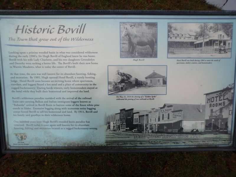
Looking upon a pristine wooded basin in what was considered wilderness in the early 1900’s, Sir Hugh Bovill of England knew he was home. Bovill with his wife Lady Charlotte, and his two daughters Gwendolyn and Dorothy were seeking a better life. . . . — — Map (db m113704) HM
Built in 1890, this is the original site of the Moscow National Bank which closed in 1896 and then successive banking ventures until 1936. — — Map (db m122021) HM
Like this Long Highway, the University of Idaho links together the northern and southern parts of the state of Idaho.
Established by the territorial legislature, Jan. 30, 1889, the university opened in the fall of 1892.
As Idaho’s land . . . — — Map (db m109682) HM
Built as a model town, Potlatch was owned by Weyerhaueser's Potlatch Lumber Company.
Spokane architect C. Ferris White designed the new community in 1905.
Workers’ housing stood close to the mill.
Managers’ homes were built away from . . . — — Map (db m109672) HM
Trail of the Coeur d’Alenes
Trail of the Coeur d’Alenes is a 73 mile long bike trail built on the original Union Pacific railroad grade.
During 1884 silver was discovered in the valley.
During 1888, construction began on a rail line . . . — — Map (db m110413) HM
Potlatch Lumber Company's sawmill built here in 1906, was one of the largest in the world.
Expanding operations to the West, Weyerhaeuser timber barons invested in Idaho’s prime white pine stands.
By 1920, their mill was cutting 175 . . . — — Map (db m109673) HM
In 1863 this area was a “Shebeen” (outlaw headquarters) and murder and robbery of travelers were common place. This valley was on the main and original Nez Perce Trail leading into Montana through Elk City. Homesteaders moved into the . . . — — Map (db m121589) HM
When he came to Lewiston in 1867, Father J.M. Cataldo developed a Jesuit Nez Perce mission that continued long after he founded Gonzaga University in Spokane.
A chapel was built a mile up Mission Creek in 1868, but a permanent location . . . — — Map (db m109654) HM
Here the resting place for three generations of Bredells overlooks the river terrace where they lived from 1861 to 1927. The cemetery’s location next to a parking lot may appear unusual, but the Bredell family was part of a thriving Nez Perce . . . — — Map (db m121639) HM
The basalt arch on the hillside across the road depicts támsoy ka・?alatálo, insects Ant and Yellowjacket, locked in combat. Many features in this river valley relate to nimi・pu・ (Nez Perce) traditional stories. . . . — — Map (db m121414) HM
According to a Nez Perce Indian legend the stone arch up the hill was once two fighting insects.
Ant and Yellowjacket had an argument and came to blows over who had the right to eat dried salmon here. Fighting fiercely, they failed to notice . . . — — Map (db m121412) HM
This small train stop linked the Nez Perce with the cities of Lewiston, Idaho, and Spokane, Washington. Running directly through the reservation, the rails also opened this area to a wave of farmers and loggers who made striking changes to Nez Perce . . . — — Map (db m121736) HM
Located Sept. 15, 1846 by William Craig mountain man and his Indian wife Isabel.
First permanent white settler in Idaho, 1840, first Nez Perce Indian Agent, 1848; interpreter at Walla Walla Flathead and Blackfoot Councils, 1855 Lieutenant . . . — — Map (db m121603) HM
The Indian Agent, representing the United States Government, lived here side by side with the Nez Perce. By law the agent and the government were responsible for upholding the terms of treaties. Duties included building schools, distributing food, . . . — — Map (db m121735) HM
Henry Harmon Spalding established Idaho’s earliest mission near here, Nov. 29, 1836, at a site chosen by the Nez Perce Indians.
Ever since they met Lewis and Clark in 1805-6, the Nez Perce had wanted to find out more about the white . . . — — Map (db m121638) HM
Generations of Nez Perce people are buried here, as well as Henry and Eliza Spalding and other missionaries and agents. To the Nez Perce this is sacred ground -- part of their connection to a traditional homeland. This is still an active . . . — — Map (db m121641) HM
The river terrace below had the ingredients for a thriving village site: fresh water, a river full of fish, and a stream corridor filled with wildlife. For thousands of years the Nez Perce lived a life of bounty here. Then within a 50-year span . . . — — Map (db m121640) HM
In Memoriam
Rev. Henry Harmon Spalding
1803 - 1874
and his wife
Eliza Hart Spalding
1808 - 1851
Pioneers, Missionaries, Founders of
Industry
Education
Religion
and Christian Citizenship
among the
Nez . . . — — Map (db m121645) HM
The First Home, The First School and the
First Church in Idaho.
Established by
Rev. Henry Harmon Spalding and
Eliza Hart Spalding — — Map (db m121643) HM
Inspired by Henry and Eliza Spalding’s missionary zeal, this church held its first service in 1876. A number of Nez Perce embraced Spalding’s religion. Soon there were Nez Perce ministers, hymns in the Nez Perce language, and Indian blankets and . . . — — Map (db m121763) HM
Watson’s store was typical of country stores that served small communities on the Nez Perce reservation in the early 1900s. The inventory included groceries and hardware, yet Watson’s also had stocks of beads for decorative work and canvas for tipis . . . — — Map (db m121738) HM
“A bluff jolly good fellow.” He joined the rocky mountain fur trade in 1829, married a Nez Perce in 1838, and settled with the Lapwai Band in 1840.
In 1850 the Oregon Donation Land Act gave free farms to pioneers who had come to . . . — — Map (db m121592) HM
In 1898, after rail service from Lewiston reached Lenore, a tramway was begun to ship grain from Camas Prairie (1600 feet above) to a new freight stop directly across the river.
Previously, grain wagons descended a long steep hill from the . . . — — Map (db m289680) HM
Household and family groups were the heart of Nimiipuu, or Nez Perce society.
Families lived and worked together, forming social alliances with others.
Each Nez Perce – man, woman, child – uniquely contributed to the common good.
Village . . . — — Map (db m110701) HM
Served as the steamboat port for the Clearwater Gold Rush which followed mineral discoveries at Pierce in 1860.
Founded by Seth S. Slater, May 6, 1861, Slaterville (permanent population, 50) had 5 edifices – built mainly of colored . . . — — Map (db m289679) HM
Lewiston's first bridge across the Clearwater River was constructed in 1913 and replaced in 1951.
Early efforts for a bridge were opposed by ferryboat owners, but other business leaders recognized the need for a link to northern . . . — — Map (db m109711) HM
Piloted by Ephraim W. Baughman, the Colonel Wright was the first sternwheeler to ascend the Snake River to its junction with the Clearwater.
After the strong current snapped the boat’s tow line at Big Eddy (present-day Lenore), the Oregon . . . — — Map (db m110588) HM
The Corps of Discovery reached the confluence of the Snake and Clearwater Rivers on October 10, 1805.
In his map of the site, William Clark included a small island he observed “at the point of union” of the channels.
The island . . . — — Map (db m110632) HM
Noted pilot and founder of Idaho's first airline. His skillful flying, zest for adventure, pioneer spirit and mercy missions left an aviation legend.
He was a man of remarkable energy, resolution and result -- yet, withal a modest and . . . — — Map (db m122020) HM
A Nez Perce Indian legend tells how Coyote and Black Bear had a falling out while fishing here long ago.
Coyote, the all-powerful animal spirit, was having a good time until Black Bear, the busybody, began to tease him. Finally losing . . . — — Map (db m109727) HM
No Tents?
By the time members of the Lewis & Clark Expedition reached the Snake River, their night-time shelter consisted of buffalo robes and other skins.
They left St. Louis with tents of oiled canvas, but by the summer of 1805, those . . . — — Map (db m110578) HM
Seasonal Migrations
The Nimi’ipuu migrated throughout the region of the Snake River and its tributaries.
They traveled seasonally to take advantage of the food sources: camas bulbs, berries, deer, elk, bear, and salmon.
Their mobility . . . — — Map (db m110541) HM
In this vicinity
was the first deeded land in Lewiston
1861
First homes, post office, courthouse, jail, mill, Masonic Hall, opera house: and first classes in State Normal School. 1896. — — Map (db m121915) HM
”This river is remarkably clear and crowded with salmon in maney places…
Salmon may be seen at the depth of 15 or 20 feet…
The number…
Is remarkable to say.”
~Captain Wm. Clark
The Nimi’ipuu relied upon . . . — — Map (db m110687) HM
The original territory encompassed an area of 324,000 square miles – an area larger than Texas – and included all of present day Montana, virtually all of Wyoming, including western strips of North Dakota, South Dakota, and Nebraska. . . . — — Map (db m96492) HM
Pioneer businessman and politician,
he owned and operated ferries in the Lewiston and Spokane areas.
Early in the 1860’s, John Silcott ran a ferryboat across the Snake River at Lewiston.
He soon put in a ferry across the Clearwater River . . . — — Map (db m109713) HM
H.C. Kettenbach, Lewiston businessman, built this block in about 1907, probably to replace an earlier Kettenbach building which had housed a pioneer Lewiston newspaper, the Lewiston Teller. Lewiston City Officies occupied the building in its earlier . . . — — Map (db m121916) HM
The first white men to cross this country and reach the Pacific Ocean via Lolo Pass and present site of Lewiston. They came and returned the way that leads you are now on the Lewis and Clark Highway along the Clearwater River - the . . . — — Map (db m121815) HM
Lewis Clark State College was created by the legislature in 1893 as a two year normal school to train teachers.
After more than half a century of growth, Lewiston State Normal School expanded into a four-year college in 1947.
An area . . . — — Map (db m109721) HM
When automobile traffic made steep old wagon roads obsolete, a remarkable new highway grade was built down this hill in 1917.
With a series of sharp curves that let cars go 20 or 30 miles an hour -- a good speed for that time -- a gradual . . . — — Map (db m121917) HM
The discovery of gold in 1860 and the founding of Lewiston in 1861 attracted many Chinese to the area.
By 1870 approximately 1500 Chinese lived here. They worked as merchants, laborers, laundrymen and vegetable farmers. Exhausted gold fields, . . . — — Map (db m121808) HM
Early in September 1812, Donald Mackenzie set up a fur trade post near here for John Jacob Astor's Pacific Fur Company.
Disappointed to find that beaver were unavailable in this area, he built only a store and two houses out of . . . — — Map (db m109724) HM
At the turn of the century, Mark A. Means, who had arrived by horseback in 1881, and stayed to amass a fortune, hired Lewiston architect J.H. Nave to build a structure to house the various enterprises Means had in mind.
Built of white pressed . . . — — Map (db m121812) HM
This important archaeological site - occupied for 10,000 years or more has at least 10 pit houses as much as 5000 years old.
Two styles of houses were used. Some were fairly square with interior benches dug out for use by a family or . . . — — Map (db m109725) HM
This scenic route commemorates the Lewis and Clark expedition’s quest for a watercourse through the Rocky Mountains connecting the Missouri and Columbia rivers.
The byway parallels the explorers' journey through the ancestral Nez Perce homeland in . . . — — Map (db m109726) HM
The south section, which for many years housed City Hall, was built in 1909. The north section, once the city fire station, was built between 1918 and 1928. This simple commercial style is suggestive of Renaissance Revival. Many of its original . . . — — Map (db m121910) HM
A two-story commercial building built of concrete with massive timber framing with orange and buff brick veneer. In its classical entryway and its use of classical symmetry and balance the building is suggestive of Renaissance Revival style. . . . — — Map (db m121911) HM
Said to date from the late 1860s, this historic log cabin is Lewiston's oldest surviving residence and once sat on 19th Street between Main and G Streets. The first documented owner was Samuel C. Thompson (1820-1898), who came to Lewiston in 1862 . . . — — Map (db m121909) HM
Lewiston's leading hotel in the 1860's. Way station on the road to the Idaho gold fields. Hill Beachey, famed apprehender of the Magruder murderers, was it's first proprietor (1861-1864).
Focal point for much of Lewiston's history during the . . . — — Map (db m121816) HM
Marcus Whitman and Henry Harmon Spalding led Presbyterian Missionaries West in 1836 to answer a Nez Perce call for teachers.
Spalding began his mission and school nearby, but moved here in 1838. Believing in secular as well as religious . . . — — Map (db m109729) HM
Started May 13, 1861, as a steamboat landing, Lewiston immediately became a primary commercial center for Idaho miners during their hectic gold rush to Pierce that spring. Steamboats continued to dock there until 1940, mainly after Columbia . . . — — Map (db m121918) HM
The discovery of gold in September 1860 flooded the region with thousands of treasure seekers, who were a civil and criminal law unto themselves. On December 20, 1861, the Washington Territorial Legislature responded, creating Nez Perce County . . . — — Map (db m303268) HM
The organization of Idaho Territory was proclaimed in Lewiston July 10, 1863 and the first two legislatures met here.
When Lewiston served as the capital, Idaho Territory included modern Montana and practically all of Wyoming – an area . . . — — Map (db m109720) HM
“…one canoe in which Sergt. Gass was Stearing
And was nearle turning over, she Sprung
A leak or Split open on one side and
Bottom filled with water & Sunk on the rapid…”
~Captain Wm. Clark,
October 8, . . . — — Map (db m110634) HM
When the Nez Perce named this site, they viewed a desolate yet beautiful landscape.
Near a large island at the confluence, crystal waters from the Clearwater joined the murky flow of the Snake. Scattered willows grew along the broad river . . . — — Map (db m121810) HM
Petroglyphs
The earliest ‘writings’ along the Snake River were petroglyphs carved into the rocks.
At the Buffalo Eddy and Captain John sites, located 20 miles upriver from here, some of the petroglyphs are four to six thousand years . . . — — Map (db m110688) HM
For thousands of years the river scene at this village site hardly changed. The stream was full of fish, served as a trade route for neighboring tribes, and attracted wildlife to this green corridor.
While the river fostered a life of bounty and . . . — — Map (db m121715) HM
Built in 1862 this cabin was part of a thriving complex of agency buildings in this area of the Nez Perce reservation. The cabin was probably the residence of an agency employee. In period photographs, agency buildings stood in the midst of Nez . . . — — Map (db m121708) HM
Yesterday reached this desirable spot, where we expect to dwell the remnant of our earthly pilgrimage. As yet our dwelling is an Indian lodge ... for there is no preparation for building yet. -- Diary of Eliza Hart Spalding
Spalding . . . — — Map (db m121710) HM
Father had a small grist mill near the house -- a great improvement over their (the Nez Perce) mortars and pestles. --- Eliza Spalding Warren
To power the gristmill that stood at this site, Henry Spalding directed some Nez Perce to dig . . . — — Map (db m121719) HM
Established in 1891 by pioneer settle J.D. Bassett, the Adams County bank was the first financial institution in the county. Now the second oldest brick building in the community, the two-story structure features flat arched fenestration with . . . — — Map (db m303168) HM
Edgar Dewitt (E.D.) Gilson arrived in Ritzville in 1885. He played an important role in the civic life of the newly founded community, enough to place him among the prominent names listed in Spokane and the Inland Empire . The fire . . . — — Map (db m303165) HM
This two-story brick building was featured in The Coast Magazine , January 1908, because of its distinguishing corner turret designed in Victorian Gothic style. The rounded turret is the only one of its kind in the county and is faced in . . . — — Map (db m303163) HM
This was the first brick structure built in Ritzville and named "The Brick" by Mr. Greene. The stucco veneer was added in the late 1890's to create a more monumental appearance. The second floor was the Greene's residence until they built a lavish . . . — — Map (db m303161) HM
The Pioneer State Bank was founded and built by N.H. Greene and was the second bank in the community and county. Mr. Greene also built the portico and the N.H. Greene building (#16 on your tour). The second floor was used as a Masonic hall for many . . . — — Map (db m303171) HM
Funded by Andrew Carnegie, this well preserved building is one of fourteen Carnegie-funded libraries in eastern Washington. It was one of the earliest dedications and one of the most generous grants made. Prior to this structure being built, the . . . — — Map (db m303158) HM
Prior to this structure being built, there were several small framed buildings on this site. One of those framed shanties housed a newspaper printing business, Der Beobachter. This 400-seat theatre was built for Roy Irvine, who ran the . . . — — Map (db m303164) HM
Construction: 1859-1862 Here the historic Mullan Road crosses Washington State Highway 26. The Mullan Road stretched 624 miles from Fort Walla Walla in Washington to Fort Benton, Montana. Originally planned as a military highway, the Mullan . . . — — Map (db m305947) HM
Washtucna Sheriff's Office/Jail
Est. 1880's
Outhouse
Deluxe model, 2 holer seater and used well during the days
Donated by: Unknown — — Map (db m303174) HM
Service Roll
Asotin County
Memorial Bridge
Dedicated in honor and
memory of those who
served in the World War
James W. Abbott • John Abbott • Calvin Addison • Francis Ahalt • Ernest J. Anderson • L. Clift Aplington • R.L. Appleford . . . — — Map (db m267556) WM
A Friendly Encounter with People from an Ancient Village
For thousands of years, a Nimiipuu ("the people") village was located a few miles west of here, near the Álpáha (Alpowa) Creek - Snake River confluence. For a . . . — — Map (db m159257) HM
On October 10th, 1805, the Lewis & Clark Expedition camped across the river from this park. They called the great river flowing in from the south Lewis' River.
”The Country on either Side is an open plain leavel & Fertile …not a tree of . . . — — Map (db m129075) HM
While trekking westwards, the Lewis & Clark Expedition constructed dug-out canoes near the present-day city of Orofino. The Nee Mee Poo or Nez Perce Indians had shown the explorers how to burn out the centers of the Ponderosa pine logs. After . . . — — Map (db m129063) HM
October 10, 1805
William Clark recorded in his
journal that on this date:
“I can observe at a distance...
a high ridge of thinly timbered
countrey the water of the south fork is greenish blue,
the north as clear as crystial.” . . . — — Map (db m285283) HM
Guided by two Nez Perce men, the Lewis and Clark Expedition entered present-day Washington on October 10, 1805. They beached their dugout canoes and camped at a site across the Snake River from here.
In this area, the explorers met, traded with, . . . — — Map (db m129083) HM
The Lewis and Clark Expedition reached the Clearwater — Snake river confluence on October 10, 1805. The explorers camped across the river from here, their first encampment in present-day Washington. That evening, William Clark wrote about the . . . — — Map (db m129064) HM
"Swifter than any horse could run"
In fall 1805, the Lewis and Clark Expedition raced against time, hoping to reach the Pacific Ocean before winter set in. Traveling faster than at any other time during the journey, the party . . . — — Map (db m159272) HM
(left panel – in Asotin County – facing westbound traffic) You are now entering Garfield County over the historic trail traversed by Lewis and Clark on their return from the mouth of the Columbia River, May 4, 1806.
(right . . . — — Map (db m129099) HM
The Nez Perce Indian Nation was comprised of hundreds of separate bands. Chief Timothy, along with Red Wolf, ruled the Alpowa Band whose camp was located where Alpowa Creek meets the Snake River.
Chief Timothy, a Nez Perce Indian Christian . . . — — Map (db m129085) HM
Ancient Passage Between the Rivers
On the advice of the Walla Walla people, the Lewis and Clark Expedition followed "a good road...plenty of Deer and Antilopes" that led travelers overland between there Columbia - Walla Walla and . . . — — Map (db m159023) HM
"in a little bottom"
The Lewis and Clark Expedition camped in the small valley below this viewpoint on May 2, 1806. The Expedition included thirty-three people from diverse backgrounds and cultures. Known as the Corps of Volunteers . . . — — Map (db m159067) HM
The first vegetable processing plant in Dayton was constructed by Blue Mountain Canneries, Inc. in 1934. The plant was constructed in only 45 days, and on the 46th day, it made its first run with a green pea canning trial. When the plant first . . . — — Map (db m159019) HM
This land will always be home to the Cayuse, Umatilla and Walla Walla people. The land is used by and shared with relatives and neighbors such as the Palouse, Wanapum, Yakama, Wishxam, Wyam, Tenino and Nez Perce.
In 1805 and 1806, Lewis . . . — — Map (db m159022) HM
Columbia County Courthouse: 1887 Washington’s Oldest Courthouse.
Construction of the Territorial Courthouse was completed two years before Washington became a state in 1889.
Designed by local architect W.H. Burrows, the courthouse was . . . — — Map (db m129474) HM
Palouse Indians To supplement a diet of salmon, families migrated from riverside “mat lodge” villages to the mountains for game, roots, and berries. “Appaloosa” horses played a paramount role in tribal life.
. . . — — Map (db m129473) HM
The Spanish-American War was fought between the United States and Spain over a span of 3 months, 3 weeks, and 2 days: April 21, 1898 to August 13, 1898. Battle occurred in the Spanish colonies of Cuba, Puerto Rico, the Philippines, and Guam. . . . — — Map (db m159021) HM
This scenic mile-high road completed in 1928 was conceived, promoted, surveyed and built under the direction of William H. Kendall who was employed by the U. S. Forest Service from 1907 to 1931.
Before the road was built Kendall was hunting in . . . — — Map (db m113459) HM
Kendall Skyline Road
This scenic mile-high road completed in 1928, was conceived,
promoted, surveyed, and built under the direction of
Wm. H. Kendall
to whose memory it is dedicated by the people he
served so well and by the United . . . — — Map (db m232674) HM
Columbia County Washington
“Saturday, May 3d, 1806”
The Corps of Discovery crossed the “high plains” and descended to this location after a cold morning of rain, snow, and hail. They described the Kimooenim Creek . . . — — Map (db m118600) HM
Built in 1881 across the Touchet River by the Oregon Railroad and Navigation Co. the Union Pacific Railway bought the railroad in 1889. It moved the depot to its present site, on roller logs which were pulled by horse and winch. The stationmaster . . . — — Map (db m158961) HM
In early May of 1806, Lewis and Clark and the Corps of Discovery passed through here on their return from the Pacific Ocean heading eastward. They would complete their epoch making journey with their arrival in the frontier town of St. Louis on . . . — — Map (db m158959) HM
"Friday, May 2d, 1806"
The Corps of Discovery camped near this spot with fair weather and a southwest wind on their return to St. Louis. They recorded seeing deer, sandhill cranes, beaver, and otter. There was camas in bloom along the . . . — — Map (db m159068) HM
1. Pvt. William E. Bratton; Blacksmith, gunsmith, skilled hunter, plant forager and messenger. Resting - bad back.
2. Jean Baptiste Charbonneau; Nick-named Pompey or Pomp. Son of Sacagawea and Toussaint Charbonneau.
3. Toussaint Charbonneau; . . . — — Map (db m159069) HM
By 1899, this intersection was busy with railroad commerce. Northern Pacific and Union Pacific RR depots were across Commercial Street from each other with three sets of train tracks in between. Two or more passenger trains left each depot . . . — — Map (db m158963) HM
Built in 1900, this country schoolhouse was originally located in Smith Hollow, eight miles north of Dayton. It served grades 1 thru 8 in the Smith Hollow School District #24 until 1933, when the district was consolidated with Dayton.
On into . . . — — Map (db m159020) HM
The Celilo Falls Trail, now known as The Nez Perce Trail passed through Dayton near this site. For centuries this was the path used by the Indians, trappers, missionaries and the new settlers. Most notable was the Lewis and Clark Corps of Discovery. . . . — — Map (db m158967) HM
Before you on the hillside above the Touchet River Valley is a 300-foot tall Green Giant, placed there in 1993 by employees of the Green Giant Company and local volunteers. His outline and partial vest are made of painted paving blocks. These . . . — — Map (db m158960) HM
111 entries matched your criteria. The first 100 are listed above. The final 11 ⊳