In the 1700s, Falls Church began along two Indian trails and included large farms anchored by an Anglican church. Several taverns and inns served as resting spots for travelers on their way to or from Leesburg, Virginia. By the 1840s, Falls Church . . . — — Map (db m55960) HM
Jacob C. and Mary E. (Sherwood) DePutron built this large two-story gabled brick Victorian-style house in 1893-94 on a 217-acre farm that she inherited. All house walls were of bricks made on site; facing brick on the front (from Georgia) and porch . . . — — Map (db m191565) HM
Fairfax County's FCHS opened September 1945 with 28 classrooms and 522 students. It was preceded from 1926-1945 by Jefferson HS (formerly Jefferson Institute) on E. Broad. The City of Falls Church became independent in 1948 with a separate school . . . — — Map (db m191575) HM
Mt. Hope consists of a portion of a 1½ story frame farmhouse c1831 joined to a 2½ story Gothic Revival brick house c1870 on ½ acre of the original 216 acre farm. The 1831 wing is the oldest residential building left in Falls Church and was the . . . — — Map (db m191544) HM
Rebuilding 1865 - 1890
Coming of the Railroad
Railroads began to spread across the eastern seaboard in the 1830s, providing fast and reliable transportation for goods and passengers. The local railroad received its charger in . . . — — Map (db m206634) HM
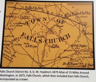
Virginia Village
1815 - 1861
Turnpikes and Tolls
Falls Church's location was close to the nation's capital and an essential stop along the route from Alexandria's port on the Potomac River to Leesburg and the western . . . — — Map (db m206633) HM
In 1861, Falls Church was a farm village located on the Alexandria-Leesburg Turnpike. On May 24, when Virginia's vote of secession became effective, Union troops crossed the Potomac and occupied Arlington Heights and Alexandria. On June 1, the 2nd . . . — — Map (db m2825) HM
The Story of Falls Church
The community located just 10 miles from the nation's capital and today known as Falls Church boasts a history rich in culture and diversity.
The People to 1700
Native Peoples and Their Land
For . . . — — Map (db m206631) HM
In August 1940, when this photograph was taken, passenger service on the Washington & Old Dominion was losing money and was being phased out. Passenger service stopped altogether in April 1941, but resumed two years later to support the national war . . . — — Map (db m55964) HM
Original Federal Boundary Stone
District of Columbia 1791
Protected by
Falls Church Chapter, NSDAR
Dedication 1916 Rededication 1989 — — Map (db m154760) HM
In memory of
1746 James Ireland 1806
Minister of the Gospel
Born in Edinburgh, Scotland and converted in Frederick County, Va.
Baptized and ordained at Sandy Creek, N.C. Imprisoned at Culpeper,
Va. for preaching the gospel organizer . . . — — Map (db m221644) HM
Before and during the Civil War she, her father, and uncle secretly ran a school where they taught reading and writing to free and enslaved Black people, although it was against the law. — — Map (db m231962) HM
Large log house named for its two huge chimneys. One datestone was inscribed 1699, the traditional date quoted for the community's founding. First recorded owner of site is Henry Gunnell (1773 22.75 acre grant). James Gordon, owner 1803-1836, had . . . — — Map (db m4192) HM
Greek Revival house believed built in 1845 by Wm. Harvey, who bought 66.5 acres (part of 1729 248-acre Trammell grant). Outbuildings added about 1857. Name derived from trees lining lane from Leesburg Turnpike. In 1870, Joseph S. Riley bought the . . . — — Map (db m555) HM
To all men and women who served their country during war and peace
[Dedication plaque on Flag Pole]
Flag Pole
Dedicated
on the
50th Anniversary of
The American Legion
Falls Church Posts
and Auxiliary Units . . . — — Map (db m125855) WM
In 1859, the church trustees bought this ½ acre (part of 1729 248-acre Trammell Grant) for $100. The 2-story clapboard over timber church served as a Union hospital and appears in Matthew Brady photos. Pastor John Read was shot by Mosby Troops . . . — — Map (db m17576) HM
After the Civil War demolition of Fairfax Chapel, the original part of this Gothic revival church was built by Southern sympathizers in 1869 on 2 acres donated by Wm. Y. Dulin (Part of 1742 208-acre Geo. Harrison Grant). Original chapel now forms . . . — — Map (db m2841) HM
She escaped slavery after the Battle of Vicksburg, walking from Mississippi to Washington, DC to reunite with family members. She eventually settled in Falls Church and owned a grocery store for many years. — — Map (db m186887) HM
Circuit riders brought Methodism to area in the late 1700s, holding meetings in homes. Fairfax Circuit initiated in 1776. Clapboard chapel built in 1779 and enlarged in 1798 on acre of land donated in 1818 by heirs of George Minor (a part of 1731 . . . — — Map (db m86184) HM
All persons who died serving in the line of duty during wars from 1775 to 1975
Revolutionary War
(Apr 1775 - Sep 1783)
War of 1812
(Jun 1812 - Jan 1815)
Mexican War
(May 1846 - Feb 1848)
Fairfax, Henry • . . . — — Map (db m206643) WM
Falls Curch early local civil rights pioneers organized to oppose the residential segregation ordinance. Their successful action influenced the state and the nation. — — Map (db m187005) HM
Although soldiers repeatedly overran and raided Cherry Hill Farm during the Civil War, this ca. 1845 farmhouse and the ca. 1856 barn behind it survived almost intact. William Blaisdell, of Massachusetts paid $4,000 for the 66-acre property in 1856. . . . — — Map (db m65407) HM
The Falls Church Community Center Gym was dedicated to E.B. Henderson (2002). The new middle school was named in honor of Mary Ellen Henderson (2005). — — Map (db m187032) HM
On this site stood the
Hangman's Tree
According to legend, an old oak used by Col. Mosby to hang Union
spies after the Battle of
The Peach Orchard during the
Civil War.
The tree was removed 1968.
Marker by the Falls Chruch . . . — — Map (db m37608) HM
She was the first free Black woman to own land in the center of town & was one of the founders of Galloway United Methodist Church. — — Map (db m186885) HM
This Colonial Revival bungalow (part of 1724 1,279-acre Pearson Grant) bought by Dr. Edwin B. Henderson in 1913. Henderson's ancestors include Powhattan Chief Mimetou. In 1904 he was first African-American certified to teach physical education; . . . — — Map (db m4202) HM
Wooden house built in 1854 on 10.1 acres bought by Robert Judson for $100 (part of 1729 248-acre Trammell Grant); named by second owner. During Civil War, used by CSA Gen. Longstreet in 1861; rafter marks identify later Union troops. Used as private . . . — — Map (db m191569) HM
In 1875, citizens of newly chartered town subscribed to build school, as classes were held in Baptist Church, in 1880 Joseph Birch donated land (a part of 1837 24.5-acre Kidwell grant) specifying it always must be used for education. In 1882 . . . — — Map (db m2856) HM
In 1899 she founded Virginia Training School for special needs children. Denied a seat on the 1908 School Board, due to her gender, she became a suffragist and was elected to the Town Council in 1921. — — Map (db m186888) HM
In Memory
of the Civil War Soldiers
who were buried here in this
Hallowed Ground
1861-1864
Edward Bowman, 21st NYVI
John Decker, 20th NYSM
Patrick Doyle, 20th NYSM
Horace Dougherty, 144th NYVI
Franklin E. Dunham, 20th NYSM . . . — — Map (db m77610) WM
This property at 472 N. Washington St. was part of a 1729 land grant from Lord Fairfax to John Trammell. Developed only after half the original 248 acres was sold in 1865 to Isaac Crossman, and the Fairfax and Georgetown Turnpike (now Lee Highway) . . . — — Map (db m125860) HM
In 1846 Presbyterians first met in private homes. In 1854, Dr. Simon J. Groot bought 11 acres for $179 (part of 1729 246-acre Trammell grant); Built two-story Groot Hall in 1856; Used for Sunday services, private school, community groups, town hall, . . . — — Map (db m2865) HM
July 21, 1911 was the 50th anniversary of the 1861 Confederate victory at Bull Run (Manassas), the first major land battle of the Civil War. For the occasion President William Howard Taft left the White House with a four-car caravan to drive the . . . — — Map (db m125857) HM
Site believed near intersection of two indian trails, later used by colonial horsemen and wagons. Tobacco growers improved the routes for delivering this valuable crop which was about ½ of all colonial exports. Draft animals pulled large . . . — — Map (db m4204) HM
Neo-colonial Brice residence, built in 1870 on 95-acre farm of John Green (Part of 1742 208-acre Harrison grant). Yale Rice, descendant of founder of Yale Univ., bought the property in 1890. Dr. and Mrs. Milton Eisenhower owned the house 1938-1943; . . . — — Map (db m2838) HM
Two-story building with verandahs stood on 56 acres bought in 1856 by Wm. Taylor (part of 1731 271-acre T. Harrison grant). Tavern faced Alexandria-Leesburg Pike west of Junction with Georgetown Road (Wilson Blvd.). Near here on June 24, 1861, . . . — — Map (db m2837) HM
Located on 2.1 acres of land purchased by Joseph E. Birch for $105 in 1849 (part of 1837 24.5-acre Kidwell grant). Original house was 1 1/2 story "I" house, raised to 2-stories in 1850s; 1873 addition doubled the size. Blacksmith/farmer Birch was on . . . — — Map (db m2858) HM
The Emerging City
1920 - 1950
From Horses to Highway
Prior to the 1920s, local roads were winding and narrow, cheap to build, and easy to maintain as they followed the land's contour to accommodate horses and wagons. . . . — — Map (db m206635) HM
This Georgian-style church designed and built in 1767-69 by James Wren, related to Sir Christopher, replacing the 1733 frame structure on 2-acre lot (part of 1729 248-acre Trammel grant). Washington and Mason were vestrymen. After the 1788 . . . — — Map (db m2870) HM
The Civil War dramatically affected this 1769 Anglican/Episcopal church that stands before you. The congregation disbanded as the war broke out, with some families fleeing the village. Confederate forces occupied the church in August and September . . . — — Map (db m72085) HM
The first church on this site was built in 1734 and was in Truro Parish. George Washington was elected a vestryman, October 3, 1763. In 1765 the church fell within the newly created Fairfax Parish, of which Washington was chosen a vestryman. The . . . — — Map (db m4189) HM
circa 1699
"Big Chimneys," is thought to be the first permanent structure built on land that is currently within the Falls Church City limits. The building was named for its two prominent brick chimneys. Placed in one of the chimneys was a . . . — — Map (db m191974) HM
"Big Chimneys," named for its two large brick chimneys, was probably the first permanent structure on the land that is today within the City of Falls Church. The home stood just east of this sign. The year "1699," inscibed on a chimney-stone, is . . . — — Map (db m192006) HM
This historic site is a testament to the long African American struggle to gain equality and civil rights. It also honors a moment of triumph for the human spirit.
African American life in Falls Church predates the 1700s. Enslaved . . . — — Map (db m151023) HM
This sculpture by Martha Jackson Jarvis, is a historical marker, and a symbol as well as a work of art.
The Zig Zag runs along the line that divides the Tinner Hill neighborhood into the City of Falls Church and Fairfax County portions. The . . . — — Map (db m187038) HM
Charles H. and Mary E. Tinner in 1890 paid $375 for 2.5 acres here (part of 1724 1,291-acre Pearson Grant), built a home on the crest and later provided lots from that property for their children. They farmed the land, quarried granite from the . . . — — Map (db m151022) HM
This historic site is a testament to the long African American struggle to gain equality and civil rights. It also honors a moment of triumph for the human spirit.
African American life in Falls Church predates the 1700s. Enslaved and free . . . — — Map (db m187039) HM
To the glory of
God
and in honor of
George Washington
who was a vestryman
in 1765 of
the old Falls Church
Built A.D. 1734
This tablet was placed by
the Falls Church Chapter,
Daughters of the
American Revolution
October . . . — — Map (db m77601) HM
Town was incorporated in 1875. A simple frame town hall was built here about 1880 on 1/4 acre (part of 1729 248-acre Trammell grant). Town Hall bell was rung for council meetings and fires. Later used only for police station. Torn down in 1953. Town . . . — — Map (db m2871) HM
(Text on Front of Marker): Alexandria-Leesburg Pike, chartered in 1813, was completed after 1838. An 1862 map shows a house and tollgate on four acres bought by John Williams in 1857 (Part of 1837 24.5-acre Kidwell grant). An older tollhouse . . . — — Map (db m125848) HM
(Front Side of Marker): The Duryee home and 11 acres were bought by Mattie Gundry in 1899 for $2,500 (part of 1773 22,75-acre Gunnell grant). On this site she opened the Virginia Training School for retarded children. At that time, it was the . . . — — Map (db m125844) HM
In 1912, from the station that stood nearby to your right, you could board a modern interuban passenger coach at 7:34 a.m. and arrive in Georgetown by 8:00 sharp. It was a new century and Washington, D.C., was on the move. The demand was heavy in . . . — — Map (db m2901) HM
Confederate Col. John Singleton Mosby's Partisan Rangers (43rd Battalion Virginia Cavalry) conducted raids on Falls Church through the summer and fall of 1864. On the night of October 17, a detachment of Mosby's command rode through the village down . . . — — Map (db m69552) HM
George Grant Crossman built this late Victorian vernacular farmhouse in 1892 for his bride Nellie Dodge. Three generations of the Crossman family operated a 60-acre dairy farm on the site until 1949. The Crossman family played a significant role in . . . — — Map (db m43540) HM
E.B. Henderson, whose pioneering work fostered African American participation in athletics early in the 20th century, lived in Falls Church from 1910 to 1965. After studying physical education at Harvard, he popularized basketball in his hometown of . . . — — Map (db m186877) HM
In Memory of
Henry Fairfax
An upright magistrate
A sincere Christian
Died in command of
The Fairfax Volunteers
at Saltillo Mexico 1847
But for his munificence
This church might still
have been a ruin.
Erected by the . . . — — Map (db m77662) HM WM
Arlington County. This county, formerly Alexandria County, was formed in 1847 from the part of the District of Columbia retroceded to Virginia. It was named Arlington County in 1920 for Arlington estate.
Fairfax County. Formed in 1742 . . . — — Map (db m210359) HM
In 1896, the Washington, Arlington & Falls Church Railway began running electric trolleys from Rosslyn to Falls Church on the present routes of Fairfax Drive and I-66. By 1907, the line linked downtown Washington to Ballston, Vienna, and the Town of . . . — — Map (db m64845) HM
Philadelphia Quaker abolitionist Emily Howland supported efforts in Falls Church to operate a school for black people before, during, and after the Civil War. — — Map (db m186972) HM
The Falls Church Town Council proposed as residential segregation ordinance requiring that all black people live in specific, confined areas of town. — — Map (db m187004) HM
The U.S. Supreme Court ruled, in Warley vs. Buchanan, that residential segregation districts are unconstitutional, nullifying the Falls Church ordinance. — — Map (db m187011) HM
Falls Church black activists included Claudis Brown, Audrey Williams, Joseph Tinner, Viola Hudson, Mary Ellen Henderson, E.B. Henderson, and Reverends Powell, Costner, and Colbert. — — Map (db m187030) HM
Early civil rights battles in the Town of Falls Church centered on basic rights, equality in education, city services, voting rights, and public transportation. — — Map (db m186990) HM
First president of the Falls Church branch of the N.A.A.C.P. and stonemason who quarried from the base of Tinner Hill, the billion year-old granite used in this monument. — — Map (db m151017) HM
In 1915, Falls Church ordered residential segregation. Many African-American homeowners would be forced to move. The Colored Citizens Protective League entered a lawsuit to prevent enforcement of the ordinance and joined the N.A.A.C.P. to become its . . . — — Map (db m151019) HM
An early rural branch of the National Association for the Advancement of Colored People (NAACP) was founded here on Tinner Hill. In 1915, the Town of Falls Church proposed an ordinance to segregate black and white residential sections. Local African . . . — — Map (db m55735) HM
On October 18, 1864 Reverend John B. Read, a lay preacher at the Falls Church Baptist Church, was executed in dense pine woods by the railroad bridge here at Piney Branch. Early that morning a contingent of Confederate Colonel John Singleton Mosby's . . . — — Map (db m24865) HM
This neighborhood along Railroad Avenue and the train tracks known as "Gravel Bank" was once home to several African-American families and businesses, and a vibrant part of the larger community. Lucinda Gaskins, an African-American woman, had . . . — — Map (db m144998) HM
At the beginning of the war, Union commanders were uncertain of Confederate intentions and military capabilities. On June 22, 1861, civilian balloonist Thaddeus S.C. Lowe inflated his racing balloon Enterprise at the Washington Gas Company . . . — — Map (db m41495) HM
Trolleys Come to Ballston
The Washington, Arlington & Falls Church Railway (WA&FC) established an interurban electric trolley along the present route of Fairfax Drive in 1896. The WA&FC's Fairfax trolley line ran through this site to Clarendon . . . — — Map (db m145148) HM
Carl was fond of angels and created them for several large fountains. These three angels are replicas of a few of his angels from fountains in the following U.S. cities: Falls Church, Philadelphia, and Kansas City. Each plays a different . . . — — Map (db m219266) HM
In August 1861, while U.S. forces were constructing the Arlington line three miles to the east, the Confederates established a fortified outpost on the high ground about 200 yards west of here to guard the bridge by which the Georgetown-Falls Church . . . — — Map (db m160141) HM
In August 1861, while U.S. forces were constructing the Arlington line three miles to the east, the Confederates established a fortified outpost on the high ground about 200 yards west of here, to guard the bridge by which the Georgetown - Falls . . . — — Map (db m68764) HM
For more than half a century from the mid-1800’s the intersection of Lee Highway and Glebe Road was known as Wunders Crossroads after the family whose farm lay just northeast. Dr. Henry S. Wunder and his son George O. Wunder were leading citizens of . . . — — Map (db m56255) HM
Here the Arlington Line constructed in August, 1861, crossed the Georgetown-Falls Church road. 100 yards to the northwest stood Fort Morton, a lunette with a perimeter of 250 yards and emplacements for 17 guns; 200 yards to the southeast stood Fort . . . — — Map (db m5161) HM
This intersection has been a focal point since about 1740, when two roads were developed, one from the future site to Alexandria to the mouth of Pimmit Run, the other from Awbury’s Ferry (at the site of Rosslyn) to the Falls Church. The first came . . . — — Map (db m55969) HM
By 1900 a well-defined village called Central Ballston had developed in the area bounded by the present Wilson Boulevard, Taylor Street, Washington Boulevard, and Pollard Street. More diffuse settlement extended westward to Lubber Run and southward . . . — — Map (db m72026) HM
The glebe was a 500-acre farm provided for the rector of Fairfax Parish, which included both Christ Church, Alexandria, and the Falls Church. The Glebe House, built in 1775, stood here. It burned in 1808 and was rebuilt in 1820, as a hunting lodge; . . . — — Map (db m208536) HM
Little Falls Road was originally a trail from the Indian villages at the head of Four Mile Run to the Potomac River fisheries just below the Little Falls. Later it was developed as a wagon road from the settlement at the Falls Church to Thomas Lee’s . . . — — Map (db m55811) HM
Named for Secretary of War Russell A. Alger, the camp was established in May 1898 on a 1,400-acre farm called Woodburn Manor. Some 23,000 men trained here for service in the Spanish-American War. The large military population greatly affected the . . . — — Map (db m4183) HM
Falls Church became a town. Frederick Foote, Jr. was elected Town constable and was the first black person on the Town Council (1880). Foote, George Thomas, and Eliza Henderson owned businesses patronized by black and white customers. — — Map (db m186983) HM
William Henderson, a black man, filed a lawsuit after he was illegally thrown from the Falls Church trolley. Local white Attorney Jacob DePutron's testimony helped win his lawsuit. — — Map (db m186993) HM
Black children from Falls Church were sent to segregated schools in Fairfax County which ended at 7th grade. Students traveled to Manassas, VA or Washington, DC for high school. — — Map (db m187020) HM
Falls Church Town became a City. Black residents started businesses: Blossom Inn, Annie's Dress Shop, Francis Jackson's Beauty Salon, Smitty's Barber Shop, Tinner Well Digging, Deskins Plumbing. — — Map (db m187018) HM
Emboldened by school desegregation in Arlington, Falls Church City Public Schools followed suit. The first children to integrrate were from the Costner, Lindsey, and Byrd families. — — Map (db m187026) HM
In the early 20th century, African Americans in Falls Church addressed inequities and discrimination through legal means. The black community prospered socially and in civic life. — — Map (db m187001) HM
Tinner Hill Heritage Trail features the history of African American families who lived in Falls Church since the 18th century. It honors their contributions to the City and civil rights legacy that influenced the state and the nation. — — Map (db m186945) HM
We, the members of Blue and Gray Post 225, of Falls Church, VA. dedicate this site to the brave men and women who made the supreme sacrifice in the wars to protect our freedom and our great nation, on this day and year of our Lord, November 11, 1997. — — Map (db m206638) WM
If you were a passenger on the Washington & Old Dominion Railway heading into Georgetown, you would first have to pass through Rosslyn, Virginia, a 15-minute train ride from here. The first Rosslyn Terminal dated from 1906, with the establishment . . . — — Map (db m24926) HM
137 entries matched your criteria. The first 100 are listed above. The final 37 ⊳
* Inflectional forms of words are their plurals, singulars, and possessives as well as gramatical tenses and similar variations.