On South Hall of Fame Drive, on the right when traveling south.
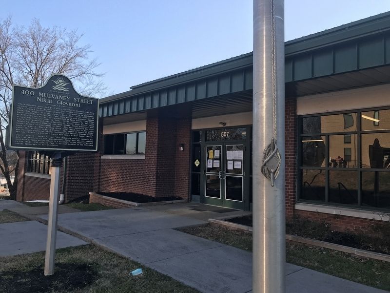
Internationally acclaimed poet and writer Nikki Giovanni was born to Knoxville College graduates Gus and Yolande Giovanni on June 7, 1943, at Old Knoxville General Hospital. She grew up in Cincinnati, Ohio, but Nikki and her sister, Gary Ann, spent . . . — — Map (db m167276) HM
Into this area rushed elements of four Confederate divisions on November 30, 1864 as they assaulted the Federal lines near the Carter cotton gin. Crossed largely by troops from Maj. Gen. Patrick Cleburne’s Division, the area was flooded by men . . . — — Map (db m137249) HM
On Big Mountain Pass (Utah Route 65), on the right when traveling east.
On 19 July 1847, scouts Orson Pratt and John Brown climbed the mountain and became the first Latter-day Saints to see the Salt Lake Valley. Due to illness, the pioneer camp had divided into three small companies. On 23 July, the last party, led by . . . — — Map (db m150080) HM
This is the Place Monument, dedicated July 24, 1947, commemorates the arrival of the Mormon pioneers into the valley of the Great Salt Lake one hundred years before, and also the role of others—Spanish Catholic fathers, trappers and fur traders, . . . — — Map (db m1525) HM
On Mount Independence Road, on the left when traveling south.
This walkway is a loop approximately 0.2 mile long with stairs and gentle slopes. It leads you past the remains of a blockhouse (near the parking area), provides a look at the Mount’s rock formations, and provides a vista of the lake south of the . . . — — Map (db m19536) HM
On Edmonds Lane, on the right when traveling west.
Mosby's Confederacy and First Manassas Campaign In the early morning hours of July 19, 1861, thousands of campfire lights burned in the camp of Col. Thomas J. Jackson's brigade which occupied the fields surrounding nearby Paris. Many thoughts . . . — — Map (db m4976) HM
On Shenandoah Street, on the right when traveling north.
(First Panel): Harpers Ferry National Historical Park is the story of... Industrial Development and the production of weapons at the Harpers Ferry armory. John Brown's Raid and his attempt to end slavery. The Civil War with Union and . . . — — Map (db m19008) HM
On E Congress Street at S Church Street, on the right when traveling east on E Congress Street.
The present church, the fourth on this site, was completed in 1851. Federal troops occupied it during the Civil War and severely damaged it. The churchyard contains the graves of many Washington family descents. They are buried near the eastern . . . — — Map (db m41675) HM
On Shenandoah Street at High Street on Shenandoah Street.
The Small Arsenal building that stood here from 1806—1861 was one of two warehouses for the nearby United States Armory. A Harpers Ferry visitor in 1821 described both buildings as "arsenals for the deposit of arms manufactured, consisting of . . . — — Map (db m99508) HM
On South Potomac Street, on the right when traveling east.
In an effort to increase the number of small arms for defense of the United States, George Washington established a Federal armory here in 1794. The rivers provided power for the machinery; surrounding mountains provided iron ore for gun barrels . . . — — Map (db m168267) HM
On Potomac Street, on the left when traveling west.
Only Marine killed in John Brown's Raid - October 18, 1859
Pvt Luke Quinn came from Ireland in 1835, and enlisted in the Marine Corps in 1855 in Brooklyn, NY. He was sent to sea duty, then transferred to Marine Barracks in Washington, D.C. He . . . — — Map (db m70780) HM WM
On Main Street at 9th Street, on the right when traveling west on Main Street.
Erected to honor the 5 men killed in the Battle of Osawatomie on August 30, 1856.
Dedicated August 30, 1877
——————————
[Monument inscription reads]
In commemoration of those who . . . — — Map (db m69304) HM
On Potomac Street, 0.1 miles north of Shenandoah Street, on the right when traveling north.
Along this path lie the remains of revolutions. Six acres of the U.S. Armory at Harpers Ferry have been reduced to rubble. Buildings that buzzed with activity and innovation now lie covered with dirt. Train tracks that pushed to the edge of a new . . . — — Map (db m20475) HM
On Fair Avenue east of Arkansas Highway 59, on the right when traveling east.
Founded in 1889 has been entered into the National Registry of Historical Places by the United States Department of the Interior on 7-8-99. — — Map (db m224982) HM
On Manada Road, on the right when traveling north.
For centuries the Cajon Pass has been an important thoroughfare for travelers and traders between the Mojave Desert and Southern California. Following the route of the Old Spanish Trail, most travelers transited the pass on its east side. This . . . — — Map (db m80751) HM
On Monument Street, on the left when traveling west.
British Officer - “Who commands this fort ” Colonel Ledyard – “I did sir, but you do now ” Killed – Lieut. Col. William Ledyard, Commanding Capt. Elijah Avery • Capt. Elisha Avery • Lieut. . . . — — Map (db m19584) HM
On 1st Street at East Park Street, on the left when traveling north on 1st Street.
The First Congregational Church, built in 1855-56, was popularly known as the “Goose Pond” Church, because the site was once a water-filled area, home to flocks of wild geese and ducks. The church became a meeting center for numerous . . . — — Map (db m31118) HM
The bloodiest single incident in the Kansas-Missouri border struggles, 1854-1861, occurred May 19, 1858, when about 30 Proslavery Missourians seized 11 Kansas Free-State men near Trading Post and marched them to a ravine 225 yards northwest of this . . . — — Map (db m39861) HM
On 27th Street at Sewell Avenue, on the left when traveling north on 27th Street.
Western University had its beginning in the Quindaro Freedman's School founded in the 1860s by the Reverend Eben Blachley, a Presbyterian Minister.
The Freedmen's School was intended to provide education for the children of escaped slaves and . . . — — Map (db m69459) HM
On Mooreland Avenue east of Chestnut Street, on the right when traveling east. Reported permanently removed.
Early Gun Shop Site
Here Benjamin Mills made some of finest rifles in US, ca. 1830-50. His muzzle loaders famous for dual trigger system. Used by Kit Carson and Dr. Christopher Graham, conceded to be best rifle shot in world at that time. . . . — — Map (db m46252) HM
On Mooreland Avenue east of Chestnut Street, on the right when traveling east.
Early Gun Shop Site
Here Benjamin Mills made some of finest rifles in US, ca. 1844-1863. His muzzle loaders were famous for their superb accuracy at a time when craftsmanship made all the difference. Used by Dr. Christopher Graham, conceded . . . — — Map (db m191655) HM
On South Market Street at All Saints Street on South Market Street.
At this intersection, President Abraham Lincoln spoke from a railroad car platform to Frederick residents assembled in the street on October 4, 1862. He had just returned from viewing the battlefields of South Mountain and Antietam and had called on . . . — — Map (db m60166) HM
Near Mount Calvert Road, 0.4 miles east of McClure Road.
The house you see before you was the home of several plantation owners. John Brown built the Federal-style house in the 1780s. Later, John Brooks and Samuel Berry lived here with their families. Each owner left his imprint by making changes to the . . . — — Map (db m127221) HM
On South Washington Avenue (State Highway 24) near Dennison Street, on the right when traveling south.
In Memory Of Our Sons Who Made The Supreme Sacrifice In World War II, 1941 - 1945
Lavern H. Becker · Jack W. Dalgleish · Richard C. Quayle
John Brown · Frank Kreuger Jr. · Charles Scriver
Ronald Cheney · Elon R. Lintz · Donald Seal
Truman . . . — — Map (db m190380) WM
On Main Street (New York State Route 146) at Gun Club Road, on the right when traveling west on Main Street.
Welcome to Altamont
The Village of Altamont and its immediate surroundings were once part of a tract of land deeded in 1630 by the Dutch West India Company to Killian Van Rensselaer (c. 1586-1643),a wealthy 17th century Dutch . . . — — Map (db m132693) HM
On Bell Avenue, 0.1 miles north of Main Street (New York State Route 104A).
A Commerce Center. Though camps, pleasure boats, and the sandy beaches of Fair Haven State Park dominate the bay and lake shore today, in 1910 Little Sodus Bay was the second busiest port on the southern shore of Lake Ontario. Trains . . . — — Map (db m79751) HM
On North Main Street (Ohio Route 91) just south of Aurora Street, on the right when traveling north.
Hudson had a long tradition of being an anti-slavery town. By 1826, records show that the town's founder, David Hudson, was hiding runaway slaves at his home. Early settler Owen Brown and his family helped organize the Underground Railroad in . . . — — Map (db m189296) HM
Near Oregon Route 62, 0.1 miles west of County Route 623.
Fort Klamath
These 58 soldiers and associates were buried in this cemetery, including 22 casualties of the Modoc War. In 1890, after the fort was abandoned, the remains were exhumed and laid to rest at the Presidio in San Francisco.
Pvt. . . . — — Map (db m91782) HM WM
On West Dunlap Street, 0.1 miles west of South French Street, on the right when traveling west.
Franklin Academy
Organized in 1825, was the most widely-known of the four schools that occupied this site. Henry Connelly was its first principal. J. Marion Sims who later achieved world fame as a surgeon was one of its pupils. The building of . . . — — Map (db m23836) HM
On Marshall Drive near Richmond Highway. Reported permanently removed.
Marines have been fighting and dying in defense of freedom since the United States Marine Corps inception in November, 1775. The names of principal campaigns engraved on the memorial are a testament to the sacrifices Marines have made in their . . . — — Map (db m129448) HM
On South Main Street (Business U.S. 11) at Franklin Street, on the left when traveling north on South Main Street.
This was the home of Edward T.H. Warren, a Harrisonburg attorney. As a lieutenant in the Valley Guards, a Rockingham County militia company, Warren attended the trial and execution of John Brown in Charles Town (in present-day West Virginia) in . . . — — Map (db m158113) HM
On South Main Street (Business U.S. 11), on the left when traveling north. Reported permanently removed.
This was the home of Edward T.H. Warren, a Harrisonburg attorney. As a lieutenant in the Valley Guards, a Rockingham County militia company, Warren attended the trial and execution of John Brown in Charles Town (in present-day West Virginia) in . . . — — Map (db m41497) HM
On Ararat Highway (County Route 773), on the right when traveling south.
Laurel Hill, the 1,500-acre farm of Archibald and Elizabeth Letcher Pannill Stuart, was the birthplace of their seventh child, James Ewell Brown Stuart, at 11 a.m. on February 6, 1833. The house burned to the ground during the winter of 1847-48. . . . — — Map (db m54713) HM
Near Jefferson Davis Highway (U.S. 1) 0.1 miles south of Joplin Road (Virginia Route 619), on the left when traveling north.
Marine Corps history is replete with illustrious battle names that due to the passage of time have grown dim to historical memory. Thus it is important for Marines of today to remember what their predecessors accomplished in many a bygone "clime . . . — — Map (db m215208) HM
On Lee Highway (U.S. 211) at Richmond Road (Virginia Route 729), on the right when traveling east on Lee Highway. Reported permanently removed.
The three brick cabins in the field before you are tangible connections to the enslaved people of Rappahannock County before and during the Civil War. Many slaves escaped to Union lines here and elsewhere, and some former bondsmen served in the U.S. . . . — — Map (db m49451) HM
Near Hospital Street at North 4th Street, on the left when traveling west.
Nearby are buried at least 661 United States soldiers who died between July 1861 and June 1863 while prisoners of war in this city. Many died at Confederate General Hospital Number 1 adjacent to Shockoe Hill Cemetery which took in Union wounded . . . — — Map (db m79708) HM WM
Near Whitman Avenue at West Washington Street (Alternate U.S. 340), on the left when traveling north.
"…We enter the barren waste of Bolivar Heights…a windswept deserted moorland…except its populous graveyard." James E. Taylor, war correspondent Frank Leslie's Illustrated Newspaper August 10, 1864
On U.S. 340, 0.1 miles west of Union Street, on the right when traveling west.
United States Marine
Killed 18 October 1859
During the capture of John Brown
Flagpole and gravesite rededicated by
Marine Corps League Detachment 1143
13 0ctober 2012 — — Map (db m104281) HM WM
On Potomac Street, on the right when traveling west.
Thousands of enslaved people fled to the Union lines at Harpers Ferry during the Civil War. Some of them found shelter in the "contraband camp" located near here in the shadow of John Brown's Fort. Their freedom and safety were always in . . . — — Map (db m20491) HM
On 2nd Street at Pump Street, on the right when traveling west on 2nd Street.
This is the home of John Echols, lawyer and general in the Confederate army. A graduate of Washington College in Lexington, Virginia, he also attended the Virginia Military Institute and Harvard University.
After John Brown’s failed Harpers . . . — — Map (db m59264) HM
Near South Levee Road east of Prison Hill Road, on the right when traveling south.
In memory of
the inmates, who lost their life
while serving their sentence, at the
Arizona Territorial Prison at Yuma
Aldrete, Simon • Alejandra • Alveres, Thomas • Armbula, Tomas • Arnett, William • Arvizu, Gregorio • Baca, Antonio • . . . — — Map (db m51636) HM
On Cajon Boulevard, on the right when traveling east.
Cajon Pass, separating the San Bernardino and San Gabriel ranges, has long been an important natural gateway. It is traversed by Indian trails, emigrant routes, railroads, and a superhighway. Early in the nineteenth century it became the southern . . . — — Map (db m119252) HM
On Mendocino Avenue at Benton Street, on the left when traveling north on Mendocino Avenue. Reported missing.
The 1905 Comstock House is undergoing a restoration. This house was designed by local architect Brainerd Jones, who also created most of the buildings in Petaluma's historic core as well as the nearby Belvedere.
Jones included may whimsical . . . — — Map (db m102519) HM
Near Hopmeadow Street (Connecticut Route 10) at Station Street, on the left when traveling north.
1775 – 1783
We, the people of the Town of Simsbury, do hereby recognize the many hardships and countless sacrifices made by those brave American Revolutionary Soldiers; especially those from Simsbury, who died for our freedom from England. We . . . — — Map (db m88058) WM
On Fitchville Road (Route 608) at River Road, on the right when traveling east on Fitchville Road.
This memorial will forever honor the men and women who bravely
served during the Civil War era
The actions of those who answered the call to duty will be remembered for their
sacrifice in defense of freedom and liberty
Jared A. Abell · . . . — — Map (db m101737) WM
On North Collins Street at East Gilchrist Street, on the left when traveling north on North Collins Street. Reported permanently removed.
(Front face)1863 - 1865 Erected by Plant City Chapter #1931 United Daughters of the Confederacy November 17, 2007
By 1863 the Confederate Army was suffering severe food shortages. Capt. John T. Lesley was commissioned to recruit from . . . — — Map (db m46292) HM
"But remember this, I am a girl, but I can fire a pistol and if ever the time comes I will send some of you to the place where there is [sic] 'weeping and knashing of teeth'...."
Gene Campbell, in a letter to James Montgomery, . . . — — Map (db m54075) HM
On Mount Calvert Road, 0.4 miles east of McClure Road, on the right.
A Tobacco-based Ecomony
For more than 200 years, slave-based tobacco plantations dominated the economy of Prince George's County. After the county seat moved from Mount Calvert to Upper Marlboro in 1721, Mount Calvert was the center of a large . . . — — Map (db m187414) HM
In Memory of
Osborne Perry Anderson
July 17, 1830 December 11, 1872
This dedicated and brave Christian traveled from Chatham, Canada to Harper's Ferry,
West Virginia, to fight beside John Brown in his quest to abolish slavery. He . . . — — Map (db m202682) HM WM
Early History
Williamsport was along the heavily traveled "Indian Trail" and occupied by the Iroquois, Delaware, Catawba, Algonquin and Massawomenkes tribes. The settlement was known as Conococheague, an Indian name meaning either "a long . . . — — Map (db m95939) HM
In the spring of 1636, a small band of early settlers from Roxbury, Massachusetts ventured up the Connecticut River to settle in Springfield, then known by its Indian name of Agawam. Together they executed an agreement which in part reads: "Wee . . . — — Map (db m158500) HM
On West Chicago Street (U.S. 12) at Marshall Street (Old U.S. 27), on the right when traveling west on West Chicago Street.
Memorial
To honor those valiant men and women of World War II who gave their lives for God and Country
Paul Keller • Richard Symons • Donald Perry • Rollin Johnson • Marion Nutt • Donald Russell • Sidney Palmateer • Harold Van Patten • . . . — — Map (db m66769) WM
Near East Front Street at Navarre Street, on the left when traveling east.
Norman Jonathan Hall was born March 4, 1837 in Geneva, New York. His family moved to Monroe County when Norman was 12 years old and settled on a 333 acre farm along the River Raisin in east Raisinville. He was appointed to West Point in July 1854, . . . — — Map (db m201536) HM
On Wolfe Road, 0.3 miles north of Wolfe Circle, on the right when traveling north.
The Church of Jesus Christ of Latter-Day Saints was organized on April 6, 1830. Missionaries first arrived in northeastern Mississippi in 1839. Here at Mormon Springs many converts to the church were baptized. Using stones to dam the stream, they . . . — — Map (db m244673) HM
On Frederick Douglass Boulevard at West 122nd Street on Frederick Douglass Boulevard.
This larger-than-life bronze sculpture depicts abolitionist organizer and Underground Railroad leader Harriet Tubman (c. 1822-1913), and stands at the crossroads of St. Nicholas Avenue, West 122nd Street and Frederick Douglass Boulevard in Harlem. . . . — — Map (db m105284) HM
Built by John Brown & Co., Clydebank, Glasgow. M.V. Liverpool-New York, 30 May 1914. The last four-funneled Atlantic liner, considered by many to be one of the most beautiful ships ever built. Commissioned as an armed merchant cruiser, August 1914, . . . — — Map (db m169813) HM
Near West Street west of East 47th Street, on the right when traveling south.
Built by John Brown & Co., Clydesbank, Glasgow; the largest passenger ship in the world at the time. Left the Clyde for New York under wartime conditions, 27 February 1940. Served as troopship 1940-1946. Refitted for passenger service 1946; F.V. . . . — — Map (db m169145) HM
Laid down 1930 by John Brown & Co. Work suspended late 1931 due to economic depression; resumed April 1934. M.V. Southampton-New York, 27 May 1936. Became undisputed holder of the “Blue Riband” in August 1938 with crossings of speeds of 30.99 knots . . . — — Map (db m169525) HM
On East Jefferson Street at East Onondaga Street, on the left when traveling east on East Jefferson Street.
"The president of the railroad… humanely provided me with free passes for the fugitives on the road to Canada and freedom."
— Charles Merrick, Reminiscences of the Jerry Rescue, 1893
The Wesleyan Methodist Church was a . . . — — Map (db m138794) HM
A Tribute to Those Who Served
John Adams • Thomas Aery • David Agner • Roscoe Anderson • Richard Artz • Carl Ashford • Harold Atkinson • Clarence Bain • Philip Barbee • Lester Bennett • Ray Bilbo • John Binkley • William Blair • Chester . . . — — Map (db m51306) HM
On Walnut Street at North Front Street, on the right when traveling west on Walnut Street. Reported permanently removed.
By late June 1863, the Confederate Army had invaded Pennsylvania. After capturing York, the Rebels planned to take the state capital, Harrisburg, and possibly Philadelphia. To get there, they would need to cross the Susquehanna River at . . . — — Map (db m170239) HM
On North George Street (Business Interstate 83) at East 3rd Avenue, on the right when traveling south on North George Street.
12. Michael P. Small (1831-1892): Uphill in the distance to your right is the grave of Michael Small. Small was born in York and was a son of John Small. A graduate of West Point class of 1855, he participated in the Harper's Ferry . . . — — Map (db m205742) HM
On West Main Street at North Berkshire Avenue, on the right when traveling west on West Main Street.
Site of Crosbyton's first bank. In 1909, First State Bank (soon named First National) opened in a new two-story concrete block and stone building, erected by C. B. Livestock Company. For bank, office use.
In 1917, Citizens National Bank (est. . . . — — Map (db m105215) HM
On North Main Street, 1.3 miles north of Utah Route 9, on the right when traveling north.
The confluence of Ash and LaVerkin Creeks with the Virgin River is important in the history of this region. Footsteps long forgotten have passed through this region. Some have been remembered but most have faded with time. Roaming bands of Indians, . . . — — Map (db m59447) HM
On Center Street, 0.6 miles west of Utah Route 9, in the median.
The confluence of Ash and LaVerkin Creeks with the Virgin River is important in the history of this region. Footsteps long forgotten have passed through this region. Some have been remembered but most have faded with time. Roaming bands of Indians, . . . — — Map (db m59449) HM
On South Chestnut Street at West Lee Street, on the left when traveling south on South Chestnut Street.
The gate to your right opens to Warrenton Cemetery, the final resting place of 986 Confederate soldiers, of every Southern state, about 650 casualties of the Civil War. Many wounded Confederates were evacuated to Warrenton and vicinity after the . . . — — Map (db m151310) HM
Near Gordon W Shelton Boulevard, 0.7 miles north of Willow Lane, on the right when traveling west.
History is a heroic selective interpretation of the past wherein ordinary persons become icons and antagonists are demonized. Such is the sense of many anti-slavery proponents like Nat Turner, John Brown, Denmark Vesey and Charles Sumner.
What . . . — — Map (db m176106) HM
On Washington Street (Business U.S. 340) east of Boundary Street, on the left when traveling east.
The Reverend Doctor Josiah P. Smeltzer laid the cornerstone of St. John's Lutheran Church on April 30, 1850. The building was completed two years later and dedicated on August 1, 1852. Little more than seven years had passed when, at dawn on . . . — — Map (db m70794) HM
On S. Duke Street, on the right when traveling south.
Side A Confederate Soldiers in Elmwood Cemetery Over 114 Confederate soldiers who were killed at the Battle of Sharpsburg (Antietam) September 17, 1862, or later died of wounds in Shepherdstown, were buried here. They were from the . . . — — Map (db m154058) HM
On Kate Kegwin Street, 0.1 kilometers east of Mkade Kegwin Miikan, on the right when traveling east.
The first of the “Imperial Tower” lighthouses to be completed and the first official lighthouse on Lake Huron's Georgian Bay. Constructed in 1857, it was one of 6 similar lighthouses commissioned by the province of Canada West. These lights were . . . — — Map (db m196039) HM
On 14th Street Northwest at Pennsylvania Avenue Northwest, on the right when traveling south on 14th Street Northwest.
"This hotel, in fact, may be much more justly called the center of Washington and the Union than either the Capitol, the White House, or the State Department...."
Nathaniel Hawthorne, Civil War reporter for The Atlantic . . . — — Map (db m211824) HM
On East Main Street west of South Monticello Street (a.k.a.: US 35), on the left when traveling west.
U. S. Civil War
1861 - - 1865
From 1861 - 1865, Pulaski County men served the Union in the Civil War. Serving primarily in Co. B, 87th and Co. H, 46th Infantry Regiments of Indiana Volunteers, these soldiers valiantly gave their . . . — — Map (db m42691) WM
Near Interstate 80 at milepost 208,, 3.6 miles west of County Highway V52, on the right when traveling west.
Josiah Bushnell Grinnell, a native of Vermont, was the person to whom Horace Greeley gave his famous advice “Go West, young man, go West.” Grinnell took that advice and in 1854 founded the city that now bears his name. A leader in state government, . . . — — Map (db m224360) HM
On Wapping Street at Washington Street on Wapping Street.
Homes of
Thomas S. Todd • John M. Harlan
George M. Bibb • John J. Crittenden
John Brown • James Brown
Thomas Metcalfe • Robert P. Letcher
George C. Vest • Benjamin G. Brown
James Harlan • Charles S. Morehead
Thomas S. Crittenden . . . — — Map (db m97496) HM
Near Bucktown Road at Greenbriar Road. Reported missing.
Dorchester County occupies a central place in the story of the Underground Railroad, the secret network of "stations" and "conductors" that sheltered and shepherded hundreds of enslave African Americans to freedom in the mid-1800s. The famed . . . — — Map (db m126550) HM
Near Mount Calvert Road, 0.4 miles east of McClure Road.
A Confluence of Three Cultures
Mount Calvert Historical and Archaeological Park overlooks the confluence of the Patuxent River and the Western Branch. A series of interpretive panels, describes the archaeological and historical resources from . . . — — Map (db m68298) HM
On Mount Calvert Road, 0.2 miles east of McClure Road, on the right.
A Confluence of Three Cultures
Mount Calvert Historical and Archaeological Park overlooks the confluence of the Patuxent River and the Western Branch. A series of interpretive panels describes the archaeological and historical resources from . . . — — Map (db m187415) HM
Near Defiance Street, 1.3 miles east of The Portage when traveling east.
In 1758 British officers and engineers examined Ticonderoga's defenses from low on Mount Defiance prior to the July 8th Battle of Carillon. During the battle, Mohawk, Delaware, and Choctaw warriors allied to the British army, positioned themselves . . . — — Map (db m193735) HM
Near New York State Route 86 at Lakeview Terrace Lane, on the right when traveling west.
One of the first settlers, Reuben Sanford was an instrumental force in the development of Wilmington, building mills, an iron forge, stores and distilleries.
Even when travel to the Adirondacks involved many challenging miles by train and . . . — — Map (db m147455) HM
On Dick Street south of Halliday Street, on the right when traveling north.
Duncan McLeran constructed this two-story Federal-style dwelling in 1797. In 1820, the property was sold and remodeled to accommodate the Bank of the United States, the first federal bank in North Carolina. The house is named for John Sanford, a . . . — — Map (db m70374) HM WM
On Pine Street (Ohio Route 160), on the right when traveling north.
Side A:
The African Methodist Episcopal Church was organized in 1818 as the Bethel Church. In 1868 its present name, John Gee, was adopted when the church was erected and rededicated at this present site on land donated by Gee. Founders of . . . — — Map (db m30582) HM
On North Main Street (U.S. 11) north of Lincoln Way East (U.S. 30), on the left when traveling south.
The Greatest Sacrifice
Chambersburg
The price of war is devastation. Franklin County paid the price when its county seat, Chambersburg, was burned to the ground in 1864. Invaded in 1862, 1863, and 1864 by Confederate forces, Franklin . . . — — Map (db m201757) HM
On East Market Street (Pennsylvania Route 462) just east of South George Street (Business Interstate 83), on the right when traveling east.
Faced with the impossible task of defending an essentially unarmed city against the six thousand battle hardened troops of General Jubal Early, the citizens of York met with the Confederates and negotiated surrender, in an act which was . . . — — Map (db m181437) HM
On Thames Street south of Franklin Street, on the right when traveling south.
After the Civil war, Bristol's economy shifted to the production of rubber goods. In 1865, August O. Bourn established the National Rubber Company on Wood Street and began manufacturing rubber using vulcanizing technology, which had been recently . . . — — Map (db m222849) HM
On Mechanic Street west of 23rd Street, on the left when traveling west.
One of the earliest commercial blocks in Galveston, this row of three three-story brick buildings was constructed for John Berlocher by builder John Brown. The easternmost building, 2309 Mechanic, was erected in 1858. The westernmost, 2315 Mechanic, . . . — — Map (db m127493) HM
On Humpherys Drive, on the right when traveling north.
In Memory Of
The Men of the Lexington Militia
Killed In Action • 19 April 1775
During the First Battle of the American Revolution
John Brown Robert Munroe
Samuel Hadley Isaac Muzzy
Caleb Harrington Jonas Parker . . . — — Map (db m62373) WM
Near West Main Street (Business U.S. 211) at Carillon Drive (Business U.S. 211), on the right when traveling west.
Born into slavery on a farm just east of Luray around 1813, Bethany Veney lived a remarkable life of faith, resilience, strength, and forgiveness. Her 1889 autobiography, Aunt Betty’s Story: The Narrative of Bethany Veney, a Slave Woman, . . . — — Map (db m227621) HM
On Hammonds Mill Road (West Virginia Route 901) east of Harlan Springs Road (County Route 1), on the right when traveling west.
Dr. Allen C. Hammond constructed this Greek Revival-style house about 1838. During the Civil War, both sides used it periodically for a headquarters or a hospital. The war ruined Hammond, a strong Southern sympathizer.
In October 1859, . . . — — Map (db m154839) HM
On Washington Street, on the right when traveling west.
As you explore Jefferson County’s Civil War sites, you will learn about some of the notable exploits on the native soil of Thomas J. “Stonewall” Jackson, one of the war's most famous figures. Jackson was born in Clarksburg, Virginia (now West . . . — — Map (db m155096) HM
Near Fillmore Street at Storer College Place, on the right when traveling east.
We claim for ourselves every single right that belongs to a freeborn American, political, civil and social, and until we get these rights we will never cease to protest and assail the ears of America. The battle we wage is not for . . . — — Map (db m173631) HM
On Sandy Row at Hope Street, on the right when traveling north on Sandy Row.
[Historic photo captions read]
1. Mr R. J. Moss, Headmaster of Mabel St. School from 1886-1921
2. Saturday night dancing at the Orange Hall in Sandy Row
3. John Brown pictured outside his popular 'Ribbon Shop'
4. A friendly chat on the . . . — — Map (db m134085) HM
On North Pikes Peak Avenue (Colorado Route 67) at East 4th Street, on the right when traveling north on North Pikes Peak Avenue.
Travel the route of these explorers and read Lt. Pike's own words from his journal
U.S. Army Expedition to explore the United States' new southwest boundary with New Spain
The men
Lt. Zebulon M. Pike • Dr. John H. Robinson . . . — — Map (db m153110) HM
Near East 5th Street at Monument Avenue, on the left when traveling east.
Considered by many to be the first casualty of the Civil War, abolitionist editor and Presbyterian minister Rev. Elijah P. Lovejoy was killed defending the freedom of the press.
Editor of the St. Louis Observer, Lovejoy wrote . . . — — Map (db m133295) HM
On South 4th Street (State Highway 25) at L Street, on the right when traveling south on South 4th Street.
Those Who Made The Supreme Sacrifice In Wichita County
* Denotes killed in action
WW II
Fitzgerald, Wayne • Mays, Richard D. • Naab, John V.
Korean Veterans
Appl, Keith A. • Baker, Don • Baker, Joseph • Berning, Edmund • . . . — — Map (db m200723) WM