Near Old Oregon Trail, on the right when traveling west. Reported permanently removed.
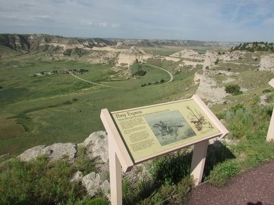
Go back in time to 1860 or 1861 and picture the traffic on the Oregon Trail – the freight wagons and stagecoaches, and the emigrants, soldiers, and Indians. But most colorful, perhaps, was the Pony Express rider streaking through Scotts . . . — — Map (db m156142) HM
Near Old Oregon Trail Road, on the right when traveling west.
The Pony Express passed here 1860-1861. Scott’s Bluff station was located 2 1/2 miles northwest of Mitchell pass, near the site of the later Fort Mitchell. There were others stations at Courthouse Rock, Chimney Rock, Ficklin’s Springs, and Horse . . . — — Map (db m79425) HM
On State Highway 92 at Hunt Dairy Road, on the right when traveling east on State Highway 92.
Text is found on both sides of this marker
Dedicated October 5, 2013
Scott’s Bluff
Original Station
Apr. 3, 1860 - Nov. 20. 1861
by
James Stretesky
Joseph L. Schroeder
Panhandle Monument
Gordy & Linda . . . — — Map (db m79437) HM
On 9th Street just west of C Street, on the right when traveling west.
During the nineteenth century the United States underwent a dramatic westward expansion, but perhaps no single event stimulated this mass migration more than the 1848 discovery of gold at Sutter’s Mill in California. Hundreds of thousands of . . . — — Map (db m206659) HM
On North Carson Street (Lincoln Highway) (Business U.S. 395) north of West Robinson Street, on the left when traveling north.
”Pony” Bob Haslam, considered to be the greatest of all Pony Express riders, rode for the Express from the beginning to the end. His route was through Carson City, one of the relay stations.
Erected by the Nevada Pony Express Centennial . . . — — Map (db m128553) HM
On South Carson Street (Business U.S. 395), on the right when traveling south.
[Front of Marker:]
Dedicated April 12, 1996
Carson City
Original Station
Apr. 3, 1860 - Nov. 20, 1861
by
Byron L. & Peggy Clark & Family
Bob & Tina McFadden
Mae & Jim Thorpe
The Bike Smith
Betty Young & Erica . . . — — Map (db m23038) HM
On North Carson Street (Lincoln Highway) (Business U.S. 395) north of West Robinson Street, on the left when traveling north.
Honour to the Nevada men who were riders in the July 19 to 28, 1960 Centennial Reenactment of the Pony Express
Monument Erected by the
Pony Express Club of Nevada
National Pony Express Centennial Association
Dwight D. . . . — — Map (db m128554) HM
On North Carson Street at East Telegraph Street, on the right when traveling north on North Carson Street.
Carson City, Nevada, was one of the stations along the historic but hazardous 1966 mile Pony Express route between Sacramento Cal. and St. Joseph, Mo.
This monument is dedicated July 20, 1960 in memory of the Pony Express, during the epic . . . — — Map (db m101828) HM
On U.S. 50, 23 miles north of Nevada Route 722, on the right when traveling north.
Replacement Marker
Abundant grass and brush found near springs and intermittent streams in Edwards Creek Valley were important ecological areas for Native Americans. Shoshone Indians wandered seasonally to gather wild seeds and small . . . — — Map (db m67146) HM
One hundred and fifty years ago, the Pony Express was founded by W. H. Russell, Alexander Majors and William B. Waddell, operators of the Overland Stage Line of Leavenworth, Kansas. During a visit to Washington, Mr. Russell was urged by California . . . — — Map (db m69681) HM
On U.S. 50, 11 miles north of Nevada Route 722, on the left when traveling north.
Replacement Marker
Rock Creek was an important stagecoach stop on the Overland Mail Stage Company's historic line along the Simpson route between Salt Lake City and Genoa, Nevada, which was operated by John Butterfield (1861-1866) and . . . — — Map (db m67144) HM
Two small rooms at the southwest end of the station were originally one large room and shared a common wood floor. The wall which now separates the two rooms was built on top of the floor some time later. The center room was probably used for . . . — — Map (db m127117) HM
Near Lincoln Avenue (U.S. 50) 25 miles east of Maine Street (U.S. 95), on the left when traveling east.
"The Mail Must Go Through"
From April 3, 1860 to November 21, 1861, mail was delivered by the Pony Express between St. Joseph, Missouri and Sacramento, California. It was a relay system between 190 stations along the route. A fresh horse was . . . — — Map (db m142572) HM
Near U.S. 50, 11 miles north of Nevada Route 722, on the right when traveling north.
Competing with time, distance, harsh climate, and hostile Indians, the Pony Express carried important communications from the East and the West across 2,000 miles in only 10 days.
The "Pony," as it was called, is an outstanding . . . — — Map (db m67142) HM
Near Lincoln Avenue (U.S. 50) 25 miles east of Maine Street (U.S. 95), on the left when traveling east.
Sand Springs Deserved its Name The rocks you see in front of you were once Sand Springs Pony Express Station. The Pony Express ended in November 1861, but this Station was used as a stopover for freight wagons until the late 1800s. It laid . . . — — Map (db m142573) HM
Near Nevada Route 361 south of Lincoln Highway (U.S. 50), on the right when traveling south.
Middlegate was named in 1850 by James Simson as he mapped the route for the Overland Stage Company. In his journal he writes that he thought the cuts in the mountains looked like 'gates' so he named each cut Westgate, Middlegate, and Eastgate to . . . — — Map (db m89452) HM
On Foothill Road (Nevada Route 206) at Old Kingsbury Grade Road, on the right when traveling south on Foothill Road.
Dagget Pass Trail, named for C.D. Dagget, who acquired land at its foot in 1854, was earlier called Georgetown Trail. Replaced in 1860 by the wagon road built by Kingsbury and McDonald, for which they received a Territorial Franchise in 1861, it . . . — — Map (db m21892) HM
On Jacks Valley Road/Main Street (Nevada Route 206), on the right when traveling south.
[Front of Marker:]
Genoa
Original Home Station
April 3, 1860 – Aug. 30, 1860
Relay Station
Sep. 1, 1860 – Nov. 20, 1861
By
Town of Genoa
Genoa Volunteer Fire Department
Carson Valley Historical Society . . . — — Map (db m20663) HM
On Main Street at Genoa Lane (Nevada Route 206), on the right when traveling north on Main Street.
Panel One:
Utah Territory
The area now making up the state of Nevada was acquired by the United States after the Mexican-American War. This newly acquired land was generally labeled as unorganized territory until 1850. The State of . . . — — Map (db m227650) HM
On Jacks Valley Road/Main Street (Nevada Route 206), on the right when traveling south.
These plaques are near the site
of the original Pony Express Station.
The Pony Express passed through
Genoa, the oldest city in Nevada, until
the completion of the telegraph.
Erected by the Nevada Pony
Express Centennial Committee. . . . — — Map (db m20711) HM
On US Highway 50 (U.S. 50) near Lake Parkway, on the left when traveling east.
(back) The Pony Express Started on April 3, 1860. The original route from Johnson Pass (Echo Summit) to Genoa went through Hope Valley to Woodfords Station.
On May 14, 1860 the new toll road over Daggett Pass opened to foot and horse . . . — — Map (db m432) HM
On Lake Tahoe Boulevard (U.S. 50), on the right when traveling east.
In commemoration of The Pony Express, a fleeting but exciting epoch in the winning of the West.
Erected April 4, 1963 by Harrah’s, William F. Harrah, President.
The first Pony Express rider passed here April 4, 1860 on his way to Friday’s . . . — — Map (db m46433) HM
On Nevada Route 278 at milepost 14.7, on the right when traveling north.
The first known explorer of Diamond Valley was Colonel John C. Fremont, who mapped the area to aid western migration in 1845. Before Fremont, tribes of Shoshone and Paiute Indians long had gathered nature's bounty here.
Colonel J.H. Simpson . . . — — Map (db m69606) HM
On U.S. 50 at milepost 17.5, on the right when traveling west.
Site of the town of Jacobsville is one-half mile north. Founded on the banks of the Reese River in 1859 by George Washington Jacobs who was the first sheriff of Lander County, farmer and businessman, it was the Overland Stage and Mail station and . . . — — Map (db m69649) HM
The Pony Express Trail passed four miles north of Austin through Jacobsville, Simpson's Park and Dry Creek Station. During the Paiute Indian War the stations were burned and two station tenders at Dry Creek were killed and buried there.
. . . — — Map (db m14607) HM
On West Main Street at Pike Street, on the right when traveling west on West Main Street.
{Obverse:}
Dedicated September 15, 2001
NEVADA
Added Station
Jul. 1, 1861 - Nov. 20, 1861
By
Bennetts Family
James Stretesky
Dayton Historic Society
Don, Nancy, Jody & Jeff Dallas
Robert & Rae Marie Foster Family . . . — — Map (db m29750) HM
On Main Street at Dayton Valley Road, on the right when traveling north on Main Street.
Dayton was an important point on the Pony Express route. The site of the old station is approximately 200 yards northwest near the old firehouse. — — Map (db m69689) HM
On Main Street at Pike Street, on the left when traveling west on Main Street.
The original Union Hotel was located across the street. It was rebuilt here in 1870 after a fire destroyed the old hotel. The former post office site originally housed the dining room and barber shop. The freestanding rock wall is the original . . . — — Map (db m89513) HM
Samuel S. Buckland was a true pioneer. He settled here in 1859, began a ranching operation, established a station for the Overland Stage Company, and operated a tent hotel. He also constructed the first bridge across the Carson River downstream . . . — — Map (db m61066) HM
On Cheyenne Drrive at Lincoln Highway (U.S. 50), on the right when traveling south on Cheyenne Drrive.
Located approximately one mile south are the remains of a typical stage station of the period 1843 to 1869. An era of transition between the arrival of the first emigrant wagon trains and the completion of the Trans-Continental Railroad.
Desert . . . — — Map (db m89512) HM
On Nevada Route 376, 0.7 miles north of Jefferson Drive, on the left when traveling north.
Named for its hazy distances, this valley has seen a parade of famous men and stirring events.
Prior to the white men, the valley and its bordering Toiyabe and Toquima Ranges were favorite Shoshone haunts.
Jedediah Smith, intrepid trapper . . . — — Map (db m89413) HM
On C Street (Nevada Route 341), on the right when traveling north.
[Located in the center of town is a monument on which there is mounted six markers commemorating historical events and people of Virginia City]West Side - Front of Monument:
In June of 1859 in Gold Canyon, a second group of . . . — — Map (db m21565) HM
Here, at one time, was the largest town in White Pine County. Part of the Cherry Creek Mining District, Cherry Creek’s years of largest gold and silver production were between 1872 and 1883. At the peak of its prosperity, the town had an estimated . . . — — Map (db m1370) HM
On U.S. 93 at milepost 93, on the right when traveling north.
Schellbourne, in the foothills of the Schell Creek Range, was a Shoshone village site long before it began its recent historic career in 1859. Captain James Simpson passed through the site and this point, looking for a short route across the Great . . . — — Map (db m1304) HM
Near U.S. 93 at White Pine County Road 18 (Nevada Route 893), on the right when traveling north.
The first teams of Pony Express riders amazed the nation by accomplishing their east and west bound deliveries within the projected 10 day schedule. The speed of the riders even had a role in swaying a divided California to stay with the union . . . — — Map (db m67128) HM
Near U.S. 93 at White Pine County Road 18 (Nevada Route 893), on the right when traveling north.
Descriptions of the variety and number of horses used by the Pony Express became distorted during the course of its history since November 1861. In general, the type of horse used for carrying the rider and mail depended greatly on the region. The . . . — — Map (db m67127) HM
Near U.S. 93 at White Pine County Road 18 (Nevada Route 893), on the right when traveling north.
In 1845, it took six months to get a message from the East Coast of the United States to California. By the late 1850s, a half million people had migrated west and were demanding up-to-date news from home. Something had to be done to deliver mail . . . — — Map (db m67129) HM
Near U.S. 93 at White Pine County Road 18 (Route 893), on the right when traveling north.
Mail From Coast to Coast: During the mid-1800s, American settlers were on the move, relocating from crowded Eastern cities to the untamed wilderness of the West. Many made their way to California. With the surge of settlers, California began . . . — — Map (db m67130) HM
On West 14600 South (Utah Route 140) at Portern Rockwell Boulevard, on the right when traveling east on West 14600 South.
About 1800 feet due west
prominent on the overland stage and
Pony Express route 1858 to 1868.
Kept by Orrin Porter Rockwell.
This monument was constructed of the stone from the old station. — — Map (db m150035) HM
On State Street (U.S. 89), on the right when traveling south.
Front:
Added Station
Jul. 1, 1861 – Nov. 20, 1861
By:
Midvale City
James Stretesky •
Gene I. Glover Family •
Richard Grant Thayne •
Utah Westerners Foundation •
Carl Gustaze “Gus” Carlson Family
Pony Express Trail . . . — — Map (db m199490) HM
Near 5300 South, on the right when traveling west.
The pony express epoch began simultaneously April 3, 1860 with riders starting at St. Joseph, Missouri, and San Francisco, California. It was a 1966 mile journey and reduced the time of transmitting news across the country from approximately 21 to . . . — — Map (db m124033) HM
On Big Mountain Pass (Utah Route 65), on the right when traveling east.
On 19 July 1847, scouts Orson Pratt and John Brown climbed the mountain and became the first Latter-day Saints to see the Salt Lake Valley. Due to illness, the pioneer camp had divided into three small companies. On 23 July, the last party, led by . . . — — Map (db m150080) HM
On Main Street north of 200 S, on the right when traveling north.
This monument marks the site of the Great Salt Lake City station of the Pony Express, St. Joseph Mo. - Sacramento Cal., inaugurated April 3, 1860. — — Map (db m200663) HM
Near South Main Street north of Local Road 200S, on the right when traveling north.
Pony Express Division Headquarters
Here, Ben Ficklin, General Superintendent, and Major Howard Egan and James C. Bromley, Division Superintendents, had their headquarters.
The Following Were Honored Utah Riders
Howard Egan • . . . — — Map (db m200662) HM
Running as fast as the mustang pony could run, Pony Express riders raced across nearly 1900 miles of wilderness carrying the U.S. Mail between St. Joseph, Missouri, and Sacramento, California. With nostrils flaring, lungs gasping for air, and . . . — — Map (db m171340) HM
On Sunnyside Avenue, on the right when traveling east.
In 1845, it took six months to get a message from the east coast of the United States to California—by the time it arrived, the news was old. In the late 1850s, a half million people had migration west, and they wanted up-to-date news from . . . — — Map (db m171235) HM
Pony Express Monument and Station Trail When we started out we were never to
turn back, no matter what happened, until
the mail was delivered at the next home
station. We had to be ready to start back at
a half-minute's notice, let it . . . — — Map (db m172181) HM
In anticipation of the 2002 Winter Olympics hosted by Salt Lake City, the National Pony Express Association (NEPA) offers to build a replica Pony Express station for placement in the "Western Experience Olympic Village" at Soldier Hollow near Heber, . . . — — Map (db m173079) HM
Strategically placed relay stations across the western frontier proved to be a major contributing factor to the early success of the Pony Express mail service. “Station keeps,” assigned to these outposts readied swift horses, fresh and . . . — — Map (db m171233) HM
Near Interstate 80 at milepost 171, on the right when traveling east.
Historic Corridor
Modern roads and highways often follow historic transportation corridors. In the mid 1800s, the California, Mormon Pioneer, and Pony Express Trails all passed through this canyon. Today, Interstate 80 in Echo Canyon . . . — — Map (db m67627) HM
On North Main Street (Utah Route 65) just south of 100 North, on the right when traveling south.
Under the Leadership of Brigham Young
the "Mormon" Pioneers
Exploring Their Way to the Valley of
The Great Salt Lake
Passed here July 15 to 20, 1847. Orson Pratt's advance company reached here July 15, others following at . . . — — Map (db m150075) HM
On Pony Express Road, on the right when traveling east.
St. Joseph, MO. - Sacramento, Cal.
Also Overland Stage & Freight Route
1858 - 1868
This Monument Constructed by
Enrollees of U.S. Grazing Division,
C. C. C. Camp G-154, Company 2517. — — Map (db m150600) HM
On West 1540 North at 18040 West, on the right when traveling east on West 1540 North.
Upper Marker:
Fairfield - Camp Floyd - Fort Crittenden
In 1855 Fairfield was settled by John Carson, William Carson, David Carson, William Beardshall and John Clegg. A rock fort 4 rods square was erected in 1856-57, this monument . . . — — Map (db m149983) HM
Indian Ford, just north of here, was long used by Indians, pioneers, and early explorers to cross the Jordan River. Crossing was relatively easy when the water was low, however raging waters during high run off made crossing difficult. Indian Ford . . . — — Map (db m199494) HM
Near U.S. 287, 1 mile west of California Emigrant Road, on the right when traveling west.
The need was there
Competing with time, harsh climates, long distances, tough terrain and the hostility of numerous Indian bands, the Pony Express carried the mail 1600 miles across the West. From April 4, 1860 to October 24, 1861, . . . — — Map (db m69604) HM
On U.S. 287, 2.5 miles west of California Emigrant Road, on the right when traveling west.
A famous natural landmark used by Indians, trappers, and emigrants on the Oregon Trail. Site of Split Rock Pony Express 1860-1861, stage and telegraph station is on the south side of the Sweetwater. Split Rock can be seen as a cleft on the . . . — — Map (db m67007) HM
Near U.S. 287, 1 mile west of California Emigrant Road, on the right when traveling west.
Split Rock was a relay station during the turbulent 18 month life of the Pony Express. The Express operated at a gallop, speeding mail across the West in only 10 days. However, because of the "talking wire," its days were numbered. The telegraph . . . — — Map (db m69603) HM
Near U.S. 287, 1 mile west of California Emigrant Road, on the right when traveling west.
Shoshone, Arapaho, Crow and Sioux Indians occupied this pleasant valley long before the Oregon Trail, which changed their cultures and life styles forever. This led to tragic warfare and the eventual loss of country they had called their own.
. . . — — Map (db m69602) HM
On Oregon Buttes Road at Emigrant Trail, on the left when traveling south on Oregon Buttes Road.
To the south stand the Oregon Buttes, a major trail landmark. The name is significant because the Buttes were roughly the beginning of the Oregon Territory and also helped keep emigrants encouraged, even though there were still hundreds of miles of . . . — — Map (db m80499) HM
South Pass was discovered in 1812 by a small band of Astorians led by Robert Stuart as they traveled east with dispatches for John Jacob Astor. It was “rediscovered” in 1824 by a party led by Jedediah Smith as they searched for a winter . . . — — Map (db m80501) HM
Near State Highway 28, 0.7 miles south of Lander-Pinedale Stage Road.
The trail over South Pass is a transportation corridor which served many purposes. In addition to being the route to Oregon and California, it was used by Mormon pioneers and by the Pony Express.
A great exodus to the Salt Lake Valley in 1847 . . . — — Map (db m67019) HM
On Emigrant Trail near Lander Pinedale Stage Road, on the left when traveling north.
For many emigrants, the first tangible evidence that the had crossed South Pass was Pacific Springs, "the fountain source of the Pacific streams," according to pioneer Joseph Goldsborough Bruff. The broad expanse of the pass from Pacific Springs . . . — — Map (db m96660) HM
120 celebrated riders rode 650,000 miles with only one rider killed by Indians, one schedule not completed and one mail lost.
Russell • Majors • Waddell
Founders • Owners • Operators — — Map (db m49118) HM
On U.S. 85 near Industrial Park Road, on the left when traveling north.
3/4 mile east from this point
Cold Springs was a popular camping ground on the Overland Trail to California, Oregon, Utah and other points in the far west. It was a stage station along the Overland Stage Route 1854-1862 and also a Pony Express . . . — — Map (db m79702) HM
Near State Highway 220 at milepost 63,, 2.5 miles south of Buzzard Rd (County Route 410).
Thousands who traveled the Oregon Trail in central Wyoming were unaware that they were the beneficiaries of a long series of geological events. The granite peaks around you are mountains that rose, sank and then were buried in sand and ashy . . . — — Map (db m62149) HM
On Oregon Trail Road (County Route 319), on the right when traveling south.
After the last crossing of the North Platte River in the present Casper area, twenty to twenty-five miles east of here, wagons followed the Oregon-California Trail entered a dry, dreary alkali area where fresh water was scarce. Willow Springs was . . . — — Map (db m95592) HM
Near Fort Caspar Road, 0.1 miles west of Wyoming Route 258, on the right when traveling west.
Today you stand where the Pony Express ran in 1860-61, when daring riders on swift horses carried the mail between St. Joe, MO and Sacramento, CA.
A January 30, 1860 news release read: “Have determined to establish a Pony Express to . . . — — Map (db m164520) HM
On Fort Caspar Road, 0.1 miles west of South West Wyoming Boulevard (Wyoming Highway 258), on the right when traveling west.
Here was the bustling Platte Bridge Station (later renamed Fort Caspar) with a relay station for the Pony Express. The bridge was a catalyst drawing together wilderness wayfarers -- frontiersmen and immigrants -- to learn late news of the trail . . . — — Map (db m164505) HM
Near Sheridan Avenue near 8th Street, on the left when traveling west.
Young Buffalo Bill Cody started his famous career with the great freighting firm of Russell, Majors and Waddell as a messenger boy. He became a spectacular Pony Express rider with the same firm and road between Red Buttes and Three Crossings, along . . . — — Map (db m91008) HM
On South Glendo Highway (State Highway 319), on the right when traveling south.
530 yards south east of
this monument on the
Oregon Trail was the site of
Horseshoe Creek Pony Express
and U.S. Military telegraph
and stage station built in 1860. — — Map (db m92130) HM
On South Glendo Highway (State Highway 319), on the right when traveling south.
During the 1850s and 1860s, wagon freighters fed and watered mules and oxen, exchanged tired stagecoach horses for fresh ones, and conducted other tasks at the historic Horseshoe Creek Station near here. A nearly endless stream of emigrants from the . . . — — Map (db m92129) HM
On unnamed road near South Guernsey Road, on the left when traveling east.
Vertical on the stake
XP / Centre Star / Station Site/ Pony Express / Trail 1860 - 1861
Small plaque mounted on the stake
Dedicated 2004
AKA Ward’s Station
Nine Mile House - Sand Point - Adolph’s
Sponsored by: Jim . . . — — Map (db m79803) HM
Near State Highway 28, 11.5 miles west of U.S. 191, on the left when traveling west.
Welcome to the Pilot Butte Emigrant Trails Interpretive Site. The purpose of the site is to help you gain a sense of what life was like for the 400,000 emigrants who left their homes to seek a new life in the West. They were seeking wealth, . . . — — Map (db m67042) HM
Long before the Oregon/California westward migration, animals instinctively stopped at the Big Sandy River during their migration process. With South Pass just 35 miles east, the river was also a natural East-West pathway for man. The pathway, in . . . — — Map (db m47136) HM
On Piedmont Road (County Road 173) 3.4 miles south of Interstate 80, on the right when traveling south.
The Muddy Creek Camp, which was northwest of this marker and on the west side of the Muddy Creek was used by Brigham Young's first group of Mormon pioneers who arrived here on July 9, 1847. Thomas Bullock reported that the brethren sang . . . — — Map (db m36573) HM
186 entries matched your criteria. Entries 101 through 186 are listed above. ⊲ Previous 100