The city of Muscle Shoals began with the construction of U.S. Nitrate Plant No.2 and Wilson Dam for defense purposes in 1918. The name came from the great stretch of rapids in the Tennessee River that contained rocky shoals and an abundance of . . . — — Map (db m83388) HM
On South Montgomery Avenue at West 1st Street, on the right when traveling south on South Montgomery Avenue.
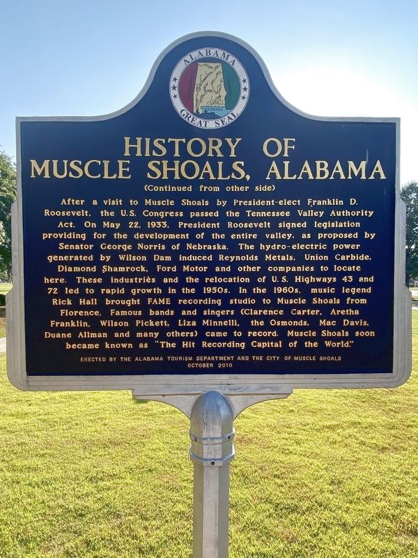
On Jan. 21, 1933 President-elect Franklin Delano Roosevelt addressed an immense crowd at this crossing from his railroad car and promised "to put Muscle Shoals back on the map." He then toured the idle U.S. Nitrate Plant No. 2 and Wilson Dam with . . . — — Map (db m83392) HM
On Main Street (U. S. Highway 11) at Parkway Drive, on the left when traveling east on Main Street (U. S. Highway 11).
A total of 243 houses and 44 duplex units were constructed from 1936 - 1938 at an overall cost of $2,661,981.26. Cahaba residents rented from the government until 1947, when the houses and duplexes were sold to individuals at prices ranging from . . . — — Map (db m26227) HM
Near Hightower Place south of Veterans Drive (Alabama Route 133), on the left when traveling south.
Serving 16 years as president of the American Farm Bureau Federation (1931-1947), Mr. O'Neal developed major New Deal farm policies in the Franklin D. Roosevelt Administration. — — Map (db m219327) HM
On East Magnolia Avenue, 0.1 miles east of North College Street (Alabama Route 15), on the right when traveling west.
Side 1
Auburn
1865~Present
Only one house was built in the village in the decade after the Civil War, and though the state took over the bankrupt college in 1872, the institution received no state appropriation until 1883. . . . — — Map (db m79947) HM
On West Point Parkway (U.S. 29 at milepost 197), 0.6 miles south of County Road 390, on the right when traveling south.
Side 1
Here in 1897 the first iron bridge in Lee County was built. In 1903 George W. Bean bought the mill, operating it until his death in 1952. About 1910 Bean installed an iron overshot wheel to replace the old turbine. Later, the dam . . . — — Map (db m73533) HM
On Monte Sano Blvd Southeast at Highland Plaza Southeast, on the right when traveling north on Monte Sano Blvd Southeast.
This rock entrance is all that remains of Camp Ala. SP-16, 3486 and Camp Ala. TVA-7, 3483 which were built here due to available water. They were part of President Franklin D. Roosevelt's conservation projects. When WW II started the men enlisted . . . — — Map (db m55607) HM
On Twining Street north of Ash Street, on the right when traveling north.
In 1941, before Pearl Harbour, President Franklin D. Roosevelt agreed with Prime Minister Winston S. Churchill, to provide flight training for British and Commonwealth pilots in the U.S.A. by the U.S. Army Air Corps.
Over 4,000 pilots were . . . — — Map (db m64476) HM WM
On Prospect Drive at 7th Street, on the right when traveling west on Prospect Drive.
"This section lying between Sixth Avenue and Eighth Avenue will provide the central beautification theme as it will evolve into a beautiful elevated rose garden with 2,000 selected roses planted at vantage points... the color ensemble, when . . . — — Map (db m86480) HM
On Wheeler Wildlife Boat Launch north of Alabama Route 67, on the right when traveling north.
1838
Trail of Tears: The discovery of gold in Georgia and thirst for land expansion prompted the U.S. Government and white communities to force the Cherokee nation from their ancestral lands. During the summer and winter of 1838, the first . . . — — Map (db m113290) HM
Near Montevallo Road (Alabama Route 119) 0.3 miles south of Alex Mill Road, on the right when traveling south.
(side 1)
The President's Oval Office
In this building is a full-scale replica of the White House Oval Office.
When John and Abigail Adams first moved into The White House in 1800, it contained three oval rooms, inspired by . . . — — Map (db m101531) HM
First United Methodist Church
Jasper
Methodism came to Jasper with the city's founder, Dr. Edward Gordon Musgrove, who donated land for the courthouse and for most of downtown Jasper. In 1826, he and others constructed a building of large . . . — — Map (db m29981) HM
William Brockman Bankhead served Alabama in the U.S. Congress from 1917 until 1940. For the last four years of his life, during Franklin D. Roosevelt's presidency, he served as the 47th Speaker of the House. He was the son of U.S. Senator John . . . — — Map (db m29980) HM
On Elton Britt Avenue just west of Center Street (State Highway 27), on the left when traveling west.
[side 1] Elton Britt, born James Elton Baker, came from the Zack community in Searcy County near the Buffalo River. Britt, from a musical family, was the first million seller in Country Music and received the first Gold Record . . . — — Map (db m229584) HM
Completed in 1934, the Coast Guard Cutter Electra was converted to the presidential yacht and commissioned as a U.S. Navy Vessel, USS Potomac, in 1936. The 165-foot ship, which weighs 376 gross tons and has a cruising speed of . . . — — Map (db m19056) HM
The area where you are now standing was alive with activity during World War II, when it was known as Kaiser Shipyard #2. It was one of four shipyards carved from Richmond's coastline to serve the war effort. The Rosie the Riveter Memorial . . . — — Map (db m94433) HM WM
Here in this grove of enduring redwoods, preserved for posterity, members of the United Nations Conference on International Organization met on May 19, 1945 to honor the memory of Franklin Delano Roosevelt, thirty-first President of the United . . . — — Map (db m144203) HM
In Salute
to the Officers and Men, living and dead, of the
U.S.S. “San Francisco”
a warship named for our city, which though sorely wounded, emerged triumphantly from the Battle of Guadalcanal, November 12-13 1942 after . . . — — Map (db m71479) HM
On Lincoln Boulevard at Keyes Street, on the right when traveling west on Lincoln Boulevard.
Across the street to your left is Building 35. Lives were changed by decisions made here. Originally built as cavalry barracks in 1912, it was converted in 1918 for the School of Bakers and Cooks and then in 1921 to serve as the headquarters of the . . . — — Map (db m132417) HM
Near Hollister Avenue, 0.6 miles west of Cathedral Oaks Road, on the left when traveling west.
On February 23, 1942, at 7:00 PM, during one of President Roosevelt's Fireside Chats,
the Japanese submarine I-17 shelled this Richfield Oil Field site with 25 5-inch rounds.
Not since the War of 1812 had the U.S. mainland been attacked by a . . . — — Map (db m143317) HM
Near Lake Road north of California Highway 89 S, on the right.
The Civilian Conservation Corps (CCC) was established in 1933 under President Franklin D. Roosevelt’s New Deal program.
During the years of the Great Depression, when the stock market crash and ensuing business closures left many Americans . . . — — Map (db m96652) HM
Near Broadway, 0.1 miles north of Canal Drive, on the left when traveling north.
On February 19, 1942, President Roosevelt
issued Executive Order 9066. This order led to
the internment of Japanese Americans, a
majority of whom were United States citizens.
Where you are standing today was once a
temporary detention . . . — — Map (db m153398) HM
On 8th Street east of Grand Avenue, on the right when traveling east.
In the 1930's, America was mired in a deep economic depression. As part of his New Deal program, President Franklin Roosevelt implemented government programs designed to create employment and to stabilize the national economy.
One . . . — — Map (db m120550) HM
In 1867, in Hamburg, Germany, young Adolphus Herman Joseph Kuhrs was preparing to stow away on a ship bound for America. By 1872, Coors had altered the spelling of his last name and arrived in the Denver area. He settled on Golden because of its . . . — — Map (db m74796) HM
On Atlantic Street at Main Street, on the right when traveling north on Atlantic Street.
Freedom Shrine
Created by the National Exchange Club
to strengthen citizen appreciation
of our American heritage
Presented by the Exchange Club of Stamford
Dedicated June 14, 1979
[ Reproductions of historic American documents are . . . — — Map (db m38610) HM
On Legion Road, 0.1 miles south of West River Road, on the right when traveling south.
To honor the men of
Camp White
Company 106
established 1934
Civilian Conservation Corps
1933-1942
created by
President Franklin D. Roosevelt
renewing the country’s natural resources
and challenging the human spirit
of . . . — — Map (db m102082) HM
On Kent Cornwall Road (U.S. 7) 0.4 miles north of Carter Road, on the right when traveling north.
To Honor The Men Of
Camp Macedonia
Company 1191
Established 1935
Civilian Conservation Corps
1933-1942
Created By
President Franklin D. Roosevelt
Renewing The Country's Natural Resources
And Challenging The Human Spirit
Of A . . . — — Map (db m41092) HM
Near Burr Mountain Road, 0.2 miles north of Winsted Road, on the right when traveling south.
To Honor The Men Of
Camp Wolcott
Company 176
Established 1933
Civilian Conservation Corps
1933-1942
Created By
President Franklin D. Roosevelt
Renewing The Country's Natural Resources
And Chellenging The Human Spirit
Of A Nation . . . — — Map (db m30242) HM
Near East 7th Street just east of Swedes Landing Road, on the right when traveling east.
Fort Christina Monument was dedicated here June 27, 1938 celebrating the tercentenary of the landing. Participants included the Swedish Royal Commission led by their royal highnesses, the Crown Prince, the Crown Princess, and Prince Bertil, the . . . — — Map (db m174441) HM
On Chesapeake Street Northwest at River Road Northwest, on the right when traveling west on Chesapeake Street Northwest.
By 1900, 12 large families — often intermarried — came to dominate the village that was Tennallytown: the Burrows, Chappell, Harry, Hurdle, Paxton, Perna, Poore, Queen, Riley, Robey, Shoemaker, and Walther clans.
This is Harry country, . . . — — Map (db m184982) HM
On Pennsylvania Avenue Northwest at 17th Street Northwest, on the right when traveling east on Pennsylvania Avenue Northwest.
Originally State, War, and Navy Departments Constructed 1871-1888 South Wing Ground broken June 1871 Completed December 1875 East Wing Ground broken July 1872 Completed April 1879 North Wing Ground broken July 1879 Completed December 1882 West . . . — — Map (db m71253) HM
On K Street Northwest (U.S. 29) just west of 12th Street Northwest, on the right when traveling west. Reported permanently removed.
Human Being is my attempt to break the wall of xenophobia associated with the Arabic language. Over time, the worldwide Arabic population and the Arabic language has increasingly portrayed in a negative light. The media strongly focuses on . . . — — Map (db m164290) HM
On E Street Northwest west of 15th Street Northwest, on the right when traveling west.
”. . . Now I shall plant, if at all, more for the public than for myself.”
John Quincy Adams, diary entry for July 5, 1826, shortly before beginning the first major planting program at the White House. Massachusetts . . . — — Map (db m61677) HM
On Constitution Avenue Northwest (U.S. 1/50) at 10th Street Northwest, on the right when traveling west on Constitution Avenue Northwest.
The roots of America's top law enforcement agency, the Department of Justice, reach back to 1789. That year the first Congress created the Office of the Attorney General to prosecute lawsuits in the Supreme Court and advise the President and . . . — — Map (db m57214) HM
On Pennsylvania Avenue Northwest at 9th Street Northwest, on the right when traveling east on Pennsylvania Avenue Northwest.
In September, 1941, President Franklin Delano Roosevelt called his friend, Supreme Court Justice Frankfurter, to the White House and asked the Justice to remember the wish he then expressed:
“If any memorial is erected to . . . — — Map (db m31631) HM
Near R Street Northwest just east of 30th Street Northwest, on the left when traveling east.
Co-founder of Czecho-Slovakia. Envoy to France. Pillar of the League of Nations. Advisor to the US presidents W. Wilson, F.D. Roosevelt, H.S. Truman. — — Map (db m189271) HM
On 3rd Street Northwest at U Street Northwest, on the left when traveling north on 3rd Street Northwest.
To your right is Lucy Diggs Slowe Hall, a Howard University dormitory. It opened in 1942 as U.S. government housing for African American women who came to DC to take new war-related jobs or fill in for men who left to join the military during . . . — — Map (db m130836) HM
On Vermont Avenue Northwest at O Street Northwest, on the right when traveling south on Vermont Avenue Northwest.
Born on July 10, 1875, in Mayesville, South Carolina, Mary McLeod Bethune was the daughter of sharecroppers. After attending Scotia Seminary in North Carolina she founded Daytona School for Negro Girls which became Bethune-Cookman College. A . . . — — Map (db m17502) HM
On Vermont Avenue Northwest south of O Street Northwest when traveling north.
This building was the headquarters of the National Council of Negro Women from 1943 to 1966. Political activist and educator Mary McLeod Bethune (1875-1955) founded NCNW in 1935 in her nearby apartment. She moved the organization here eight . . . — — Map (db m130856) HM
On 16th Street Northwest north of Irving Street Northwest, on the left when traveling north.
Beginning in the late 1950s, the community leadership of Mount Pleasant changed from the exclusive Citizens Association to an array of new players. Mount Pleasant Neighbors Association was the first alternative group. It presented festivals and . . . — — Map (db m148598) HM
On Western Ridge Trail, on the right when traveling west.
The granite bench before you commemorates the scholarship, wisdom and skilled diplomacy of Jean Jules Jusserand, French Ambassador to the United States from 1902 to 1925. The memorial's inscription, "Personal Tribute of Esteem and . . . — — Map (db m177624) HM
On Cathedral Avenue Northwest east of Woodley Road Northwest, on the right when traveling west.
The neighborhood of Woodley Park owes its name to the Woodley estate of Philip Barto Key (1767-1815). Key, uncle of Francis Scott Key, who wrote “Star Spangled Banner”, was an officer on the British side during the Revolutionary War. . . . — — Map (db m87469) HM
Near South Capitol Street Southeast at Potomac Avenue Southeast, on the right when traveling north.
Presidential Fans
a. Woodrow Wilson throws out the first pitch on Opening Day, 1916. National Photo Company.
b. Calvin Coolidge and Senators ace Walter Johnson, 1924. National Photo Company.
c. President Herbert . . . — — Map (db m179719) HM
On M Street Southeast east of 7th Street Southeast, on the right when traveling east.
Before air travel, the Navy Yard was the ceremonial gateway to the nation's capital. In 1860, the first Japanese diplomatic mission was welcomed to the United States in an impressive pageant here. Great Britain's George VI and Queen Elizabeth (shown . . . — — Map (db m126456) HM
On 3rd Street Southwest just south of Independence Avenue Southwest, on the right when traveling south.
Henry Kreis
(b. 1899, Essen, Germany - d. 1963, Essex, Connecticut)
This bas relief carving is one of a pair, the first of which stands above the building's Independence Avenue entrance and features a recently . . . — — Map (db m227341) HM
On 4th Street Southwest south of Independence Avenue Southwest, on the right when traveling north.
Emma Lou Davis
(b. 1905, Indianapolis, Indiana - d. 1988, San Diego, California)
In the wake of the Great Depression, one of the chief causes of insecurity was the threat of unemployment. To address this social . . . — — Map (db m227345) HM
On Independence Avenue Southwest near 14th Street Southwest, on the left when traveling west.
James Wilson Memorial Arch
So named by the Congress, in Resolution approved by
President Franklin D. Roosevelt, June 16, 1934,
to honor the memory of
James Wilson
1835-1920
Secretary of Agriculture 1897-1913
. . . — — Map (db m110425) HM
On Jefferson Drive Southwest at 12th Street Northwest, on the right when traveling east on Jefferson Drive Southwest.
United States Department of Agriculture
Dedicated as a Living Reminder in Memory of the Victims of the Holocaust by Secretary Dan Glickman
May 2, 2000
Yom Hashoah, Day of Remembrance
Franklin D. Roosevelt Red Bud from a seed collected at . . . — — Map (db m70618) HM
On 17th Street Southwest north of Independence Avenue Southwest, on the left when traveling north.
Here in the presence of Washington and Lincoln, one the Eighteenth Century father and the other the Nineteenth Century preserver of our nation, we honor those Twentieth Century Americans who took up the struggle during the Second World War and made . . . — — Map (db m4392) HM
Near Ohio Drive Southwest south of West Basin Drive Southwest, on the right when traveling north.
Voters did not know the seriousness of Franklin Roosevelt's heart disease when they elected him to a fourth presidential term. With victory in sight, FDR made a final trip to Eastern Europe and the Middle East. At Yalta, he negotiated post-war . . . — — Map (db m197635) HM
On Ohio Drive Southwest south of West Basin Drive Southwest, on the right when traveling north.
The original 1997 memorial barely hinted at Franklin Roosevelt's paralyzed legs - much as FDR had during his Presidency. Roosevelt's battle with polio was not a secret. The president worried that if people knew he was unable to walk, his . . . — — Map (db m197626) HM
On Ohio Drive Southwest south of West Basin Drive Southwest, on the right when traveling north.
Continuing to combat the Great Depression, President Roosevelt's New Deal created federal programs to stabilize the economy, provide relief, and create jobs for millions of Americans. Most Americans had never heard a president's voice before FDR . . . — — Map (db m197631) HM
On West Basin Drive Southwest east of Ohio Drive Southwest, on the left when traveling west.
In commemoration of his leadership in America’s struggle for peace, well-being and human dignity
Dedicated by President William J. Clinton May 1997. — — Map (db m99914) HM
Near Ohio Drive Southwest south of West Basin Drive Southwest, on the right when traveling north.
World War II began in Asia and Europe in the 1930s. FDR campaigned on keeping the US out of the war while secretly providing weapons and ships to democratic Great Britain without Congress knowing. These resources helped Great Britain fight . . . — — Map (db m197632) HM
Near Ohio Drive Southwest south of West Basin Drive Southwest, on the right when traveling north.
A collapse in the international economic system left one in four Americans out of work. Millions more scrambled for food. New York Governor Franklin Roosevelt ran on a promise of a "New Deal for the American People." He won the 1932 presidential . . . — — Map (db m197629) HM
Near Ohio Drive Southwest, 0.2 miles south of West Basin Drive Southwest, on the right when traveling north.
FDR believed that the failure of an international organization after World War I led directly to World War II. Under Roosevelt's urging, representatives from 26 countries signed a "Declaration by United Nations" in 1942. After FDR died, Eleanor . . . — — Map (db m197637) HM
Near Ohio Drive Southwest south of West Basin Drive Southwest, on the right when traveling north.
FDR said the US must be a "great arsenal for democracy." His administration sent military supplies to allies like Great Britain. After entering World War II, FDR and British Prime Minister Winston Churchill formed a close alliance. American, . . . — — Map (db m197634) HM
Near U.S. 301, 0.2 miles south of East Dr. Martin Luther King Jr. Boulevard, on the right when traveling south.
The United States occupation of Haiti began on July 28, 1915 when 330 US Marines landed at Port-au-Prince on the authority of U.S. President Woodrow Wilson to safeguard the interests of U.S. corporations. It ended on August 1, 1934 after Franklin . . . — — Map (db m194405) WM
On East Base Street (U.S. 90) at Northeast Range Avenue, on the right when traveling west on East Base Street.
The Four Freedoms were stated by President Franklin D. Roosevelt in his Annual Message to Congress, January 6, 1941. Freedom of speech and expression, freedom of worship, freedom from want, and freedom from fear everywhere in the world, became the . . . — — Map (db m149384) HM
Near Southeast 80th Street (County Road 328) at South Pine Avenue (U.S. 441), on the right when traveling east.
Roosevelt EraThe Cross Florida Canal got its start during the Great Depression years. President Franklin D. Roosevelt's efforts to revive the nation's ailing economy involved a wide array of projects and jobs funded by tax-payers. The . . . — — Map (db m237438) HM
Near Southeast 80th Street (County Road 328) at South Pine Avenue (U.S. 441), on the right when traveling east.
"...Requesting the assistance and cooperation of every available federal agency in order to make possible, at an early date, commencement of construction on a ship canal across the peninsula." Message from Florida's Legislature to President . . . — — Map (db m166903) HM
On Overseas Highway (U.S. 1 at milepost 73), 0.8 miles south of Tollgate Boulevard, on the right when traveling south.
The veterans of World War I were promised a bonus but due to the Great Depression of the early 1930s the government was without funds.
Roosevelt was president and formed the Florida Emergency Relief Administration to create jobs for those . . . — — Map (db m116064) HM
On South Elm Avenue just south of West 6th Street, on the left when traveling south.
1 • Helen Keller Southern Magnolia Planted on July 9, 2000 by family in honor of Venus Guess a devoted mother and grandmother. The towering Helen Keller Southern Magnolia may have been one of the trees Helen Keller climbed in the yard . . . — — Map (db m214868) HM
Near East Orange Avenue, 0.1 miles east of South Beach Street, on the left when traveling east.
Just as carefully as Branch Rickey chose Jackie Robinson, he chose Daytona Beach as the site for his "noble experiment.” Dr. Mary McLeod Bethune, founder of Bethune-Cookman College was born July 10, 1875, in Maysville, South Carolina. She was . . . — — Map (db m106464) HM
These cannon, which were captured when Lord Cornwallis surrendered at Yorktown in the American Revolution, were a gift to the Chatham Artillery by President George Washington - a mark of his appreciation for the part the local military company . . . — — Map (db m5517) HM
On Mimosa Boulevard at Bulloch Avenue, on the left when traveling north on Mimosa Boulevard.
Built in the early 1840's by Major James Stephen Bulloch. His second wife, married in 1832, was Martha Elliott. Their second daughter, Martha (Mittie) Bulloch and Theodore Roosevelt married here in 1853. Their son Theodore Roosevelt was the 25th . . . — — Map (db m55963) HM
On Georgia Route 190 at Dowdell Knob Road, on the right when traveling east on State Route 190.
The road extending one mile south traverses a spur which projects into Pine Mountain Valley and terminates in a knob 1395 feet elevation above sea level overlooking a spectacular spread of the valley floor. The knob was named for two pioneer Harris . . . — — Map (db m22013) HM
On Dowdell Knob Road, 1.3 miles south of Pine Mountain Highway (Georgia Route 190), on the left when traveling south.
This overlook, named Dowdell's Knob, was one of the dearest spots on earth to Franklin D. Roosevelt. Named for an early Harris County family, Dowdell's Knob rises to 1,395 feet above sea level and is the highest point on Pine Mountain. Here, on . . . — — Map (db m69519) HM
On Georgia Route 190 at Georgia Route 354, on the right when traveling west on State Route 190.
Pine Mountain Scenic Highway & this bridge, spanning historic King’s Gap, are living monuments to President Roosevelt’s abiding interest in the natural features of Warm Springs’ environs. He, personally, selected the location of this road atop Pine . . . — — Map (db m22020) HM
On Dowdell Knob Road, 1.3 miles south of Georgia Route 190, in the median.
Franklin D. Roosevelt was a frequent visitor (41 trips) to Warm Springs from 1924-1945. Dowdell’s Knob was one of his favorite spots for both quiet contemplation and picnics. F.D.R. visited this spot overlooking Pine Mountain Valley as a private . . . — — Map (db m21998) HM
On State Highway 116 at Minton Lane, on the right when traveling east on State Highway 116.
The Resettlement Administration was founded on May 1, 1935 as part of the second phase of President Roosevelt's New Deal. FDR took a personal interest in the planning of this project with Under Secretary of Agriculture, Dr. Rex Tugwell, . . . — — Map (db m11269) HM
On State Highway 116 at K Street, on the left when traveling east on State Highway 116.
Pine Mountain Valley, Georgia was begun in November 1934 under the administration of Franklin D. Roosevelt and his New Deal plan. It was conceived as a pilot community relief project to provide an escape from the effects of the Great Depression. . . . — — Map (db m11271) HM
On U.S. 341, 0 miles south of Abbott Road, on the right when traveling south.
Dedicated August 11, 1938 by President Franklin D. Roosevelt Rededicated to service 1988
E.J. Martin, Jr., President
W.H. Averett, Jr., V. President
J.H. Gunnels, Secretary
H.B. Cromer, Treasurer
J.H. Barnes, Jr. J.C. Caldwell
F.C. . . . — — Map (db m28215) HM
On College Drive at Summersfield Drive, on the left when traveling north on College Drive.
On August 11, 1938, as many as 50,000 people gathered in the stadium of Gordon Military College for an address by President Franklin Roosevelt dedicating the Lamar Electric Cooperative, a project of the New Deal's Rural Electrification . . . — — Map (db m28214) HM
Near Spring Street (Georgia Route 41) 0.1 miles west of Golf Course Road, on the right when traveling west.
(Panel #1)
Beginning as the Georgia Warm Springs Foundation, this hospital for polio patients was founded by Franklin Delano Roosevelt in 1927.
The Roosevelt Warm Springs Institute for Rehabilitation is today an internationally . . . — — Map (db m84458) HM
Died in this house on April 12 1945
No soldier gave more on any battlefield than he who here gave his life for his country no greater martyr ever served the cause of freedom
This tablet erected June 25 1947 by the Presidential Electors who . . . — — Map (db m66964) HM WM
On Roosevelt Highway (U.S. 27) 0.1 miles east of Juke Line Road, on the right when traveling east.
These gates mark the original entrance to the Georgia Warm Springs Foundation, established in July 1927 by Franklin D. Roosevelt and Basil O’Connor for the treatment of polio victims. Roosevelt himself suffered from polio beginning in 1921. Learning . . . — — Map (db m21442) HM
On U.S. 190, 0.1 miles west of White House Parkway (Route 85W), on the right when traveling east. Reported missing.
In the early years of Franklin D. Roosevelt’s sojourn in Meriwether County, he observed that no great effort was made to replace trees on cut-over or burnt areas not suitable for agriculture.
As a demonstration of replacement, together with . . . — — Map (db m22162) HM
On White House Parkway (Georgia Route 85) at Spring Street (U.S. 27), on the right when traveling north on White House Parkway.
Here stood the little depot of the Southern R. R. where Franklin D. Roosevelt arrived & departed on his many visits to Warm Springs during the years 1924-1945.
A personal interest in the after treatment of infantile paralysis led him, in 1924, to . . . — — Map (db m23072) HM
On White House Parkway (Georgia Route 85W) 0.1 miles north of Georgia Route 190, on the left when traveling north.
Over 2200 acres atop Pine Mountain were purchased 1926-37, by Franklin D. Roosevelt, some 150 acres of which were pasture and crop land -- the rest in pine and hardwoods. The farm was operated on a self-sustaining basis by adherence to methods . . . — — Map (db m22231) HM
Franklin D. Roosevelt came to Warm Springs in 1924 in hopes of recovering from the effects of polio. His love for the area and hopes for the Georgia Warm Springs Foundation led him to build a small white clapboard cottage on these pine scented . . . — — Map (db m42839) HM
On Third Avenue just north of 14th Street, on the right when traveling north.
Built 1887 by Dr. William L. Bullard, Columbus physician and pioneer ear, eye, nose and throat specialist, this house is a splendid example of Second Empire Victorian architecture. It was designed by L.E. Thornton of New York.
The Bullard . . . — — Map (db m44423) HM
Near Main Street (Love Avenue) (U.S. 41) just north of 1st Street East, on the left when traveling north.
Lt. Col. Henry Tift Myers was born in the Myon Hotel in Tifton on September 16, 1907. He graduated from Culver Military Academy in 1925 and the University of Georgia in 1929. He joined the Army Air Corps, graduating at the top of his class in 1932. . . . — — Map (db m197699) HM
On Hamilton Street (U.S. 280) 0 miles east of Washington Street, on the left when traveling east.
Walter F. George was born 1.5 miles north in a sharecropper's cabin. George was a teacher near Preston, then a lawyer and judge. From the Georgia Supreme Court he ran for the unexpired term of Senator Thomas E. Watson in 1922. George served 34 years . . . — — Map (db m56727) HM
The Civilian Conservation Corps (CCC), established by President Franklin Delano Roosevelt in 1933, was one of many "New Deal" Programs created towards economic recovery from the Great Depression. The goal of the CCC was to create Conservation . . . — — Map (db m94340) HM
On Banks Lowman Road (State Highway 17) near Forest Road 555, on the left when traveling west.
(Three panels make up this marker:)
In the 1930s, Gallagher CCC widened and surfaced this road, built Scott Mountain Road, developed Hot Springs and Pine Flat Campgrounds, erected fences to control livestock grazing, fought fires, and . . . — — Map (db m119235) HM
On Jefferson Street at Shoal Creek Avenue, on the right when traveling west on Jefferson Street.
United Mine Workers of America (UMWA) president and Congress of Industrial Organization (CIO) founder John L. Lewis (1880-1969) came to Panama, Illinois, from Iowa with his family in 1908 to work in the mines; within one year he was president to . . . — — Map (db m186233) HM
On East Balboa Avenue near South Michigan Avenue, on the right when traveling west.
An outstanding example of Modern French style of Beaux-Arts Classical architecture. As one of the city's earliest luxury hotels, it became the "Hotel of Presidents," serving as host to a dozen U.S. Presidents, including Woodrow Wilson, Franklin D. . . . — — Map (db m94409) HM
On Lodge Boulevard, on the right when traveling west.
Over the years, about 165,000 individuals were employed in at least 50 Illinois Civilian Conservation Corps camps in Illinois. Many of these worked on projects in Illinois' state parks.
One of the most successful programs to aid Americans . . . — — Map (db m142758) HM
On Tavernier Way, 0.2 miles south of West MacArthur Drive (Illinois Route 111/140), on the left when traveling south.
Theodore Roosevelt Letter On Cuba
On January 22, 1907, President Theodore Roosevelt wrote to Secretary of War William Howard Taft rejecting the idea of a protectorate over Cuba and expressing his determination that the United States should . . . — — Map (db m169581) HM
Near Indiana Route 60, 0.3 miles County Road 950E, on the right when traveling west.
"Created in early 1933, the CCC was an effort by President Franklin Roosevelt to combine the national need for employment with the preservation of natural and historical resources. From May, 1933 until 1942, CCC boys restored village cabins, built . . . — — Map (db m163025) HM
Republican Presidential candidate delivered his acceptance speech at Callaway Park, August 17, 1940.
Willkie’s Democrat opponent, Franklin D. Roosevelt, won the 1940 election and later appointed Willkie to Britain as a liaison during World . . . — — Map (db m243329) HM
On West Walnut Street east of North Capital Avenue, in the median.
Franklin Delano Roosevelt (FDR) and Anna Eleanor Roosevelt (AER) were one of the first power couples in American politics. FDR's sweeping vision helped rescue the United States from the worst economic depression in its history and led the country . . . — — Map (db m132850) HM
On North Delaware Street just north of East 15th Street, on the left when traveling north.
Hoosier author Meredith Nicholson gained prominence in the Golden Age of Indiana Literature (c. 1880-1920) for best-selling novels, starting with The Main Chance (1903). He wrote The House of a Thousand Candles (1905) in this house, . . . — — Map (db m169256) HM
[Main Marker]
Site of
Notre Dame Fieldhouse
where varsity and intramural athletes shook down the thunder for seventy years 1898-1968.
President Franklin D. Roosevelt addressed a special University convocation in the Fieldhouse . . . — — Map (db m12174) HM
On Main Street (State Road 156) at 3rd Street, on the left when traveling south on Main Street.
Patriot, Ind., native; supervised Hoover Dam construction in Colorado R.; Lake Mead named for him; appointed Director, U.S. Bureau of Reclamation, President Coolidge; served under Presidents Hoover and Roosevelt, top authority on irrigation, . . . — — Map (db m66902) HM
On Estates Way at Homestead Drive, in the median on Estates Way.
Dedicated to the original homestead families and their descendants. Brought to fruition through the efforts of the U.S. Government, the Franklin Roosevelt, MGSR. Luigi Ligutti and the Grace of God. In commemoration of the 50th anniversary of the . . . — — Map (db m83950) HM
The story of the Civilian Conservation Corps cannot be told without knowing the tale of the times from which it was created. The stock market crash of 1929, which led to the Great Depression coupled with the lack of soil conservation enabled the . . . — — Map (db m50186) HM
On North Pine Street, on the right when traveling north.
Franklin D. Roosevelt's New Deal and Works Progress Administration was the basis for the construction of Abilene's swimming pool, stadium, rose garden, and other buildings located in this park. This park project under the WPA was one of thirty such . . . — — Map (db m49551) HM
302 entries matched your criteria. The first 100 are listed above. Next 100 ⊳