On Forest Road (U.S. 221) east of Venture Drive, on the right when traveling west.
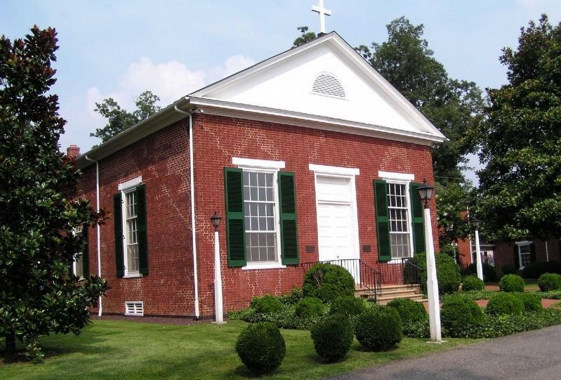
Half a mile north is St. Stephen's Church, built about 1825 under Rev. Nicholas Cobb, later Bishop of Alabama. In the old cemetery here many members of early families of the community are buried. — — Map (db m42894) HM
On Interpretive Trail, 1.7 miles south of State Park Road, on the right.
Appalachian Power Company constructed Smith
Mountain and Leesville Dams between 1960 and
1963 to generate hydroelectric energy. The waters
of the Roanoke and Blackwater Rivers formed Smith
Mountain Lake, one of two resulting reservoirs,
which . . . — — Map (db m104439) HM
On West Lynchburg Salem Turnpike (U.S. 460) 0.3 miles west of Circle K Road (Virginia Route 751), in the median.
Near here stood a fortified dwelling used for shelter during periods of warfare between European colonists and Native Americans. To this fort in 1756 came Mary Draper Ingles (Mrs. William Ingles) for protection following her escape from captivity by . . . — — Map (db m42851) HM
On West Lynchburg Salem Turnpike (U.S. 460) 0.2 miles west of Thaxton School Road (Virginia Route 831), on the right when traveling west.
On 2 July 1889, a heavy storm turned nearby Wolf Creek into a raging river. The railroad embankment known as Newman’s Fill, just north of here, became saturated. About 1:25 AM, it collapsed under the weight of Norfolk & Western Passenger Train . . . — — Map (db m84781) HM
On East Lynchburg-Salem Turnpike (U.S. 460) west of Ryland Drive, on the right when traveling west.
Nearby are buried several prominent area settlers and their descendants. Col. William Callaway, in 1755 one of the first two members of the Virginia House of Burgesses from Bedford County, donated the hundred acres of land on which the town of New . . . — — Map (db m65605) HM
On South Scenic Highway (U.S. 52) at Seddon Street (County Route 1005), on the right when traveling west on South Scenic Highway.
The community center was first known as Crab Orchard. The place became the county seat of Bland County when it was formed in 1861 under the name of Seddon, which was later changed to that of the county. At Rocky Gap a skirmish was fought in Crook’s . . . — — Map (db m44855) HM
On South Scenic Highway (Route 52) 0.5 miles west of Waddletown Road (Virginia Route 617), on the right when traveling west. Reported permanently removed.
Here is the home of S.H. Newberry, who, with three others, composed the "Big Four" in the Virginia Senate. These four men united to defeat objectionable measures of the readjuster movement. — — Map (db m176393) HM
On Stony Fork Road (U.S. 52) near West Blue Grass Trail (Virginia Route 42), on the right when traveling south.
Samuel H. Newberry, a captain in the Confederate army who represented Bland and Pulaski Counties in the Virginia House of Delegates from 1865 to 1867, lived here at Eagle Oak. Newberry served in the Senate of Virginia during the 1870s and 1880s and . . . — — Map (db m43138) HM
On West Blue Grass Trail (Virginia Route 42) at Poor Valley Road (County Route 625) on West Blue Grass Trail.
Henry Casper Groseclose (1892–1950), a
native of Ceres, was one of the founders of
Future Farmers of Virginia (FFV). While teaching agricultural education at Virginia Polytechnic
Institute, Groseclose, Walter Newman, Edmund Magill, and . . . — — Map (db m44219) HM
On North Scenic Highway (U.S. 52) at Interstate 77, on the right when traveling south on North Scenic Highway.
William Elbert Munsey was born a few miles
east in the mountains of Giles (present-day Bland)
County on 13 July 1833. Despite little formal
schooling, Munsey possessed an insatiable
appetite for knowledge. He entered the ministry
of the . . . — — Map (db m44810) HM
On Stoney Fork Road (U.S. 52) at Old Mountain Road (County Route 621), on the right when traveling south on Stoney Fork Road.
Wythe County. Area 479 Square Miles. Formed in 1789 from Montgomery, and named for George Wythe, signer of the Declaration of Independence. New River flows through this county.
Bland County. Area 360 Square . . . — — Map (db m44146) HM
On Lynchburg Salem Turnpike (U.S. 460), on the right when traveling east.
Botetourt County. Area 548 Square Miles. Formed in 1769 from Augusta, and named for Lord Botetourt, Governor of Virginia, 1768–1770. Buchanan was the western terminus of the noted James River and Kanawha Canal.
Bedford . . . — — Map (db m57734) HM
On Main Street (U.S. 11), on the right when traveling south. Reported missing.
The town was established in 1811 and named for Colonel John Buchanan, pioneer and soldier. It was incorporated in 1833. Its importance consisted in its being the western terminus of the James River and Kanawha Canal, which reached the town in 1851. . . . — — Map (db m23810) HM
On Main Street (U.S. 11), on the right when traveling south.
Looney's Ferry, established in 1742, was the first crossing over James River in this region. On the other side of the river was Cherry Tree Bottom, home of Colonel John Buchanan, and above the mouth of this creek stood Fort Fauquier, 1758-1763. — — Map (db m23823) HM
On Lee Highway (U.S. 11) north of Updike Lane, on the right when traveling north.
Robert Harvey established an agricultural and industrial complex here about 1790 that processed iron ore. The operation, known as Cloverdale Furnace, expanded in the 19th century under the ownership of John Tayloe III. About 150 enslaved African . . . — — Map (db m140513) HM
On Lee Hwy (U.S. 11) south of 2nd Avenue, on the right when traveling north.
This is the old road from Pennsylvania to the Yadkin Valley, over which in early times settlers passed going south. On it were the Black Horse Tavern and the Tinker Creek Presbyterian Church. — — Map (db m62980) HM
On Roanoke Road (U.S. 220), on the right when traveling south.
Daleville College began as a private school that Church of the Brethren educator Isaac N. H. Beahm conducted for the children of Benjamin F. Nininger and George Layman in 1890. The construction of school buildings began the following year. In 1892, . . . — — Map (db m63212) HM
On Roanoke Road (U.S. 220) south of International Parkway, in the median.
Half a mile west stood Greenfield, the home of Col. William Preston. According to local tradition, Stephen Rentfroe constructed a fort there in the 1740s. In 1759, Preston bought the property from Rentfroe and soon built a house that evolved into a . . . — — Map (db m62983) HM
On Main Street (Local Road T-630) at Roanoke Street (Local Road T-1204), on the left when traveling east on Main Street.
On 15 December 1970, fire gutted the 1848 Greek
Revival-style Botetourt County courthouse.
Amid the charred wreckage, in a secure vault,
the county’s historic records fortunately
survived almost unharmed. Because of the
near-loss of the . . . — — Map (db m84188) HM
On Breckinridge Mill Road (County Route 600) 1 mile south of Grove Hill Road (Route 606), on the left when traveling south.
Breckinridge Mill is a rare survivor of the grain and milling industry that figured significantly in the economy of antebellum Virginia. The three-and-a-half story brick structure was erected in 1822 for James Breckinridge, and is one of the oldest . . . — — Map (db m84225) HM
On Fincastle Road (U.S. 220) at West Main Street (Local Route T-630), on the right when traveling north on Fincastle Road.
Miller’s place here was selected as the county seat of Botetourt in 1770. In 1772 the town of Fincastle was established on land donated by Israel Christian and named for Lord Fincastle, eldest son of Governor Lord Dunmore. It was incorporated in . . . — — Map (db m84192) HM
On Roanoke Road (U.S. 220) at Trinity Road, on the right when traveling north on Roanoke Road.
Col. William Preston constructed Fort William nearby in 1755 during the French and Indian War (1754 – 1763) as one in a series of fortifications to protect Virginia’s frontier. A group of Indians paid a friendly visit in Oct. 1755, and Col. George . . . — — Map (db m62979) HM
On Botetourt Road (U.S. 220) at Houseman Street (County Route 1211), on the left when traveling north on Botetourt Road.
Near here is Santillane, one of Botetourt County’s
most distinguished properties. The Greek Revival house sits on a tract of land originally
owned by Colonel George Hancock, a member
of the United States Congress from 1793-1797.
In 1808 . . . — — Map (db m84203) HM
On Botetourt Road (Route 220) at Poor Farm Road (Route 681), in the median on Botetourt Road.
The (Roanoke) Valley Baptist Association was organized on 7 August 1841 at nearby Zion Hill Baptist Church. Seventeen congregations constituted the original fellowship of churches; during the next century and a half membership grew to more than . . . — — Map (db m84226) HM
On Arcadia Road (Virginia Route 614) near Lee Highway (Virginia Route 055), on the right when traveling west. Reported permanently removed.
This gap, just west, is named for Henry Cartmill who acquired land nearby on Purgatory Creek. During the French and Indian War (1754-1763), conflicts between Indians and settlers increased in this area. In 1757, Indians laid waste to several nearby . . . — — Map (db m18817) HM
On Lee Highway (Route F055 Frontage Road) south of Plank Road (County Route 610), on the left when traveling north.
Nearby stood Capt. Audley Paul’s fort, built
in 1757 during the French and Indian War
(1754-1763) as one in a series of fortifications
to protect Virginia's frontier. Paul served as
a lieutenant in Maj. Gen. Edward Braddock’s
ill-fated . . . — — Map (db m43110) HM
On Lee Highway (U.S. 11), on the right when traveling south.
Near here took place the historic meeting of John C. Moomaw and C. M. Thomas that led to the termination of the Shenandoah Valley Railroad at Big Lick (now Roanoke), April, 1881. This was the beginning of the city of Roanoke. — — Map (db m23824) HM
On Martin Luther King Jr. Boulevard (Virginia Route 113) north of State Street, on the right when traveling north.
The Rev. James King donated land for railroad facilities here in 1848, before the town of Bristol took root early in the 1850s. The first passenger train arrived on 1 Oct. 1856 on the railroad later known as the Norfolk and Western (N&W). In 1858, . . . — — Map (db m133882) HM
On Lee Highway (U.S. 11/19) west of Sugar Hollow Road, on the right when traveling west.
The Sapling Grove tract (Bristol) was surveyed for John Tayloe, 1749. It was owned by Isaac Baker and Evan Shelby, who built a post about 1770. The Virginia tract was bought by John Goodson, whose son founded the town of Goodson, incorporated in . . . — — Map (db m210154) HM
On Lee Street north of Cumberland Street (Virginia Route 113), on the left when traveling north.
Charles S. Johnson, sociologist, author, and civil rights leader, was born in Bristol, son of a 42-year pastor of Lee Street Baptist Church. He attended Virginia Union University and the University of Chicago and served in combat during World War I. . . . — — Map (db m210163) HM
On State Street at Edgemont Avenue on State Street.
Evan Shelby, noted Indian fighter, settled here about 1765 on a tract called "Sapling Grove". His home was a neighborhood fort, the refuge of settlers in Indian attacks. Bristol grew around this place and became an early railroad center. — — Map (db m24323) HM
On Lee Street north of Cumberland Street (Virginia Route 113), on the left when traveling north.
In 1865, at the dawn of their freedom from slavery, 42 former members of the white-led Goodson (now First) Baptist Church organized the Anglo African Baptist Church. The congregation met in a series of buildings until, under the leadership of the . . . — — Map (db m210167) HM
On Lee Highway (U.S. 11/19) 0.1 miles west of Forsythe Road, on the right when traveling west.
Col. Robert Preston (1750-1833) acquired 720 acres here in the 1780s and established Walnut Grove. Preston had emigrated from Ireland in 1773 and worked as assistant surveyor under his relative William Preston, who laid out vast areas of western . . . — — Map (db m210159) HM
On Boydton Plank Road (U.S. 1) at Christanna Highway (Virginia Route 46), on the right when traveling north on Boydton Plank Road.
Nearby to the south stood Fort Christanna, a wooden structure built in 1714 under the auspices of Alexander Spotswood and the Virginia Indian Company. Members of the Meiponsky, Occaneechi, Saponi, Stuckenock, and Tutelo Indian tribes lived within . . . — — Map (db m20181) HM
On Boydton Plank Road (U.S. 1) at Christanna Highway (Virginia Route 46), on the right when traveling north on Boydton Plank Road. Reported permanently removed.
Here the first courthouse of Brunswick County was built about 1732. In 1746, when the county was divided, the county seat was moved east near Thomasburg. In 1783, after Greensville County had been formed, the courthouse was moved to Lawrenceville. — — Map (db m20180) HM
On Boydton Plank Road (U.S. 1) 0.2 miles north of Poor House Road (County Route 642), on the right when traveling south.
A branch of the Nottoway, named for the huge fish once caught in it. William Byrd, returning from the expedition to survey the Virginia-North Carolina boundary line, camped on this stream in November, 1729. — — Map (db m62406) HM
On Christanna Highway (Virginia Route 46) south of Jonesboro Church Road (County Road 645), on the right when traveling south.
According to local tradition, while Dr. Creed Haskins and several friends were on a hunting trip in Brunswick County in 1828, his camp cook, Jimmy Matthews, hunted squirrels for a stew. Matthews simmered the squirrels with butter, onions, stale . . . — — Map (db m107700) HM
On Boydton Plank Road (U.S. 1) 0.6 miles south of Tanner Town Road, on the right when traveling north.
According to local tradition, while Dr. Creed Haskins and several friends were on a hunting trip in Brunswick County in 1828, his camp cook, Jimmy Matthews, hunted squirrels for a stew. Matthews simmered the squirrels with butter, onions, stale . . . — — Map (db m20188) HM
On Piney Pond Road (U.S. 58) 0.1 miles west of Main Street (County Route 659), on the left when traveling west.
Mecklenburg County. Formed in 1764 from Lunenburg, and named for Princess Charlotte, of Mecklenburg-Strelitz, queen of George III. A small army under the command of rebel Nathaniel Bacon destroyed the town of the Occaneechee Indians near . . . — — Map (db m30875) HM
On Christanna Highway (Virginia Route 46) at Boydton Plank Road (U.S. 1), on the right when traveling south on Christanna Highway.
Nellie Pratt Russell, educator, attended Howard
University and was one of six incorporators of
Alpha Kappa Alpha Sorority, the first Greek
letter organization founded by African American
women. The sorority, established in 1908, . . . — — Map (db m107412) HM
On Old Stage Road, 0.4 miles south of Smoky Ordinary Road.
The ordinary that stood on this site catered to travelers on the north-south stage road as early as 1750. During the American Revolution local warehouses were burned by British Colonel Tarleton, and legend says that it was from that occurrence that . . . — — Map (db m20164) HM
On Pleasant Shade Drive / Governor Harrison Parkway (U.S. 58) at 5 Forks Access Road, on the right when traveling west on Pleasant Shade Drive / Governor Harrison Parkway.
Brunswick County. Formed in 1720 from Prince George, Surry, and Isle of Wight. Named for the House of Brunswick, which came to the throne of England in 1714, when George I was crowned king. Colonial Fort Christanna was in this county. . . . — — Map (db m60468) HM
On Pleasant Shade Drive / Governor Harrison Parkway (U.S. 58) at 5 Forks Access Road, on the right when traveling west on Pleasant Shade Drive / Governor Harrison Parkway.
According to local tradition, while Dr. Creed Haskins and several friends were on a hunting trip in Brunswick County in 1828, his camp cook, Jimmy Matthews, hunted squirrels for a stew. Matthews simmered the squirrels with butter, onions, stale . . . — — Map (db m60633) HM
On Christanna Highway (Virginia Route 46) 0.7 miles south of Iron Bridge Road (County Road 715), on the right when traveling south.
Nearby to the south stood Fort Christanna, a wooden structure built in 1714 under the auspices of Alexander Spotswood and the Virginia Indian Company. Members of the Meiponsky, Occaneechi, Saponi, Stuckenock, and Tutelo Indian tribes lived within . . . — — Map (db m20184) HM
On North Main Street (Business U.S. 58) at Athletic Field Road, on the right when traveling west on North Main Street.
Saint Paul's College was established in 1883 by the Venerable James Solomon Russell (1857-1935) as an Episcopal mission school to serve the black community of Southside Virginia. Born into slavery in Mecklenburg County, Russell was educated at . . . — — Map (db m20187) HM
On Brunswick Drive (County Route 644) at Exit 24 (Interstate 85) on Brunswick Drive.
Among the earliest of the more than a dozen
Julius Rosenwald Schools built in Brunswick
County, Saint Paul’s Chapel School was constructed
as a one-teacher standard plan in 1920 under
the initial wave of Tuskegee Institute-administered building . . . — — Map (db m107433) HM
On Christanna Highway (Virginia Route 46) 0.5 miles north of Gasburg Road (County Road 626), on the right when traveling north.
The Brunswick Circuit, established in 1773 by Robert Williams, is likely the oldest Methodist circuit in America. It extended from Petersburg south into North Carolina, and became known as “the cradle of Methodism in the South.” By 1776, the . . . — — Map (db m60671) HM
On Christanna Highway (Virginia Route 46) near Dromgoole Road (County Road 669), on the right when traveling north.
According to local tradition, while Dr. Creed Haskins and several friends were on a hunting trip in Brunswick County in 1828, his camp cook, Jimmy Matthews, hunted squirrels for a stew. Matthews simmered the squirrels with butter, onions, stale . . . — — Map (db m60672) HM
On Christanna Highway (Virginia Route 46) 0.1 miles south of Gasburg Road (County Road 626), on the left when traveling north.
Near here stood Mason's Chapel, one of the earliest Methodist churches in southern Virginia. The first Virginia conference, May, 1785, was held here or nearby; Bishop Asbury presided. The conference of 1801 was held here. The present Olive Branch . . . — — Map (db m60673) HM
On Boydton Plank Road (U.S. 1) at Old Stage Road (County Route 712), on the right when traveling north on Boydton Plank Road.
At Birch's Bridge (very near this bridge) the second William Byrd and his party crossed the river, in September, 1733, on their way to inspect Byrd's land holdings in North Carolina. Byrd wrote an account of this trip which he called “A . . . — — Map (db m62403) HM
On Boydton Plank Road (U.S. 1) at Old Stage Road, on the right when traveling south on Boydton Plank Road.
According to local tradition, while Dr. Creed Haskins and several friends were on a hunting trip in Brunswick County in 1828, his camp cook, Jimmy Matthews, hunted squirrels for a stew. Matthews simmered the squirrels with butter, onions, stale . . . — — Map (db m20186) HM
On Boydton Plank Road (U.S. 1) at Old Stage Road (County Route 712), on the right when traveling north on Boydton Plank Road.
Dinwiddie County. Area 521 Square Miles. Formed in 1752 from Prince George, and named for Robert Dinwiddie, Governor of Virginia 1751-1756. General Winfield Scott was born in this county, and in it took place the battle of Five . . . — — Map (db m62404) HM
On Boydton Plank Road (U.S. 1) 0.1 miles south of Flat Rock Road (County Route 643), on the right when traveling north.
A few hundred yards east is the site of Ebenezer Academy, founded in 1793 by Bishop Asbury, the first Methodist school established in Virginia. It passed out of the hands of the church but remained a noted school for many years. — — Map (db m62405) HM
On U.S. 460 just east of the Kentucky State Line, on the left when traveling west.
Buchanan County. Formed in 1858 from Tazewell and Russell and named for James Buchanan, President of the United States, 1857–1861.
Kentucky. The first permanent settlement was made at Harrodsburg in 1774. Kentucky County was . . . — — Map (db m89744) HM
On Main Street at Walnut Street (Local Route T-1003), on the left when traveling south on Main Street.
This place became the county seat when Buchanan County was formed, in 1858, and was probably named for Felix Grundy of Tennessee, Statesman. In October, 1864, the Union General Burbridge passed through Grundy on his raid to Saltville. The town was . . . — — Map (db m89737) HM
On Red Bud Highway (Virginia Route 80) just west of Chimney Rock Road, on the right when traveling west.
Buchanan County. Area 514 square miles. Formed in 1858 from Tazewell and Russell, and named for James Buchanan, President of the United States, 1857–1861.
Russell County. Area 496 square miles. Formed in . . . — — Map (db m104942) HM
On U.S. 460 south of Shortt Gap Road, on the right when traveling north.
Buchanan County Buchanan County is situated in the heart of
Southwest Virginia's coalfields in the Appalachian
Plateau and was formed from Tazewell and
Russell counties in 1858. The county is named
for James Buchanan who served as president . . . — — Map (db m228601) HM
On James Madison Highway (U.S. 15) at Circle Drive Road (County Route 715), on the right when traveling south on James Madison Highway.
The name Arvonia was derived from Caernarvon, Wales, home to the Welsh quarrymen who settled the area in the mid-19th century. Arvonia is known for the long-lasting and unfading blue-black Buckingham slate that adorns many of Virginia's historic . . . — — Map (db m28974) HM
On Anderson Highway (U.S. 60) at Mount Rush Highway (Virginia Route 24), on the right when traveling east on Anderson Highway.
About two miles south and one-half mile west is the geographical center of the state. Latitude: 37° 30.6' north Longitude: 78° 37.5' west — — Map (db m21133) HM
On Anderson Highway (U.S. 60) 0.4 miles west of Ayers Road, on the left when traveling west.
Buckingham County. Area 584 square miles. Formed in 1761 from Albemarle, and named for Buckinghamshire, England. Peter Francisco, noted Revolutionary soldier, lived in this county.
Cumberland County. Area 293 square . . . — — Map (db m21134) HM
On East James Anderson Highway (U.S. 60) 0.2 miles east of Scotts Bottom Road (Virginia Route 632), on the right when traveling east.
Robert Bolling, member of the House of Burgesses, lived near here at his home Chellowe. A prolific writer, he published many poems as well as a treatise on wine-making. In 1766, Bolling precipitated a crisis when in an article in the Williamsburg . . . — — Map (db m74003) HM
On James Madison Highway (U.S. 15) at Old Curdsville Road (County Route 633), on the right when traveling north on James Madison Highway. Reported permanently removed.
Part of Lee's army passed here retreating westward, April 8, 1865. The Sixth (Wright's) Corps of Grant's Army passed here, in pursuit, in the afternoon of the same day, moving on toward Appomattox. — — Map (db m28112) HM
On South Madison Road (U.S. 15) at School Road (Virginia Route 633), on the right when traveling north on South Madison Road.
Confederate Gen. Robert E. Lee's surplus artillery and wagon trains, under Brig. Gen. Reuben Lindsay Walker, passed here on the night of 7 April 1865, retreating westward along the Buckingham Plank Road. Lee, traveling with Lt. Gen. James . . . — — Map (db m181207) HM
On North Madison Road (U.S. 15) at South Constitution Route (State Highway 20), on the right when traveling south on North Madison Road.
One mile southeast stood Buckingham Training School, the first high school in the county for African American students. In 1919 the Rev. Stephen J. Ellis organized the County-Wide League for School Improvement to persuade the Buckingham County . . . — — Map (db m29157) HM
On James Madison Highway (U.S. 15) at Gravel Hill Road (Virginia Route 617), on the right when traveling north on James Madison Highway. Reported permanently removed.
Two miles east is the site of the first college for women in Virginia, the Female Collegiate Institute. Opened in 1837, it failed in 1843. Reopened in 1848, it survived until 1863. The school building has been destroyed but the "President's Cottage" . . . — — Map (db m21128) HM
On North James Madison Highway (U.S. 15) at Gravel Hill Road (Virginia Route 617), on the right when traveling north on North James Madison Highway.
About two miles east, along the Richmond-Lynchburg stage road, is the site of the Female Collegiate Institute, the first college for women chartered in Virginia. Established in 1837, the college offered a rigorous curriculum including courses in . . . — — Map (db m181218) HM
On North Madison Road (U.S. 15) at Gold Mine Street (Alternate County Route 1010), on the right when traveling south on North Madison Road.
This was the most notable gold-mining region in the country before the California gold rush in 1849. The Morrow Mine here, opened before 1835, was one of the earliest gold mines in which underground mining was employed. Profitably worked for a . . . — — Map (db m29159) HM
On James Madison Highway (U.S. 15) at County Route 687, on the right when traveling south on James Madison Highway.
Buckingham County. Located in the geographical center of Virginia, Buckingham County, the only county in the United States to bear that name, was formed in 1761 from Albemarle County. It is not known for which of the many Buckinghams in . . . — — Map (db m31358) HM
On James Madison Highway (U.S. 15) at Toney Lane, on the right when traveling north on James Madison Highway.
Three miles east is the birthplace of the noted teacher, educator and historian, Dr. Carter G. Woodson. He was the founder of the Association for the Study of Negro Life and History, Journal of Negro History, originated negro history week and . . . — — Map (db m28972) HM
On James Madison Highway (U.S. 15) at C. G. Woodson Drive (County Route 670), on the right when traveling north on James Madison Highway.
Carter Godwin Woodson was born about three miles east on 19 December 1875. As a youth he mined coal near Huntington, W. Va. He earned degrees at Berea College (B.L., 1903), University of Chicago (B.A. and M.A., 1908), and Harvard (Ph. D., 1912) -- . . . — — Map (db m28977) HM
On James Madison Highway (U.S. 15) 0.3 miles north of Trents Mill Road (Virginia Route 622), on the right when traveling north.
The original or southwest wing was erected about 1758 as a church for the newly-formed Tillotson Parish. It was abandoned following the Disestablishment of the Anglican Church in Virginia in 1784, and thereafter was acquired by the Buckingham . . . — — Map (db m21131) HM
On James Madison Highway (U.S. 15) 0.2 miles north of Glen Road (County Route 686), on the right when traveling north.
On this site in July 1933, CCC Camp P-56 Company 1367, opened with an enrollment of 192 Virginia men. The camp, which was organized as one of President Franklin Delano Roosevelt's New Deal employment programs, consisted of 52 small barracks, a large . . . — — Map (db m28307) HM
On James Madison Highway (U.S. 15) at Evans Mill Road (County Route 621), on the right when traveling north on James Madison Highway.
Approximately 2 miles east stood Millbrook (1811-1866), home of U.S. Senator John Wayles Eppes (1773-1823). He attended the University of Pennsylvania, was graduated from Hampden-Sydney College, and was admitted to the Bar in 1794. He married Maria, . . . — — Map (db m28305) HM
On James Madison Hwy (U.S. 15) at Francisco Road (Virginia Route 636), on the right when traveling south on James Madison Hwy.
Part of Lee’s army passed here, April 8, 1865, retreating westward. The second (Humphrey’s) Corps of Grant’s army passed, in pursuit, in the afternoon of the same day. Grant spent the night here, receiving early in the morning of April 9 a note from . . . — — Map (db m11864) HM
On James Madison Highway (U.S. 15) at Francisco Road (County Route 626), on the right when traveling south on James Madison Highway.
Four miles west is the site of New Store Village, in early times an important stop on the stage coach road between Richmond and Lynchburg. Philip Watkins McKinney, governor of Virginia 1890-1894, was born here in 1832. Peter Francisco, Revolutionary . . . — — Map (db m29166) HM
On West 29th Street (U.S. 60) west of Culvert Street (County Route 631), on the left when traveling west.
Here was Moomaw’s Landing, on the North River Canal. In May 1863 the packet Marshall passed here bearing the body of General Thomas J. (“Stonewall”) Jackson to Lexington. Mrs. Robert E. Lee used the canal in 1865 to join her husband at . . . — — Map (db m50374) HM
On Main Street (Business U.S. 29) at Wards Droad (U.S. 29), on the left when traveling south on Main Street.
During the Revolutionary War, loyalists in the
Virginia backcountry periodically conspired
against the Revolutionary authorities. Colonels
Charles Lynch, James Callaway, and other militia
officers and county justices formed extralegal
courts to . . . — — Map (db m65382) HM
On Wickliffe Road (Virginia Route 40) at Pick Street, on the right when traveling east on Wickliffe Road.
Lt. Gen. Lewis Andrew Pick was born here on November 18, 1890. Educated at Rustburg and at VPI, (where he was a member of the Corps of Cadets), General Pick served in two World Wars and in the Korean Conflict. Best known as the builder of the . . . — — Map (db m64424) HM
On Swinging Bridge Road (County Route 605) at Wickliffe Road (Virginia Route 40), on the right when traveling west on Swinging Bridge Road.
Four and a half miles north stands Hat Creek Presbyterian Church, founded by John Irving and associates (first settlers) about 1742. William Irving, son of John, and the noted blind preacher, James Waddel, were among its pastors. The first log . . . — — Map (db m122066) HM
On Wickliffe Road (Virginia Route 40) at Mt. Calvary Road (County Route 600), on the right when traveling east on Wickliffe Road.
Five miles southeast Is Red Hill the last
home and burial place of Patrick Henry,
governor of Virginia and the great orator
of the American Revolution. Henry is
especially famous for his “Liberty or Death”
speech made in 1775 in Saint John’s . . . — — Map (db m64382) HM
On Main Street south of East Rush Street (County Route 1103), on the right when traveling south.
Five miles east is Red Hill, last home and grave of Patrick Henry, orator of the Revolution. He moved there in 1796 and died there, June 6, 1799. Henry is especially famous for his “Liberty or Death” speech made in 1775 at the beginning of the . . . — — Map (db m64431) HM
On Lusardi Drive (U.S. 501) at Rush Street when traveling north on Lusardi Drive.
Five miles east is Red Hill, the last home and
gravesite of Patrick Henry, the great orator
of the Revolution. Henry is especially famous
for his “Liberty or Death” speech made in
1775 in St. John’s Church in Richmond. Henry
moved . . . — — Map (db m64434) HM
On Brookneal Highway (U.S. 501) near Pigeon Run Road (County Route 652), on the right when traveling south. Reported missing.
Two miles east is Shady Grove, which was built in 1825 by Dr. George Cabell, of Point of Honor in Lynchburg, for his daughter Paulina and her husband Alexander Spotswood Henry, son of Patrick Henry. Shady Grove is a handsomely proportioned and . . . — — Map (db m64247) HM
On Richmond Highway (U.S. 460) 0.3 miles west of Mount Athos Road (County Route 726), on the right when traveling east.
Two miles north stand massive sandstone walls and four chimneys, the ruins of Mount Athos, overlooking a bend of the James River. The house was built about 1800 for William J. Lewis (1766-1828) on land that had been patented in 1742 by John Bolling . . . — — Map (db m42896) HM
On Richmond Highway (U.S. 460) 0.1 miles east of Oxford Furnace Road (County Route 662), on the right when traveling west.
Just south across Little Beaver Creek stand the ruins of the last of three Oxford Iron Works furnaces built in the vicinity. Virginia and Pennsylvania investors began the ironworks nearby between 1768 and 1772 as a small bloomery forge. According to . . . — — Map (db m42897) HM
On Alum Springs Road (County Route 858) at Town Fork Road (County Route 623), on the right when traveling east on Alum Springs Road.
This place, on the old stage road, was the first county seat of Bedford; the first courthouse, built in 1755, was standing until 1856. In 1781, New London was raided by the British cavalryman, Tarleton, seeking military stores. It came into Campbell . . . — — Map (db m65383) HM
On Village Highway (Virginia Route 24) just west of Red House Road (County Road 615), on the right when traveling west.
Campbell County Training School (CCTS) opened here ca. 1923 after African American citizens campaigned for better schools. The black community, the county, and the Julius Rosenwald Fund paid for its construction. Rosenwald, inspired . . . — — Map (db m181140) HM
On Village Highway (Virginia Route 24), on the right when traveling west.
Born in Lynchburg in 1913, Col. Vincent W.
“Squeek” Burnett learned to fly at age 16.
By the mid-1930s, he was one of America’s
renowned aerobatic pilots and a member of
the Flying Aces Air Circus. He performed
such signature . . . — — Map (db m64207) HM
On Village Highway (Route 501) near Rails End Lane (County Route 838), on the right when traveling south.
Rustburg was named after Jeremiah Rust, who patented land here in 1780. Rust donated 50 acres of land, known as Rust Meadows, in 1784, for the county seat of Campbell County. A temporary courthouse and other public buildings were constructed . . . — — Map (db m65564) HM
On North Main Street (Business U.S. 301) at West Broaddus Avenue (Route 207), on the left when traveling north on North Main Street.
Born in Washington D.C., John Cephas grew up
there and in Caroline County. He was influenced
at an early age by his mother's singing. A cousin
taught him the highly syncopated and danceable
guitar style now known as Piedmont Blues, . . . — — Map (db m75730) HM
On Washington Highway (U.S. 1) at Oxford Road, on the right when traveling north on Washington Highway.
The earthworks in the angle between this stream and the North Anna River, held by a small Confederate force, were taken by Grant's troops moving southward on May 23, 1864. The Unionists then advanced to the river, on the south side of which was . . . — — Map (db m86146) HM
On Ladysmith Road (County Route 639) at Countyline Church Road (County Route 603), on the right when traveling east on Ladysmith Road.
William Clark was born to John and Ann Rogers
Clark on 1 Aug. 1770 on the family farm about
one mile north. The Clark family moved to Louisville, Kentucky, in 1784. William Clark served in
the Kentucky militia and in the Indian campaigns
in the . . . — — Map (db m22561) HM
On Washington Highway (U.S. 1), on the right when traveling north.
Caroline County. Area 529 Square Miles. Formed in 1727 from Essex, King and Queen, and King William. Named for Queen Carline, wife of King George II. George Rogers Clark, Conqueror of the Northwest, passed his youth in this . . . — — Map (db m10642) HM
On Dawn Boulevard (Virginia Route 30), on the right when traveling east.
On this site overlooking the North Anna River, archaeological investigations conducted in 2006 in cooperation with Virginia tribes identified toolmaking camps dating to 8000 B.C. Indians used these camps repeatedly, especially from about 1000 B.C. . . . — — Map (db m10640) HM
On Washington Highway (U.S. 1), on the right when traveling north.
Lee and Grant faced each other on the North Anna, May 23-26, 1864. Union forces crossed here and four miles to the west but found they could not dislodge Lee's center, which rested on the stream. Grant then turned east to Cold Harbor. — — Map (db m10644) HM
On Dawn Blvd. (Virginia Route 30) 1.8 miles east of Interstate 95, on the left when traveling east.
This famous horsebreeding farm was established in 1936 by Christopher T. Chenery and continued under the management of his daughter, Helen “Penny” Chenery until 1979. Secretariat (1970–-1989), also known as “Big Red,” . . . — — Map (db m1890) HM
2615 entries matched your criteria. Entries 201 through 300 are listed above. ⊲ Previous 100 — Next 100 ⊳