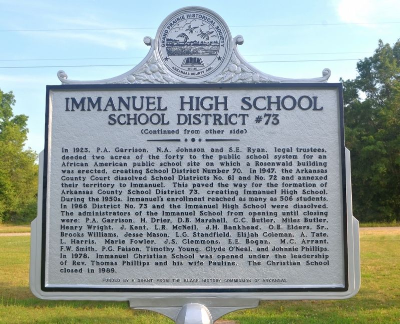
The Immanuel Industrial Institute, a rural boarding school, was established in 1910 by the White River District Association of Missionary Baptist Churches to educate the African American children of the White River District. The first building was . . . — — Map (db m225240) HM
When Napoleon I became Emperor of France in 1799, he envisioned the establishment of a vast "French Empire in America". He began in 1800 when he won control of Louisiana from Spain.
Constant threat of war with England soon forced him to . . . — — Map (db m108650) HM
This Stone Was Taken
from
Ruins of Old Bank, built
at
Arkansas Post, 1839.
Arkansas Post State Park.
Created by Act of Legislature 1929.
Introduced by Ballard Deane,
Representative, Arkansas County.
Act . . . — — Map (db m108550) HM
The land passed from France to the United States in 1803 with the Louisiana Purchase. Arkansas then became a territory on March 2, 1819: the Post of Arkansas was designated its capital.
The Territorial Secretary Robert Crittendon, acting in . . . — — Map (db m108651) HM
The United States and several European powers vied for control of the lower Mississippi Valley. Arkansas Post was the key to that control.
In 1541 Hernando de Soto explored the territory which is now Arkansas. Sieur de La Salle further . . . — — Map (db m108647) HM
The Regent of France authorized a settlement at the Post of Arkansas in 1722. These early settlers were on good terms with the Quapaw Indians who "exhibited a great spirit of friendliness and hospitality toward the French". Cotton was introduced . . . — — Map (db m108648) HM
Here on the Grand Prairie you tread on
soil laid down over the centuries as the
mighty Mississippi and Arkansas Rivers
brought down their precious cargoes of
silt from the northern uplands.
The footprints of many were pressed into
this . . . — — Map (db m108486) HM
In 1763 the Post of Arkansas became
Spanish territory when, by the Treaty of
Paris, the French King ceded Louisiana
to Spain. For several years after the
transfer, French officers and soldiers
remained at Arkansas Post.
In 1771 the . . . — — Map (db m108551) HM
A bitter winter rain had turned the ground to mud. But the Confederate
soldiers had to keep digging. These rifle pits, lying just a few feet from where
you stand, were far from finished. Though exhausted and hungry, the soldiers
were ordered to . . . — — Map (db m107874) HM
The Confederate scouts were alarmed. Looking down river to your right, one exclaimed, "One could hardly see anything in the background but smokestacks."
Union soldiers disembarked from their transports. All night, knee deep in mud, they . . . — — Map (db m108509) HM
You wouldn't have got us had it not been for your damned gunboats.
John Dunnington, colonel, chief of ordnance
Fort Hindman's cannon fired at the nine gunboats
bearing down on them. Confederate gunners had . . . — — Map (db m108072) HM
Half the Yankees in the West [were coming].
Confederate scout
I expected Mary would be a widow before I got 10 rods [55 yards]. . . . — — Map (db m107858) HM
In the early 1800's the land in front of you was an important
center of trade and government on the edge of the Arkansas River
wilderness. Here were the homes, stores, taverns, mills,
docks, and busy streets of the Post of Arkansas. This . . . — — Map (db m108428) HM
The succession of outposts here, remote from centers of New
World empire, symbolized a dream of the imperial age: to
connect the Gulf of Mexico to North America's vast interior
by the great rivers that drained it.
Following British . . . — — Map (db m108485) HM
Spanish Explorer Hernan de Soto passed this way in 1542. Nearly
130 years later Father Marquette, the French missionary and explorer,
reached the nearby mouth of the Arkansas. In 1682 Robert Cavelier,
Sieur de la Salle, claimed this territory for . . . — — Map (db m108407) HM
Arkansas Post was not a single fort and trading center. From
1686 until 1863 there were no fewer than seven posts on the
Arkansas River between here and the Missişsippi. The flags
of five nations flew over them.
The 1686 post . . . — — Map (db m108464) HM
During the American Revolution, Arkansas Post
belonged to the Spanish, allies of the American
patriots. In 1783, British partisans led by James
Colbert raided the Spanish village and fort here.
It was one of the last engagements of the . . . — — Map (db m108483) HM
Standing here in January 1863, you would have seen
Confederate Fort Hindman. In what is now the water, the
fort stood atop a 25-foot high bluff The fort's cannon could
fire a mile up or down the river to protect the breadbasket
of Arkansas. The . . . — — Map (db m108511) HM
Bayou Meto Cemetery was established in 1876 after Allen "Uncle Gip" Gibson donated one acre of land to the local community for use as a cemetery. Gibson, a former Union soldier, was an early settler of the Bayou Meto Community. A skilled . . . — — Map (db m178029) HM
Listed in the Arkansas Register of Historic Places in 2003, the Bayou Meto Schoolhouse is one of the last remaining historic school buildings in the area. The first Bayou Meto school was established in 1875, within the Pampas School District. It . . . — — Map (db m178030) HM
Thirteen charter members founded Mount Zion Methodist Episcopal Church South in 1881 and constructed a small, wooden church building in the southwest corner of the Bayou Meto Cemetery. The structure contained handmade pews, oil lamps, and
a wood . . . — — Map (db m178026) HM
On this site from September 1862 to January 1863 was the encampment of a celebrated Texas cavalry company. Captain Alf Johnson's Spy company was active in conducting reconnaissance and small unit actions near Helena while maintaining vigilance on . . . — — Map (db m107804) HM
Named for Captain Robert Crockett, grandson of the famous David (Davey) Crockett, this community was a flourishing river port during the second half of the 19th century. The Crockett Rifles (Company H, 1st Arkansas Infantry), first Confederate . . . — — Map (db m107807) HM
Named for resident William Finley Crockett, son of frontiersman Davy Crockett, this community was once a flourishing river port during the second half of the 19th century and into the early years of the 20th century. Steamboats loaded with cotton, . . . — — Map (db m201389) HM
From the 19th century to present day, the economy of Arkansas County has been based on agriculture, especially rice farming. An essential part of rice farming
is having enough water at the right time to flood the fields. Natural water sources . . . — — Map (db m192660) HM
On January 9, 1863, Gen. John McClernand and Adm. David D. Porter led a 30,000 man army and a flotilla of Union gunboats up the Arkansas River to confront Gen. T.J. Churchill's 5,000 Confederates at Arkansas Post. The gunboats bombarded Fort Hindman . . . — — Map (db m107701) HM
Here on June 17, 1862 a Federal fleet of eight vessels attempted to force its way upstream past Confederate shore defenses commanded by Captain Joseph Fry. The Confederates disabled the Union gunboat Mound City with heavy casualties before . . . — — Map (db m107918) HM
J. Deane and Son was a hardware store that
served this area beginning in 1890. During the
steamboat era, St. Charles was a thriving river
boat community and this was its largest retail
outlet.
Founded by Joe Deane, who arrived here . . . — — Map (db m108563) HM
[Northeast face]
Officers and men killed on
the U.S.S. Mound City
{List of 124 dead}
[Northwest face]
Near this spot, on June 17, 1862,
a decisive engagement was
fought between the Conf-
ederates entrenched and
the . . . — — Map (db m108071) WM
In August and September, 1862, General Mosby M. Parsons
and 800 men of the Missouri State Guard encamped here,
after a perilous crossing of the Mississippi River into Desha
County. This small force of infantry and artillery blocked
enemy . . . — — Map (db m167369) HM
Named for educator Leroy Davis Holman, North Carolina-born educator who began teaching Stuttgart’s African American children in 1907. The school, first located at Porter and Lincoln Streets, was rebuilt in 1924 with Rosenwald Foundation funding. . . . — — Map (db m201392) HM
Rev. Adam Buerkle brought a
colony of German Lutherans to
this area in 1878. In 1880 he named the post office
Stuttgart in honor of his native city. Stuttgart was
platted in 1884 and incorporated in 1889. Col. Bob Crockett,
a grandson of Davy . . . — — Map (db m191876) HM
The citzens at this time paused and reflected on those pioneers who with sweat and tears gave this community its heritage and traditions. This memorial recognizes the dedication and efforts of all those who made this centennial a year to remember . . . — — Map (db m167630) HM
Green Grove Cemetery got its official beginning when Martin and Minnie Buerkle sold two acres of property to the Trustees of Green Grove Cemetery Association in September of 1903. This cemetery was likely the first burial ground dedicated to serving . . . — — Map (db m234960) HM
Ashley County in the Civil War
Thirteen companies were raised and organized in Ashley County for Confederate service during the Civil War: Co. F, 2nd Arkansas Cavalry; Cos. A, B, K and L, 3rd Arkansas Infantry; Co. F, 8th Arkansas Infantry . . . — — Map (db m107691) HM
World War I
Dedicated
to the sons of
Ashley County
Arkansas
Who Made The Supreme Sacrifice
For Humanities Defense
in the World War
1914 — 1918
_______
{List of the honored . . . — — Map (db m108565) WM
The Mountain Home Cemetery began with the burial of an 11-month-old child, Willie Russell, in 1857. Willie was the son of County Judge John S. Russell. The lot was owned by Orrin L. Dodd, known as the “Father of Mountain Home,” before it was . . . — — Map (db m243005) HM
This commercial historic district was added to the
National Register of Historic Places on June 15, 2010
as a representative collection of early to mid-20th
century vernacular architecture, Centered on the
Baxter County Courthouse, which was . . . — — Map (db m170753) HM
About 1800 near this spot white man established the first trail from East to West across Baxter County. Later some of the Cherokee Indians were moved to Oklahoma using this route which was known as the Trail of Tears. — — Map (db m62248) HM
On Oct. 12, 1862, Maj. John Wilber led a force of 125 men of the 14th Missouri State Militia (U.S.) and 100 from the Enrolled Militia from Ozark, Mo., to hit Confederate troops camped at Yellville. High water on the White River forced the Union . . . — — Map (db m170457) HM
In 1829, when Arkansas was a territory of the United States, Jacob Wolf
donated the land and built this structure as the first permanent courthouse for
Izard County. Great competition existed among frontier settlers to secure the "seat of justice . . . — — Map (db m170827) HM
Courthouse
Jacob Welt was serving as a legislator in the Arkansas Territorial General
Assembly in 1829 when he wrote the legislation to create the structure you see as the country's first permanent courthouse. In the legislation he noted . . . — — Map (db m171518) HM
Wolf Family Home
Even after the county seat moved, this house bustled with activity.
Arkansas became a state in 1836, and settlers followed the White River
hundreds of miles into the interior of north Arkansas. Thousands of these
settlers . . . — — Map (db m171528) HM
Jacob Wolf was a merchant, builder of log structures,
carpenter, and blacksmith. He was elected a
representative to Arkansas Territory's General
Assembly in 1826. The two-story dogtrot structure
constructed by Wolf in 1829 served as Izard . . . — — Map (db m170758) HM
Here on February 17, 1862, Brig. Gen. Rains with the Fourth Arkansas Regiment and the Third Louisiana, ambushed the advance of the Federal army under Brig. Gen. Curtis killing 20 of his men and some 60 horses in his advancing cavalry. The . . . — — Map (db m99707) HM
800 AD • Trace of the Rock People
1808 • Osage Boundary
1815 • Lawrence County
1827-28 • Lovely County
1838 • Trail of Tears
1840 • Trott's Stand
1858 • Old Wire Road
1858-61 • Butterfield Stage Route
1861 • Troop Trails
1862 • . . . — — Map (db m62485) HM
The Distinguished Service Cross (Army), Navy Cross, and Air Force Cross are equivalent awards. They are given to any service person who, while serving, distinguishes himself or herself by extraordinary heroism not justifying the award of the Medal . . . — — Map (db m90867) HM WM
This native stone tank was built in 1927 by the Linebarger brothers, under the supervision of Willard Braithwaite, to store water for summer cottages on the west side of Lake Bella Vista and later the Sunset Hotel. From 1927 to 1952, water from the . . . — — Map (db m224956) HM
The Bronze Star Medal is awarded to any person who, while serving in any capacity in or with the military of the United States after 6 December 1941 distinguished himself or herself by heroic or meritorious service or achievement, not involving . . . — — Map (db m90855) HM
The Cold War was a period of East-West competition, tension, and conflict short of full-scale war. It was characterized by mutual perceptions of hostile intention between military-political alliances or blocs. Quoting from a Veterans of Foreign . . . — — Map (db m92218) HM WM
A bronze patee on which is superimposed a four-bladed propeller, the Distinguished Flying Cross is awarded to any person who, while serving in any capacity with the Armed Forces of the United States distinguishes himself or herself by heroism or . . . — — Map (db m90865) HM
So called because steps were dug into the hill so settlers could reach the top.
Once existed two churches, a school and a cemetery. Area named and cemetery started about 1867. — — Map (db m90572) HM
On June 25, 1950, North Korean troops started the Korean War by invading South Korea. Two days later, the United Nations Security Council adopted a resolution calling member nations to help defend South Korea. In all, 16 nations sent troops to . . . — — Map (db m92219) HM WM
The Legion of Merit was the first American decoration awarded to citizens of Foreign Nations. There are four degrees of award. They are Chief Commander, Commander, Officer, and Legionaire/Legion of Merit. Only the Legion of Merit is awarded to . . . — — Map (db m90866) HM
The Lewis & Clark Expedition was accomplished by Captain Meriwether Lewis, Captain William Clark, and their fellow explorers, and was the visionary journey of President Thomas Jefferson. The journey was to become one of America’s greatest . . . — — Map (db m91477) HM
The Medal of Honor is the highest Military decoration awarded by the United States. It is bestowed on a member of the American Armed Forces, who distinguishes himself or herself conspicuously by gallantry and intrepidity at the risk of his life . . . — — Map (db m90869) HM WM
War with Mexico was the result of the annexation of the Republic of Texas to the United States in March 1845, which the Mexican government regarded as an act of war since they had refused to recognize Texas' independence. Following the capture of . . . — — Map (db m91501) HM WM
After Iraq's defeat in the Persian Gulf War, the Iraqi dictator ignored numerous United Nations Resolutions which resulted in America declaring a "regime change" as an official goal of U.S. policy. In the context of the new terrorist threat after . . . — — Map (db m92337) HM WM
In 1961 and again in 1973, Iraq had claimed that the nation of Kuwait was part of Iraq. On August 2, 1990, Iraq troops invaded the disputed area claimed by Kuwait. Iraqi invaders looted Kuwait, then headed toward Saudi Arabia. For several months, . . . — — Map (db m92241) HM WM
In 1782 General George Washington created a new military badge for Enlisted Men and Non-Commissioned Officers called the Badge of Military Merit. This was the forerunner of the Purple Heart that we know today. The award fell into disuse until . . . — — Map (db m90776) HM WM
The American Revolution was a conflict between England and thirteen of her colonies in North America. Following years of taxation, suppression, and subjugation by the British, fighting began at Lexington and Concord, Massachusetts in 1775. A scant . . . — — Map (db m91470) HM
Criteria: The Silver Star Medal is awarded to any person who, while serving in any capacity with the Armed Forces of the United States is cited for gallantry in action while engaged in military operations involving conflict with an opposing armed . . . — — Map (db m90778) HM WM
Any discussion of the Battle of the Alamo must begin with the Siege of Bexar, named after San Antonio de Bexar which ocurred [sic] in December 1835. In early December, Bexar was controlled by the Mexicans. On December 5th, a group of Texas . . . — — Map (db m91496) HM WM
SACRIFICE:
In 1939 the active United States military totaled 335,000, and during the conflict more than 16 million men and women had served. Tens of millions of men and women throughout the world were in military service in other nations of . . . — — Map (db m91985) HM
The immediate cause of the War Between the States was the election of Abraham Lincoln to the Presidency of the United States in 1860. The deeper cause, however, was the issue of states' rights. The question of states' rights was based on the . . . — — Map (db m91678) HM
The devastating September 11, 2001, attacks on American soil rattled the nation's morale as it became clear the Al Qaeda terrorists sought nothing less than the destruction of the United States of America.
Leaders of Al Qaeda had taken refuge in . . . — — Map (db m92258) HM WM
The periods from the end of World War I to 1929 could be accurately described as 'boom to bust'. Great new technologies such as the family automobile, talking pictures, radio, and commercial air service were being woven into American lives. . . . — — Map (db m91952) HM
Following World War I, the United States remained isolated from world affairs as economic and political factors led to the rise of nationalistic powers in the Soviet Union, Germany, Italy, and Japan. A series of bold moves by Germany and weak . . . — — Map (db m91954) HM
Our Constitution names the President of the United States the Commander in Chief of all the Armed Forces. Presidents who have served in our military are displayed on the following plaques. Each has served either on Active Duty, in the National . . . — — Map (db m92382) HM WM
[Written on the initial marker, provided for context]
Our Constitution names the President of the United States the Commander in Chief of all the Armed Forces. Presidents who have served in our military are displayed on the following . . . — — Map (db m92384) HM WM
[Written on the initial marker, provided for context]
Our Constitution names the President of the United States the Commander in Chief of all the Armed Forces. Presidents who have served in our military are displayed on the following . . . — — Map (db m92389) HM WM
[Written on the initial marker, provided for context]
Our Constitution names the President of the United States the Commander in Chief of all the Armed Forces. Presidents who have served in our military are displayed on the following . . . — — Map (db m92400) HM WM
[Written on the initial marker, provided for context]
Our Constitution names the President of the United States the Commander in Chief of all the Armed Forces. Presidents who have served in our military are displayed on the following . . . — — Map (db m92421) HM WM
[Written on the initial marker, provided for context]
Our Constitution names the President of the United States the Commander in Chief of all the Armed Forces. Presidents who have served in our military are displayed on the following . . . — — Map (db m92423) HM WM
[Written on the initial marker, provided for context]
Our Constitution names the President of the United States the Commander in Chief of all the Armed Forces. Presidents who have served in our military are displayed on the following . . . — — Map (db m92424) HM WM
Founder’s Statement
All Who Serve Sacrifice
Some Who Serve Sacrifice All
Welcome to the Veterans Wall of Honor, honoring all veterans of our Armed Forces who have served in peace and war since the Revolutionary War. In the spring of 2001 . . . — — Map (db m92585) WM
The Japanese attack on our military installations in Hawaii was only one of a series of victories in late 1941 and early 1942 gained by them. By the summer of 1942 Japan controlled huge portions of Asia and the Pacific. Fortunately for the United . . . — — Map (db m91992) HM
The 1954 Geneva Accords temporarily divided Vietnam into Communist-controlled North Vietnam and nationalist-controlled South Vietnam. Three years later South Vietnamese Communists, called Vietcong, began rebelling. To try to halt the spread of . . . — — Map (db m92239) HM WM
Still reeling from the loss of its North American colonies and fighting in a European war, England began to stop and search American ships on the high seas. During such searches, American sailors would be impressed against their will into the . . . — — Map (db m91478) HM
The paradox of power is that a weaker nation will seek help from a stronger nation to resolve a problem, then hate the stronger nation because the weaker nation could not solve the problem themselves.
Though it was not realized at the time, . . . — — Map (db m92254) HM WM
There were two principal causes for the war with Spain. The first was the brutality of the methods by which the Spanish Colonial authorities sought to suppress the revolution that began in Cuba in 1859 - methods that outraged the American sense of . . . — — Map (db m91849) HM
During the war more than 300,000 women would join the armed forces, many helping to free men to fight on the battlefronts. They served in both the European and Pacific Theaters of Operation as clerks, radio operators, mechanics, ferry pilots, and, . . . — — Map (db m91956) HM
'The war to end all wars' began following the assassination of the Archduke of Austria-Hungary in the summer of 1914. Before the summer was over Great Britain, France, Russia, and their allies were at war with Germany, Austria-Hungary, and their . . . — — Map (db m91850) HM
Following the sneak attack on Pearl Harbor on December 7, 1941, the massive American production might was mobilized. After that attack the production of most non-essential consumer goods was halted or curtailed, and manufacturing facilities were . . . — — Map (db m92187) HM
Headquarters & Headquarters Battery
1st Battalion
142nd Field Artillery
November 21, 1990 - September 17, 1991
In honor of those who served in Operation Desert Shield and Operation Desert Storm — — Map (db m242844) WM
The first court house in Benton County, built of hewed logs was erected on this site (at Bentonville) in 1837, the year after the county was created. It was named for Thomas H Benton. — — Map (db m19880) HM
Benton County Hardware, circa 1893, W.J. Doke proprietor. First Motor Co. and first gas station in alley beside store. Recently housed Bentonville Furniture. — — Map (db m54310) HM
To insure protection during its lifetime, owner Bill Bradford on April 11, 1975, legally willed to itself this tree and all land within a radius of 10 feet from its trunk and donated its use to the city of Bentonville as a mini-park in celebration . . . — — Map (db m50368) HM
Named for Alexander H. Stephens, vice-president of the Confederacy, it covered land on Little Sugar and Brush Creeks extending eastward three miles from their confluence at this point.
Brig. Gen. Nicholas Bart Pearce established it in July, 1861 . . . — — Map (db m225100) HM
Col. Samuel W. Peel House
Built 1876
has been placed on the
National Register
of Historic Places
by the United States
Department of the Interior
— — Map (db m167937) HM
All 4 sides
Confederate
Side 1
To the Southern Soldiers
Side 2
Their names are borne on honor's shield.
Their record is with God.
Side 3
They fought for home and fatherland.
Side . . . — — Map (db m21242) HM
The word "Usonian" was derived from an abbreviation of "United States of North America." Frank Lloyd Wright embraced this term as the name for a distinct American and democratic style of residential architecture he developed during the Great . . . — — Map (db m108874) HM
On the morning of March 6, 1862, Gen. Franz Sigel was eating his breakfast at the Eagle Hotel which stood on this site. He had remained here with 600 men and a battery of six pieces after the main column of his army had passed through Bentonville on . . . — — Map (db m22447) HM
"Everything that's ever going to be of use to you—in architecture or in life or anywhere you go or whatever you do—is going to be nature."
Frank Lloyd Wright
Frank Lloyd Wright (1867-1959) lived during a period of rapid . . . — — Map (db m108873) HM
1713 entries matched your criteria. The first 100 are listed above. Next 100 ⊳