When Methodism first came to this area in the late 18th century, residents worshipped in local homes and journeyed to nearby towns to attend services. On November 20, 1848 William and Sarah Griffith conveyed land at this location to Trustees of the . . . — — Map (db m38620) HM
The origin of this community can be traced to the mid-18th century, when growing travel between Dover and the head of the Chester River resulted in the establishment of a Public House here to support the needs of travelers. Increasing commerce led . . . — — Map (db m39052) HM
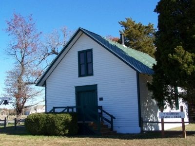
Roby United Methodist Church-First settled in the 18th century, the town of Leipsic quickly became a center for maritime commerce. In 1831, residents of this growing community established the Leipsic Methodist Episcopal Church. Increasing political . . . — — Map (db m141316) HM
Little Creek United Methodist was established in 1820 as Gum Swamp Methodist Episcopal. By 1832 the church operated and maintained a non-segregated school. In February 1875 the congregation relocated Gum Swamp ME to its current site and on May 30, . . . — — Map (db m141374) HM
Stone is a rare material on this coastal plain, so when you find three stone buildings in one small area, there has to be a reason. The reason is that the same person, Manlove Hayes, built them all. Hayes built the house now known as the Stone . . . — — Map (db m50628) HM
The Town of Little Creek developed in the early 1800s as a wharf on the Little River between two neighboring plantations. Originally known as Little Landing, the community began as a trading and shipping hub for salt marsh hay, agricultural products . . . — — Map (db m141378) HM
Quakers were gathering for worship in this area by 1712, when members of the Religious Society of Friends met "at the widow Needham's at Murderkill Creek." Established as Motherkiln Preparative Meeting (under the care of Duck Creek Meeting), the . . . — — Map (db m39459) HM
A native of Virginia's Eastern Shore, Mifflin came to Delaware as a young man. Born into a slaveholding Quaker family, he manumitted his own slaves in 1774-75 and later became one of America's foremost abolitionists of the 18th century. As an elder . . . — — Map (db m39456) HM
Responsible for marking the boundaries of Maryland and Pennsylvania (including the "Three Lower Counties" of Delaware), Mason and Dixon began their survey of the North-South or Tangent Line at the southwestern corner of present-day Delaware in June . . . — — Map (db m168146) HM
The site of one of the earliest Methodist Churches in America, the first structure was built in 1761 as an Episcopal Church. Built of logs, the church was referred to as the Log or Forest Chapel. According to tradition, ownership of the structure . . . — — Map (db m138266) HM
Originally part of St. Jones Hundred, renamed Dover Hundred 1823, the boundaries being Little Creek on the north and St. Jones Creek on the south, extending from Delaware River to Maryland Line. Dover Hundred was divided 1877 into two Hundreds, . . . — — Map (db m74137) HM
It is believed that parishioners of Bethel African Methodist Episcopal Church were worshiping in a private residence on North Street by 1859. The church eventually moved to a site on Church Street to accommodate the growing congregation. On March 2, . . . — — Map (db m69034) HM
Christ Church Mispillion was the second parish in Delaware established by the Society for the Propagation of the Gospel in Foreign Parts. The Rev. Thomas Crawford first held services of the Church of England in lower Kent County in 1704. The . . . — — Map (db m69033) HM
Colonel John Haslet-A native of Ulster, Ireland, John Haslet was born circa 1728 and emigrated to America about 1757. After playing an active role in the Pennsylvania militia during the French and Indian War, Haslet eventually settled in the Milford . . . — — Map (db m142542) HM
History of Goat Island
This nine-acre island was created in 1927 when the Army Corps of Engineers dug a channel removing the oxbow and straighten the river. At that time, shipbuilding and agriculture were important industries in Milford and . . . — — Map (db m198913) HM
In memory of Joseph Oliver who departed this life February 28, twenty minutes after seven in the morning in the Year of our Lord 1807 aged about eighty years.
Joseph Oliver was owner of land North of the Mispillion River, formally known as Saw . . . — — Map (db m41882) HM
This American Liberty Elm was named after “The Liberty Tree", our country’s first symbol of freedom. On the morning of August 14, 1765, the people of Boston awakened to discover their stamp collector hung in effigy suspended from a giant elm. A few . . . — — Map (db m227857) HM
Town laid out by Joseph Oliver 1787. Village was located on tract then called “Saw-Mill Range.” Named Milford from fording place near mill-dam erected by Rev. Sydenham Thorne across Mispillion Creek, 1787. First incorporated 1807. Old town in Kent . . . — — Map (db m36909) HM
Town laid out by Joseph Oliver 1787. Village was located on tract then called “Saw-Mill Range.” Named Milford from fording place near mill-dam erected by Rev. Sydenham Thorne across Mispillion Creek, 1787. First incorporated 1807. Old town in Kent . . . — — Map (db m36950) HM
Milford Parks and Recreation Director, Gary L. Emory, sits on the bank of Goat Island in the Mispillion River (1981). In the background the newly constructed Milford Police Department can be seen. Goat Island was the first parcel of land acquired by . . . — — Map (db m198909) HM
Milford honors her
men and women who
have served in the
Armed Forces of the
United States in
all wars
In memory of
the founders, builders
and defenders of
our home town
In memory of
Thomas G. Hanley
for . . . — — Map (db m142551) WM
The metal observation tower at Big Stone Beach was one of five constructed in Delaware between World Wars I and II to reinforce nearby Fort Saulsbury. These towers formed an integral part of the fort’s fire control system. Built from metal and . . . — — Map (db m142612) HM
This historic building lies within a 1,750
acre Duke of York land patent called Saw Mill
Range granted to Henry Bowman in 1680. The
first known resident of this portion of the
tract was Joseph Booth, who purchased 510
acres from the Bowman . . . — — Map (db m37393) HM
The beginning of Methodism in this community
can be traced to the organization of a local
“society” in 1777. Early meetings were held
in the homes of its members. On December 3, 1787,
Joseph Oliver conveyed a lot of ground at . . . — — Map (db m36888) HM
On this site stood the home of General Alfred T. A. Torbert who served his country in the War Between the States and later as Consul General at Paris. The building was erected circa 1825 by Benjamin Wadhams for a tavern and later was remodeled for a . . . — — Map (db m142578) HM
Organized on July 18, 1781, the "Baptist Church at Mount Moriah" also called Cow Marsh Baptist Church, is the fourth Primitive Baptist congregation formally constituted in Delaware. For many years members met in area homes. In 1793, Job Meredith . . . — — Map (db m113687) HM
In 1924, the members of the David C. Harrison American Legion Post # 14 initiated the first American Legion ambulance service in the world. Its eighteen founding members were veterans of World War I who volunteered their time to transport the . . . — — Map (db m39026) HM
In 1924, the David C. Harrison American Legion Post #14 in Smyrna formed the first American Legion Ambulance Service in the world. The 18 founding members were veterans of World War I who volunteered to transport sick and injured community members . . . — — Map (db m174556) HM
In 1706 John Allee, of a Huguenot family, bought a
600-acre tract, "Woodstock Bower," of which this land
is a part. One of his sons, Abraham, was prominent in
Kent County affairs until his death in 1776: Member
of the General Assembly 1726, . . . — — Map (db m39589) HM
The history of Citizens Hose Company No.1, Inc. began on January 6, 1886, when thirty residents of Smyrna voted to "go into permanent organization" to serve the firefighting needs of the community. Their charter was approved by the Delaware . . . — — Map (db m141288) HM
Born 1768, near this site. Commanded U.S. Sloop Wasp in notable victory over superior British sloop Frolic, October, 1812, off Cape Hatteras. Commanded frigate Constitution 1818-1829. Died August, 1850. Buried at Cecilton, Maryland. Reinterred in . . . — — Map (db m39031) HM
Grey M. Budd •
† James E. Brown •
† John W. Shallengerger •
† C. E. Dick Burris •
† Daniel D. Jenkins •
† John D. Heverin, Jr. •
† Thomas H. Pearce •
† Walter L. Marryat •
† Roy W. Jones •
† William Billy Rohman •
† David W. . . . — — Map (db m130456) WM
Whitehall Plantation, once owned by the Chew family, contained over 400 acres of land and was worked solely by enslaved labor. Among those enslaved was Richard Allen who was born here and later founded the African Methodist Episcopal Church. By 1798 . . . — — Map (db m142525) HM
For many years this home was the property of Colonel Allen McLane, statesman and hero of the American Revolution.
Born in Philadelphia August 8, 1746, McLane had moved to Delaware by 1769. His military career began when he was commissioned . . . — — Map (db m39028) HM
Major Allen McLane of the village of Duck Creek Crossroads, now known as Smyrna, Delaware, was one of Delaware's most significant heroes of the American Revolution.
McLane volunteered for service in Virginia at the start of the revolution, and . . . — — Map (db m174546) HM WM
In memory of
those who perished
December 7th, 1941
"A date which will live in infamy"
Never again
will one generation of veterans
abandon another — — Map (db m174542) WM
In 1829 the Delaware General Assembly enacted legislation resulting in the establishment of a public school system. The state was subdivided into local districts. One of these was School District #5, which was created to serve the needs of students . . . — — Map (db m142499) HM
Born December 17, 1841, John B. Maberry was the son of John and Temperance Brockson Maberry of Duck Creek Hundred. Responding to the call of his country, he enlisted in the Union Army’s Company F, First Regiment, Delaware Infantry Volunteers, in . . . — — Map (db m39024) HM
In 1733 a charter was granted to “a dissenting congregation” of Scots and Irish Presbyterians who had settled in this area. A Meeting House was subsequently erected at this location. The Reverend Thomas Evans conducted the first service . . . — — Map (db m39032) HM
In 1764, Thomas Green sold a one-quarter acre lot at this location to his grandson, Charles Green. Some time thereafter, Charles established a facility for the manufacturing of redware pottery on this site. The business is known to have been in . . . — — Map (db m39678) HM
The roots of Methodism in this community can be traced to the organization of a local “society” in the 1770’s. Meetings were held in private homes before a frame structure was built here circa 1786 on land provided by Col. Allan McLane, . . . — — Map (db m39027) HM
The first religious organization to hold services in Duck Creek Hundred - 1705. Property transferred to Duck Creek Historical Society - 1962. Michael Desmond, Jr's Eagle Scout Restoration Project - 2002. — — Map (db m39711) HM
In the spring of 1869, the Commissioners of Smyrna approved a plan to erect a Town Hall. Responding to the long-held desire of the citizens for a venue for public gatherings, architect Richard Mitchell designed the building to include a . . . — — Map (db m39030) HM
Founded in 1740, St. Peter's was originally located near Duck Creek on the old King's Highway. In 1762 the congregation moved to a newly constructed stone chapel on the site of St. Peter's Cemetery. When the chapel fell into disrepair, the . . . — — Map (db m141377) HM
This longtime Smyrna landmark was constructed by Robert Holliday in the late 18th century. The first known residents of the home are believed to have been the family of his daughter, Susannah Holliday Wilson. The origin of the name “The . . . — — Map (db m39029) HM
The Gray Box Chateau
24 North Main Street
has been placed on the
National Register
of Historic Places
by the United States
Department of the Interior
1764 — — Map (db m174313) HM
The John Cummins Mansion has been placed on the National Register of Historic Places by the United States Department of the Interior May 23, 1980 — — Map (db m174312) HM
In 1919, a new era for education in Delaware was initiated when a statewide effort to replace old and outdated facilities was undertaken. In 1922, the new Smyrna Colored School opened its doors for African-Americans and other persons of color . . . — — Map (db m141287) HM
Thornley
House
circa 1920
has been placed on the
National Register
of Historic Places
by the United States
Department of the Interior
— — Map (db m174551) HM
The name Union Cemetery is derived from the fact that this burial site was created to inter deceased members affiliated with the African-American houses of worship in this area. Originally owned by James and Hester Till, the land for the cemetery . . . — — Map (db m130460) HM
Delaware’s first Jewish farmers, Isaac and Ida Beinoff, settled here in 1897. Like those to follow, they were recent immigrants fleeing poverty and oppression in their native Russia. Between 1912 and 1929, the Jewish Agriculture Society, based in . . . — — Map (db m142529) HM
Formerly part of Murderkill Hundred, originally called Motherkill Hundred, kill meaning creek in Dutch. Original boundaries were St. Jones Creek on north, and Murderkill Creek on south, extending from Delaware River to Maryland line. In 1867, . . . — — Map (db m51113) HM
Samuel D. Burris, a free African-American conductor on the Underground Railroad resided in the Willow Grove area during the 1840s. He helped enslaved people find their pathway to freedom in Philadelphia. Caught for aiding and abetting runaway slaves . . . — — Map (db m142503) HM
State Consolidated District No. 1 was authorized and created on July 1, 1915. Seven months later on February 28, 1916, voters of the district approved the request of the State Board of Education by a vote of 52 to 1 to bond together schools in the . . . — — Map (db m94381) HM
Efforts to establish rail transportation in Delaware were realized in 1832 with the completion of the New Castle and Frenchtown Railroad connecting shipping traffic on the Chesapeake Bay and Delaware River. The promise of railroads was clearly . . . — — Map (db m39604) HM
The construction of the Delaware Railroad in the 1850s led to the establishment of the Delmarva Peninsula’s first and most important north-south railway transportation artery. Proximity to the nearby community of Camden resulted in the location of a . . . — — Map (db m39603) HM
In 1677, John Grubb (1652-1708) came from Stoke Climsland, Cornwall and settled on the Delaware River at "Grubb's Landing." He was one of the first Englishmen in Delaware.
John and his wife Frances raised nine children: Emanuel Grubb . . . — — Map (db m144195) HM
The Harvey Farm was purchased in 1922 to become the Village of Ardentown. In 1931, the barn, believed to have been built in the 1890s, was converted into the Robin Hood Theatre, a professional summer theater. Film and stage actors including Barbara . . . — — Map (db m239625) HM
Arden is an intentional community, founded in 1900 by social reformers Frank Stephens, a sculptor, and Will Price, an architect, to create a society based on Henry George’s Single Tax economics and William Morris’s arts and crafts philosophy. . . . — — Map (db m239057) HM
President Abraham Lincoln delivered the Gettysburg Address on November 19, 1863, at the dedication of the Soldiers' National Cemetery in Gettysburg, Pennsylvania, an early national cemetery for the Civil War dead. Starting in 1909, a date . . . — — Map (db m184904) HM WM
Named for James Boswell who was born in 1740 in Edinburgh, Scotland and was educated at Utrecht and Edinburgh University. Although a lawyer by profession, Boswell traveled widely in Europe and wrote at length of his journeys with skill and wit. The . . . — — Map (db m146784) HM
[Medal of Honor Recipients markers]
Here interred, with full military honors, at dedication services
on October 15, 1989, are inscriptions conveyed from state and
national monuments, symbolically representing those Delawareans
who made . . . — — Map (db m184901) HM WM
Since World War I more than 91,000 American
soldiers[, sailors, airmen, and marines] are unaccounted for.
This unoccupied seat is dedicated to the memory of
[t]hese brave men and women and to the
[s]acrifices each made in serving this . . . — — Map (db m184896) HM WM
Born in Wilmington, Delaware, on January 12, 1919, James P. Connor entered the U.S. Army in January 1941. As a member of the 7th Infantry, 3rd Division, he was a participant in the amphibious landing at Cape Cavalaire in southern France. On August . . . — — Map (db m144315) HM
The African Union Church (AUC) of Christiana Bridge built a wood-framed church on this site in 1819. The AUC was the first incorporated religious group in the country controlled entirely by African Americans. The congregation replaced the structure . . . — — Map (db m243662) HM
John Barbour was born about 1316 and died in 1396. He was a native of Aberdeen, Scotland, a well educated man and for 40 years served as Archdeacon of St. Machar Cathedral.
In the mid 14th century there were no Scottish universities. John . . . — — Map (db m146790) HM
Lums Pond State Park
The pond has existed since 1735 when St. Georges Creek was dammed to power a sawmill. when the Lum family acquired the mill after 1809, they lent their name to the pond. Some twenty years later, Lums Pond provided water . . . — — Map (db m238407) HM
The trail you are standing on is surrounded by clues to this area's history. Some clues are clearly visible. Others are in the ground where you cannot see them. Archaeologists and historians study all these clues along with written records to . . . — — Map (db m227729) HM
Established in 1917 as part of the esteemed General Federation of Women's Clubs, The Blue Rock Community Club (BRCC) provided an important social and service-oriented outlet for women. Beginning with just 11 founding members, the Club became an . . . — — Map (db m94235) HM
Mount Pleasant ME Church formed in 1837 as an outgrowth of local camp meetings. Construction on the simple stone church began in 1838 and a cemetery was established in 1841. In 1893, Mount Pleasant added stained glass windows, a raised pulpit, and . . . — — Map (db m140549) HM
Welcome to the Mount Pleasant Episcopal Cemetery, first established in 1841. There are 110 known graves and several unknown or unmarked graves. Members of both the Methodist Episcopal Church (1841-1960) and the Church of Christ (1961-1996) are . . . — — Map (db m240844) HM WM
Once the summer home of a prosperous Wilmington businessman and his family, the Cauffiel House has changed little since it was built in the late 1920s. The colonial style brick house still looks down to the Delaware River over land that was . . . — — Map (db m227941) HM
The War Years
In 1944 and 1945, William duPont, Jr. hosted three important tennis championships at Bellevue. The events brought national recognition to duPont's role in promoting tennis and to the sports center he created on this estate. . . . — — Map (db m240851) HM
Charles A. "Chazz" Salkin's 35-year career with Delaware State Parks began as Director of the Young Adult Conservation Corps at Bellevue State Park in 1978 and culminated in an unprecedented 21-year tenure as Director of the Delaware Division of . . . — — Map (db m240845) HM
This was one of the first trees sent back to Europe from the New World. Tea made from the roots was given to women during childbirth and was also made into cough medicine. — — Map (db m240846) HM
Tennis Champion and Champion for Tennis
Margaret Osborne was already tennis champion when she married William duPont, Jr. in 1947. She went on to win titles both in this country and Europe, while working in Delaware to advance the game of . . . — — Map (db m240849) HM
On February 12, 1829, the Delaware Legislature passed the “Act for the establishment of free schools.” To meet the educational needs of the area’s youth, local residents formed a committee that purchased a parcel of land from Joseph Orr in 1830 for . . . — — Map (db m80519) HM
The Bellevue Transformation
After inheriting Bellevue from his father in 1928, William duPont, Jr. transformed the estate to reflect his own passions. DuPont was a man who loved his time on horseback and on the tennis court, and Bellevue . . . — — Map (db m240848) HM
Known in its early days as the "Presbyterian Church at Christiana Bridge," this congregation was organized in the 1730s. A church structure was built on this site soon after and a graveyard was established by the mid-18th century. Rev. Charles . . . — — Map (db m145161) HM
Formal education for African American children in Christiana began in the 1880s with the construction of a one-room schoolhouse. Many African American schools in existence at this time were marked by dilapidated facilities, a lack of running water, . . . — — Map (db m145173) HM
The origin of this congregation may be traced to the earliest days of Methodism in America. In March, 1771, Joseph Pilmore, one of the first Methodist missionaries from England, preached outdoors at Christiana. Upon returning in 1773, Pilmore noted . . . — — Map (db m145164) HM
General Lafayette enroute to Virginia, to command expedition against Benedict Arnold, landed 1500 troops here, with cannon, stores, and ammunition, March 2, 1781. Council of Maryland issued warrant to impress carriages, teams and drivers for his use . . . — — Map (db m145051) HM
An Act of the Second Continental Congress established the Delaware Regiment on December 9, 1775. Delawareans were eager to fight for independence from Great Britain, and the regiment quickly grew to over 700 men in 1776. The regiment was initially . . . — — Map (db m145050) HM
In 1813 a group of African-American Methodists led by Peter Spencer formed an independent denomination that came to be known as the African Union Church. It was the first incorporated religious body in the United States controlled entirely by . . . — — Map (db m145162) HM
Operated flour mill one-fourth mile south. Was captain in French and Indian War. In American Revolution was member of Boston Relief Committee, colonel of Delaware battalion of famous "Flying Camp," Brigadier General of Delaware militia and first . . . — — Map (db m67210) HM
Colonel George Talbot , cousin of Lord Baltimore, in defiance of William Penn's claim to Delaware, erected a fort nearby, 1684, on land of the Widow Ogle. Talbot dispossessed settlers between here and Iron Hill who refused to acknowledge Baltimore . . . — — Map (db m145052) HM
Colonial River Port and Crossroads
A National Historic District
1684
[reverse side]
Named for Queen Christina of Sweden
Home of Col. John Read
Landing of Marquis de Lafayette and 1500 Troops. March 1781
Major colonial . . . — — Map (db m145361)
1606 entries matched your criteria. Entries 201 through 300 are listed above. ⊲ Previous 100 — Next 100 ⊳