On 297th Street (State Highway 46) 0.2 miles east of Front Avenue Southeast, on the right when traveling west.
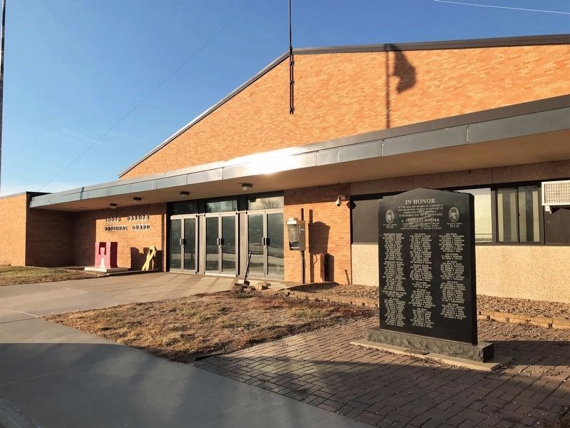
of the men and women of Company A
153rd En Bn who served in support of
Operation Iraqi Freedom II.
07 December 2003 to 01 March 2005
A Company Roster
Commander - CPT Gregory R. Darlow
First Sergeant - 1SG John L. Noyes . . . — — Map (db m217633) WM
On 1st Ave. W at Commercial St., on the right when traveling east on 1st Ave. W.
This Memorial dedicated to all veterans of Clark County and to those who will come after us for their service to God and Country. They gave the supreme sacrifice
Sponsored by American Legion and Veterans of Foreign Wars Posts and . . . — — Map (db m183482) WM
On 1st Avenue East at South Commercial Street, on the left when traveling west on 1st Avenue East.
Samuel H. Elrod was born near Coatesville, Indiana, May 1, 1856. Having worked his way through Asbury College, now Depauw University, graduating in 1882, he passed the Indiana Bar Examinations and headed for Dakota Territory. Arriving in Watertown . . . — — Map (db m183480) HM
On U.S. 212, 0.2 miles west of 433rd Avenue, on the right when traveling east.
In 1931 an economic depression spread across South Dakota and the nation. A drouth ravished crops and unemployment was widespread.
In an effort to raise the morale of the people and to give amateur baseball players an opportunity to compete, . . . — — Map (db m183478) HM
On Lincoln Street south of State Highway 28, on the right when traveling south.
CW2 Scott Saboe
CW2 Scott Saboe was assigned to Alpha Company, 4th Battalion, 101st Aviation Regiment, "The Comancheros." CW2 Saboe took great pride in being an Army aviator and an Assault Helicopter Pilot. His dedication and technical . . . — — Map (db m206436) HM WM
On Lincoln Street south of State Highway 28, on the right when traveling south.
All Gave Some
Some Gave All
Clark County Veterans Who Gave The Ultimate Sacrifice For Our Freedom
World War I
Lyman F Baker ·
Antone Barrie ·
Henry G Chatfield ·
Emery D Cloud ·
Ernest L Cloud ·
Otto H Disrud · . . . — — Map (db m206441) WM
On University Road, 3 miles east of State Highway 19, on the right when traveling north.
The Southeast South Dakota Experiment Farm was organized on April 5th 1956, for the purpose of conducting a research demonstration farm in Southeast South Dakota. It was through the efforts of the Norgren family, farmers, and other interested people . . . — — Map (db m182240) HM
On White Street (469th Avenue) north of Madison Street, on the left when traveling north.
The town that became Burbank began its life in Union County under the name Liberty. In 1873, the town was moved to a new plat on its present location and renamed for territorial governor John A. Burbank. Non-Indians had resided in the Burbank area . . . — — Map (db m221306) HM
On State Highway 50 east of 469th Avenue, on the right when traveling west.
On November 25, 1935, 17 farmers from Clay and Union counties held an historic meeting at the Manning/O'Connor store in Burbank, three miles south of this spot. Their purpose was to form a consumer-owned corporation which would allow the rural . . . — — Map (db m221237) HM
On University Road, 0.5 miles south of 304th Street, on the right when traveling south.
Dalesburg School
The Dalesburg School was located one-half mile south of the village site on land donated by Andrew and Lina Berg in 1872. Classes were held in the Berg home until the schoolhouse was built in 1874. A second building was . . . — — Map (db m221138) HM
On Main Street (State Highway 46) east of Dakota Avenue, on the right when traveling east.
far left:
WWI
McFarland, Carl H. ·
Olsen, Oscar ·
Morman, Henry C.
WWII
Hansen, Duane A. ·
Logan, Leo ·
Oien, Orvin C.
Korean War
Jensen, Roger R. ·
Larsen, Ronald R. ·
Eide, Mervin
Vietnam War
Gerry, . . . — — Map (db m222204) WM
On Main Street south of State Route 50, on the right when traveling east.
Meckling, like so many small American towns, was built by progress, and it was progress that slowly took the town away. The town was named for railroad grading contractor Jonas S. Meckling, who helped to build the Dakota Southern Railway through the . . . — — Map (db m179346) HM
On Main Street south of State Route 50, on the left when traveling east.
Named for a grading contractor on the Dakota Southern Railway, built in 1872. George W. Gilbert became the first postmaster on 29 April 1873. Prior to that Lincoln Post Office, Charles M. Taylor, Postmaster, 27 July 1864 was nearby to the south. In . . . — — Map (db m179347) HM
On South Dakota Route 50, 3 miles west of Interstate 29, on the right when traveling west.
August Bruyer, his wife, Josephine (Simon) and their sons, John and Julius, were born in France, coming to America about the middle of the nineteenth century. By 1858, they had settled in Fairview Township, 4 miles east of what was to be Vermillion. . . . — — Map (db m179897) HM
Near East Cherry Street east of North Dakota Street, on the right when traveling east.
(USD '40)
World War II
Olson, of the U.S. Army Infantry, exhibited extraordinary and repeated personal heroism in the 1943 Italian campaign. After leading his troops in multiple engagements with German forces, he was fatally wounded and . . . — — Map (db m221359) HM WM
Near East Cherry Street east of North Dakota Street, on the right when traveling east.
(USD '39)
World War II
Foss was a U.S. Marine pilot in the Pacific who shot down 23 enemy aircraft and returned home to be elected governor of South Dakota. He was the first commissioner of the American Football League, was president of . . . — — Map (db m221360) HM WM
On West Main Street at High Street, on the right when traveling west on West Main Street.
Dedicated in memory of all who have served and to those who gave their lives in the service of our country in World Wars I & II
Clay County
South Dakota
Rededicated July 4, 1976 our nation's 200th birthday in honor of the Clay County . . . — — Map (db m221604) WM
Near East Cherry Street east of North Dakota Street, on the right when traveling east.
(USD '49) Vietnam War, Korean War, WWII
A U.S. Air Force pilot captured by enemy forces in 1967, Day was recaptured after escaping and was finally repatriated at the end of the war after years of torture and deprivation in prison. Day is one . . . — — Map (db m221357) HM WM
Near South Dakota Street, 1.5 miles south of U.S. 50, on the right when traveling south.
The Missouri River flowed beneath the bluff when Meriwether Lewis and William Clark led the Corps of Discovery on their epic journey. The mouth of the White Stone River was then near this site at Cotton Park. Now known as the Vermillion River, its . . . — — Map (db m179205) HM
On East Main Street west of Church Street, on the right when traveling west.
Vermillion's downtown district moved from below the bluff after the 1881 flood destroyed the original town, forcing development on higher ground. The new business district was located on the north side of Vine (Main) Street. Some of the pre-flood . . . — — Map (db m221597) HM
On State Highway 50 west of 469th Avenue, on the right when traveling east.
On November 25, 1935, 17 farmers from Clay and Union counties held an historic meeting at the Manning/O'Connor store in Burbank, three miles south of this spot. Their purpose was to form a consumer-owned corporation which would allow the rural . . . — — Map (db m179899) HM
On State Highway 19, 0.1 miles north of 312th Street, on the left when traveling north.
Change came slowly to Spirit Mound after 1804. For 55 years the area remained the land of the Yankton Sioux, with fur traders conducting business from posts on the Missouri. The tallgrass prairie continued to thrive as it had for thousands of years . . . — — Map (db m194632) HM
On West Main Street west of South Market Street, on the right when traveling east.
Andrew E. Lee was born near Bergen, Norway, on March 18, 1847. When Lee was four, he and his family moved to Wisconsin. After receiving a general school education, Lee arrived in Vermillion, Dakota Territory, in 1867.
Lee and Charles E. . . . — — Map (db m221599) HM
On South Dakota Street at West Chestnut Street, on the right when traveling south on South Dakota Street.
This stone marks the place where, on the twenty first day of July A.D. 1875, A.L. 5875, the Most Worshipful Grand Lodge, Ancient Free and Accepted Masons of Dakota, was constituted and the officers installed.
Grand Officers
Thos. H. . . . — — Map (db m179206) HM
Near South Dakota Street, 1.5 miles south of State Route 50, on the right when traveling south.
Lewis and Clark
The Lewis and Clark Expedition, officially the Corps of Discovery, was in what is now South Dakota from August 21 to October 14, 1804 and from August 21 to September 4, 1806.
While here they would make numerous . . . — — Map (db m187536) HM
On State Highway 19, 0.1 miles north of 312th Street, on the left when traveling north.
On the hot day of August 25, 1804, captains Lewis and Clark and several of their men walked from the river to explore Spirit Mound. They had heard that little people with deadly arrows inhabited the mound. Although they did not find little people, . . . — — Map (db m194633) HM
On State Highway 19, 0.1 miles north of 312th Street, on the left when traveling north.
The Missouri National Recreational River preserves two splendid segments of the free-flowing, once unpredictable "Big Muddy." These natural-appearing reaches are reminiscent of the river as reported in the journal pages of captains Lewis and Clark . . . — — Map (db m194634) HM
On West Main Street, 1 mile south of State Route 50, on the right when traveling east.
The confluence of the Missouri and Vermillion rivers provided an ideal location for camping, farming, and settling for generations. Yankton Sioux camped below the bluffs in the winter for protection from the harsh winds and moved to the bluffs in . . . — — Map (db m179288) HM
On Canby Street, 1.3 miles south of State Route 50, on the left when traveling west.
Early Vermillion settlers built their homes and businesses below the bluff. The town was susceptible to flooding from the Missouri River, which at that time ran next to the bluff.
The winter of 1880 started early and did not subside until an . . . — — Map (db m179289) HM
On North Plum Street at East Main Street, on the right when traveling north on North Plum Street.
Vermillion's third city park was created in 1923 when Charles E. Prentis donated ten acres of land for that purpose in memory of his late wife. The land was originally part of the A. A. Carpenter homestead, including an apple orchard and nursery, . . . — — Map (db m179293) HM
On State Highway 19, 0.1 miles north of 312th Street, on the left when traveling north.
This trail leads to the summit of Spirit Mound, a sacred site for several Plains Indian tribes. Some tribal members make pilgrimages to Spirit Mound, say prayers on top, and leave offerings. As you approach and walk to the top, please do so . . . — — Map (db m39700) HM
The First Baptist Church
Was built in 1889 and 1925.
The Congregation, organized in
1868, is one of the oldest in
South Dakota. The Church
houses a historic Tracker
Pipe Organ.
Has been placed on the
NATIONAL REGISTER . . . — — Map (db m135986) HM
Near East Clark Street north of North Yale Street, on the right when traveling west.
The University of South Dakota (USD) was Dakota Territory's first university. Proposed during the 1862 legislative assembly, it was originally called the University of Dakota.
Governor Jayne signed the bill in April 1862, but details were not . . . — — Map (db m221453) HM
On South Dakota Street, 1.5 miles south of State Highway 50, on the right when traveling south.
After heavy precipitation in the spring of 1984 averaged between 250 to 300 percent of normal, river levels were higher than normal and the ground was heavily saturated. Record (at the time) rainfall in June caused widespread flooding on the James, . . . — — Map (db m177315) HM
On West Cherry Street, 0.5 miles south of State Route 50, on the left when traveling west.
Vermillion
August 24, 1804, Lewis & Clark camped near the White Stone (Vermillion) River and next day visited Spirit Mound 8 miles north. The military road, Sioux City - Ft. Randall after 1855 provided access, as did steamboats. A. C. Van Meter . . . — — Map (db m179392) HM
Near East Campus Drive west of North Pine Street, on the left when traveling west.
Doc Farber devoted his life to teaching, challenging his students, and improving government at the local, state, national and international levels. Born and raised in Illinois, he came to USD in 1935, served as Chairman of the Department of . . . — — Map (db m221361) HM
On South Dakota Street, 0.1 miles south of East Broadway Street, on the right when traveling south.
Lat 42° 46' 23.0" N
Long 96° 55' 51.0" W
From here the Water Trail follows five miles of the Vermillion River to its confluence with the Missouri River near River Mile 772, then continues down the Missouri nine miles to . . . — — Map (db m221312) HM
On 306th Street east of University Road, on the right when traveling west.
The once thriving community of Dalesburg, a mile and a half north, is now deserted. Created in 1869 and named Dahlsborg for immigrants from Sweden's Dalarna Province, Dalesburg was formally founded in 1892. In its heyday, Dalesburg boasted a . . . — — Map (db m221214) HM
On 306th Street at University Road, on the right when traveling west on 306th Street.
On Midsummer Day, June 24, 1925, William Inberg and Arvid Johnson opened the newly built gas station and repair-business Hub City Garage. The name Hub City was suggested on opening day because the site is equidistant from the surrounding towns. In . . . — — Map (db m221219) HM
On State Highway 19 north of 312th Street, on the left when traveling south.
Spirit Mound was a sacred place to area tribes long before the first settlers arrived here from the east. To the Yankton Sioux, Omaha, Otoes, and other tribes, this was the "mountain of little people."
Indians believed it was "bad medicine" . . . — — Map (db m222055) HM
Near State Highway 19 north of 312th Street, on the left when traveling north.
In 1921 the local DAR chapter had this boulder set atop Spirit Mound with a bronze plaque marking the Lewis & Clark site for posterity. Virgil McDonald, a resident of the farmhouse that stood on the northeastern slope, hauled the two ton monument . . . — — Map (db m222054) HM
Near State Highway 19 north of 312th Street, on the left when traveling north.
When William Clark climbed this "conical hill" in 1804, he concluded, correctly, that it was a natural form, not a human-created mound. Its central core is a bedrock of Niobrara chalk that the continental ice sheet did not erode away. The . . . — — Map (db m222056) HM
Near State Highway 19 north of 312th Street, on the left when traveling north.
On August 25, 1804, several members of the Lewis and Clark Expedition left the river "to visit a High Hill...Supposed to be a place of Deavels...with remarkable large heads...[that] kill all persons who...attemp to approach the . . . — — Map (db m222050) HM
Near State Highway 19 north of 312th Street, on the left when traveling north.
This spot was visited in 1804
by members of the Lewis and Clark Expedition
Placed by Paha Wakan Chapter
Daughters of the American Revolution
1921
Restored by the National Park Service, 2003 — — Map (db m242484) HM
On 2nd Street west of Iowa Street, on the right when traveling east.
The NE 1/4 Sect. 33-95-53 was homesteaded by James R. Madara in 1873. Townsite of Wakonda was acquired by Western Town Lot Company in 1885. In 1902 school district #28, Clay County purchased lots 13 and 14, block 4 to erect a school.
The school . . . — — Map (db m222170) HM
On 2nd Street west of Iowa Street, on the right when traveling east.
In 1883, the Congregational Church of Star Corner was organized in the James Montgomery home located near the intersection of 456 Avenue and 301 Street, northeast of Wakonda. With the coming of the railroad in 1884, they moved to Wakonda serving . . . — — Map (db m222171) HM
On 2nd Street at Iowa Street, on the right when traveling east on 2nd Street.
This memorial is dedicated to the men and women of the armed forces who performed their patriotic duty so we can enjoy the freedoms of democracy
Dedicated Memorial Day, 1995 by Wakonda Community
left:
Aaen Edward WW II ·
Abild . . . — — Map (db m222164) WM
The Dexter Cemetery was started by the early pioneers located in this area in 1899 on land donated by John and Eliza Drake. This was followed by the organization of the United Brethren Church in Christ in 1902 under the supervision of Rev. W.F. . . . — — Map (db m101260) HM
On Main Street south of 2nd Street, on the right when traveling south.
Henry’s Centennial Tree, also known as “The Big Tree,” was planted the same year the town of Henry was established, by David & Lucenda Wiley, in from of their business, Lucenda’s Millinery Shop. The tree’s circumference was 30 ft. and its height . . . — — Map (db m213992) HM
On St. Peter St. NW at Hastings Ave. NW, on the left when traveling east on St. Peter St. NW.
District No. 5 School was the first rural public school in Codington County. At a meeting on June 30, 1879 at the Kranz Hotel, it was decided to build the school for $1,000 or less. The first term was from December 1879 to March 1880, taught by . . . — — Map (db m101265) HM
On Minnesota Avenue south of Saint Joseph Street Northwest, on the right when traveling north.
This Parish was established in 1879, the first Catholic Parish within a radius of one hundred miles. The first Mass celebrated June 24, 1879; Centennial Mass celebrated June 24, 1979. — — Map (db m244138) HM
On Saint Joseph Street east of Dakota Avenue, on the left when traveling east.
Holy Rosary Cemetery of Kranzburg
God bless America and all the souls buried here in this cemetery and especially the veterans who served their country when called upon, so that we may continue to enjoy our freedom. All gave some and . . . — — Map (db m244135) HM WM
On South Dakota Route 20, 1 mile east of 462nd Avenue, on the right when traveling east.
During the Moon of the Harvest (August) in 1773 a band of Sioux were camped on the shore of this lake. We-Wa-Ke, fairest maiden in the camp had given her heart to a brave young warrior, Big Eagle, whose courage on the hunt and in battle far . . . — — Map (db m180984) HM
On 1st Avenue Southeast east of Broadway Street South, on the right when traveling east.
Dedicated to the memory
of the men of the 34th Signal Company
Watertown's own
1929 — 1945
Federalized and sent to Camp Claiborne, Louisiana February 1941
Overseas to Northern Ireland February 1942
Invasion Algiers, North . . . — — Map (db m244157) HM WM
On 5th Avenue North West at Skyline Drive on 5th Avenue North West.
This Marks the Site of Home
of
Governor
Arthur Calvin Mellette
Tenth and Last Governor of Dakota Territory
and First State Governor of South Dakota 1885 - 1893 — — Map (db m169942) HM
On First Avenue SE, 0.1 miles east of Broadway, on the right when traveling east.
An example of Neo-classical architecture with Renaissance exterior elements, the Codington County Courthouse was built by Gray Construction under the direction of architects Freed and Perkins & McWayne. It cost $375,000.00 and was dedicated in June . . . — — Map (db m23930) HM
On 1st Avenue Southeast west of Maple Street Southeast, on the right when traveling east.
East side:
In Memory of Codington County Veterans who Gave their Lives
World War I
1917 — 1918
Ernest G. Aderhold ·
Daniel W. Bannister ·
Donald M. Bannister ·
Clifford O. Bates ·
George Coombes ·
Fred W. Domes · . . . — — Map (db m244155) WM
On 1st Avenue Southeast east of Broadway Street South, on the right when traveling east.
All Gave Some
Some Gave All
Gearhart, Michael E. Marine 16 May 66
Stoltenburg, Mark E. Marine 21 July 66
Langenfeld, Charles T. Navy 17 Apr. 66
Bolhouse, Dean F. Army 2 Jan. 69
Noeldner, Daniel M. Army 6 Mar. 69 . . . — — Map (db m244156) WM
On East Kemp Avenue east of North Maple, on the right when traveling east.
Watertown was platted by the Winona & St. Peter Railroad. The uptown district, consisting of six square blocks, was divided into narrow lots intended mostly for commercial use running parallel to the railroad tracks. Important noncommercial . . . — — Map (db m120097) HM
On 1st Avenue Southeast east of South Broadway, on the right when traveling east.
(north inscription)Spanish-American War 1898 —Battles— Manila, Blockhouse No. 4, La Loma Church, San Francisco Del Monte, Meycauayan, Marilao, Bocaue, Bigaa, Guiguinto, Santa Maria, Santa Ysabel, Malolos, Guiguinto R.R. Bridge, . . . — — Map (db m155121) WM
On 1st Avenue Southeast west of Maple Street Southeast, on the right when traveling east.
West side:
Allen, Ephraim J. ·
Ashton, Perry J. ·
Amy, Oren H. ·
Amshein, Jos. ·
Best, Frederick D. ·
Beardsley, Geo. W. ·
Brenswoltz, Orlando P. ·
Bigelow, Orson T. ·
Bartlett, Geo. E. ·
Butler, Harris O. ·
Brown, . . . — — Map (db m244154) WM
On 1st Avenue Northwest east of 3rd Street Northwest, on the left when traveling east.
Watertown's first city hall provided ground-floor space for the fire department and large, arched doors for its "trucks," which included a horse-drawn wagon with a thousand feet of hose and two hand-drawn ladder wagons.
Fire protection, rather . . . — — Map (db m245305) HM
On Kemp Avenue East west of 2nd Street East, on the right when traveling east.
Built 1911 by Andrew P. Foley. Architect probably Maurice Hockman. 1919 Holt Motor Co., 1930's-1940's National Tea Food Store, Woolworths until 1994. — — Map (db m245329) HM
On Kemp Avenue East west of 2nd Street East, on the right when traveling east.
Built before 1911. Maurice Hockman probably architect. 1919 Petit's women's clothing store, Louis LaDou paints and Watertown Gas Company, basement home of Watertown Herald newspaper. — — Map (db m245330) HM
This sundial and this park are dedicated to time.
Time is a paradox. . . we never seem to have enough.
Yet we have all the time there is.
We chose the sundial the oldest known device for
Measuring time as a means of taking time to say . . . — — Map (db m113356) HM
On Kemp Avenue East at Maple Street East, on the right when traveling east on Kemp Avenue East.
Built 1889 with a south addition 1910 designed by Maurice Hockman architect. First floor Gilruth's department store 1901. Second and third stories Goss Opera House. Later home of Krieser's Drug. — — Map (db m245260) HM
On West Kemp Avenue, 0.1 miles west of Broadway St. S, on the left when traveling east.
Maurice A. Hockman, a prominent South Dakota architect, designed a large part of uptown. At least ten buildings are attributed to him and nine or more have Hockmanesque features. Characteristics of his style are prominent courses of brick . . . — — Map (db m131988) HM
On South Broadway south of West Kemp Avenue, on the right when traveling south.
Built 1888 for Bill McIntyre. Facade added 1910 by architect Maurice Hockman. South half plumbing business since 1922. Redlinger Bros. — — Map (db m155099) HM
On Broadway Street at Kemp Avenue, on the right when traveling south on Broadway Street.
Built between 1883 and 1888 for Arthur C. Mellette and others. Housed Mellette's Law Offices. He was sworn in as last governor of Dakota Territory here. 1919 Dakota Life Insurance, 1926 Midland Life Insurance, 1938 Haggar Drug. — — Map (db m245261) HM
On Skyline Drive at 7th Avenue North West on Skyline Drive.
This area overlooking the Sioux River and river plains is known as Mellette Hill; named in honor of South Dakota's first governor, whose residence is near this site.
Over the last century, the land has been privately owned. However, in 1973 . . . — — Map (db m169944) HM
On 5th Avenue Northwest at Skyline Drive, on the right when traveling west on 5th Avenue Northwest.
Arthur C. Mellette was elected first Governor of the State of South Dakota in 1889. Although Watertown lost in its bid to obtain the State Capital, which was established in Pierre, the Mellettes maintained their home in Watertown.
While the . . . — — Map (db m181946) HM
On East Kemp Avenue west of North Maple, on the right when traveling west.
Built after 1888 and before 1892. From 1892 to 1915 bank, U.S. Express Office, saloon, clothing store, and jewelry shop. 1940’s First Federal Savings & Loan. — — Map (db m154997) HM
On North Broadway Street, 0.1 miles north of 1st Avenue North, on the right when traveling north.
This depot, originally the Rock Island Lines New Passenger Station and Division Office Building, was erected as a joint venture of
the Rock Island, and the Minneapolis and St. Louis Railroads in
1912 for $50,000.00.
Over the years, it has . . . — — Map (db m90413) HM
On Broadway Street South at 1st Avenue Southeast, on the left when traveling south on Broadway Street South.
After years of renting spaces, the US Postal Service constructed the building on the corner of Broadway and First Avenue North in 1908 to 1909. By 1932, it was clear that the facilities were not adequate, which resulted in a well-blended . . . — — Map (db m113231) HM
Several newspapers kept the people of Watertown up to date until about 1900. By then the majority of them had ceased publication or merged with other papers. The Public Opinion was formed from the merger of the Courier-News, which began printing . . . — — Map (db m131989) HM
Near Broadway Street North, 0.1 miles north of 1st Avenue North, on the right when traveling north.
Watertown was formed as the junction of two divisions of the Chicago and North Western Railroad. While construction of the Winona and St. Peter line reached the present location of Watertown in 1873, service did not start until 1879. Originally, . . . — — Map (db m245308) HM