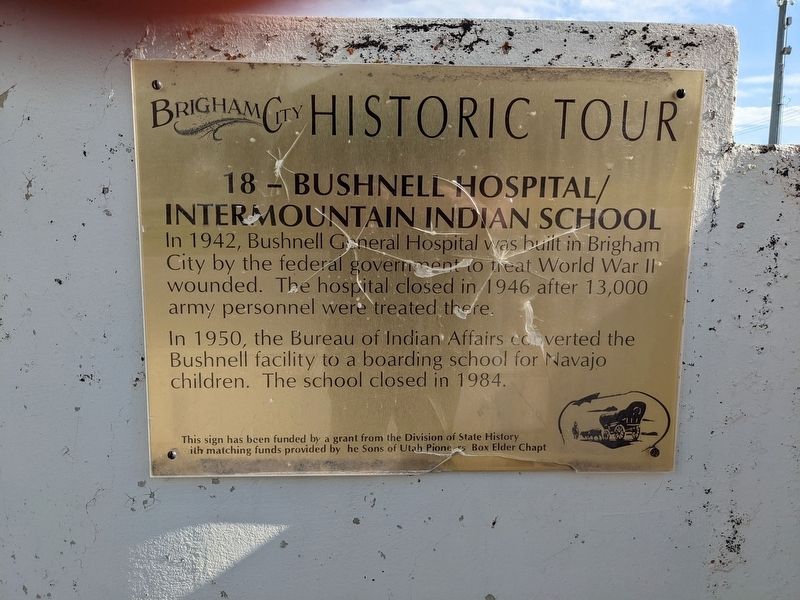
In 1942, Bushnell General Hospital was built in Brigham City by the federal government to treat World War II wounded. The hospital closed in 1946 after 13,000 army personnel were treated there.
In 1950, the Bureau of Indian Affairs coverted . . . — — Map (db m240490) HM
The same sun, moon and stars shone over these everlasting hills when old Lake
Bonneville's waters reached midway up these mountains. Later, native American
hunters roamed these lands which they called Woebequachee. Here they fished Pe-
Ogway . . . — — Map (db m240491) HM
The road through Nine Mile Canyon was constructed in 1886 by the Buffalo Soldiers of the U.S. 9th Cavalry to connect Fort Duchesne to the railroad in Carbon County. Most of the stagecoaches, mail and freight passed through Nine Mile into the . . . — — Map (db m72729) HM
Explorers, trappers and traders were here before Brigham Young sent a group, in 1861, to prepare the way for Mormon colonization. But in October 1861 the U.S. Government set apart Uintah Valley for Indian Reservation. In 1905 a portion was opened . . . — — Map (db m44051) HM
According to one tradition, the Duchesne River was named after Mother Rose Philippine Duchesne.
Mother Duchesne and the Catholic Sisters of the Sacred Heart of Jesus, had started schools in Missouri. The children of many of the early pioneer . . . — — Map (db m72766) HM
This is outlaw country! Hidden deep in these canyons, Butch Cassidy, Elza Lay, Flat Nose George, Kid Curry, Joe Walker, and others eluded the lawmen who pursued them in the late 1800s. In the 1850s Chief Wakara escaped into these badlands with as . . . — — Map (db m80465) HM
The first organized attempt to conquer the swirling rapids and precipitous walled canyons of the Green and Colorado Rivers was made by Major John Wesley Powell, Civil War hero and explorer.
Warned by Indians and mountaineers they would never . . . — — Map (db m102089) HM
"Before there were any Indians, the Legend People, To-when-an-ung-wa, lived in that place. There were many of them. They were of many kinds - birds, animals, lizards and such things - but they looked like people....For some reason, the . . . — — Map (db m40537) HM
A Place for Solitude In this vast landscape, you can immerse yourself in the sights, sounds, and textures of the natural world. Listen to a penetrating silence, broken only by the rasping call of a raven overhead. Walk amid rock formations that . . . — — Map (db m146599) HM
Homeland for Many Cultures People have lived in, named, and known this landscape for more than 11,000 years. Artifacts of their lives surround you. Ancient Puebloan peoples came to and through here from many places speaking many languages. . . . — — Map (db m146600) HM
The Last Frontier ”No animal without wings could cross the deep gulches in the sandstone basin at our feet. The stream which we had followed and whose course soon became lost in the multitude of chasms before us was not the one we were . . . — — Map (db m146681) HM
Height: flower stalk 1'-3'
Flower: greenish-yellow to cream
Bloom: spring
Each yucca species is pollinated only by one specific yucca moth; neither could survive without the other. A yucca blooms most years, with showy, bell-like . . . — — Map (db m159954) HM
Height: 2'-7'
Flower: small, in showy yellow clusters
Bloom: late summer-autumn
This common shrub has green photosynthetic stems. In autumn, it is covered by gold blooms. The flowers provide a late-season source of nectar for . . . — — Map (db m159955) HM
John Wesley Wolfe settled here in the late 1800s with his oldest son Fred. A nagging leg injury from the Civil War prompted John to move west from Ohio, looking for a drier climate. He chose this tract of more than 100 acres along Salt Wash for . . . — — Map (db m132029) HM
This monument commemorates the enduring strength of the Southern Paiute people and invites harmony among all that live upon or visit their homelands.
Today, the Southern Paiutes are organized in several Federally recognized Tribes (see map), . . . — — Map (db m241703) HM
This area, a part of the Great Basin, has evolved from the time of Lake Bonneville. It has known Anasazi Indian civilizations as evidenced by nearby ruins. It has seen the Dominguez-Escalante expedition of 1776 which passed west of this valley. It . . . — — Map (db m59620) HM
In July 1853, a trade of fish for flour between an Indian and Mrs. James Ivie, ended in a skirmish; one Indian died, Chief Walker refused peace offer of ponies, beef, flour and blankets unless Mr. Ivie stood trial by Indians; raids began. Colonel . . . — — Map (db m75456) HM
Prehistoric people survived in this semi-arid region by making the best of what the landscape offered. The Anasazi, or Ancestral Puebloans, found tillable soil and enough water to grow corn, squash, and beans. They lived in this area from . . . — — Map (db m130590) HM
The Ancient Ones
Evidence of the Anasazi's footsteps across the high plateaus of the area date back 2000 years. They were cliff dwellers who hunted deer and mountain sheep, and farmed the land. The Anasazi reached the peak of their culture . . . — — Map (db m41366) HM
The great Mormon frontiersman and Indian missionary settled in Tooele Valley, Utah in 1850 and began peaceful negotiations with the Red Men. He was so successful that the officials of the Church of Jesus Christ of Latter-Day Saints sent him to . . . — — Map (db m41254) HM
Clayton Moore and Jay Silverheels exemplified what heroes were supposed to be. They started their roles as "The Lone Ranger" and "Tonto" on the T.V. series in 1949 and would continue until 1957. Two feature films were also produced during the long . . . — — Map (db m41313) HM
Father Escalante camped here October 2, 1776. His exploring party of ten men headed by Father Francisco Dominguez and map-maker Pacheco preached to the Indians and charted a northern route between Santa Fe, New Mexico and Monterey, California. They . . . — — Map (db m1439) HM
There are three markers on this kioskCenter Marker
The Ute Domain
First described by Spanish explorers as the YUTA Indians (pronounced Ute-ah), the ancestors of the Ute people are thought to have migrated from the . . . — — Map (db m75470) HM
This town was named after the Indian Chief C'nos. Born in 1821 in California, he was a stately, intelligent and loving ruler of the Indians of Pahvant Valley. He died in 1884. — — Map (db m75516) HM
Walkara, Ute Indian chieftan, was one of the principal Indian chiefs when the Mormons first entered this area in 1848. Feared from California to New Mexico, he was a remarkably sly chief, daring horse thief, savage slave trader, furious enemy, . . . — — Map (db m75514) HM
(front of monument)
To the Memory of the
Koosharem Band
Paiute Indian Tribe of Utah
Massacred by local Mormon Settlers April 22–24, 1866
during Utah's Black Hawk War (1865–1872)
In remembrance of the innocent who were lost in . . . — — Map (db m154070) HM WM
During the Black Hawk War, on November 26, 1865, Ute Chief Tamaritz's band of around twelve warriors raided the thinly populated settlement of Circleville—ill-prepared to defend itself—killing four citizens.
Believing that Paiutes had . . . — — Map (db m154071) HM WM
The landscapes you see in our Native American Village represent the diversity of our state. The redrock “sandstone” represents the tribes of the Navajo and Piute people. The granite, grass, and stream represent the tribes of the Ute, Goshute, and . . . — — Map (db m184969) HM
On the present site of Draper Historic Park, with some expansion to the north and south, stood Draperville Fort. Fort Street was named for this historic enclosure.
According to the Eleventh General Epistle of the Presidency of The Church of . . . — — Map (db m224741) HM
The only human inhabitants in the area for centuries consisted of migratory Native American tribes. Sivogah (pronounced Si-voy-ah) meaning willows, was the Native American name for the area that later became known as Draper.
In the fall of . . . — — Map (db m224548) HM
The first known residents of the Riverton area were the Yo No Indians, a poor tribe living along the Jordan River. Well-worn trails extended from Utah Lake where various tribes wintered, to Bear Lake where they rendezvoused during the summer. Much . . . — — Map (db m34682) HM
Historic Indian Chief of Massachusetts Friend of the Pilgrim Fathers Sculptured by Cyrus E. Dallin Famous Utah Sculptor Plaster cast presented to the State of Utah by Mr. Dallin and accepted by the State of Utah on the 20th day of March, 1922 Cast . . . — — Map (db m167734) HM
Indian hunters probably used Ensign Peak as a vantage point to scout for prey. Many camped near the Warm Springs west of here, at the base of the mountain. The Salt Lake Valley was a meeting place and campsite for several bands which were composed . . . — — Map (db m225318) HM
The two prominent buttes in the distance are called the Bears Ears. Several native American groups, including the Navajos, Utes, and Pueblos, consider this area sacred and include it in their oral traditions.
One of the more popular Navajo . . . — — Map (db m93095) HM
This location marks the second encounter of one of the last Indian uprisings in the United States. Posey and his Piute followers helped 2 young braves escape from the Blanding jail. At this site the pursuing posse closed in, Posey opened fire and . . . — — Map (db m95047) HM
Welcome to “Hovenweep.” It is a Paiute and Ute word meaning “deserted valley.” It was the name given this extraordinary place by pioneer photographer William H. Jackson, who visited here in 1874. It’s an apt description. As . . . — — Map (db m71464) HM
Kachina (Ka-cheé-na) Bridge was named for the Hopi kachina spirits which frequently displayed lightning snake symbols on their bodies. Similar snake patterns were carved by prehistoric people on the base of Kachina Bridge.
Kachina Bridge is the . . . — — Map (db m93017) HM
Mule Canyon Ruin is an open Anasazi habitation site consisting of both above- and below-ground structures. This site was first occupied briefly in the Pueblo I time period (about A.D. 750) but the main occupation was during the Pueblo II and Pueblo . . . — — Map (db m95153) HM
Owachomo (O-wá-cho-mo) is a Hopi Indian word for rock mound. On the upper left side of the bridge is a rock outcrop which suggested the name for the bridge.
Owachomo Bridge looks different from either Sipapu or Kachina Bridge. Because Owachomo . . . — — Map (db m93094) HM
Several names have been given to the bridges over the years. Sipapu (Seé-pa-pu) has had at least two other names—President and Augusta—but these were later changed. Cliff dwellings and rock art in the area reminded William Douglass, the . . . — — Map (db m93093) HM
Over 700 years ago, Little Ruin Canyon was the scene of a sizable ancestral Pueblo community. Sustained by a small spring at the head of the canyon and rainwater held behind check dams on the mesa top, they flourished in what we would consider a . . . — — Map (db m71468) HM
In 1883, Cass Hite wandered up White Canyon from his mining claim on the Colorado River and “discovered” three stone bridges. He brought them to the attention of area residents and the scientific community. Nowhere else had three such . . . — — Map (db m132275) HM
The community's co-op store was located in the northeast corner of the fort. This cooperative venture, which provided a means for buying, selling and trading, became very successful. The Navajos and Utes also frequented the store, trading their . . . — — Map (db m95036) HM
Rising above the mesa, Aztec Butte overlooks sheer cliffs and twisted canyons stretching in every direction. Hundreds of years ago, ancestral Puebloans survived here through hard work and ingenuity. Clad in yucca sandals and bearing baskets of . . . — — Map (db m159891) HM
Harry and Leone (“Mike”) Goulding came to the valley in 1924, began building a home here and moved into this trading post in 1928. For more than 40 years they were traders and friends to the Navajos. In addition, they were hosts to . . . — — Map (db m149538) HM
In June 1849 Chief Wakara (or Walker), a Ute Indian, journeyed to Salt Lake City from the Sanpitch (Sanpete) valley to invite a group of Mormon settlers to come and live in the area. Chief Wakara wanted the settlers to teach his tribe how to . . . — — Map (db m243319) HM
In 1849, at Chief Wakara’s invitation, President Brigham Young sent about 225 Mormon pioneers to settle in the Sanpete valley. Initially, relations between the Mormon settlers and the local Ute Indians were helpful and cooperative, but tensions . . . — — Map (db m243327) HM
June 15, 1873 Brigham Young called Albert K. Thurber and George W. Bean, Indian interpreters, WM. B. Pace, William Jex and others to explore Grass Valley for settlement and make peace with the Indians. Chief Tabioonah accompanied the party and acted . . . — — Map (db m142661) HM
Was Made Here
June 14, 1873
This treaty led up to the final treaty at Cedar Grove in Grass Valley July 1, 1873, ending the Black Hawk Indian War in Southern Utah.
Present at the treaty council were:
Gen. Wm. B. Pace · George Evans · Byron . . . — — Map (db m138058) HM
Goshute people were one band of many Shoshone Indians
living in the Great Basin Region
The term "Gosiute" means "Kusiutta" describing their original dusty, well-traveled look. Goshute people inhabited the lush riparian areas of the region . . . — — Map (db m74276) HM
Perhaps a thousand years ago, someone climbed to the cliff face above, a stone tool in hand. Selecting an area of the sandstone darkened by minerals, that person began to chip away at the rock. After hours of chipping and carving, the image of a . . . — — Map (db m114460) HM
The first boat (framed together with wooden pegs) used for passengers and baggage was built and operated by Lars Jensen 2 ½ miles downstream from 1881 to 1909.
It was replaced by a cable ferry for wagons in 1885, and a larger boat in . . . — — Map (db m114450) HM
Jeremiah Hatch came to Ashley Valley in 1878 as an Indian agent. Following the Meeker, Colorado massacre of 1879 he was instructed to build a fort as protection for white settlers. Their cabins, with cedar post buttresses between, formed part of . . . — — Map (db m114422) HM
Eight rods W. of this marker was the S.W. corner of a fort erected for protection from the Indians in the Walker War. The walls enclosed three separate squares: in 1853, an 8 ft. mud wall built around a 33 r. sq. was named Fort Wordsworth; in 1854, . . . — — Map (db m224159) HM
Dedicated to the Two Hundredth Anniversary of the United States of America and sponsored by the
Utah American Revolution Bicentennial Commission
and Alpine Bicentennial Committee
John Rowe Moyle, emigrating from England in 1856 as . . . — — Map (db m224303) HM
In the spring of 1865 John Given with his wife Eliza and their four children, John Jr., Mary, Anna, and Martha, settled in the meadow land about 110 feet west of here. They built a cabin and willow shanty. Charles Brown and Charles W. Leah were . . . — — Map (db m139785) HM
Provo was settled by Mormon pioneers March 12, 1849. East of this monument a second fort was built in April, 1850. It was here that the settlers were threatened with massacre by Chief Walker and his Band of Indians, but were saved by Chief Sowiett's . . . — — Map (db m149444) HM
In February, 1850, militiamen from Fort Utah and Salt Lake City defeated the Timpanogots band of Utes in a pitched battle on the banks of the Provo River near what is now Riverside Plaza.
The Indians who survived escaped from the valley. . . . — — Map (db m223686) HM
Provo received its name from the Provo River, and how the Provo River received its name is quite a story.
When Spanish Fathers Dominguez and Escalante visited Utah Valley in 1776, they found it inhabited by Timpanogots Utes. In the native . . . — — Map (db m223624) HM
On July 29, 1776, Fathers Francisco Atanasio Dominguez and Silvestre Valez de Escalante led an exploration party of ten horsemen from Sante Fe, New Mexico to establish an overland route to Monterey, California, while spreading the Catholic faith to . . . — — Map (db m148739) HM
The Spanish Fork Indian Farm Reservation Comprising 20 square miles and extending from this state highway and the Spanish Fork River to Utah Lake, was set apart in 1854 by Brigham Young, Utah Supt. of U.S. Indian Affairs. Joseph E. Beck was . . . — — Map (db m148765) HM
When the Ute Indian Chief, Black Hawk died on September 27, 1870 near Spring Lake and was buried by his tribe in a nearby ravine, there was laid to rest a man designated by Brigham Young as "The most formidable foe amongst the Redman" that the . . . — — Map (db m148894) HM
Led by Captains John T. Baker and Alexander Fancher, a California-bound wagon train from Arkansas camped in this valley in the late summer of 1857 during the time of the so-called Utah War. In the early morning hours of September 7th, a party of . . . — — Map (db m46765) HM
In 1859, Major James H. Carleton interviewed Mrs. Rachel Hamblin, who lived a few miles north of the massacre field. Major Carleton carefully recorded her account of the surviving children, who were brought to her home on September 11, 1857, . . . — — Map (db m240466) HM
With the settlement of Toquerville in 1858 by the first six families and others soon to join them, they soon realized that the pressures on the available irrigated farmland could not support the increasing population. Survival would depend on . . . — — Map (db m59446) HM
From Native American Trail to Interstate Exit
A Local History of Passage
The earliest desert routes in the West followed water. Having drinking water for person or pack animal was critical in negotiating the extreme heat and rugged . . . — — Map (db m243204) HM
In early June 1854, eight members of the Southern Utah Indian Mission left Harmony to visit Toquer, chief of the Paiute Indian band living on lower Ash Creek. Chief Toquer's tribe referred to themselves as Paiute, Toquit, or Toquart Indians. They . . . — — Map (db m59467) HM
Original Inhabitants
Native peoples lived in the Zion area long before the first Euro-Americans came to this canyon. "Southern Paiutes believe they have lived in this area since the time of creation. Because of the abundance of animals, . . . — — Map (db m40425) HM
Until the late 18th Century, Zion's only visitors were the original inhabitants of the region. The earliest appearance of Europeans came in 1776 when the Dominguez-Escalante expedition after abandoning their quest for an overland route to . . . — — Map (db m80538) HM
Liberty was once called Little Valley by the Ute Indian Chief, Little Soldier. The first white men to visit this locality were trappers for Hudson Bay Fur Company, 1825. Here the Moroni Campbell family spent the winter of 1859, followed by other . . . — — Map (db m149614) HM
The confluence of the Ogden River and the Weber River has shaped this valley since Lake Bonneville receded. These waters supported the Shoshone people and their native predecessors. The rivers also supported early explorers and trappers, such as . . . — — Map (db m223570) HM