By Cosmos Mariner, July 14, 2018
Wolsey Notables (marker side 2)
| On Commercial Avenue (U.S. 14) south of Cardinal Street, on the left when traveling south. |
| On Main Avenue at Front Street, on the right when traveling south on Main Avenue. |
| On Court Street at Railroad Ave. SE, on the right when traveling north on Court Street. |
| On Main Street south of State Route 50, on the right when traveling east. |
| On Main Street south of State Route 50, on the left when traveling east. |
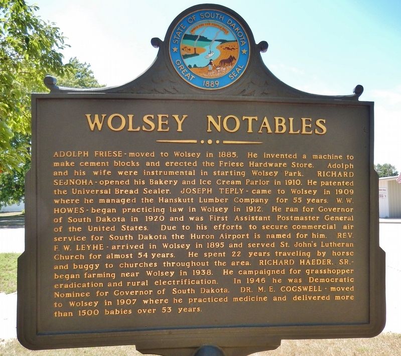
| On East Kemp Avenue east of North Maple, on the right when traveling east. |
| On North Broadway Street, 0.1 miles north of 1st Avenue North West. |
| On North Broadway Street, 0.1 miles north of 1st Avenue North, on the right when traveling north. |
| Near Broadway Street North, 0.1 miles north of 1st Avenue North, on the right when traveling north. |
| Near Montgomery Street at North 10th Street. |
| On Railroad Avenue East just east of Main Street, on the left when traveling east. |
| On South Main Street south of West Landmark Avenue, on the left when traveling north. |
| On South Dakota Route 20, 0.3 miles south of County Road 3, on the right when traveling south. |
| On U.S. 18, 0.5 miles west of Cemetery Road (County Highway 185), on the right when traveling west. |
| On 2nd Avenue (State Highway 471) north of G Street, on the right when traveling north. |
| On Highway 18, 0.5 miles west of Cemetery Road (County Highway 185), on the right when traveling west. |
| On Main Street east of Bridge Street, on the right when traveling east. |
| On East Oak Street at South Center Avenue, on the right when traveling east on East Oak Street. |
| On Main Avenue at Burlington Street, on the left when traveling east on Main Avenue. |
| On West Oak Street at West Broadway Ave, on the left when traveling west on West Oak Street. |
| On South Pierre Street south of East Dakota Avenue, on the left when traveling south. |
| On West Street at Main Street, on the right when traveling south on West Street. |
| Near Siever Street north of Pine Street, on the left when traveling north. |
| Near Charles Street (CanAm Highway) (U.S. 85) at Cedar Lane, on the right when traveling south. |
| Near Mount Roosevelt Road west of Stage Run Road. |
| Near Charles Street (CanAm Highway) (U.S. 85) at Cedar Lane, on the right when traveling south. |
| Near Charles Street (CanAm Highway) (U.S. 85) at Cedar Lane, on the right when traveling south. |
| Near Charles Street (CanAm Highway) (U.S. 85) at Cedar Lane, on the right when traveling south. |
| On Pine Street west of Sherman Street (CanAm Highway), on the right when traveling east. |
| Near Charles Street (CanAm Highway) (U.S. 85) at Cedar Lane, on the right when traveling south. Reported missing. |
| On Siever Street north of Pine Street, on the left when traveling north. |
| Near West Main Street (CanAm Highway) (U.S. 85) east of Stone Street, on the right when traveling east. |
| On West Main Street (CanAm Highway) (U.S. 85) east of Stone Street, on the right when traveling east. |
| On Englewood Road at Brownsville Road on Englewood Road. |
| On Englewood Road at Brownsville Road on Englewood Road. |
| On West Main Street (CanAm Highway) (U.S. 85) east of Siever Street, on the left when traveling east. |
| On West Main Street (CanAm Highway) (U.S. 85) west of Julius Street, on the right when traveling west. |
| Near West Main Street (CanAm Highway) (Route 85) east of Stone Street, on the right when traveling east. |
| On West Main Street (CanAm Highway) (U.S. 85) east of Stone Street, on the right when traveling east. |
| On West Main Street (CanAm Highway) (Route 85) east of Stone Street, on the right when traveling east. |
| On CanAm Highway (U.S. 85) north of U.S. 385, on the left when traveling north. |
| On CanAm Highway (U.S. 85) north of U.S. 385, on the left when traveling north. |
| On CanAm Highway (U.S. 85) north of U.S. 385, on the left when traveling north. |
| On U.S. 14A, 6 miles south of Business 90, on the left when traveling south. |
| On Meade Street at Laurel Street, on the right when traveling west on Meade Street. |
| On 478th Avenue (South Dakota Route 11) 0.8 miles north of 271st Street (County Road 106), on the right when traveling north. |
| Near 480th Avenue (County Highway 135) north of 270th Street, on the right when traveling north. |
| On Interstate 90 at milepost 221, on the right when traveling west. |
| On Interstate 90, 1.8 miles west of 441st Avenue (U.S. 81), on the right when traveling east. |
| On Aspen Boulevard west of South Splitrock Boulevard (State Route 11), on the right when traveling west. |
| On East 4th Street at South Charles Avenue, on the right when traveling west on East 4th Street. |
| On East 3rd Street west of Washington Avenue, on the right when traveling east. |
| Near North Weber Avenue, 0.2 miles south of East Falls Park Drive, on the right when traveling south. |
| On South Perry Place, 0.1 miles north of State Highway 42, on the left when traveling north. |
| Near North Weber Avenue, 0.2 miles south of East Falls Park Drive, on the right when traveling south. |
| Near Lyon Boulevard north of West 9th Street. |
| On East 8th Street west of North Weber Avenue, on the right when traveling east. |
| On South Phillips Avenue south of 9th Street, on the right when traveling south. |
| On North Cherapa Place north of East 8th Street, on the right when traveling south. |
| Near East 8th Street east of North Phillips Avenue, on the right when traveling east. |
| On West 5th Street (North Dakota Avenue) west of North Main Avenue, on the right when traveling east. |
| Near North Cherapa Place south of East 6th Street. |
| On North Phillips Avenue north of West 5th Street, on the right when traveling north. |
| On River Road, 0.1 miles north of East 10th Street (State Highway 42), on the right when traveling north. |
| On Interstate 90, on the right when traveling west. |
| On Water Street north of East Pipestone Avenue, on the left when traveling north. |
| Near Railroad Avenue at Elm Street. |
| Near Railroad Avenue at Elm Street. |
| Near Railroad Avenue at Elm Street. |
| Near U.S. 385 at Dead Broke Street, on the right when traveling north. |
| Near Deerfield Road, 0.6 miles north of Main Street (U.S. 385), on the right when traveling north. |
| Near Railroad Avenue at Elm Street. |
| On Railroad Avenue at Elm Street on Railroad Avenue. |
| On Badlands Loop Road (State Highway 240), on the left when traveling west. |
| On Native American Scenic Byway (Highway 83) at East 4th Avenue on Native American Scenic Byway. |
| Near Port Charlotte Avenue south of Jamison Drive, on the right when traveling east. |
| Near 317th Avenue north of U.S. 18, on the right when traveling north. |
| On County Road 1B, 0.1 miles north of 481st Avenue, on the right when traveling north. |