On Rue Iry Lejeune at South Horecky Street, on the right on Rue Iry Lejeune.
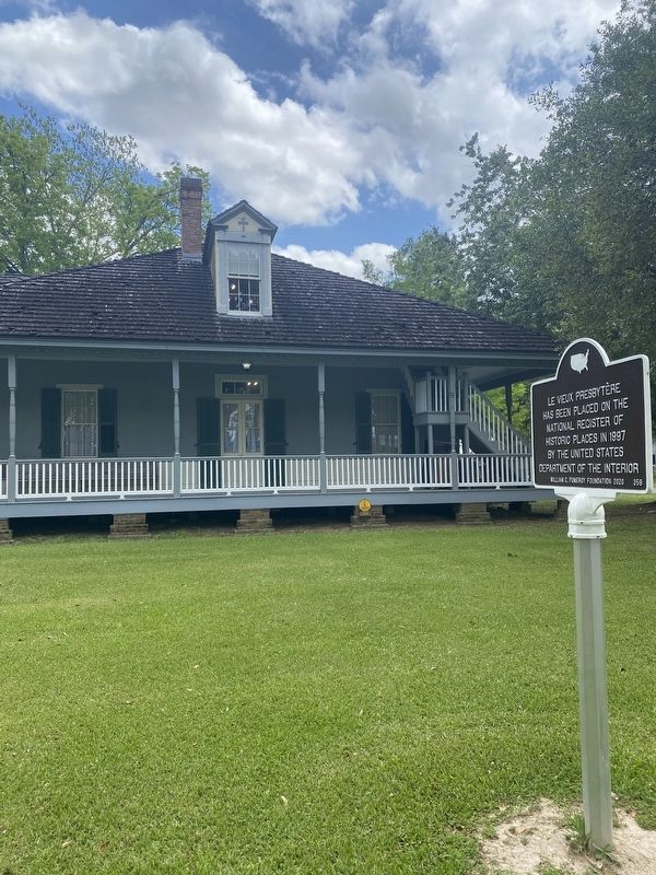
Le Vieux Presbytère has been placed on the National Register of Historic Places in 1997 by the United States Department of the Interior. — — Map (db m196525) HM
On South Adams Avenue (U.S. 90) at East Anding Street, on the right when traveling north on South Adams Avenue.
The site of St. Joseph's Catholic Church and Cemetery was determined after the new settlement of Rayne was established. Huge wooden wheels were made and the old church from the original Poupeville settlement was mounted on them and moved to this . . . — — Map (db m85307) HM
On Academy Drive, on the right when traveling east.
The Acadia Baptist Academy once occupied these buildings and grounds. The school was founded in 1917 by the Pilgrim Rest Baptist Church and the Southern Baptist Home Mission Board. Its purpose was to provide Christian education and training for . . . — — Map (db m89002) HM
On Hickory Flat Road, 1.4 miles north of U.S. 165, on the left when traveling north.
This property served as the first African-American school in Allen Parish until 1945. The land was deeded to the church in 1911 by Julian and his wife Modeste Captain. *School established in 1880 with Lawrence Shaw as first teacher. The original . . . — — Map (db m189219) HM
On Mississippi Street (State Highway 18) at St. Vincent Street, on the left when traveling north on Mississippi Street.
This church founded August 15, 1772 by Father Angel de Revillagodos on orders of King Charles III of Spain. Cornerstone of present church laid June, 1876 by Bishop Elder of Natchez and the April 14, 1896 dedication by Archbishop Janssens of New . . . — — Map (db m86048) HM
Near Mississippi Street north of Church Street, on the left when traveling north.
French missionary priests arrived here in 1704 to evangelize the Chetimaches Indians. Around 1770, Spanish militiamen built a log chapel here. In 1819 the parish erected the first official church building, followed by a brick church in 1843. . . . — — Map (db m155327) HM
On State Highway 308 at Freetown Rd., on the left when traveling south on State Highway 308.
Israel Baptist School. In 1872, Reverend Osborne Dickerson and the First Israel B. C. congregation organized the Baptist Church School on this site to provide formal education for African American children. In 1877, Assumption Parish School . . . — — Map (db m86041) HM
On State Highway 1 at State Highway 1008, on the right when traveling south on State Highway 1.
Site of Elm Hall Plantation donated by Dr. E. E. Kittredge. Congregation organized and church constructed in 1853. Frank Willis, Architect. Consecrated by the Rt. Rev. Leonidas K. Polk in 1854. W.W. Pugh, Warden, 1853-1905. — — Map (db m87901) HM
On State Highway 70 at South Bay Road (State Highway 1015), on the right when traveling south on State Highway 70.
Commemorates The Blessed Virgin who the people of Pierre Part believe intervened to save lives in natural disasters from 1882-1976. Restored by the citizens during the Bicentennial Year 1976. — — Map (db m85754) HM
On Bayou Drive West, 0.5 miles south of Lee Drive.
Commemorates The Blessed Virgin who the people of Pierre Part believe intervened to save lives in natural disasters from 1882-1976. Restored by the citizens during the Bicentennial Year 1976. — — Map (db m98425) HM
On Whites Chapel Road, 0.3 miles south of State Highway 29, on the right when traveling west.
Gothic Revival church built in 1894 by Hugh and Lee Evans on land donated by Wilson A. O'Quin, Sr. It was named in honor of Rev. Frederick White who organized it in 1870. Listed on the National Register of Historic Places. — — Map (db m107478) HM
On Tunica Drive East (State Highway 1/107) south of Airport Drive, on the right when traveling south.
Site of first Catholic school in Avoyelles Parish - 1855. Founded by Daughters of the Cross of Treguier, France, under Mother Mary Hyacinth Le Conniat on request of Bishop Martin. Battle of Mansura, May 16, 1864, began on Convent grounds. — — Map (db m110431) HM
On Legion Drive near North Preston Street (State Highway 452), on the left when traveling east.
Organized in 1889 under the leadership of Rev. J.W. Womack of Beggs, Oklahoma. Rev. and Mrs. Womack opened the first private "colored" school in Avoyelles Parish. Rev. A.L. Holmes was pastor of this church for 37 years. — — Map (db m138654) HM
On South Preston Street (State Highway 452) near East Mark Street, on the right when traveling south.
Frame structure with Greek Revival influence was built for the Black Catholic families of Marksville and staffed by the Holy Ghost Fathers. Rev. Fr. T.J. Nolan was the first pastor and this church was built by Rev. Fr. John Cooney. — — Map (db m117651) HM
On South Preston Street (Louisiana Route 452) south of East Mark Street, on the right when traveling south.
Established September 1919, In Marksville, Louisiana by the Diocese of Alexandria, LA primarily for Black Catholics, a common practice of that era. Originally staffed by Holy Ghost Fathers. Currently, serves a congregation of 90% plus Black . . . — — Map (db m214333) HM
On East Mark Street west of South Preston Street, on the left when traveling west.
Founded by
Rev. Fr. Nicholas Juderman
as a school for Black Catholic
children. Land donated by
Daughters of the Cross.
Funding obtained from
Mother Katherine Drexel,
founder of the Sisters of
the Blessed Sacrament.
Opened in 1917. First . . . — — Map (db m122502) HM
On North Main Street (State Highway 115) north of Joffrion Street, on the right when traveling north.
First organized in 1896 at the corner of Waddil and Lee Sts. by Rev. C. R. Dellapine. Later moved to corner of Monroe and Ogden Sts., and to this location in 1947. — — Map (db m98179) HM
On North Main Street south of Joffrion Avenue, on the right when traveling south.
The Marksville Church of the
Nazarene was organized on
October 26, 1926 in the home
of Mrs. L.J. Coco. Rev. L.L.
Latham was the first minister.
This "New England” style
building has outstanding twelve
over twelve windows. . . . — — Map (db m122524) HM
On South Washington Street north of East Wadill Street, on the right when traveling north.
Founded by the Daughters of the Cross of Treguier, France in 1854 at Hydropolis (Cocoville), and relocated to this site after the Civil War. First Catholic girls' school in Avoyelles Parish. Later became co-educational. — — Map (db m122415) HM
On East Waddil Street, 0.1 miles east of South Washington Street, on the right when traveling east.
Originally located in Hydropolis (Cocoville). Served as the chapel for the Daughters of the Cross and students at Presentation Academy. Later moved after the Civil War to Marksville and attached to the first St. Joseph Church. Moved to the grounds . . . — — Map (db m97771) HM
On South Washington Street near East Waddil Street, on the right when traveling north.
Founded by Rev. Fr. Jules Janeau in 1869 with worship in a Gothic frame Church. Replaced in 1926 by Msgr. Henry Van de Putten with this Romanesque structure designed by W. T. Nolan. — — Map (db m98023) HM
On West Bon Temps Street, 0.2 miles north of North Monroe Street, on the right when traveling north.
Congregation established in 1881 as a mission from St. James Church in Alexandria. Rev. W.S. Slack was pastor of the church on this site in 1902. — — Map (db m121239) HM
On Bayou des Glaises Street (State Highway 4561) 0.2 miles north of Fox Street, on the right when traveling north.
The first church for Catholics in the Moreauville area along Bayou des Glaises was built in 1858 and known as St. Hyacinthe's Mission Chapel that was administered by St. Paul's Church, Mansura. Widow Aimee Joffrion Boyer donated the property on . . . — — Map (db m99181) HM
On Old Campground Cemetery Road, 0.5 miles east of Pentecostal Church Road (Parish Highway 370).
Main Panel A Waypoint through the Years
Old Campground stands near an ancient ford (a shallow place with good footing where a waterway can be crossed) on Sugar Creek, and the proximity of Old
Campground to this ford is not a coincidence, . . . — — Map (db m189246) HM
Near State Highway 507, 2.7 miles west of State Highway 147, on the right when traveling west.
Facts about the MountainThe mountain was named for James Christopher Driskill. He was born in Hancock County, Georgia, on June 17, 1817. In 1840 he married Eugenia Irwin Walker. In October 1859, Mr. Driskill sold his land in Georgia, and moved . . . — — Map (db m166115) HM
On State Highway 507, 0.8 miles west of State Highway 797, on the right when traveling west.
Near this spot is the trailhead to Driskill Mountain, Louisiana's highest point and the Mt. Zion Presbyterian Church and Cemetery. James Christopher Driskill, the mountain's namesake. was born in Hancock County, Georgia, on June 27, 1817. On October . . . — — Map (db m234596) HM
On Church Street north of White Street, on the right when traveling north.
The property for Belcher Methodist Church was purchased in 1916 after over two years of fundraising. A white wood frame church was built that same year. In 1954 that structure was raised and a new brick church was built. Several men in the . . . — — Map (db m175189) HM
On Gray Street (State Highway 3049) north of Louisiana Street, on the right when traveling north.
Belcher Presbyterian Church was organized on July 18, 1897, as the Red River Presbyterian Church. The congregation met in a vacant store building on Rush Point Plantation where services were held until 1900, when a one room frame building was . . . — — Map (db m87130) HM
On Dixie Shreveport Road (Louisiana Route 3049) south of Louisiana Route 169, on the left when traveling north.
Cornerstone Missionary Baptist Church was started in a house on the back of the Corner Place in Dixie, Louisiana. The first prayer meeting and a revival was held there in late 1889. Led by Rev. Eddie Moore, Pastor. Cornerstone Church congregation . . . — — Map (db m175731) HM
On Dixie Shreveport Road (Louisiana Route 3049) 0.5 miles south of Louisiana Route 169, on the left when traveling north.
The church began in 1902 as the Presbyterian -Methodist Church of Dixie as a result of an agreement between the minister, Mr. Ziegler and Mr. Ivey, who donated the land on North Road for the church. In 1904 the Red River Presbytery organized the . . . — — Map (db m175732) HM
On Adger Road at Piarce Lane, on the right when traveling east on Adger Road.
The first worship services in Gilliam were held in a railroad box car. In 1902 Gilliam Methodist Episcopal Church, South was built across Red Bayou north of the present church. That building was destroyed in the storm of 1908, along with all but one . . . — — Map (db m174465) HM
On Louisiana Route 3049, 0.5 miles south of Sherman Drive, on the left when traveling south.
The Justice Chapel Baptist Church was organized in 1894 under the leadership of Rev. C.J. Justice and Brother Willie Davenport and his wife. Other leaders in this early church were Rev. Eddie Moore, Brother Eddy Green, Brother Frank Cook, Mathis . . . — — Map (db m174630) HM
On Louisiana Route 3049 south of Sartor Road, on the left when traveling south.
Organized June 6, 1919, with 12 charter members, and named in honor of Mrs. Linda Lay who had been instrumental in the development of the spiritual life in the town. Constructed in 1920, dedication of the building was held on August 14, 1921. The . . . — — Map (db m174628) HM
On U.S. 71, 0.2 miles south of State Route 2, on the right when traveling north.
On June 23, 1912, twelve charter members organized the Hosston Methodist Church. At first they worshiped at the Baptist Church then in 1916 built a white wood frame church which faced east on this spot. In 1940 as the membership grew two porches . . . — — Map (db m173876) HM
On East Magnolia Lane near U.S. 71, on the right when traveling east.
Settlement in the Ida area began before 1840, with increasing numbers coming from the East after the Civil War. They came by ox-drawn wagons or by steamboat. Earliest permanent settlers were Readrick Kelly, Chesley Green Williams, the Munnerlyn . . . — — Map (db m173788) HM
On Old Mansfield Road south of Keithville Lodge Road, on the right when traveling north.
Built 1903-04. Constructed by Tom Hudnall. Dedicated Oct. 16, 1904. Bell came from Teer family plantation, Coushatta, Louisiana. — — Map (db m176072) HM
Near Texas Avenue north of Lawrence Street, on the right when traveling north. Reported missing.
1057 Texas Avenue founded in 1866. Oldest Black Baptist Church in Shreveport. Built Present location in 1903. Romanesque Revival Style, by noted Architect N. S. Allen — — Map (db m180320) HM
On Cotton Street east of U.S. 79/80, on the right when traveling east.
Conducted First Episcopal Service in Shreveport March 24, 1839. St. Paul's Church Formed 1845. Renamed Grace Church 1851. Renamed St. Mark's 1859. St. Mark's Relocated 1954. Holy Cross Organized 1954. — — Map (db m139948) HM
On Common Street at Texas Street (U.S. 79/80), on the right when traveling south on Common Street.
First United Methodist Church operated as a station church on the Greenwood-Shreveport Circuit from the 1830s and established its first building in 1845 on Market Street between Travis and Fannin. The congregation moved to this location at the "Head . . . — — Map (db m109769) HM
On Cotton Street, on the left when traveling north.
Designed by Edward Neild and Clarence Olschner with interior design work by Paul Heerwagen. Built in 1914. Housed B’nai Zion Synagogue -- founded 1859 -- from 1915 to 1956. Ten stained glass windows are by Lafarge. Listed in National Register of . . . — — Map (db m214289) HM
On Pierre Avenue south of Looney Street, on the right when traveling north.
Founded 1865. Previous St. Paul's church building built 1889 and located on Caddo Street in the low lying area to it which gave it's name: St. Paul's Bottoms. Present Gothic Revival style building constructed 1926. — — Map (db m142881) HM
On Cotton Street east of Texas Street (Highway 79/80), on the right when traveling east.
In 1904, the oldest religious body in Shreveport, St. Mark's Episcopal Church, began building this cathedral. Then in 1954, St. Mark's decided to move to a more suburban setting; there was a select group of members that remained behind and founded . . . — — Map (db m139949) HM
On Marshall Street at Fannin Street, on the left when traveling south on Marshall Street.
Established in 1856, Holy Trinity was moved to this site in 1858. Five of its priests lost their lives treating the victims of the Yellow Fever Epidemic of 1873. The present church, in Romanesque Revival style, was built in 1896. — — Map (db m168349) HM
Near Market Street at Texas Street (U.S. 79), on the right when traveling south. Reported missing.
In 1845 three of Shreveport’s first churches were organized within a four block span of Market Street: First Baptist at Travis and Market, SE; First Presbyterian, 600 block of Market, west side; and First United Methodist at Market and Fanning, SW. . . . — — Map (db m180325) HM
On Jordan Street west of Cicero Street, on the left when traveling west.
Founded 1845, present sanctuary built 1925, Designed by architectural firm of Jones, Roessle, Olschner and Wiener. Chapel adjoining buildings added later. Unusual curved pews are a noteworthy feature of the sanctuary. — — Map (db m142857) HM
On Kings Highway west of Line Avenue, on the right when traveling west.
Built 1925. Designed by prominent local architect Samuel Weiner, Jr. One of Shreveport's premier examples of Romanesque/Byzantine architectural styles. — — Map (db m143743) HM
On Herndon Street east of Stephens Avenue, on the left when traveling east.
Founded as a mission church in 1906, Noel memorial Methodist Church built present building in 1913. When completed, this was the city's largest church building. Fire destroyed all but the exterior walls in 1925. — — Map (db m142327) HM
On Line Avenue at Margaret Place, on the right when traveling west on Line Avenue.
Built 1938 for Agudath Achim Orthodox Jewish Congregation which occupied it from 1939 to 1980. Art Deco in style, the building was designed by Seymor Van Os. — — Map (db m142132) HM
On Creswell Avenue at Wichita Street, on the right when traveling north on Creswell Avenue.
Designed by J.P. Annan. Built 1934. Named as a memorial to the St. George Church in New Ephesus, Greece, which was destroyed by the Turks 1917. Congregation founded 1917. — — Map (db m142432) HM
On Fairfield Avenue south of Robinson Place, on the right when traveling south.
Built 1923 by prominent attorney Henry Clay Walker, Jr. Later residence of Coca Cola bottler Zehntner Biedenharn. Housed State Missionary Headquarters of Church of Jesus Christ of Latter Day Saints 1961-1975. Architects: Maritz & Young of St. Louis, . . . — — Map (db m138863) HM
On Texas Avenue (U.S. 80) west of Levy Street, on the right when traveling west.
Opened 1882 as city's Catholic Cemetery. Several priests who died in 1873 yellow fever epidemic rest here, including Father Jean Pierre, founding pastor of Holy Trinity Church. Also many pioneer members of Shreveport's French and Italian Societies . . . — — Map (db m143742) HM
On Hall Street near West Harrison Street, on the right when traveling north.
Built in 1885 in Patterson, La. and originally known as Holy Trinity. Moved to present location in 1942. Listed on the National Register of Historic Places because of its Gothic Revival architecture. — — Map (db m140550) HM
On Kirby Street near Ford Street, on the right when traveling west.
Christian Science was discovered by Mary Baker Eddy in 1866. This church is one of the many world wide branches of The Mother Church, The First Church of Christ, Scientist, in Boston, Massachusetts, organized by her in 1879.
By 1890, a group of . . . — — Map (db m136264) HM
On Seventh Street south of Bank Street, on the right when traveling east.
Area congregations constructed a two-story orphanage in 1899 that housed up to 150 children at a time. This location was selected for the wholesome, rural character of the setting. The landmark structure was so identified with this part of the . . . — — Map (db m116272) HM
On Ryan Street (State Highway 385) at Seventh Street/Dr. Michael Debakey Drive, on the right when traveling south on Ryan Street.
The original site of St. Charles Academy was the northeast corner of Ryan and Kirby, part of the Roman Catholic complex of church, convent and school destroyed in the Great Fire of 1910. Opening in 1882, St. Charles Academy was staffed by the . . . — — Map (db m116323) HM
Near Ruth Street south of Cypress Street, on the left when traveling north.
The Henning Family arrived in Calcasieu Parish in approximately 1875 and began to lay the foundation for a remarkable tenure as community, business and industry leaders. Reverend John Henning and Family, including son John Thomas Henning, arrived in . . . — — Map (db m109527) HM
On Church Street at Riser Street, on the right when traveling east on Church Street.
Methodists have worshipped in
a building on this site since
before 1840. Circuit riders
served congregation until 1847,
when first pastor appointed.
Present building completed in
1911 from plans brought from
Europe by a church member. — — Map (db m120260) HM
On Friendship Road just west of Wright Road, on the right when traveling west.
From 1965-1937, the Friendship CME Church served as the house of worship in Claiborne Parish where the Claiborne Parish Civic League (CLPL), a local activist organization, met and organized plans to bring fair and just changes throughout the parish . . . — — Map (db m180149) HM
On Summerfield Highway (Alternate State Highway 2) at Corney Lake Road, on the right when traveling west on Summerfield Highway.
Alabama Methodist Church has been placed on the National Register of Historic Places in 1995 by the United States Department of the Interior — — Map (db m209818) HM
On North 1st Street (State Highway 568) south of Greathouse Street, on the right when traveling south.
For more than a quarter of a century, Frank Morris operated one of the most successful African-American businesses in Concordia Parish. From the late 1930s until 1964, Morris’ shoe shop on Hwy. 84 in Ferriday was one of the busiest establishments in . . . — — Map (db m126998) HM
On Louisiana Avenue at EE Wallace Boulevard (U.S. 425), on the right when traveling east on Louisiana Avenue.
Jerry Lee Lewis, aka The Killer, was born in 1935, in Ferriday, LA, where he began playing piano in his youth with his cousins, Mickey Gilley and Jimmy Swaggart. He grew up listening to broadcasts of the Louisiana Hayride and Grand Ole Opry on the . . . — — Map (db m104041) HM
On Louisiana Avenue near E.E. Wallace Boulevard (U.S. 425).
Go ye into all the world and preach the Gospel to every creature (Mark 16:15) Jimmy Lee Swaggart was born March 15, 1935 in Ferriday, Louisiana. Ministering the Word under the anointing of the Holy Spirit, he preached to stadiums filled with . . . — — Map (db m104066) HM
On Grove Hill Road at State Route 175, on the right when traveling east on Grove Hill Road.
The Dolet Hills or "Double Churches" community was organized by homestead settlers in the 1850's on a late 1700's Spanish Land Grant to Pierre Dolet. The Lord, Griffith and Pace families were among the earliest arrivals. There were many family . . . — — Map (db m105342) HM
On Louisiana Route 175 at Parish Road 1068, on the right when traveling north on State Route 175.
By 1850 Old Pleasant Hill was a thriving community settled by the Blackshear, Jordan, Chapman, Childers and Elam families. Significant structures included the Methodist Church, Pierce-Payne College, Childers Mansion and the Elam House. When the . . . — — Map (db m105386) HM
On North Boulevard at East Boulevard, on the right when traveling east on North Boulevard.
Methodist preachers, known as "circuit riders", began ministering in the Baton Rouge area in the 1820's. The Methodist Episcopal Church incorporated in 1834, Rev. Charles K. Marshall, Pastor. The congregation built their first church near the . . . — — Map (db m87270) HM
On Chapelwood Drive south of Woodland Ridge Boulevard, on the right when traveling south.
Original Site
On February 1, 1968, the donation of 20 acres to the Episcopal Diocese of Louisiana was received and ground broken on this site by the Rt. Rev. Iveson B. Noland for the construction of Episcopal High School.
Donors of . . . — — Map (db m97659) HM
On Convention Street near North 4th Street, on the right when traveling west.
The congregation first organized in 1819, received their charter as St. James Church in 1844. The second church, of Gothic Revival style, was completed in 1895. Mrs. Zachary Taylor was an early member. — — Map (db m88274) HM
On North 5th Street south of Laurel Street, on the right when traveling north.
This site was purchased by the organizers of what is today Congregation B'Nai Israel, one of the oldest Reform Jewish congregations in America. The earliest records of the congregation date to 1858. The original charter stated the Congregation's . . . — — Map (db m98268) HM
On North 4th Street at Laurel Street, on the right when traveling north on North 4th Street.
Incorporated January 25, 1834, the church was built on this site in 1836, Charles K. Marshall, Pastor. Enlarged under the leadership of the Reverend William E. M. Linfield in 1860, it was used until March 28, 1926, when the congregation moved to a . . . — — Map (db m88303) HM
On Florida Street (Business U.S. 61/190) at North 4th Street, on the right when traveling east on Florida Street.
Organized May 27, 1827, after twelve years of missionary work by the Presbytery of Mississippi, John Dorrance first minister. Sanctuary dedicated in 1829. Rebuilt in 1854 on the same site and used until 1926 when new building was erected on the . . . — — Map (db m85342) HM
On Spanish Town Road at North Seventh Street, on the left when traveling east on Spanish Town Road.
On July 7, 1872, Rev. George Bird and the congregation of Shiloh Church dedicated the cornerstone of their new frame church on this site. For more than forty years the Church occupied a prominent place in the life of Spanish Town. In March 1918 this . . . — — Map (db m87371) HM
On Main Street at Norrth Fourth Street, on the left when traveling east on Main Street.
Built in 1853 to 1856 on the site of two earlier churches. The first erected about 1790 under Spanish rule was called "Our Lady of Sorrows." The first marriage recorded was that of Don Antonio Gras, an early Spanish resident who donated the land. . . . — — Map (db m87854) HM
On North Street at North 4th Street, on the right when traveling west on North Street.
The Brothers of the Sacred Heart founded St. Vincent's Academy on this site in 1894. In 1929 the school for boys was replaced by a larger facility and renamed Catholic High School. In 1957 the school was moved to its present location on Hearthstone . . . — — Map (db m87444) HM
Near Main Street west of North 4th Street, on the left when traveling west.
The former Baptismal fount from St. Joseph Cathedral. The first baptism recorded here was Juan Josef Trahan, son of Juan Marie Trahan of Morlaix, Britanny, France and Adelaida Tulier of Cherbourg, Normandy, France. He was born June 19, 1793 and . . . — — Map (db m93354) HM
Near Essen Lane (State Road 3064) south of Interstate 10, on the right when traveling south.
The church was built in the Gothic Revival Style and exemplifies the style's basic elements: a central aisle, a three-sided apse, and modified lancet windows and doors. The windows are of painted, rather than stained, glass, which was a custom . . . — — Map (db m112100) HM
On Main Street east of North 15th Street, on the left when traveling east.
In 1825 St. Joseph Church purchased this property for a graveyard. Remains of some of Baton Rouge's first settlers were moved here from the old Spanish Cemetery, or cemetery of the Church of Our Lady of Sorrows, which became St. Joseph's. Philip . . . — — Map (db m85156) HM
On Greenwell Springs Road (State Highway 37) at Frenchtown Road, on the right when traveling north on Greenwell Springs Road.
Worshiping Catholics have gathered at this site since 1898. St. Francis of Assisi Mission Church was established with funds raised by Amelia Landry and built on land donated by Talbot Richard. It became St. Alphonsus Liguori Parish in 1962. Guided . . . — — Map (db m85313) HM
On Scenic Highway near Teal Street, on the right when traveling north.
In 1917, Taylor M.E. Church was founded as the
first Methodist church in Scotlandville (nee:
Scotland) by twelve visionary African-American
Methodists. In 1922, the name changed to
Camphor Memorial M.E. Church. In 1968, its
current name was . . . — — Map (db m163429) HM
On Church Street north of Marston Street, on the right when traveling north.
First Episcopal services in Clinton conducted in 1842 by Rev. William B. Lacey, president of College of Louisiana at Jackson. Parish organized in 1852. Rev. Frederick Dean was first resident priest. Present church dates from 1871. . . . — — Map (db m92420) HM
On Sycamore Street at Bank Street, on the right when traveling west on Sycamore Street.
Host to Mississippi Conference in 1854. The Gothic building with a Revival basilica, slave gallery, windows depicting cross and crown of thorns, has served its congregation 140 years. — — Map (db m85820) HM
On Calvary Baptist Road, 0.3 miles west of U.S. 167, on the right when traveling west.
Joseph Willis was the first Baptist minister to preach the Gospel
west of the Mississippi River. Between 1804-1805, Willis arrived in
Bayou Chicot, Louisiana, where he began evangelizing and meeting
with believers. This group did not establish . . . — — Map (db m134958) HM
On Louisiana Route 135, 0.3 miles south of Live Oak Lane, on the right when traveling south.
Oldest church in Franklin Parish. A campground was established in 1806 at Boeuf Prairie, first permanent settlement in the area, became the site of a true house of worship in 1833. The church served as the courthouse for a time after formation of . . . — — Map (db m195737) HM
Prospect School had its beginning in the late 1800s, having its
first class at Prospect Baptist Church, which was across the
road from where the first building was built. In the late 1920s
or early 1930s, the first building was destroyed by a . . . — — Map (db m124015) HM
In 1936, a year after Jungle Gardens opened to the public, two of McIlhenny's
friends, Robert M. Youngs and Ernest B. Tracy of New York City, presented him
with a magnificent Buddha statue that they hoped would find an ideal home
among his Asian . . . — — Map (db m118857) HM
This Buddah Was built for the Shonfa Temple located northeast of Peking, by the order of Emperor Hui-Tsung 1101-1125
Its builder was Chon-Ha-Chin, most noted of ancient Buddah makers.The temple was looted by a rebel general who took . . . — — Map (db m118855) HM
On St. Nicholas Street at Church Street, on the right when traveling north on St. Nicholas Street.
Founded 12 January 1879 by Napoleon J. Perche, Archbishop of New Orleans. The present church was built in 1908, Rev. M. Bardy, pastor, August 1885 - June 1928. — — Map (db m86664) HM
On Jefferson Street at West Main Street (Louisiana Highway 182), on the right when traveling west on Jefferson Street.
Consecrated in 1858 on land donated by plantation owner Harvey Hopkins, the Episcopal Church of the Epiphany is the oldest church building still in use in New Iberia. It was added to the National Register of Historic Places in 1977. One thing . . . — — Map (db m99361) HM
Near East Main Street near Bridge Street, on the left when traveling north.
Frédéric Henri Dupérier, under whose leadership New Iberia was
incorporated in 1839, along with his wife, Hortense Bérard, donated the
land for St. Peter's Catholic Church in 1837. Dupérier asked that this alley remain open for his family's . . . — — Map (db m129771) HM
Frédéric Henri Duperier originally donated Church Alley
to the City of New lberia. The Duperier family lived across
the Bayou Teche in the mansion that was to become
Mt. Carmel Academy. In 1837, Duperier donated the land
for St. Peter's Catholic . . . — — Map (db m129999) HM
On East Main Street (State Highway 182) near Civic Center Circle, on the right when traveling north.
St. Peter's College, a Catholic boys' school, opened on September 9, 1918, and educated young men in grades 1-12. The first commencement was held on June 20, 1922. Inaugural faculty members were Brother A. Arsenius (principal), Brother A. Xavier, . . . — — Map (db m99403) HM
On Bridge Street, on the right when traveling west.
An educational institution for girls established in 1872 by the Sisters of Mt. Carmel. The order was founded in 1825 in Tours, France. The old building which is nearest Bayou Teche was constructed by Henry F. Duperier in 1826. — — Map (db m49066) HM
On East Main Street (State Highway 182) near Civic Center Drive, on the right when traveling north.
On this site stood the 1885 Gothic Revival home of John Marsh Henshaw, purchased by Monsignor Jean Marie Langlois in 1913, Saint Peter's College began educating boys on September 9, 1918. A school building was constructed east of the Henshaw . . . — — Map (db m99402) HM
On West Main Street (State Highway 182) at Jefferson Street (Route 3156), on the left when traveling west on West Main Street.
Built in 1858 on land donated by Harvey Hopkins. Consecrated May 16, 1858 by the Rt. Rev. Leonidas Polk, first Episcopal Bishop of Louisiana. This Gothic Revival structure is the oldest non-residential building in New Iberia. During the War Between . . . — — Map (db m86911) HM
On Point Clair Road (State Highway 141) 1 mile north of Martin Luther King Parkway (State Highway 75), on the right when traveling north.
In 1895, the Louisiana Leper Home Board of Control needed to secure nursing services for the first patients. They approached a Catholic nursing order with the promise of furnishing sleeping and living arrangements. The Daughters of Charity of St. . . . — — Map (db m104258) HM
On Court Street (State Highway 3066) at Church Street (Route 1), on the right when traveling west on Court Street.
Built in 1847 by Dr. Edward Scratchley. Occupied as school by Marianite Sisters from 1859-1862 & 1865-1975. Occupied as military command by Union Army 1862-1865. Renovated by Lt. Governor and Mrs. Robert L. Freeman-1990 — — Map (db m87254) HM
On Church Street (State Highway 1) north of Meriam Street, on the right when traveling north.
Methodist circuit riders came out of Mississippi into this area
soon after the Louisiana Purchase of 1803. A Union church building was erected in 1841 on what is now the parking lot of the present Methodist Church. This church served Methodists, . . . — — Map (db m127884) HM
325 entries matched your criteria. The first 100 are listed above. Next 100 ⊳