After filtering for Maryland, 948 entries match your criteria. The first 100 are listed. ⊳
Colonial Era Topic
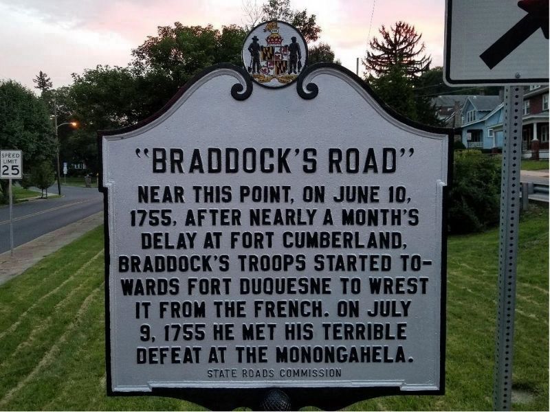
By William Richard Harrison, July 4, 2018
"Braddock's Road" Marker (restored)
| 1 ► Maryland, Allegany County, Cumberland — "Braddock's Road" — |
| On Braddock Road (Maryland Route 49) at Greene Street (U.S. 220), on the left when traveling west on Braddock Road. | |||
| 2 ► Maryland, Allegany County, Cumberland — Abandonment of Ft. Cumberland — Fort Cumberland Trail — |
| Near Prospect Square. | |||
| 3 ► Maryland, Allegany County, Cumberland — Baltimore Street Bridge — City of Cumberland, Maryland — Built 1916 — |
| On Greene Street at Baltimore Street, on the right when traveling north on Greene Street. | |||
| 4 ► Maryland, Allegany County, Cumberland — Col. Thomas Cresap — |
| Near Greene St.. | |||
| 5 ► Maryland, Allegany County, Cumberland — Cumberland — |
| On Great Allegheny Passage, 0.1 miles north of Baltimore Street, on the left when traveling north. | |||
| 6 ► Maryland, Allegany County, Cumberland — Famous Personalities at Fort Cumberland — Fort Cumberland Trail — |
| On Prospect Square at Washington Street, on the left when traveling south on Prospect Square. | |||
| 7 ► Maryland, Allegany County, Cumberland — George Washington at Will’s Creek — Fort Cumberland Trail — |
| On Greene Street at Bridge Street on Greene Street. | |||
| 8 ► Maryland, Allegany County, Cumberland — Headquarters of George Washington — |
| Near Greene Street at Bridge Street. | |||
| 9 ► Maryland, Allegany County, Cumberland — Indians and Fort Cumberland — Fort Cumberland Trail — |
| On Washington Street just east of Prospect Square, on the right when traveling east. | |||
| 10 ► Maryland, Allegany County, Cumberland — Jane Frazier — Wife of Lieut. John Frazier — |
| On Evitts Creek Drive Southeast south of East Industrial Highway (Maryland Route 51), on the right when traveling south. | |||
| 11 ► Maryland, Allegany County, Cumberland — Ohio Co. and Fort Cumberland — Fort Cumberland Trail — |
| On Greene Street at Baltimore Street, on the right when traveling north on Greene Street. | |||
| 12 ► Maryland, Allegany County, Cumberland — Our Local Indian Heritage — Fort Cumberland Trail — |
| On Greene St.. | |||
| 13 ► Maryland, Allegany County, Cumberland — Perimeter of the Fort — Fort Cumberland Trail — |
| On Washington St., on the left when traveling west. | |||
| 14 ► Maryland, Allegany County, Cumberland — President Washington's Last Visit - 1794 — |
| On Washington Street at Prospect Square, on the left when traveling west on Washington Street. | |||
| 15 ► Maryland, Allegany County, Cumberland — Site of Fort Cumberland — |
| On Greene St. at Washington Street on Greene St.. | |||
| 16 ► Maryland, Allegany County, Cumberland — The Fort Bastions — Fort Cumberland Trail — |
| On Washington Street just east of Prospect Square, on the right when traveling east. | |||
| 17 ► Maryland, Allegany County, Cumberland — The Fort Proper — Fort Cumberland Trail — |
| On Washington Street at Prospect Square, on the right when traveling west on Washington Street. | |||
| 18 ► Maryland, Allegany County, Cumberland — The Narrows — |
| Near National Highway (Alternate U.S. 40), on the left when traveling north. | |||
| 19 ► Maryland, Allegany County, Cumberland — The Parade Ground of Fort Cumberland — Occupied this site 1755 — |
| On Washington St. at Prospect Square, on the left when traveling west on Washington St.. | |||
| 20 ► Maryland, Allegany County, Cumberland — This Tablet Marks the Site of Old Fort Cumberland — |
| On Greene St. at Washington Street on Greene St.. | |||
| 21 ► Maryland, Allegany County, Dickens — Washington’s Road — |
| On U.S. 220, on the right when traveling north. | |||
| 22 ► Maryland, Allegany County, Flintstone — “The Warrior’s Path” — |
| On Historic National Road (Maryland Route 144) 0.2 miles east of Murley's Branch Road, on the right when traveling east. | |||
| 23 ► Maryland, Allegany County, Frostburg — Braddock Stone — |
| On East Main Street, on the right. | |||
| 24 ► Maryland, Allegany County, Lonaconing — Daniel Cresap — |
| On Recreation Area Road Southwest, 0.6 miles south of Water Station Run Road, on the right when traveling south. | |||
| 25 ► Maryland, Allegany County, North Branch — Twiggtown — Founded 1768 — |
| On Williams Road Southeast at Brice Hollow Road, on the right when traveling east on Williams Road Southeast. | |||
| 26 ► Maryland, Allegany County, Oldtown — Old Town — (King Opessa’s Town) — |
| On Oldtown Road (Maryland Route 51) at Opessa Street, on the right when traveling east on Oldtown Road. | |||
| 27 ► Maryland, Anne Arundel County, Annapolis — 167 Main Street at Conduit Street — |
| On Conduit Street, on the right when traveling north. | |||
| 28 ► Maryland, Anne Arundel County, Annapolis — 41 Cornhill Street — |
| On Cornhill Street, on the right when traveling south. | |||
| 29 ► Maryland, Anne Arundel County, Annapolis — 64 Franklin Street — Annapolis Emergency Hospital — |
| On Franklin Street south of Cathedral Street, on the right when traveling north. | |||
| 30 ► Maryland, Anne Arundel County, Annapolis — A Story of Preservation — Market House — Annapolis Historic District — |
| On Market Space at Main Street on Market Space. | |||
| 31 ► Maryland, Anne Arundel County, Annapolis — Annapolis & The Maryland Signers — Annapolis Charter 300 1708-2008 — Commemorating the 1708 Royal Charter under Queen Anne to the City of Annapolis — |
| On West Street (Route 450) near Munroe Court, on the right when traveling west. | |||
| 32 ► Maryland, Anne Arundel County, Annapolis — Annapolis: Capital of Commerce — |
| Near Dock Street, 0.1 miles east of Market Space. | |||
| 33 ► Maryland, Anne Arundel County, Annapolis — Art in Annapolis — Annapolis Charter 300 1708-2008 — Commemorating the 1708 Royal Charter under Queen Anne to the City of Annapolis — |
| On West Street (Maryland Route 450) west of Colonial Avenue, on the right when traveling east. | |||
| 34 ► Maryland, Anne Arundel County, Annapolis — Battle of the Severn — |
| On Ritchie Highway (Maryland Route 450) at Chase Road, on the left when traveling south on Ritchie Highway. | |||
| 35 ► Maryland, Anne Arundel County, Annapolis — Burning of the Brig "Peggy Stewart" — |
| On Holloway Road at Simms Road, on the right when traveling south on Holloway Road. | |||
| 36 ► Maryland, Anne Arundel County, Annapolis — Charles Carroll House North Porch — |
| Near Duke of Gloucester Street. | |||
| 37 ► Maryland, Anne Arundel County, Annapolis — 6 — Chase-Lloyd House — The Naval War of 1812 in Annapolis — Don't Give Up the Ship — |
| On Maryland Avenue at King George Street, on the left when traveling east on Maryland Avenue. | |||
| 38 ► Maryland, Anne Arundel County, Annapolis — Colonial Annapolis — |
| On Duke of Gloucester Street, on the left when traveling south. | |||
| 39 ► Maryland, Anne Arundel County, Annapolis — Cornhill & Fleet Streets — |
| On State Circle at Cornhill Street, on the right when traveling north on State Circle. | |||
| 40 ► Maryland, Anne Arundel County, Annapolis — Framework of History — Main Street — Maryland Avenue and State Circle — |
| On Main Street at Francis Street on Main Street. | |||
| 41 ► Maryland, Anne Arundel County, Annapolis — From this spot, you can see 1672 - Providence: Settlement on the Severn — Annapolis Maritime Museum — |
| Near 2nd Street south of Bay Shore Avenue, on the right when traveling north. | |||
| 42 ► Maryland, Anne Arundel County, Annapolis — From this spot, you can see 1774 - The "Annapolis Tea Party" — Annapolis Maritime Museum — |
| Near 2nd Street south of Bay Shore Avenue, on the right when traveling north. | |||
| 43 ► Maryland, Anne Arundel County, Annapolis — Gateway to Discovery — Annapolis — |
| Near Dock Street, 0.1 miles Market Space when traveling east. | |||
| 44 ► Maryland, Anne Arundel County, Annapolis — Gov. Francis Nicholson — 1694-1994 — |
| Near Main Street at Francis Street, on the left when traveling east. | |||
| 45 ► Maryland, Anne Arundel County, Annapolis — Governor Sir Francis Nicholson and Bloomsbury Square — |
| On College Avenue (Maryland Route 450) at Bladen Street, on the left when traveling east on College Avenue. | |||
| 46 ► Maryland, Anne Arundel County, Annapolis — Hammond-Harwood House · 1774 — A National Historic Landmark |
| On Maryland Avenue near King George Street, on the right when traveling north. Reported permanently removed. | |||
| 47 ► Maryland, Anne Arundel County, Annapolis — Hammond-Harwood House Museum — The Jewel of Annapolis — |
| On Maryland Avenue just south of Cumberland Court, on the right when traveling south. | |||
| 48 ► Maryland, Anne Arundel County, Annapolis — History of Our Maryland Flag — |
| On Maryland Avenue south of Prince George Street, on the right when traveling north. | |||
| 49 ► Maryland, Anne Arundel County, Annapolis — History Stone — |
| On Memorial Circle. | |||
| 50 ► Maryland, Anne Arundel County, Annapolis — Howard's Inheritance — 721 Howards Loop — |
| Near Howards Loop, 0.1 miles west of Samuels Way, on the right when traveling east. | |||
| 51 ► Maryland, Anne Arundel County, Annapolis — Kunte Kinte-Alex Haley Memorial — |
| On Memorial Circle. | |||
| 52 ► Maryland, Anne Arundel County, Annapolis — Lot 70 Is Historically Significant — |
| On West Street at Church Circle, on the right when traveling west on West Street. | |||
| 53 ► Maryland, Anne Arundel County, Annapolis — Mann's Tavern — Site of the Annapolis Convention — September 11-14, 1786 — |
| On Conduit Street near Gorman Street, on the left when traveling south. | |||
| 54 ► Maryland, Anne Arundel County, Annapolis — Middleton Tavern — |
| On Market Space at Randall Street, on the right when traveling north on Market Space. | |||
| 55 ► Maryland, Anne Arundel County, Annapolis — Old Treasury Building — Restored 1950 — |
| Near State Circle at East Street, on the left when traveling north. | |||
| 56 ► Maryland, Anne Arundel County, Annapolis — Planned in the Past — Main Street — The Nicholson Town Plan — |
| On Main Street at Francis Street, on the right when traveling west on Main Street. | |||
| 57 ► Maryland, Anne Arundel County, Annapolis — Reynold's Tavern — Built 1737 — |
| On Church Circle at Franklin Street, on the right when traveling east on Church Circle. | |||
| 58 ► Maryland, Anne Arundel County, Annapolis — Sharpening Our Governing Teeth: The 1708 Charter of Annapolis — Annapolis Charter 300 1708-2008 — Commemorating the 1708 Royal Charter under Queen Anne to the City of Annapolis — |
| On West Street (Maryland Route 450) at Westgate Circle, in the median on West Street. | |||
| 59 ► Maryland, Anne Arundel County, Annapolis — Shiplap House — Circa 1715 — |
| On Pinckney Street, 0 miles north of Market Street, on the right when traveling north. | |||
| 60 ► Maryland, Anne Arundel County, Annapolis — Site of the Annapolis City Gates — 1698-1790 — |
| On West Street (Maryland Route 450) at Calvert Street, on the right when traveling east on West Street. | |||
| 61 ► Maryland, Anne Arundel County, Annapolis — Site of the Methodist Church — 1789–1817 — |
| Near State Circle at North Street, in the median. | |||
| 62 ► Maryland, Anne Arundel County, Annapolis — St. Mary's City Cannon — |
| 63 ► Maryland, Anne Arundel County, Annapolis — State House Square — |
| On College Avenue (Maryland Route 450) near Bladen Street. | |||
| 64 ► Maryland, Anne Arundel County, Annapolis — 1 — Sy Mohr's City Dock Harbormaster Collage — Annapolis Charter 300 1708-2008 — |
| On Craig Street south of Dock Street. | |||
| 65 ► Maryland, Anne Arundel County, Annapolis — The Charles Carroll House — |
| Near Duke of Gloucester Street, on the right when traveling south. | |||
| 66 ► Maryland, Anne Arundel County, Annapolis — The Claude House — 26 West Street — |
| On West Street, on the right when traveling west. | |||
| 67 ► Maryland, Anne Arundel County, Annapolis — The Jonas Green House — |
| On Charles Street, on the left when traveling south. | |||
| 68 ► Maryland, Anne Arundel County, Annapolis — The Maryland Inn — |
| On Main Street at Church Circle, on the right when traveling east on Main Street. | |||
| 69 ► Maryland, Anne Arundel County, Annapolis — The Old Treasury Building — The Oldest Public Building in Annapolis — |
| On State Circle, on the left when traveling north. | |||
| 70 ► Maryland, Anne Arundel County, Annapolis — The Old Treasury Building — |
| On State Circle at East Street, on the left when traveling north on State Circle. | |||
| 71 ► Maryland, Anne Arundel County, Annapolis — The Sign of the Bible — |
| On Charles Street, on the left when traveling south. | |||
| 72 ► Maryland, Anne Arundel County, Annapolis — This tablet — |
| On Duke of Gloucester Street, on the left when traveling south. | |||
| 73 ► Maryland, Anne Arundel County, Annapolis — Transportation on the Chesapeake Highway — |
| Near Dock Street, 0.1 miles Market Space. | |||
| 74 ► Maryland, Anne Arundel County, Annapolis, Admiral Heights — Hammond-Harwood House — Maryland Ave. at King George St. — Annapolis — |
| On Baltimore Boulevard (Maryland Route 450) east of King George Drive (Maryland Route 450), on the right when traveling west. | |||
| 75 ► Maryland, Anne Arundel County, Annapolis, Annapolis Overlook — Ferry Point Road — |
| On Ferry Point Road, 0.9 miles west of Spa Road (Maryland Route 387), on the left when traveling west. | |||
| 76 ► Maryland, Anne Arundel County, Annapolis, Eastport — Lafayette’s Encampment — March – April 1781 — |
| On 6th Street, 0.2 miles south of Compromise Street, on the right when traveling south. | |||
| 77 ► Maryland, Anne Arundel County, Annapolis, Jonas and Anne Catherine Green Park — Jonas and Anne Catherine Green Park — |
| On Jonas Green Park Road. | |||
| 78 ► Maryland, Anne Arundel County, Annapolis, Jonas and Anne Catherine Green Park — 7 — Providence - 1649 — The Foundation for a Capital City — |
| On Jonas Green Park Road, on the left when traveling south. | |||
| 79 ► Maryland, Anne Arundel County, Annapolis, Parole — Hockley-in-the-Hole — Patented August 25, 1664 |
| On Defense Highway (Maryland Route 450) at Nichols Road, on the right when traveling west on Defense Highway. Reported missing. | |||
| 80 ► Maryland, Anne Arundel County, Annapolis, Parole — The General’s Highway — |
| On Generals Highway (Maryland Route 178) at Defense Highway (Maryland Route 450), on the left when traveling south on Generals Highway. | |||
| 81 ► Maryland, Anne Arundel County, Annapolis, Parole — Trunk of the Three Mile Oak — |
| On West Street (Maryland Route 450) at John Hanson Highway (U.S. 50), on the right when traveling east on West Street. | |||
| 82 ► Maryland, Anne Arundel County, Annapolis, St. John's College — King William's School — 1696 - 1946 — |
| Near College Avenue (Maryland Route 450) at Prince George Street, on the left when traveling east. | |||
| 83 ► Maryland, Anne Arundel County, Annapolis, St. John's College — Liberty Tree — |
| Near College Avenue (Maryland Route 450) at King George Street (Maryland Route 450). | |||
| 84 ► Maryland, Anne Arundel County, Annapolis, St. John's College — Sons of the Revolution — |
| Near King George Street (Maryland Route 450) 0.4 miles south of Baltimore Annapolis Boulevard (Maryland Route 450), on the right when traveling south. | |||
| 85 ► Maryland, Anne Arundel County, Annapolis, St. John's College — St. John's College — |
| On King George Street (Maryland Route 450) west of College Avenue (Maryland Route 450), on the right when traveling east. | |||
| 86 ► Maryland, Anne Arundel County, Annapolis, St. John's College — St. John's College — |
| On College Avenue (Maryland Route 450) at Prince George Street, on the right when traveling south on College Avenue. | |||
| 87 ► Maryland, Anne Arundel County, Annapolis, St. John's College — St. John's College — |
| On St. Johns Street at Calvert Street, on the right when traveling west on St. Johns Street. | |||
| 88 ► Maryland, Anne Arundel County, Annapolis, St. John's College — 7 — St. John's College — The Naval War of 1812 in Annapolis — Don't Give Up the Ship |
| On College Avenue at Prince George Street, on the right on College Avenue. Reported permanently removed. | |||
| 89 ► Maryland, Anne Arundel County, Annapolis, St. John's College — The Birthplace of Charles Carroll, Barrister — |
| On King George Street (Maryland Route 450) 0.1 miles north of College Avenue (Maryland Route 450), on the left when traveling north. | |||
| 90 ► Maryland, Anne Arundel County, Crownsville — Belvoir — (Scott’s Plantation) — |
| On Crownsville Road (Maryland Route 178) 1.1 miles south of Crownsville Road, on the left when traveling south. | |||
| 91 ► Maryland, Anne Arundel County, Crownsville — Count de Rochambeau’s — |
| On Generals Highway (Maryland Route 178) 0.3 miles south of Sunrise Beach Road, on the right when traveling south. | |||
| 92 ► Maryland, Anne Arundel County, Crownsville — Henry Baldwin — |
| On Generals Highway (Maryland Route 178) 1 mile south of Sunrise Beach Road, on the right when traveling south. | |||
| 93 ► Maryland, Anne Arundel County, Eastport — The Fort at Horn Point |
| On Chesapeake Avenue at Horn Point Drive, on the right when traveling east on Chesapeake Avenue. Reported missing. | |||
| 94 ► Maryland, Anne Arundel County, Edgewater — Archaeology at London Town — |
| Near Londontown Road, 1.3 miles north of Mayo Road (Route 253). | |||
| 95 ► Maryland, Anne Arundel County, Edgewater — Dr. Hill's Medicinal Plants — |
| Near Londontown Road, 1.3 miles north of Mayo Road (Route 253). | |||
| 96 ► Maryland, Anne Arundel County, Edgewater — Establishing a Colonial Town — |
| Near Londontown Road, 1.3 miles north of Mayo Road (Route 253). | |||
| 97 ► Maryland, Anne Arundel County, Edgewater — Historic London Town and Gardens — |
| Near Londontown Road, 1.3 miles north of Mayo Road (Route 253). | |||
| 98 ► Maryland, Anne Arundel County, Edgewater — Java History Trail — |
| On Dock Road. | |||
| 99 ► Maryland, Anne Arundel County, Edgewater — Java Plantation Life — Contee's Wharf: A Vital Link — |
| On Dock Road. | |||
| 100 ► Maryland, Anne Arundel County, Edgewater — Java Plantation Life — Hoe to Plow — |
| On Dock Road. | |||
948 entries matched your criteria. The first 100 are listed above. Next 100 ⊳