After filtering for New Jersey, 419 entries match your criteria. The first 100 are listed. ⊳
Waterways & Vessels Topic
By Bill Coughlin, August 19, 2011
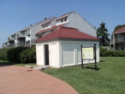
Marker at the Oil House
| 1 ► New Jersey, Atlantic County, Atlantic City — Absecon Lighthouse |
| On S Vermont Avenue, on the left when traveling north. Reported permanently removed. | |||
| 2 ► New Jersey, Atlantic County, Atlantic City — Absecon Lighthouse — |
| On South Vermont Avenue just north of Pacific Avenue, on the right when traveling south. | |||
| 3 ► New Jersey, Atlantic County, Atlantic City — Assistant Keepers’ Dwelling / Chronology — [Absecon Lighthouse] |
| On S Vermont Avenue, on the left when traveling north. Reported permanently removed. | |||
| 4 ► New Jersey, Atlantic County, Atlantic City — Chronology — Absecon Lighthouse — |
| On South Rhode Island Avenue just north of Pacific Avenue, on the right when traveling north. | |||
| 5 ► New Jersey, Atlantic County, Atlantic City — Dedicated to the Men and Women Who Lost Their Lives at Sea — |
| Near North Rhode Island Avenue north of Parkside Avenue, on the left when traveling north. | |||
| 6 ► New Jersey, Atlantic County, Atlantic City — Historic Gardener's Basin — Established July 9, 1976 — |
| On North New Hampshire Avenue, 0.1 miles north of Parkside Avenue, on the left when traveling east. | |||
| 7 ► New Jersey, Atlantic County, Atlantic City — How Chicken Bone Beach Got Its Name — Historic Atlantic City: Missouri Avenue, 1900-1950's |
| On Boardwalk at So. Missouri Avenue, on the right when traveling east on Boardwalk. Reported permanently removed. | |||
| 8 ► New Jersey, Atlantic County, Atlantic City — Jacqueline Mayer — Sandusky, OH — Miss America 1963 — |
| On North Michigan Avenue just north of Atlantic Avenue, on the left when traveling north. | |||
| 9 ► New Jersey, Atlantic County, Atlantic City — Keeper’s Dwelling / Lightkeepers of Absecon Lighthouse — Absecon Lighthouse — |
| On S Rhode Island Avenue, on the right when traveling north. | |||
| 10 ► New Jersey, Atlantic County, Atlantic City — Lighthouse History / Absecon Lighthouse Facts — Absecon Lighthouse — |
| On Pacific Avenue, on the left when traveling east. | |||
| 11 ► New Jersey, Atlantic County, Atlantic City — The Life-Saving Station — Absecon Lighthouse — |
| On S Vermont Avenue when traveling north. | |||
| 12 ► New Jersey, Atlantic County, Atlantic City — The Whaling Bark Stafford — Absecon Lighthouse — |
| On Pacific Avenue at S Rhode Island Avenue, on the left when traveling east on Pacific Avenue. | |||
| 13 ► New Jersey, Atlantic County, Atlantic City — USCS Steamer Robert J. Walker / Assistant Keepers' Dwelling — |
| On South Vermont Avenue at Pacific Avenue, on the right when traveling south on South Vermont Avenue. | |||
| 14 ► New Jersey, Atlantic County, Brigantine — 1 — The Brigantine Lighthouse — |
| On Atlantic Brigantine Boulevard (County Road 638) west of Bayshore Avenue, on the right when traveling west. | |||
| 15 ► New Jersey, Atlantic County, Hamilton, Hamilton Township — Gaskill Park — |
| On River Road (County Road 617) 0.1 miles east of Farragut Avenue, on the left when traveling east. | |||
| 16 ► New Jersey, Atlantic County, Hamilton, Hamilton Township — George Wheaton's Shipyard — Circa 1830-1874 — |
| On Main Street (U.S. 40). | |||
| 17 ► New Jersey, Atlantic County, Hamilton, Hamilton Township — Great Egg Harbor National Scenic and Recreational River — A River to Enjoy and Protect — |
| On River Road (County Road 617) east of Farragut Avenue, on the right when traveling east. | |||
| 18 ► New Jersey, Atlantic County, Hammonton — Ore Boat or Barge — |
| Near Batsto Road, on the left when traveling north. | |||
| 19 ► New Jersey, Atlantic County, Hammonton — Swimming the Ladder to Success — Wharton State Forest — |
| Near Batsto Road, on the left when traveling north. | |||
| 20 ► New Jersey, Atlantic County, Longport — Great Egg Coast Guard Station — 2301 Atlantic Avenue — |
| On Atlantic Avenue just west of South 24th Avenue, on the right when traveling west. | |||
| 21 ► New Jersey, Atlantic County, Longport — High Water Mark — October 29, 2012 — |
| On Atlantic Avenue just west of South 24th Avenue, on the right when traveling west. | |||
| 22 ► New Jersey, Atlantic County, Port Republic — Franklin Inn — |
| On Mill Street, on the right when traveling south. | |||
| 23 ► New Jersey, Atlantic County, Port Republic — Ship’s Rib — |
| On New York Road (U.S. 9) at Chestnut Neck Road (County Route 575), on the right when traveling north on New York Road. | |||
| 24 ► New Jersey, Atlantic County, Somers Point — World War Memorial Bridge — |
| On Stainton Memorial Causeway (New Jersey Route 52) 0.1 miles south of Mays Landing Road, on the right when traveling south. | |||
| 25 ► New Jersey, Atlantic County, Somers Point — World War Memorial Bridge Across Great Egg Harbor Bay — Historical Overview of Transportation — |
| On Stainton Memorial Causeway (New Jersey Route 52) 0.1 miles south of Mays Landing Road, on the right when traveling south. | |||
| 26 ► New Jersey, Atlantic County, Somers Point — World War Memorial Bridge across Great Egg Harbor Bay — Design and Significance — |
| On Stainton Memorial Causeway (New Jersey Route 52) 0.1 miles south of Mays Landing Road, on the right when traveling south. | |||
| 27 ► New Jersey, Atlantic County, Ventnor City — Put On Your Best Suit! — |
| On Boardwalk at South Oakland Avenue, on the right when traveling east on Boardwalk. | |||
| 28 ► New Jersey, Atlantic County, Ventnor City — The Fishing Pier Then & Now — |
| On Boardwalk at South Sacramento Avenue, on the right when traveling east on Boardwalk. | |||
| 29 ► New Jersey, Atlantic County, Ventnor City — Ventnor — 100th Anniversary — |
| On Boardwalk at South Portland Avenue, on the right when traveling east on Boardwalk. | |||
| 30 ► New Jersey, Atlantic County, Ventnor City — Viking Row Club — |
| On South Somerset Avenue just north of Boardwalk, on the right when traveling north. | |||
| 31 ► New Jersey, Bergen County, Edgewater — Burdett's Landing — 1776 — |
| On Annett Avenue. | |||
| 32 ► New Jersey, Bergen County, Edgewater — 68 — Ferryboat Binghamton — |
| On Binghamton Way, on the right when traveling north. | |||
| 33 ► New Jersey, Bergen County, Fort Lee — General George Washington — 1732-1799 — |
| On Palisade Avenue, on the left when traveling south. | |||
| 34 ► New Jersey, Bergen County, Fort Lee — General Henry Knox — 1750-1806 — |
| On Parker Avenue. | |||
| 35 ► New Jersey, Bergen County, Fort Lee — General Nathaniel Greene — 1742-1786 — |
| On Palisade Avenue, on the left when traveling south. | |||
| 36 ► New Jersey, Bergen County, Franklin Lakes — 77 — Franklin Lake — |
| On Franklin Lake Road west of Wyandotte Dr., on the left when traveling west. | |||
| 37 ► New Jersey, Bergen County, Glen Rock — This Bell — |
| On Main Street north of Bradford Street, on the right when traveling north. | |||
| 38 ► New Jersey, Bergen County, Hackensack — Kaiten Type II — (Means = Turned Towards Heaven) — WWII Japanese Suicide Human Torpedo |
| Near River Street at Bridge Street, on the right when traveling north. Reported missing. | |||
| 39 ► New Jersey, Bergen County, Hackensack — PBR Mark II River Patrol Boat |
| Near River Street at Bridge Street, on the right when traveling north. Reported missing. | |||
| 40 ► New Jersey, Bergen County, Hackensack — Seehund — (Means = Seal (Sea-Dog)) — WWII German 2 Man Coastal Defense Submarine |
| Near River Street at Bridge Street, on the right when traveling north. Reported missing. | |||
| 41 ► New Jersey, Bergen County, Hackensack — Still on Patrol — |
| Near River Street at Bridge Street, on the right when traveling north. | |||
| 42 ► New Jersey, Bergen County, Hackensack — Submariners Memorial — |
| Near River Street at Bridge Street, on the right when traveling north. | |||
| 43 ► New Jersey, Bergen County, Hackensack — Talos SAM-N-6 — Ship Launched Surface to Air Missile |
| Near River Street at Bridge Street, on the right when traveling north. Reported missing. | |||
| 44 ► New Jersey, Bergen County, Hackensack — U.S.S. Ling — |
| Near River Street at Bridge Street, on the right when traveling north. | |||
| 45 ► New Jersey, Bergen County, Hackensack — Underwater MK16 Mine |
| Near River Street at Bridge Street, on the right when traveling north. Reported missing. | |||
| 46 ► New Jersey, Bergen County, Hackensack — USS Gudgeon (SS-211) — |
| On River Street at Bridge Street, on the right when traveling north on River Street. | |||
| 47 ► New Jersey, Bergen County, New Milford — 91 — Demarest-Bloomer House — |
| On River Edge Avenue (County Route 70), on the right when traveling west. | |||
| 48 ► New Jersey, Bergen County, North Arlington — Christopher Columbus — 1451 – 1506 — |
| On River Road near Arlington Blvd, on the left when traveling north. | |||
| 49 ► New Jersey, Bergen County, Paramus — Washington Spring — 1780 — |
| On Forest Avenue, on the left when traveling north. | |||
| 50 ► New Jersey, Bergen County, Paramus — 1 — Washington Spring — |
| On Forest Avenue, on the left when traveling north. | |||
| 51 ► New Jersey, Bergen County, River Edge — New Bridge Landing — |
| On Main Street, on the right when traveling east. | |||
| 52 ► New Jersey, Bergen County, River Edge — New Bridge Landing — |
| On Main Street, on the left when traveling east. | |||
| 53 ► New Jersey, Bergen County, River Vale — In Honor Of USS Enterprise (CV-6) — 1938-1947 — |
| Near Rivervale Road. | |||
| 54 ► New Jersey, Bergen County, River Vale — USS Enterprise (CV-6) Stern Plate — |
| Near Rivervale Road. | |||
| 55 ► New Jersey, Bergen County, Rockleigh — 111 — Joseph Dubois House — Built 1835 — |
| On Rockleigh Road near 31 Rockleigh Road, on the left when traveling north. | |||
| 56 ► New Jersey, Bergen County, Rutherford — The Passaic River — |
| On Riverside Avenue at Marginal Road, on the right when traveling north on Riverside Avenue. | |||
| 57 ► New Jersey, Burlington County, Bordentown — An Early Transportation Hub — Delaware River Heritage Trail — |
| On West Park Street just west of Prince Street, on the left when traveling west. | |||
| 58 ► New Jersey, Burlington County, Bordentown — Bordentown — Circa 1850 — |
| Near Farnsworth Avenue (County Road 545) just south of Walnut Street, on the right when traveling south. | |||
| 59 ► New Jersey, Burlington County, Bordentown — British Raid on Crosswicks Creek — |
| On Prince Street near Courtland Street. | |||
| 60 ► New Jersey, Burlington County, Bordentown — Discover Abbott Marshlands: A Natural & Historical Treasure — |
| Near West Park Street west of Prince Street, on the right when traveling west. | |||
| 61 ► New Jersey, Burlington County, Bordentown — 7 — The Crosswicks Creek "Trestle Vessel" — |
| On Farnsworth Avenue at The Waterfront, on the right when traveling north on Farnsworth Avenue. | |||
| 62 ► New Jersey, Burlington County, Bordentown — The Delaware: A National Treasure — Delaware River Heritage Trail — |
| On West Park Street, 0.2 miles west of Prince Street, on the left when traveling west. | |||
| 63 ► New Jersey, Burlington County, Burlington — At Play on the Delaware — The Historic City of Burlington — Burlington Island — |
| On York Street, 0.1 miles north of Pearl Boulevard, on the left when traveling north. | |||
| 64 ► New Jersey, Burlington County, Burlington — Birthplaces — |
| On High Street, on the right when traveling north. | |||
| 65 ► New Jersey, Burlington County, Burlington — Hub of Transportation and Commerce — The Historic City of Burlington-Transportation — |
| On Riverbank Street. | |||
| 66 ► New Jersey, Burlington County, Burlington — The Founding of Burlington — |
| On Riverbank/West Delaware Avenue, 0.1 miles east of Talbot Street, on the right when traveling east. | |||
| 67 ► New Jersey, Burlington County, Delanco — Riverside-Delanco Bridge — |
| On Burlington Avenue (County Route 543) at Rancocas Avenue, on the left when traveling south on Burlington Avenue. | |||
| 68 ► New Jersey, Burlington County, Fieldsboro — Borough of Fieldsboro — Delaware River Heritage Trail — |
| On 4th Street (County Road 622) at Washington Street, on the right when traveling west on 4th Street. | |||
| 69 ► New Jersey, Burlington County, Medford — 7 — Braddock’s Landing — |
| On Mill Street, on the right when traveling south. | |||
| 70 ► New Jersey, Burlington County, Medford — 52 — Decades Ago in Lake Pine — |
| On Taunton Blvd at Falls Road, on the left when traveling north on Taunton Blvd. | |||
| 71 ► New Jersey, Burlington County, Palmyra — Tidal Delaware Water Trail — |
| Near Tacony Palmyra Bridge (New Jersey Route 73) 0.2 miles north of Temple Boulevard, on the left when traveling north. | |||
| 72 ► New Jersey, Burlington County, Riverton — Riverton — New Jersey — Est. 1851 — |
| On Broad Street (County Road 543) at Main Street, on the right when traveling west on Broad Street. | |||
| 73 ► New Jersey, Burlington County, Riverton — Riverton Steamboat Landing — |
| On Bank Avenue at Penn Street, on the right when traveling west on Bank Avenue. | |||
| 74 ► New Jersey, Burlington County, Riverton — Riverton Yacht Club — |
| Near Main Street just north of Bank Avenue, on the right when traveling north. | |||
| 75 ► New Jersey, Camden County, Camden, Central Waterfront — 04 Level Navigation Bridge — Battleship New Jersey — |
| Near Clinton Street west of South Delaware Avenue, on the right when traveling south. | |||
| 76 ► New Jersey, Camden County, Camden, Central Waterfront — 5" Secondary Gun System — Battleship New Jersey — |
| Near Clinton Street west of South Delaware Avenue, on the right when traveling south. | |||
| 77 ► New Jersey, Camden County, Camden, Central Waterfront — Admirals and the Flag Cabin — Battleship New Jersey — |
| Near Clinton Street west of South Delaware Avenue, on the right when traveling south. | |||
| 78 ► New Jersey, Camden County, Camden, Central Waterfront — Admiral's Flag Bridge — Battleship New Jersey — |
| Near Clinton Street south of South Delaware Avenue, on the right when traveling south. | |||
| 79 ► New Jersey, Camden County, Camden, Central Waterfront — Admiral's Flag Bridge — Battleship New Jersey — |
| Near Clinton Street west of South Delaware Avenue, on the right when traveling south. | |||
| 80 ► New Jersey, Camden County, Camden, Central Waterfront — Aiming the Big Guns — Battleship New Jersey — |
| Near Clinton Street west of South Delaware Avenue, on the right when traveling south. | |||
| 81 ► New Jersey, Camden County, Camden, Central Waterfront — Aiming the Secondary Guns — Battleship New Jersey |
| Near Clinton Street west of South Delaware Avenue, on the right when traveling south. Reported damaged. | |||
| 82 ► New Jersey, Camden County, Camden, Central Waterfront — American Merchant Marine Memorial — |
| On Riverside Drive. | |||
| 83 ► New Jersey, Camden County, Camden, Central Waterfront — Battleship New Jersey — |
| On Clinton Street near S. Delaware Avenue, on the right when traveling west. | |||
| 84 ► New Jersey, Camden County, Camden, Central Waterfront — Close-In Weapons System — Battleship New Jersey — |
| Near Clinton Street west of South Delaware Avenue, on the right when traveling south. | |||
| 85 ► New Jersey, Camden County, Camden, Central Waterfront — Eyewitness to History — |
| Near Clinton Street near South Delaware Avenue, on the right when traveling west. | |||
| 86 ► New Jersey, Camden County, Camden, Central Waterfront — 16 — FADM William Frederick Halsey Jr. — New Jersey Hall of Fame — |
| Near Clinton Street west of South Delaware Avenue, on the right when traveling south. | |||
| 87 ► New Jersey, Camden County, Camden, Central Waterfront — Fleet Admiral William Halsey — Battleship New Jersey — |
| Near Clinton Street west of South Delaware Avenue, on the right when traveling south. | |||
| 88 ► New Jersey, Camden County, Camden, Central Waterfront — Harpoon Anti-Ship Missile — Battleship New Jersey — |
| Near Clinton Street near S. Delaware Avenue, on the right. | |||
| 89 ► New Jersey, Camden County, Camden, Central Waterfront — M2 Browning — |
| Near Clinton Street at South Delaware Avenue, on the right when traveling west. | |||
| 90 ► New Jersey, Camden County, Camden, Central Waterfront — Mark 36 Super Rapid Bloom Offboard Chaff (SRBOC) — Battleship New Jersey — |
| Near Clinton Street west of South Delaware Avenue, on the right when traveling south. | |||
| 91 ► New Jersey, Camden County, Camden, Central Waterfront — Ship's Boats — Battleship New Jersey — |
| Near Clinton Street west of South Delaware Avenue, on the right when traveling south. | |||
| 92 ► New Jersey, Camden County, Camden, Central Waterfront — Side View Turret #1 — |
| Near Clinton Street near S. Delaware Avenue, on the right when traveling west. | |||
| 93 ► New Jersey, Camden County, Camden, Central Waterfront — Teakwood Deck Restoration — Battleship New Jersey — |
| Near Clinton Street west of South Delaware Avenue, on the right when traveling south. | |||
| 94 ► New Jersey, Camden County, Camden, Central Waterfront — The Merchant Marine, Liberty Ships and Tankers in World War II — |
| Near South Delaware Avenue south of Dr. Martin Luther King Boulevard, on the right when traveling south. | |||
| 95 ► New Jersey, Camden County, Camden, Central Waterfront — The World's Greatest Battleship! — |
| Near South Delaware Avenue south of Dr. Martin Luther King Boulevard, on the right when traveling south. | |||
| 96 ► New Jersey, Camden County, Camden, Central Waterfront — 15 — Thomas Edison — New Jersey Hall of Fame — |
| Near Clinton Street west of South Delaware Avenue, on the right when traveling south. | |||
| 97 ► New Jersey, Camden County, Camden, Central Waterfront — U.S. Merchant Marine and U.S. Navy Armed Guard — |
| Near South Delaware Avenue south of Dr. Martin Luther King Boulevard, on the right when traveling south. | |||
| 98 ► New Jersey, Camden County, Camden, Central Waterfront — USS New Jersey Aircraft — |
| Near Clinton Street near S. Delaware Avenue, on the right when traveling west. | |||
| 99 ► New Jersey, Camden County, Camden, Central Waterfront — USS New Jersey Marine Detachments — |
| On Riverside Drive. | |||
| 100 ► New Jersey, Camden County, Camden, Central Waterfront — USS New Jersey Marine Memorial — |
| Near Clinton Street west of South Delaware Avenue, on the right when traveling south. | |||
419 entries matched your criteria. The first 100 are listed above. Next 100 ⊳