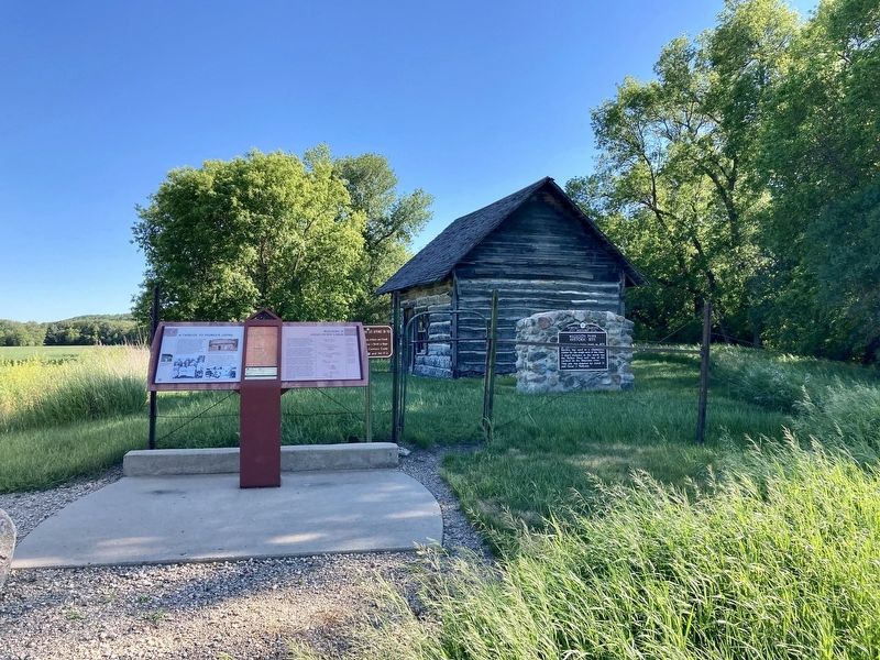
This oak log home built in 1878
by Carl Jensen and his nephew John
Bjerkie was used as a community
center by the single men of the time.
A short distance to the north was
the Walker flour mill, one of the
earliest on the Sheyenne river.
. . . — — Map (db m175433) HM
Walker’s Best
The Walker family, Minnesota emigrants,
had milling in their blood. In 1879, Hiram
Walker established a mill in Valley City.
A few years later, his son Myron took over
and built a new mill at Oakville—he later
bought . . . — — Map (db m177164) HM
The City Park is a peninsula created by an oxbow on the Sheyenne River. Three bridges were built on this oxbow to provide access to the park and for crosstown traffic. The original wooden footbridge, located at this site, was built in 1881, the . . . — — Map (db m242289) HM
The original line of the Northern Pacific Railroad, now the Burlington Northern Santa Fe, descended into Valley City, crossed the Sheyenne River and continued out of the valley. Because of the steep grades, "pusher" engines were required to push . . . — — Map (db m242298) HM
Clustered around the campus of Valley City State University is a unique neighborhood of architecturally and historically significant houses dating from the 1880s to the 1930s. The neighborhood is important for its historical association with Valley . . . — — Map (db m241099) HM
This 1908 steel viaduct across the Sheyenne River Valley allowed the railroad to avoid steep grades. At 3886 feet (1184 meters) long and 155 feet (47 meters) high, it is an excellent example of this bridge type. — — Map (db m242299) HM
Sheyenne River The river was formed by the meltwater of the Wisconsinan glacier about 13,000 years ago. The valley constitutes the glacier's western edge at that time. Flowing 581 miles from its headwaters located 15 miles north of . . . — — Map (db m242287) HM
At 581 miles, the Sheyenne River is the longest in North Dakota. When the Wisconsinan ice sheet melted about 13,000 years ago, it left behind the Sheyenne River and a trench that reaches up to 300 feet deep and a mile wide. Discover historic, . . . — — Map (db m242596) HM
This was the site of one of the largest river warehouses built during the 1870s when river transportation was of primary importance. The warehouse was served by a spur track of the Northern Pacific Railway and until the railroad was built west of . . . — — Map (db m154055) HM
Bullboats, round-bottomed watercrafts, were used by the Mandans, Hidatsas, and Arikaras to transport goods and people
along waterways. Bullboats were indispensable for river traffic and for hauling loads of driftwood for cooking and heating
fires. . . . — — Map (db m164368) HM
Glaciers altered river courses and molded the North Dakota landscape, creating the gently rolling, hilly terrain
seen in most areas of the state today. Prior to about three million years ago, all the rivers in today's North
Dakota flowed toward . . . — — Map (db m164376) HM
Pó is the root for fish in the Mandan language-pótande is the catfish. The Missouri River system, along with its larger
tributaries such as the Heart River, supported fisheries that the Mandans drew upon as part of their subsistence . . . — — Map (db m164371) HM
Apple Creek today is only a mere trickle compared to what it was during the time it was formed from a large sheet of glacial ice. Looking out over the valley one can almost imagine the enormity of this creek during its formation. This . . . — — Map (db m85839) HM
While steamboats delivered and loaded cargo up and down the Red River, recreational use of the Red River blossomed. Sleigh races, ice-skating, skiing, toboganning, and ice fishing provided winter recreation. Boating, swimming, diving, and public . . . — — Map (db m240099) HM
The story of the Red River Valley and Red River of the North began over 11,000 years ago when Lake Agassiz was formed. A glacier extended from Canada south and covered what is now the Red River Valley. As it began to melt and recede northward, . . . — — Map (db m239991) HM
At one time the Red River was home to over a dozen steamboats including the Anson Northup (later renamed the Pioneer), the International, the Selkirk, the Dakota, the Alpha, the Cheyenne, the . . . — — Map (db m239995) HM
Early explorers to the Red River Valley discovered a wide range of wildlife living along the Red River. One could have easily spotted a moose, American elk, mink or even a black bear. Although these animals may be uncommon now, there is a variety . . . — — Map (db m240286) HM
The Maple Creek crossing at old Watson was
probably used as early as 1825 by Selkirk
colonists moving from Pembina area to Fort
Snelling. They were followed in 1843 by the
fur brigades of Kittson and Rolette. Major
Woods crossed here in 1849, . . . — — Map (db m175424) HM
Chelsey and Polly Dinkins played a major role in the construction and operation of this dam and National Wildlife Refuge known as Lake Ilo.
Chelsey Dinkins was the foreman of the Works Progress Administrations (WPA) crew that built the dam in . . . — — Map (db m152944) HM
Considered the Founder of Grand Forks, Alexander Griggs filed the first land plat in the Original Townsite in 1875. Steamboat captain and builder, Griggs was an integral part of the steamboat era. He learned his navigational skills on the . . . — — Map (db m162628) HM
This commemorative plaque is placed near the site where CCC Camp #2760 of the CCC was located in the City of LaMoure, North Dakota--when this Dam was constructed by the CCC in 1934.
CCC Co #2760 built the Dam across the James River just . . . — — Map (db m112158) HM
As printed in the LaMoure County Chronicle Aug. 30, 1912:
"Undoubtedly the most enjoyable trip was the one after supper Sunday evening, when fully half a hundred excursionists found plenty of room on the boat. With the wind reduced to a . . . — — Map (db m112189) HM
One of the earliest forms of Missouri River transportation was the bull boat. Used primarily by the Mandan, Hidatsa, and Arikara tribes, bull boats served as the main watercraft for natives living along the river banks. These boats were both built . . . — — Map (db m235041) HM
To attract shoppers to Washburn from west of the Missouri River, the Washburn Road installed a cable ferry in May 1902, known unofficially as the General Washburn. Cable ferries were small, unpowered boats attached to steel cables stretched between . . . — — Map (db m235089) HM
The first steamboat to reach the upper Missouri was the American Fur Company's Yellow Stone, which arrived at Fort Union in 1832. Nearly 30 years later, steamers began reaching Fort Benton, Montana, the head of navigation on the Missouri. From then . . . — — Map (db m235097) HM
While preparing for the expedition to the Pacific, Meriwether Lewis visited Philadelphia for instructions in natural sciences, astronomical navigation and field medicine. It is believed that it was during this period that Lewis purchased Seaman, his . . . — — Map (db m36352) HM
The last stern wheel ferry on the Missouri. Built by Oscar Anderson in 1951 and operated by him on the Missouri River at Washburn from 1952 to 1962. Restored by the Washburn Bi-centennial Committee in 1976. American Revolution Bicentennial . . . — — Map (db m235096) HM
In 1950 Oscar Anderson, a native of Washburn who had traveled the world since 1917 as an officer in the merchant marine, returned home to spend his retirement years. He found a community that missed its ferryboat connection with the west bank of . . . — — Map (db m235095) HM
The bridging of the Missouri River at Washburn had been a longtime goal for residents of the community. As early as 1908, a party of local residents traveled to Washington, D.C., unsuccessfully, in the interests of such a project. During the 1920s . . . — — Map (db m235047) HM
Construction of the dam began in 1947
and was completed in 1954 at a cost of
$300 million dollars. Garrison Dam is
one of the largest earthen dam structures
in the world with a volume of 66.5 million
cubic yards of rolled earth fill. The . . . — — Map (db m178019) HM
Construction of the Intake
Structure took 5 years and
cost $21 million dollars
back in 1954. Enough
concrete to pave a road
115 miles long was used
in construction of the
structure. The Intake Structure is 249 feet
tall, 540 feet long and . . . — — Map (db m177992) HM
Hydroelectric power is produced
through generating units in the
Powerhouse. The generators
produce electricity at 13,800 volts
which is stepped up to 115,000 and
230,000 volts for transmission. The
rotors on units 1, 2, and 3 are 35 feet
in . . . — — Map (db m178018) HM
With 168 days and 1,600 miles behind them, the Lewis and Clark Expedition arrived near the Knife River Villages. Captain William Clark wrote:
October 27, 1804
"came too at the Village on the L.S. this village is situated on an eminance . . . — — Map (db m33610) HM
Some of the challenges associated with Devils Lake's closed-basin nature is lake level fluctuations. The dramatic lake rise from 1993 to 2011 resulted in tens of thousands of acres of flooded agricultural land, the relocation of hundreds of homes . . . — — Map (db m242768) HM
Situated mostly on Sections 33 and 34, in Township 154, Range 64, Devils Lake was established by H. M. Creel in 1882. Originally known as Creelsburg, Devils Lake was incorporated in 1884 and secured a connection to James J. Hill's great northern . . . — — Map (db m242767) HM
This commemorates the landing of the steamboat ”Minnie H.” built and commanded by Captain E. E. Herman July 4, 1883 Erected by Lakewood Booster Club 1933 — — Map (db m162606) HM
Straight ahead of you and down along the bank
of the river is the approximate location of the ferry
crossing that served Fort Abercrombie.
This photograph shows the ferry as it crosses
the Red River. You are in roughly the same spot
as the . . . — — Map (db m176610) HM
Old maps of the Northwest apply the name of Dakota to the James River. The junction of the
Can Sa Sa (James River) and the Pipestem, where Jamestown is now located, was a favorite place for getting together among the Indians before the . . . — — Map (db m112686) HM
Forman, North Dakota 1884-1954 U.S. Navy An accidental explosion of ammunition occurred on the USS Pittsburgh on July 23, 1917. Commander (then Lieutenant) Bradley, who was about to enter the ammunition storage area, was blown back by the . . . — — Map (db m240630) HM
This monument is a tribute to the people of Minot who endured the worst flood of the Mouse River in the city's recorded history. On this historic day, sirens sounded the signal to more than 11,000 residents to flee their homes from the path of . . . — — Map (db m241098) HM
Irrigation possibilities in the area were recognized as early as 1902. On November 18th, 1904 the Buford-Trenton Project was authorized by the Secretary of the Interior. Reclamation Service (now the Federal Bureau of Reclamation) specifications . . . — — Map (db m143023) HM
... this long wished for spot -- Meriwether Lewis
For many generations, Native peoples came from all directions for the abundant bison and other game, using only seasonal settlements in order to follow migrating herds. As a result this . . . — — Map (db m143014) HM
Thursday and Friday, April 25 and 26, 1805
Rich wildlife heralded the expedition's arrival at the Yellowstone-Missouri confluence. Impatient, Lewis ascended the south bluff to view the "wide and fertile vallies." He camped Thursday . . . — — Map (db m143038) HM
In the nineteenth century, the fastest and easiest means of transport was by water. Riverways linked major United States cities with posts on the frontier. The Missouri and Mississippi Rivers, and their tributaries were highways of commerce to St. . . . — — Map (db m143238) HM
During the historic period, Fort Union's busy deep-water landing was located just below where you are now standing. Riverboats and other vessels tied up here to off-load and on-load passengers and cargo.
Over the years, the Missouri River slowly . . . — — Map (db m143220) HM
The object of you mission is to explore the Missouri river & such principal stream of it, as by its course and communication with the waters of the Pacific ocean, whether the Columbia, Oregon, Colorado, or any other river may offer the most . . . — — Map (db m143239) HM
Captain Lewis
Thursday, April 25, 1805
On the Missouri River, near the entrance of the Yellowstone River
"...I ascended the hills from whence I had a most pleasing view of the country, particularly of the wide and fertile . . . — — Map (db m143037) HM
Sawmill & Water Tower
One of the first projects for the soldiers arriving to build Fort Buford in 1866 was to build a sawmill. By June, 1866, the fort's sawmill was in operation providing sawn planks for building material in the construction . . . — — Map (db m143205) HM