1445 entries match your criteria. Entries 101 through 200 are listed.⊲ Previous 100 — Next 100 ⊳
Non-US Wars Topic
By Dave W, June 30, 2022
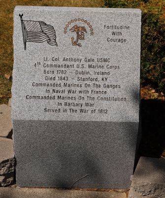
Fortitude with Courage Marker
| 101 ► Kentucky, Lincoln County, Stanford — Fortitude with Courage — Lt. Col. Anthony Gale USMC — |
| On Lancaster Street. | |||
| 102 ► Kentucky, Oldham County, La Grange — Colonel William Oldham — |
| On West Main Street west of South 1st Avenue, on the right when traveling east. | |||
| 103 ► Louisiana, Ascension Parish, Darrow — Bocage Plantation — |
| On River Road (State Highway 942) at St. Elmo Street (Parish Route 1435), on the right when traveling south on River Road. | |||
| 104 ► Louisiana, East Baton Rouge Parish, Baton Rouge, Downtown — Site of Spanish Fort — |
| On State Capitol Drive near North 3rd Street. | |||
| 105 ► Maine, Androscoggin County, Auburn — A10 — Wabanaki History / Les Wabanaquis — Auburn, Maine — The Museum in the Streets® — |
| On Auburn Riverwalk just east of Main Street (Maine Route 136), in the median. | |||
| 106 ► Maine, Aroostook County, Fort Kent — The Aroostook War — |
| On Blockhouse Road at Island Road, on the right when traveling west on Blockhouse Road. | |||
| 107 ► Maine, Cumberland County, Portland, East Bayside — Armenian Genocide Memorial — |
| On Cumberland Avenue just south of Boyd Street, on the right when traveling south. | |||
| 108 ► Maryland, Anne Arundel County, Annapolis — History of Our Maryland Flag — |
| On Maryland Avenue south of Prince George Street, on the right when traveling north. | |||
| 109 ► Maryland, Baltimore, Druid Hill Park — Saving Okapi — |
| Near Silver Spring Drive east of African Journey, on the left when traveling north. | |||
| 110 ► Maryland, Baltimore, Druid Hill Park — William Wallace — |
| On Swann Drive, on the right when traveling north. | |||
| 111 ► Maryland, Baltimore, Inner Harbor — The National Katyń Memorial — Bóg, Honor, Ojczyzna — God, Honor, Country — |
| On President Street at Aliceanna Street, in the median on President Street. | |||
| 112 ► Maryland, Montgomery County, Sandy Spring — Kwame Nkrumah — 09/21/1909 - 04/27/1972 — [Sandy Spring Slave Museum & African Art Gallery] — |
| Near Brooke Road, 0.1 miles west of Chandlee Mill Road, on the right when traveling west. | |||
| 113 ► Maryland, Montgomery County, Silver Spring, Colesville — Khmer Rouge Genocide Memorial — |
| Near New Hampshire Avenue (Maryland Route 650) at Orchard Way, on the left when traveling north. | |||
| 114 ► Maryland, Montgomery County, Silver Spring, Downtown Silver Spring — The Global Refugee Mural — by Joel Beringer ©2009 — creative director Tom Block |
| On Pershing Drive at Bonifant Street, on the left when traveling west on Pershing Drive. Reported damaged. | |||
| 115 ► Maryland, St. Mary's County, St. Mary's City — A Time of Troubles — Struggling — |
| On Middle Street Path just north of Aldermanbury Street Footpath, on the left when traveling north. | |||
| 116 ► Maryland, St. Mary's County, St. Mary's City — In 1648 Margaret Brent Asks for “Vote…And Voyce” — |
| Near Old State House Road at Point Lookout Road (Maryland Route 5). | |||
| 117 ► Maryland, Worcester County, Ocean City — Smaller Conflicts After WWII — |
| On 24th Street just east of Philadelphia Avenue (Maryland Route 528), on the right when traveling east. | |||
| 118 ► Massachusetts, Middlesex County, Cambridge, Harvard Square — Richard T. Greener — Educator, Lawyer, and Diplomat — 1844 - 1922 — |
| On Massachusetts Avenue (Massachusetts Route 2A) south of Church Street, on the right when traveling south. | |||
| 119 ► Massachusetts, Middlesex County, Concord — Concord Massachusetts War Memorials — |
| On Monument Square: Lexington Road. | |||
| 120 ► Minnesota, Brown County, New Ulm — Hermann Monument — (Hermann Denkmal) — |
| Near Monument Street north of Center Street, on the right when traveling north. | |||
| 121 ► Minnesota, Hennepin County, Fort Snelling — Colonel Josiah Snelling — 1782 – 1828 — Soldier · Pioneer · Builder — |
| Near State Highway 55 north of State Highway 5, on the right when traveling north. | |||
| 122 ► Minnesota, Wadena County, Staples — "A Cloud of Barbed Arrows" — |
| Near Old Wadena Circle. | |||
| 123 ► Minnesota, Washington County, Stillwater — Indian Battleground — |
| Near St. Crois Trail North (State Highway 95) 0.1 miles north of Laurel Street East, on the left when traveling north. | |||
| 124 ► Missouri, St. Louis, Forest Park — Threats and Solutions — Going, going, gone? — |
| Near Wells Drive, 0.1 miles west of Concourse Drive, on the right when traveling west. | |||
| 125 ► Missouri, St. Louis, Missouri Botanical Garden — The Symbol of a King — History & Heritage — |
| Near Shaw Boulevard west of Tower Grove Avenue, on the left when traveling west. | |||
| 126 ► Missouri, St. Louis County, Florissant — St. Ferdinand III of Castile — b. 1199 d. 5-30-1252 — |
| On Rue Saint Francois at Saint Ferdinand Street, on the right when traveling west on Rue Saint Francois. | |||
| 127 ► Missouri, St. Louis County, Kirkwood, National Museum of Transportation — #1621 — St. Louis - San Francisco / Eagle Picher — 1918 — |
| Near Barrett Station Road east of Old Dougherty Ferry Road, on the right when traveling east. | |||
| 128 ► Montana, Blaine County, Chinook — We will stand our ground! — Roaring Eagle: tipiyeléhne?iléseniń (George Comedown) — |
| Near Cleveland Road (County Road 240) near S-B Road. | |||
| 129 ► Montana, Chouteau County, Fort Benton — Drowning of the Governor — |
| On Front Street near 17th Street, on the right when traveling north. | |||
| 130 ► Montana, Missoula County, Lolo — Fort Fizzle — |
| Near U.S. 12, on the left when traveling west. | |||
| 131 ► Montana, Missoula County, Missoula — Rankin Hall — |
| On Campus Drive. | |||
| 132 ► Montana, Powder River County, Broadus — Southeastern Montana — |
| On U.S. 212 south of Big Powder River East, on the left when traveling north. | |||
| 133 ► Montana, Rosebud County, Rosebud — The Reno Scout -June 10-19, 1876 — |
| On Rosebud Creek Road (County Road 447) 20 miles south of Interstate 94, on the left when traveling south. | |||
| 134 ► New Jersey, Burlington County, Bordentown — Point Breeze — Estate of Joseph Bonaparte (1768-1844) — Delaware River Heritage Trail — |
| On West Park Street, 0.1 miles west of Prince Street, on the left when traveling west. | |||
| 135 ► New Jersey, Cape May County, Middle Township, Cape May Court House — American Bison — Bison bison — |
| Near County Park Road, 0.3 miles west of North Main Street (U.S. 9), on the left when traveling west. | |||
| 136 ► New Jersey, Cumberland County, Vineland — Sgt. Dominick Pilla — |
| On Cambridge Street at North 6th Street, on the left when traveling east on Cambridge Street. | |||
| 137 ► New Jersey, Mercer County, Trenton, South Trenton — 1655 — |
| On Lamberton Street north of New Jersey Route 29, on the left when traveling north. | |||
| 138 ► New Jersey, Mercer County, Trenton, South Trenton — 1664 — |
| On Lamberton Street north of New Jersey Route 29, on the left when traveling north. | |||
| 139 ► New Jersey, Mercer County, Trenton, South Trenton — 1673 — |
| On Lamberton Street north of New Jersey Route 29, on the left when traveling north. | |||
| 140 ► New Jersey, Mercer County, Trenton, South Trenton — 1817 — |
| On Lamberton Street north of New Jersey Route 29, on the left when traveling north. | |||
| 141 ► New Jersey, Passaic County, Totowa — John P. Holland — "Father of the Modern Submarine" — |
| 142 ► New Mexico, Luna County, Columbus — Pancho Villa’s Raid — |
| 143 ► New York, Allegany County, Scio — Town of Scio — |
| On Main Street (New York State Route 19) 0.1 miles north of Vandermark Road (County Road 10), on the right when traveling north. | |||
| 144 ► New York, Bronx County, Bronx, Bronx Zoo — Père David's Deer Conservation History — |
| Near Jungle World Road south of Bronx River Parkway, on the right when traveling south. | |||
| 145 ► New York, Bronx County, Bronx, Mott Haven — Gouverneur Morris — |
| On Saint Ann's Avenue just north of La Lupe Way, on the right when traveling south. | |||
| 146 ► New York, Broome County, Binghamton — Mohandas K. Gandhi — (1869-1948) — |
| 147 ► New York, Cayuga County, Auburn — The Medal of Honor — USN, USMC, USCG, US ARMY, USAF — |
| On Genesee Street at James Street, on the right when traveling east on Genesee Street. | |||
| 148 ► New York, Chemung County, Elmira — Pulaski Park — Brigadier General Casimir Pulaski — 1748-1779 — |
| On Davis Street at West Center Street, on the right when traveling north on Davis Street. | |||
| 149 ► New York, Dutchess County, Poughkeepsie — Samuel Neilson — |
| 150 ► New York, Jefferson County, Cape Vincent — French Cath. Church — |
| On Dezengremel Road east of County Route 4, on the left when traveling east. | |||
| 151 ► New York, Jefferson County, Watertown — Reactivation and Contingency Operations — |
| On Thompson Park east of Thompson Blvd., on the right when traveling east. | |||
| 152 ► New York, Kings County, Brooklyn, Fort Hamilton — 1916 Easter Rising Memorial Marker — |
| Near 4th Avenue at 96th Street. | |||
| 153 ► New York, Monroe County, Rochester, Charlotte — In Honor of the Crew of USS Liberty — |
| Near Corrigan Street. | |||
| 154 ► New York, Nassau County, East Meadow — The "Comfort Women" — |
| Near Park Boulevard north of County Route 24. | |||
| 155 ► New York, New York County, Manhattan, Central Park South — Simon Bolivar Statue — Central Park South — |
| On 59th Street at Avenue of the Americas, on the right when traveling west on 59th Street. | |||
| 156 ► New York, New York County, Manhattan, Chinatown — 300 — 孫中山先生 [Mr. Sun Yat-sen] — 哥倫布公園 中山廣場 — [Columbus Park Zhongshan Plaza] — |
| Near Mulberry Street south of Bayard Street, on the left when traveling north. | |||
| 157 ► New York, New York County, Manhattan, Chinatown — Biography of Dr. Sun Yat-sen — Father of the Republic of China — (1866-1925) |
| On Baxter Street, on the right when traveling south. Reported permanently removed. | |||
| 158 ► New York, New York County, Manhattan, Chinatown — 301 — Dr. Sun Yat-sen — Dr. Sun Yat-sen Plaza, Columbus Park — |
| On Mulberry Street just south of Bayard Street, on the left when traveling north. | |||
| 159 ► New York, New York County, Manhattan, Chinatown — 301 — Dr. Sun Yat-sen — Dr. Sun Yat-sen Plaza, Columbus Park — |
| On Bayard Street west of Mulberry Street, on the right when traveling east. | |||
| 160 ► New York, New York County, Manhattan, East Village — Margarita Maza De Juarez — |
| On East 13th Street east of Third Avenue, on the left when traveling west. | |||
| 161 ► New York, New York County, Manhattan, Hell's Kitchen — British Aerospace AV-8C Harrier — |
| Near 12th Avenue at West 46th Street, on the right when traveling south. | |||
| 162 ► New York, New York County, Manhattan, Hudson Square — General José Artigas Monument — Soho Square |
| On 6th Avenue at Dominick Street, in the median on 6th Avenue. Reported missing. | |||
| 163 ► New York, New York County, Manhattan, Kimlau Square — Lin Ze Xu — 1785 - 1850 — |
| On Chatham Square at St. James Place, on the right when traveling east on Chatham Square. | |||
| 164 ► New York, New York County, Manhattan, Morningside Heights — Goya — |
| Near Amsterdam Avenue at West 111th Street, on the right when traveling north. | |||
| 165 ► New York, New York County, Manhattan, Washington Heights — El Cid — |
| On Broadway north of West 155th Street, on the left when traveling north. | |||
| 166 ► New York, Saratoga County, Schuylerville — A Native Crossing — Hudson Crossing Park — |
| Near Riverwalk Sensory Trail. | |||
| 167 ► New York, Suffolk County, Shelter Island — Lord Shipyard — |
| On Menantic Road at Lords Lane, on the right when traveling south on Menantic Road. | |||
| 168 ► New York, Warren County, North Creek — Theodore Roosevelt — Citizen Soldier, Steward to the Nation — |
| On Railroad Place, 0.1 miles east of Main Street, on the left when traveling east. | |||
| 169 ► North Carolina, Edgecombe County, Princeville — Historic Princeville — From Slavery to Freedom Hill — |
| On Mutual Boulevard (U.S. 258) west of South Main Street (Business U.S. 64), on the right. | |||
| 170 ► North Carolina, Iredell County, Mooresville — “Lest We Forget that Peace Has a Price” — |
| On South Main Street south of East Central Avenue, on the right when traveling south. | |||
| 171 ► Ohio, Hamilton County, Cincinnati, Avondale — Chalcolithic Age — (circa 4,300 - 3,150 BCE) — |
| Near Vine Street north of Erkenbrecher Avenue, on the right when traveling north. | |||
| 172 ► Ohio, Hamilton County, Cincinnati, Avondale — Hellenistic Peirod — (circa 332 - 37 BCE) — |
| Near Vine Street north of Erkenbrecher Avenue, on the right when traveling north. | |||
| 173 ► Ohio, Hamilton County, Cincinnati, Avondale — Omayyad or Early Arab Period — (circa 650-750 CE) — |
| Near Vine Street north of Erkenbrecher Avenue, on the right when traveling north. | |||
| 174 ► Ohio, Hamilton County, Cincinnati, Avondale — Persian Period — (circa 586 - 322 BCE) — |
| On Vine Street north of Erkenbrecher Avenue, on the right when traveling north. | |||
| 175 ► Ohio, Hamilton County, Cincinnati, Avondale — Roman Period — (37 BCE - 324 BCE) — |
| Near Vine Street north of Erkenbrecher Avenue, on the right when traveling north. | |||
| 176 ► Ohio, Montgomery County, Dayton, Downtown — William J. "Bill" Clinton — Forty Second President of the United States — |
| On West Third Street east of North Ludlow Street (Ohio Route 48), on the right when traveling west. | |||
| 177 ► Ohio, Montgomery County, Dayton, McCook Field — The Peace Plaza — Dedicated July 16, 2003 — |
| 178 ► Ohio, Tuscarawas County, Bolivar — Bolivar — Corporation Limit Marker — |
| On Poplar Street (Ohio Route 212) at Delaware Avenue Northwest, on the left when traveling east on Poplar Street. | |||
| 179 ► Oklahoma, Comanche County, Fort Sill — 691 — Austrian GHN-45 155mm Field Gun/Howitzer — |
| On Corral Road at Randolph Road, on the right when traveling west on Corral Road. | |||
| 180 ► Oklahoma, Comanche County, Fort Sill — South African G-5 155mm Field Gun/Howitzer — |
| On Corral Road at Randolph Road, on the right when traveling west on Corral Road. | |||
| 181 ► Pennsylvania, Bucks County, Morrisville — USS Liberty Memorial — |
| On Lincoln Highway (Pennsylvania Route 32) at South Lafayette Avenue, on the right when traveling east on Lincoln Highway. | |||
| 182 ► Pennsylvania, Cumberland County, Carlisle — Medal of Honor Recipients — Cumberland County, Pennsylvania — Cumberland County Medal of Honor Memorial — |
| On South Hanover Street at West High Street (U.S. 11), on the right when traveling south on South Hanover Street. | |||
| 183 ► Pennsylvania, Erie County, Erie — Meet Erie's New Americans — A Storefront Exhibition — |
| On State Street north of West 5th Street, on the right when traveling south. | |||
| 184 ► Pennsylvania, Erie County, Erie, Harborcreek Township — Elliott Hall — 1987 — |
| Near Jordan Road south of Technology Drive, on the left when traveling north. | |||
| 185 ► Pennsylvania, Lebanon County, Fort Indiantown Gap — M110 Howitzer — |
| On Fisher Avenue at Clement Avenue/Wiley Road, on the left when traveling east on Fisher Avenue. | |||
| 186 ► Pennsylvania, Lebanon County, Fort Indiantown Gap — M113A2 APC — |
| On Fisher Avenue at Clement Avenue/Wiley Road, on the left when traveling east on Fisher Avenue. | |||
| 187 ► Pennsylvania, Lebanon County, Fort Indiantown Gap — M578 LRV — |
| On Fisher Avenue at Clement Avenue/Wiley Road, on the left when traveling east on Fisher Avenue. | |||
| 188 ► Pennsylvania, Lebanon County, Fort Indiantown Gap — M60A3 Patton Tank — |
| On Fisher Avenue at Clement Avenue/Wiley Road, on the left when traveling east on Fisher Avenue. | |||
| 189 ► Pennsylvania, Northampton County, Easton — Nobori, 2010 — Loren Madsen, Laytonville, CA — Carved pine and fir with redwood, purpleheart and walnut inlays and splints — |
| On Karl Stirner Arts Trail, 0.2 miles east of North 13th Street, on the left when traveling east. | |||
| 190 ► Pennsylvania, Philadelphia County, Philadelphia, Fairmount Park — Joan of Arc 1889 — By Emmanuel Frémiet — |
| On Kelly Drive at North 25th Street, on the right when traveling west on Kelly Drive. | |||
| 191 ► Pennsylvania, Philadelphia County, Philadelphia, Fairmount Park — Young Meher (Armenian Monument) — |
| On Art Museum Drive at Kelly Drive, on the right when traveling west on Art Museum Drive. | |||
| 192 ► Pennsylvania, Philadelphia County, Philadelphia, Logan Square — Francisco de Miranda — 1977 — Lorenzo Gonzalez |
| On Winter Street, on the right when traveling east. Reported permanently removed. | |||
| 193 ► Pennsylvania, Philadelphia County, Philadelphia, Logan Square — Francisco de Miranda — Caracas, Venezuela - Cadiz, La Carraca Prison — 1750 - 1816 — |
| On Benjamin Franklin Parkway at Winter Street, on the right when traveling east on Benjamin Franklin Parkway. | |||
| 194 ► Pennsylvania, Philadelphia County, Philadelphia, Logan Square — General Tadeusz Kościuszko — Hero of Poland and the United States of America — |
| On Race Street/Ben Franklin Parkway at North 18th Street, on the right when traveling east on Race Street/Ben Franklin Parkway. | |||
| 195 ► Pennsylvania, Philadelphia County, Philadelphia, Logan Square — 5 — General Tadeusz Kościuszko — 1977 — Marian Konieczny (1930 - 2017) — |
| On North 18th Street at Benjamin Franklin Parkway, on the right when traveling south on North 18th Street. | |||
| 196 ► Pennsylvania, Philadelphia County, Philadelphia, Logan Square — 827 — The Burghers of Calais — Modeled in clay 1884-95; cast in bronze 1919-21 — Please do not touch — |
| Near North 22nd Street north of Benjamin Franklin Parkway, on the right when traveling north. | |||
| 197 ► Pennsylvania, Philadelphia County, Philadelphia, Society Hill — Michael Bouvier — |
| Near South 4th Street south of Locust Street, on the right when traveling south. | |||
| 198 ► Pennsylvania, Philadelphia County, Philadelphia, Washington Square West — Joseph Bonaparte — (1768-1844) — |
| On South 9th Street. | |||
| 199 ► Puerto Rico, Municipio de Cabo Rojo, Cabo Rojo — Cabo Rojo — |
| On Calle Rios Rivera at Calle Barbosa, on the right when traveling east on Calle Rios Rivera. | |||
| 200 ► Puerto Rico, Municipio de Cabo Rojo, Cabo Rojo — Dr. Ramon Emeterio Betances — |
| On Calle Barbosa south of Calle Rios Rivera, on the right when traveling north. | |||
1445 entries matched your criteria. Entries 101 through 200 are listed above. ⊲ Previous 100 — Next 100 ⊳