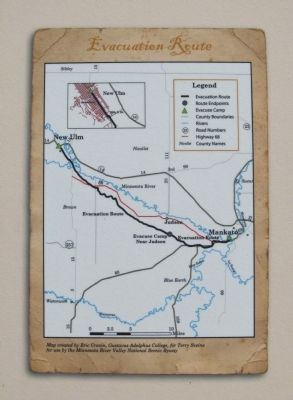
When the Second Battle of New Ulm ended on the morning of August 24, 1862, the city lay nearly in ruins. Fearing that it would surely fall if attacked again, Colonel Charles Flandrau ordered the entire city to evacuate. The next day . . . — — Map (db m73792) HM
This tablet was erected by the Junior Pioneers in memory of the following men, women and children of the town of Milford who were massacred by the Indians during the Indian outbreak in 1862.
John Martin Fink. • Monika Fink, his wife. • Max . . . — — Map (db m67952) WM
Erected by the State of Minnesota in 1929 in the memory of the men, women and children of Milford who were massacred by the Indians, Aug. 18, 1862.
John M. Fink • Monika Fink • Max Fink • Carl Merkle • John B. Zettel • Barbara . . . — — Map (db m67951) WM
In the summer of 1862, after years of broken treaty promises and late payments that fueled growing tensions and conflict, some Dakota began an attempt to forcibly reclaim their homeland. After attacking the Redwood (Lower Sioux) Agency . . . — — Map (db m67915) HM WM
This memorial is dedicated to the memory of John Armstrong pioneer of Linden Township, in 1857 he represented this part of Brown County as its first Territorial County Supervisor (Commissioner) and later became Linden Township's first . . . — — Map (db m68083) HM
The Sioux Indians called this lake "minne hanska," meaning "long water." The basin of the lake was formed 11,000 to 15,000 years ago by the Wisconsin glacier; the original hard clay bottom is now about 50 feet below the present surface of the . . . — — Map (db m66454) HM
This log cabin was built about 1857 by the Omsrud/Thordson and Torgrimson families, immigrants from Valdres, Norway. It originally stood on the Thord Omsrud farm on the shores of Omsrud Lake. The cabin was moved to this site in 1986 by . . . — — Map (db m66437) HM
In 1857, settlers platted a townsite in Section 14 of the Leavenworth area. During the next year, Dr. J. B. Calkins established the post office and became its first postmaster. Leavenworth Township was legally organized on April 16, 1859. Seven . . . — — Map (db m68025) HM
The Joseph Brown family with son Jonathan and daughter Oratia were early settlers on a farm five miles west of here along the Shetek Trail. The family fed and over-nighted guests, operating their home as a traveler's inn. Upon hearing news of Dakota . . . — — Map (db m67825) HM
Following the outbreak of hostilities between the Dakota and white settlers on August 18, 1862, hundreds of people fled from nearby farms to New Ulm for safety. Quickly, Brown County Sherriff Charles Roos and Jacob Nix, a citizen with German . . . — — Map (db m73140) HM
Brown County, an historic gateway on the Minnesota River, opened the fertile prairie lands of the Great Plains to the northern hardwoods of a continental divide. The U.S. Territorial Legislature organized the county in 1856 from lands ceded by the . . . — — Map (db m66749) HM
Rosa Schnobrich opened the City Meat Market in 1907 with the advertising slogan, "Better Meats, Cleaner Meats, and Quicker Service." Her sausages, in particular, proved popular, and soon her shop began supplying a network of wholesale dealers . . . — — Map (db m68267) HM
Colonel Wilhelm Pfaender (1826-1905), born in Heilbronn, Wurttemberg, Germany, came to America as a result of the 1848 Revolution. In Germany he helped found the Turner Societies in his birth-city of
Heilbronn and in Ulm. In Cincinnati, Ohio, he . . . — — Map (db m73673) HM
The Dacotah House, located on this site, was built in 1859 by Adolph Seiter and Frank Erd. Adolph's wife, Helena Erd Seiter soon established her fame in the kitchen. During the Dakota Conflict of 1862, Helena fled in a wagon with her children to . . . — — Map (db m66377) HM
This monument is erected by the State of Minnesota to commemorate the battles and incidents of the Sioux Indian War of 1862, which particularly relate to the town of New Ulm.
1890.
Honored be the memory of the citizens of Blue Earth, Nicollet, . . . — — Map (db m66990) HM WM
Frank Erd and his wife, Louise, came to New Ulm from Cincinnati. Frank, whose father was an architect, erected a substantial store, one of the few brick buildings in the city. The Brown County supervisors kept their offices in Erd's building, . . . — — Map (db m66897) HM
Valentine Sommereisen was the first resident Catholic priest in three large areas of the American West: southwestern Minnesota, the Dakota Territory, and western Kansas. Born 28 May 1829 in Rouffach, Alsace, a German–speaking part of eastern . . . — — Map (db m74222) HM
The second battle of New Ulm took place on August 23, 1862. About 650 Dakota Indians surrounded the town, while over 2,000 people were crowded behind a barricade. The attack began around nine in the morning and the Dakota Indians quickly encircled . . . — — Map (db m66402) HM
Frederick Forster came to the United States in 1850 and taught school in New York. He moved to New Ulm in 1858, where he continued teaching, becoming the city's postmaster in 1861.
In 1860, Forster purchased this lot and the following . . . — — Map (db m68227) HM
The first structure built on this site was the Minnesota Haus, the first hotel in New Ulm, built in 1856 by Phillipp H. Gross. That early structure was destroyed and in 1860, on the same sight, Gross built the Union Hotel, a two and a half story . . . — — Map (db m67981) HM
By the end of the fighting in New Ulm, the U.S.—Dakota War of 1862 had taken a heavy toll on the town. More than 50 settlers had been killed and 36 wounded, along with an unknown number of Dakota. In addition, at least 190 of the . . . — — Map (db m74136) HM
Jacob Nix from Bingen Am Rhein in Germany was a key figure in the defense of New Ulm in 1862. Born in 1822, Nix early joined the push for a united Germany under a republican form of government. During the ill-fated 1848 Revolution, Nix served as . . . — — Map (db m65455) HM
The Kiesling House is one of the three downtown buildings in New Ulm to survive the Dakota War of 1862. Frederick W. Kiesling, blacksmith and ferrier, had built the modest frame house ($125) the year before the outbreak of the war. In August of . . . — — Map (db m65497) HM
During the Minnesota Sioux Uprising of 1862, eighteen men left New Ulm early on the morning of August 19, and travelled westward about 20 miles along the Big Cottonwood River to the area of Leavenworth. Searching for relatives and friends, they . . . — — Map (db m65486) HM WM
east side
In memory of our honored brave who fell in defence of The Union.
north side
In memory of those who fell in defence of New Ulm 1862.
west side
In memory of those massacred by the Indians in Brown Co. . . . — — Map (db m68705) WM
While crossing this ravine a
recruiting party of the Civil War
was ambushed by the Sioux
Indians on August 18th, 1862, at
the noon hour.
The following were killed or
mortally wounded:
John Schneider • Ernest Dietrich . . . — — Map (db m73704) HM WM
On this site in 1859 Frederick Roebbecke built a seventy foot high wooden windmill for grinding corn and grain. Situated on a prominent ridge, it commanded an excellent view of the scattered settlement. Barricaded with sacks of flour and grain, the . . . — — Map (db m65400) HM
To pay homage to the sturdy pioneers who founded the territory of Minnesota a century ago. And to express veneration for the pioneers of Brown County and members of their families who lost their lives during the Sioux War of 1862 — 1863. . . . — — Map (db m73642) HM WM
The first news of the Sioux Uprising was brought to New Ulm at noon on August 18, 1862, by survivors of a Civil War recruiting party that had been ambushed in Milford Township. Barricades were hastily erected in a three-block area on Minnesota . . . — — Map (db m65402) HM
Henry A. Subilia, a native of Jean, Italy, constructed the Waraju distillery in 1861. The construction cost total of $8,000, plus $2,000 for furnishings. The building required approximately 200,000 bricks and measured 72 feet x 46 feet. It obtained . . . — — Map (db m153916) HM
In the summer of 1851 the Dakota Indians, a group of Native Americans who lived in Southern Minnesota, sold their land, 35 million acres, to the United States for $3,000,000. The Dakota agreed to move to a reservation which included land ten miles . . . — — Map (db m67983) HM
In the 1850s there was a land boom in southern Minnesota. Jonathan Brown, 37 years old, filed on land along the Cottonwood River in what is now Burnstown Township. (S 1/2 of SW 1/4, Sec. 15; N 1/2 of NW 1/4 of Sec. 22)
Jonathan picked a good . . . — — Map (db m67820) HM
Watertown is one of the oldest settlements in Minnesota’s south central region. Chief Little Crow of the Dakota Nation and his tribe often camped by the Crow River. At first the Chief and the settlers trusted each . . . — — Map (db m213030) HM
On Leech Lake, Bugonaygeshig is celebrated as a symbol of resistance by both the Indian and white communities. He lived a long life, steadfast in his Indian ways and Bugonaygeshig School in Bena, MN is named in his honor. On September 15, 1898, he . . . — — Map (db m235754) HM
When a federal marshal with about 100 troops of the 3rd Infantry tried to arrest the Chippewa Chief Bugonaygeshig at Sugar Point opposite here on the northeast shore of the lake, a sharp fight occurred October 5, 1898. The whites lost 7 killed and . . . — — Map (db m124726) HM
"What is old is not good.
What is new is good.
Think only on the new.
In that way, by degrees
you will be able to attain
something. That is the way.
Among other peoples beyond
ours, men consider that alone....
The Dakotas are getting . . . — — Map (db m176416) HM
Tokanne (Mary Little Crow Renville) (1789-1840) was born a Kaposia
Bdewakantuŋwan toward the end of the 18th century when tribes
throughout the Midwest were actively developing kinship alliances via
marriage into the Canadian fur trade . . . — — Map (db m176989) HM WM
The establishment of Fort Ripley in 1848 represents the U.S. government’s effort to establish control on the northern frontier. Construction began on the west bank of the Mississippi River across from this point a year before Minnesota became a . . . — — Map (db m43935) HM
Here on the Mendota Trail from 1839 to 1852 stood the Sioux village of the Little Crow family. An attempted Chippewa attack in 1842 precipitated the Battle of Kaposia across the river. After the Treaty of Mendota in 1851 the band moved up the . . . — — Map (db m31186) HM
Osakis was one of the stops on the Burbank Minnesota Stage Company Line to the Red River, established in the spring of 1859 upon the opening of the Fort Abercrombie Military Road. During the Sioux outbreak of 1862 the maintenance of this line of . . . — — Map (db m157797) HM
Many Dakotas consider the Minnesota River Valley to be their spiritual home. The Dakota Indians were the last group of native peoples to live in the valley near this site. Starting in the mid-1600s, they migrated here in successive waves from the . . . — — Map (db m117487) HM
In the 1830s and 1840s Christian Missionaries came into Indian Country, which included Bloomington, with the purpose of converting Dakota Indians to Christian beliefs and white person's ways. This included farming, owning property, receiving a . . . — — Map (db m117572) HM
Listed below are some of the most prominent missionaries to the Dakota Indians. These missionaries were sponsored by the American Board of Commissioners of Foreign Missions, a joint venture of the Presbyterian and Congregational Churches of America. . . . — — Map (db m117630) HM
A critical moment of the US–Dakota War took place a few steps away from here on November 11, 1865, with the execution of Dakota leaders Sakpedan and Wakan Ozanzan. Drugged and kidnapped from their refuge in Canada, the two leaders faced trial by a . . . — — Map (db m229040) HM
Following the Battle of Wood Lake, 1,600 Dakota, mostly women and children, were forced to march from Camp Release to Fort Snelling. Rather than take up arms, many Dakota had protected white settlers and captives during the war. Arriving on . . . — — Map (db m229258) HM
The US-Dakota War of 1862 was a violent and divisive period in Minnesota history. Between 1837 and 1858, the Dakota nation signed treaties transferring more than 24 million acres of land to the United States, only to find agreed upon payments . . . — — Map (db m227894) HM
This memorial honors the sixteen hundred Dakota people, many of them women and children, who were imprisoned here at Fort Snelling in the aftermath of the 1862 U.S.-Dakota Conflict. Frightened, uprooted, and uncertain of the fate of their missing . . . — — Map (db m227845) HM
Erected by the State of Minnesota
in the year 1909, to the memory of the pioneer setters of Jackson County, whose names are inscribed below, massacred by the Sioux Indians on March 26th, 1857, and August 24th, 1862.
1857 Massacre
William . . . — — Map (db m205190) HM
Olson Slaabakken Cabin
Emmet Olson donated this cabin to the city of Jackson in 1926. The cabin is said to have been the first cabin occupied by the family of Engebret Olson when they arrived in Jackson County in 1860. He said that he traded a . . . — — Map (db m205193) HM
This cabin was donated by
Emmet Olson
in 1927 to this park.
Built prior to 1860, the cabin was the home of these Norwegian settlers who underwent the Indian massacre of Aug. 24, 1862, in Belmont Twp. north of Jackson. Sioux raiders . . . — — Map (db m205191) HM
At the start of the U.S.-Dakota War of 1862 settlers around Columbia (now Spencer) hastily formed an oxcart train and started for the stockade at Forest City. On the way to Diamond Lake, the refugees ran into other settlers fleeing from the Eagle . . . — — Map (db m77228) HM
After fighting a running battle with the Dakota on August 20, 1862 at Diamond Lake, two groups of refugees from Spicer and Eagle Lake camped here at Wheeler's Lake. The Dakota camped across the lake from them. There were no disturbances during . . . — — Map (db m77273) HM
Captain John S. Cady ambushed by Indians from this spot June 11, 1863.
Following the suppression of the Dakota (or Sioux) Uprising of 1862 the Eighth Minnesota Volunteer Regiment patrolled the frontier from Hutchinson to the Red River. Captain . . . — — Map (db m231708) HM
Immediately following the U.S.-Dakota Conflict of 1862, the United States Army established a chain of small military posts to stabilize the nearly abandoned frontier by keeping everyone—Dakota and settlers—out of the area. Temporarily mounted for . . . — — Map (db m231704) HM
What is believed to be one of the last pitched battles between the Ojibwe and Dakota ended near this marker about 1860. Some Dakota hunters found a party of Ojibwe encroaching on Dakota grounds. They attacked, killing several Ojibwe and driving the . . . — — Map (db m78413) HM
John Other Day, a Dakota who disagreed with the decision to go to war with the Whites, led a party of sixty-two white men, women and children out of danger when the Dakota attacked the Upper Sioux Agency near Granite Falls. The party left the Agency . . . — — Map (db m76656) HM
The United States Army responded to the U.S. - Dakota War of 1862 by carrying out federal government security policies of removing remaining noncombatant Dakota people and pursuing combatants while protecting settled areas. In August 1863, Jesse V. . . . — — Map (db m78292) HM
During the Dakota Conflict of 1862, there were no casualties among the Norway Lake community settlers, although several from the nearby West Lake community were killed. On August 20, survivors from West Lake and other settlers from the Norway . . . — — Map (db m75746) HM
This Monument is Erected by the
State of Minnesota,
in Memory of
Anders Petter Lundborg,
born Mar. 23, 1837.
Gustof Lundborg, born Apr. 30, 1839.
Lars Lundborg, born Dec. 22, . . . — — Map (db m78140) HM WM
Rev. Andrew Jackson had two services arranged in his Norway Lake Swedish Lutheran Parish for Wednesday, the 20th of August, 1862. In the forenoon a meeting was held at the Lundborg cabin at West Lake, now known as Monson Lake in Swift County. Here a . . . — — Map (db m79405) HM
The United States Army responded to the U.S.-Dakota War of 1862 by carrying out federal government security policies of removing remaining noncombatant Dakota people and pursuing combatants while protecting settled areas. In September 1862, . . . — — Map (db m231763) HM
The settlers of Roseville Township fled to Richmond when they heard of Dakota attacks in Kandiyohi County in 1862. When some time had passed without reports of Dakota in the Roseville area, a party consisting of John, Hugh and Robert Blakely, Hugh . . . — — Map (db m231764) HM
After the attack at the Lower Sioux Agency near Morton, twenty-five to thirty Dakota warriors camped here on August 18, 1862 en route to the lake settlements in Kandiyohi County. The Dakota in this party had frequently hunted in the lake region and . . . — — Map (db m231700) HM
On September 28, 1858, Johannes and Carin Iverson and family settled on section 32 of Lake Andrew Township near Crook Lake. Using supplies from the Eagle Lake Sawmill, Johannes Iverson built a log house here.
Almost four years later, on August . . . — — Map (db m79375) HM
The Dakota nation established campsites in Kandiyohi County to hunt and fish. Little Crow's campsite located here was used for that purpose. Little Crow was born Taoyateduta about 1810 in the Mdewakanton Dakota village of Kaposia. Little Crow later . . . — — Map (db m78384) HM
In May 1859, Olof Olson Haugen, his wife Bergeret, and son Frederick homesteaded here in section 32, Dovre Township. Over the next three years, the Haugen family diligently worked to establish their new life; building shelter, raising crops and . . . — — Map (db m77770) HM
Ojibwe and Dakota nations had a long history of conflict in what would become Minnesota. Both Dakota and Ojibwe people contended for the control of the abundant natural resources in the future Kandiyohi County area that played an economic role in . . . — — Map (db m78028) HM
On August 20, 1862, Andrew Jackson, a circuit-rider minister, was conducting services for members of the New Sweden Church (Lebanon Lutheran) at the Lundborg family cabin at this site. Young Peter Broberg interrupted to tell his parents that . . . — — Map (db m77823) HM
A Response To Conflict
In 1865, a military post was established here in response to the U.S.-Dakota Conflict of 1862. During the conflict, twenty-five settlers and an unknown number of Dakota were killed in what is now Kandiyohi . . . — — Map (db m76774) HM
Berger Thorson was the first resident of what is now the city of Willmar. Little is known of the man except that he raised cattle and sometimes herded cattle for other settlers. On August 20, 1862 a Dakota war party surprised him near his cabin and, . . . — — Map (db m231826) HM
Solomon and Adaline (Stocking) Foot, with their four children, were the first settlers in Willmar Township, at this site in 1857. (Nearby Foot Lake was named after them.) Ground was broken in the spring. Vegetables, grain, and corn were planted. At . . . — — Map (db m231806) HM
This monument has been placed to honor Guri Endresen-Rosseland and other early settlers of the Solomon Lake community. The settlers were predominately immigrants from Hardanger, Norway. Among the special characteristics of these pioneers were . . . — — Map (db m75661) HM
In May 1859, Olof Olson Haugen, his wife Bergeret, and son Frederick homesteaded here in section 32, Dovre Township. Over the next three years, the Haugen family diligently worked to establish their new life; building shelter, raising crops and . . . — — Map (db m77735) HM
The first native Americans came to what is now Kandiyohi County about 10,000 years ago, to hunt mammoths and other huge prehistoric animals.
As the environment changed over the years, so did the Indians. They became less dependent on . . . — — Map (db m76235) HM
Robbins Island was formed about 25,000 years ago during the Wisconsin glaciation period. Early people used it as a refuge from prairie fires and their enemies. Artifacts, including a copper projectile point about 3 thousand years old, have been . . . — — Map (db m76867) HM
A Congregation & the Conflict
Kandiyohi County's first church once stood near here. Housed in an abandoned log cabin, the first congregation gathered in 1859 to hold its services. The congregation was called New Sweden and later became . . . — — Map (db m231773) HM
Home to an Historic Battle
The Erickson Cabin was the site of a battle during the U.S.-Dakota Conflict in 1862. This outbreak of violence occurred at a time when tension between Dakota tribal members and the U. S. Government had reached . . . — — Map (db m231774) HM
This log house is one of our state's Norwegian-American treasures. It was built about 1858 for the Endreson family, who had emigrated from Vikoy parish, Hardanger, Norway, in 1857.
Lars Endreson Rosseland, the builder of the house, had been a . . . — — Map (db m231777) HM
On September 26, 1862, 91 whites and about 150 mixed-blood captives, some of whom had been prisoners of the Dakota Indians for more than a month, were returned to Colonel Henry H. Sibley's military camp, later joyfully known as Camp Release. In the . . . — — Map (db m69118) HM
On September 26, 1862, the 270 men, women and children taken captive by the Dakota during the war were released to military commander Henry H. Sibley at this site, known from that time on as Camp Release.
Years later at the . . . — — Map (db m71384) HM
Experience showed Dakota Chief Maza śa (Red Iron) that it did little good to stand in the way of the U.S. government. He had opposed the 1851 Treaty of Traverse des Sioux but, in the end, had little choice when he and other Dakota . . . — — Map (db m164642) HM
Just two days after the captives were turned over, the brief military trials of the Dakota who had taken part in the fighting began here at Camp Release on September 28, 1862. The trials moved to the Redwood (Lower Sioux) Agency on . . . — — Map (db m71437) HM
Le Sueur Tigers No. 1, William Dellaughter, commander
I. Allen,
E. Bacon,
A. Bangs,
H. Bridenthall,
B. Birdsall,
J. Birdsall,
P. Burch,
N. Burgers,
L. Butman,
F. Butteauz,
S. Carpenter,
W. Case, J. Coggswell, G. Cook, B. Cosly, . . . — — Map (db m65705) HM WM
This boulder marks the site of
Fort Fairmount
Built during the Sioux Indian Uprising
1862
By Co. A 25th Wisconsin volunteers under Major Jeremiah M. Rusk
and is
dedicated to the pioneers
who faced the dangers of frontier life . . . — — Map (db m205059) HM
Known also as Chain of Lakes post, was a substantial log stockade of the present Martin County court house grounds.
It was built in September 1862 for defence against the Sioux and was garrisoned by volunteers and troops of the 25th . . . — — Map (db m205131) HM WM
About 1200 feet north-east of this point stood the pioneer log cabin of Samuel White.
There on September 22, 1862, Samuel and his wife Laura, and two children, Susan and Otis were brutally murdered by a small party of Sioux Indians . . . — — Map (db m69995) HM WM
He fought for the Indian's right
to live in peace in this land.
Gift · Mr. & Mrs. Les Kouba · 1982
Erected 1937
The red of the sunset upon these waters reminds us that all blood is red--even that of the red-skin who fought us for . . . — — Map (db m71120) WM
This tablet marks the site of a stockade built by the Settlers Of Hutchinson And Vicinity For Protection Against The Sioux Indians. Sept. 4, 1862, Chief Little Crow's band attacked the stockade and was repulsed. Erected October 4, . . . — — Map (db m70048) HM
During the U.S. – Dakota War, a battle between Dakota soldiers led by Taoyateduta or Little Crow and Tunkanhnamani (Walks Under A Sacred Stone) and Co. B, 9th Minn. Inf. Regt. made up of new recruits and civilians led by Capt. Richard Strout, . . . — — Map (db m70617) HM
On September 3, 1862 during the Sioux Uprising the citizens of Forest City erected upon this site a stockade for the defense against Indians. Early next morning, soon after some 240 people had taken refuge there, the stockade was attacked. The . . . — — Map (db m74620) HM
This marks the spot where the first blood was shed in the Sioux Indian Outbreak Aug. 17, 1862
Victims: Robinson Jones • Ann Baker-Jones • Howard Baker • Viranus Webster • Clara D. Wilson
Bodies of these Victims are buried in Ness . . . — — Map (db m70373) HM WM
On August 17, 1862, four young Dakota hunters, returning to their hungry families from an unsuccessful hunt, argued about stealing food from white settlers. Sungigidan, Kaomdeiyeyedan, Nagiwicakte, and Pazoiyopa dared each other this: who among . . . — — Map (db m70357) HM