On South Main Street (Business Kentucky Route 127) at East Court Street, on the right when traveling north on South Main Street.
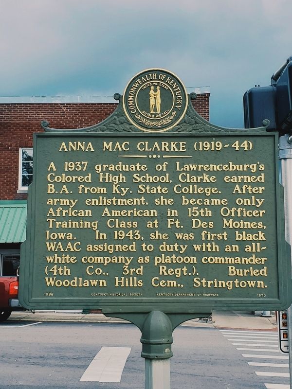
This Lawrenceburg native was one of the first black women in Ky. to enlist during World War II. She joined Women's Army Auxiliary Corps in 1942, and was commissioned a 1st Lieutenant the next year in newly named Women's Army Corps. While . . . — — Map (db m229583) HM
On Washington Street / South Public Square at South Race Street, on the right when traveling east on Washington Street / South Public Square.
Born in Hiseville (Barren Co.). Graduate of Kentucky State Univ.; later member of Board of Regents. Also studied at Indiana Univ. and Peabody Coll. As principal of Ralph J. Bunche School, Twyman led its merger with Glasgow High School to achieve . . . — — Map (db m82469) HM
On Race Street at Washington Street, on the left when traveling south on Race Street.
This Glasgow native was the first African American woman to earn a pilot’s license in the U.S., 1937. That year, she also earned masters degree from Northwestern Univ. She was first African American officer in Civil Air Patrol (1941) & first . . . — — Map (db m88118) HM
On Center Street at Girard Street, on the right when traveling north on Center Street.
First Baptist African American
Church in Florence was founded
in 1870 by the Trustees of the
Colored Baptist Association. The
congregation was active for over
100 years and was essential to
formerly enslaved people & Freedmen
in the area. . . . — — Map (db m180718) HM
On Russell Cave Road (Kentucky Route 353) 0.1 miles south of Centerville Lane, on the left when traveling south.
Established in 1867 under Rev. Thomas Gant after members left the fellowship of First Baptist Church, Paris, Rev. Elisha Green, pastor. Current church structure of wood mold brick built in 1904. Membership includes descendants of the original . . . — — Map (db m170051) HM
On Main Street north of East 5th Street, on the right when traveling north.
Born in Millersburg, Kidd devoted much of her life to civil rights causes. Served as representative in Ky. state legislature, 1968-85, earning her nickname, “Lady of the House.” Kidd led Ky.'s ratification of 13th, 14th, and 15th amendments to . . . — — Map (db m123690) HM
On Winchester Street (Kentucky Route 627) at Vine Street, on the right when traveling south on Winchester Street.
Sites of birthplace of Garrett A. Morgan, and Branch School, which he attended, are ¼ mile south. He invented the tri-color traffic signal, forerunner of the present type, and a gas mask worn in rescue work at Cleveland, Ohio, 1916. His mask was the . . . — — Map (db m170056) HM
On 15th Street at Greenup Avenue (Kentucky Route 23), on the left when traveling north on 15th Street.
The Booker T. Washington School was built in 1903 for grades 1-8. By 1931 it included a four year high school at its Central Ave & 7th ST location. All Boyd Co. schools were not integrated until 1962. In that year, Booker T. Washington closed. We . . . — — Map (db m228066) HM
On Central Avenue at 8th Street, on the left when traveling west on Central Avenue.
In 1894 Ashland Board of Education assumed management of “Negro School,” where African American William Reynolds was principal. In 1901 a bond issue passed with support of blacks and Superintendent J.G. Crabbe. School board then funded . . . — — Map (db m127190) HM
In this block a thriving African American business district stood for over 100 years. Restaurants, barber and beauty shops, medical and dental offices, and retail shops drew patrons from Boyle and nearby counties. Until razed by urban renewal in . . . — — Map (db m49741) HM
Physician & teacher spoke here at 1887 State Assoc. of Colored Teachers Meeting advocating women's suffrage. Speech in national newspaper. — — Map (db m132656) HM
On 2nd. Street south of Main Street, on the left when traveling south.
May 23, 1864, nearly 250 black men, most of them slaves, left Boyle Co. to march to Camp Nelson in Jessamine Co. to enlist in the Union army. On the way, some Danville citizens threw stones and shot pistols at the recruits. When they reached . . . — — Map (db m70996) HM
On Stanford Ave (Kentucky Route 150), on the left when traveling north.
Side 1 Original site of Bate High School, built 1912 and named in honor of its founder, John William Bate. Born a slave in Louisville, Bate received an AB from Berea College in 1881 and and AM in 1891. He moved to Danville to teach in 1881 . . . — — Map (db m105414) HM
On East Walnut Street, on the right when traveling east.
Willis Russell, a well-educated & emancipated slave of Rev. War captain Robert Craddock, relocated from Warren Co., Ky. to Danville around April 1838. He taught black children in this pre-1795 log home that he inherited when Capt. Craddock died in . . . — — Map (db m121564) HM
On Heather Renee French Boulevard (Kentucky Route 8) at Frankfort Street, on the right when traveling west on Heather Renee French Boulevard.
Stephen Collins Foster, as youth, visited here, May 1833. His uncle, Dr. Joseph S. Tomlinson, was then President of Augusta College. The musical, harmonious voices from the old Negro church on the hill floated softly over the town. “It can . . . — — Map (db m136271) HM
On Bridgeville Road (Kentucky Route 875) south of Brooksville-Germantown Road (Kentucky Route 10), on the right when traveling south.
John Gregg Fee. Fee received degree from Augusta
College; went to Lane Theological
Seminary. Had spiritual experience
which began career as nationally
known and determined abolitionist.
A founder of Berea College who
wanted low-cost . . . — — Map (db m136344) HM
On Little Muddy Church Road at Bowling Green Road (U.S. 231), on the left when traveling east on Little Muddy Church Road.
Front
Settled ca. 1800 by Rev. War veterans Thos. Carson, John Helm, & Matthew Kuykendall who received land grants for their service. These founders of Butler County served as first county surveyor, presiding justice of . . . — — Map (db m123286) HM
On North Donnivan Street at Calvert Street, on the right when traveling north on North Donnivan Street.
In 1910, Princeton High School was the only high school in the vicinity for blacks. In 1920s name was changed to Dotson High School in honor of John Dotson, a prominent black businessman in Princeton. In 1938, Federal WPA officials approved . . . — — Map (db m166066) HM
Near North 15th Street at Olive Boulevard, on the left when traveling north.
Shortly after the historic U. S. Supreme Court Brown v. Board of Education, et. al. decision, Murray State College "with all deliberate speed," welcomed Mary Ford Holland of Kuttawa, Ky., as a student in the summer of 1955. Holland's . . . — — Map (db m179582) HM
Near Fort Heiman Road, 0.6 miles east of Kline Trail, on the left when traveling east.
Fort Heiman, in which you are standing, was built almost entirely by slaves from Mississippi and Alabama. Slaves, as well as white laborers pressed into Confederate service, helped to build all three forts guarding the Tennessee and Cumberland . . . — — Map (db m173046) HM
On Washington Avenue south of East 5th Street, on the right when traveling south.
Robert Percell “H-Bomb” Ferguson started his colorful Jump Blues career as pianist & Blues shouter the “Cobra Kid”, recording with Jack “The Bear” Parker's orchestra in early 1951. He became “H-Bomb” later that year when he joined Savoy Records and . . . — — Map (db m187604) HM
On East Southgate Street east of Saratoga Street, on the left when traveling east.
In 1870, the Newport City Council purchased property for a school for African Americans, and three years later a frame house was constructed. Elizabeth Hudson was appointed first African American teacher at salary of $35 per month. Two major events . . . — — Map (db m135078) HM
Theodore Roosevelt Poston was born on July 4, 1906, in Hopkinsville. He was a graduate of Attucks High School and Tennessee A&I State College. In 1936 he began freelance writing for the New York Post and was soon hired full-time. He retired in . . . — — Map (db m105693) HM
On Boonesboro Road (Kentucky Route 627) at Old Stone Church Road, on the right when traveling south on Boonesboro Road.
Daniel Boone attended, Squire, Jr., Samuel, and Mary Boone baptized here. Church name changed, 1790, from Howard's Creek to Providence. William Bush, a member of Boone's second Ky. expedition, built the present stone structure of native limestone. . . . — — Map (db m30831) HM
On Courthouse Square at North Main Street, on the left when traveling south on Courthouse Square.
Side 1:
In 1811, John Coe (1784-1854), arrived in Cumberland County with at least 3 people he enslaved. They grew dark tobacco, cotton, oats, wheat and corn. The plantation thrived because of the talents of Sukey, Patsy Ann, Ezekiel, Betty, & . . . — — Map (db m244684) HM
On U.S. 60, 1.2 miles east of Kelly Cemetery Road, on the right when traveling east.
Site of Riley family homeplace, owners of Josiah Henson, one of the characters on which Harriet Beecher Stowe based her 1852 novel Uncle Tom's Cabin. Henson served as overseer of Amos Riley's farms, 1825-29. On learning owner planned to sell . . . — — Map (db m160204) HM
Near West 5th Street at Cs-1186-30, on the right when traveling west.
Every African-American family holds in high esteem women whose strength in the face of overwhelming odds provided hope and encouragement. Women have worked to strengthen their communities of family, neighborhood, school and church.
Teaching . . . — — Map (db m159345) HM
On West 2nd Street east of Frederica Street, on the left when traveling west.
(side 1)
In 1864, several hundred enslaved African American men joined the Union army here. Enlisting in the army meant eventual freedom for the men and their families. Units raised in Daviess Co. took part in important operations at . . . — — Map (db m119826) HM
On West 4th Street at Poplar Street, on the right when traveling east on West 4th Street.
Dr. Clay E. Simpson, Sr., native of Notasulga, Alabama and his wife Mary E. Simpson, native of Fayette County, Kentucky, served the Owensboro community for many years. As a Family Physician, Dr. Simpson made numerous house calls and delivered . . . — — Map (db m160137) HM
On West 4th Street east of Poplar Street, on the left when traveling east.
In 1830, a Baptist church began in a log cabin-house, which was provided for Black worshipers by Philip Thompson. The congregation was first led by Black Baptist Minister Oliver Potts. The Black Baptist Church was founded after the Civil War & in . . . — — Map (db m160131) HM
On West 5th Street at Cs-1186-30, on the right when traveling west on West 5th Street.
This park was formerly known as Douglas Park in honor of Frederick Douglas, slave abolitionist. In 1973, renamed in memory of Joe N. Kendall and Joseph P. Perkins, two contemporary citizens of this community. These men gave many years of unselfish . . . — — Map (db m159342) HM
On West 7th Street at Walnut Street, on the right when traveling west on West 7th Street.
Moneta J. Sleet, Jr.
Born in Owensboro. Sleet was a graduate of Ky. State College and New York Univ. Beginning in 1955, he worked as photojournalist for Jet and Ebony magazines for 41 yrs. During the 1950s-60s, his photos . . . — — Map (db m159338) HM
Near West 5th Street at Cs-1186-30, on the right when traveling west.
The years after the Civil War saw Owensboro's African-American community grow. The more than 3,000 blacks in Daviess County dwelt mostly in the rural areas in 1860, but by 1900 most lived in Owensboro. The lure of jobs, changes in agriculture, . . . — — Map (db m159355) HM
Near West 5th Street at Cs-1186-30, on the right when traveling west.
The end of slavery in 1865 brought many challenges to Owensboro's African-American population. They struggled to find jobs, establish homes, educate their children, and find their place in the post-war world.
In 1880 a system of schools for . . . — — Map (db m159343) HM
On Kentucky Route 764 just south of U.S. 231, on the right when traveling north.
Pleasant Point Missionary Baptist Church. Six emancipated slaves formed this congregation in 1871. Three years later it was fully organized: the church erected in 1878. Membership grew as African Americans searched for religious & cultural . . . — — Map (db m159288) HM
Near Mammoth Cave Pkwy west of Beaver Dam Chapel Road.
In 1839 African American slaves Stephen Bishop (buried here), Mat Bransford, and Nicholas Bransford, came to Mammoth Cave to work as cave guides. Cave visitors from around the world extolled their exploits as guides and cave explorers. The guides’ . . . — — Map (db m233234) HM
known as Abe, was born in Midway, Woodford County. He began his career as a Thoroughbred
trainer for Abraham Buford, Bosque Bonita Far, Woodford County where he trained McWhitter (1876-1878). Perry became assistant trainer for Leonard W. Jerome, . . . — — Map (db m169792) HM
Near College View Avenue north of Rose Street when traveling north.
Adamstown
This interurban African-American community
was established in 1872 when working class
and skilled laborers began purchasing land
from George M. Adams to build homes.
Adams, a native of Barbourville, Kentucky,
was a slave owner . . . — — Map (db m169874) HM
On N. Broadway Road (U.S. 27, 68) near West Main Street (U.S. 421), on the right when traveling north.
Site of office building which housed prominent African-American physicians and pharmacy. Among the doctors who practiced here between 1909 and 1930 were Obed Cooley; Nathaniel J. Ridley; J.C. Coleman; John Hunter, first African-American surgeon at . . . — — Map (db m68193) HM
In the early 19th century, Southern Thoroughbred breeders, including those in Kentucky, relied on slaves to care for, ride, and train their horses. After emancipation, many of these former slaves remained on the farms and, to a large degree, it was . . . — — Map (db m202887) HM
Thoroughbred Trainers (24)
French Brooks 1861-1943 • Harry Brown ?-1890 • Edward Caldwell 1863-1912 • General Carter 1865-1936 • Oliver D. Chambers 1842-1909 • June Collins 1860-1930 • Polk Drake 1852-1889 • Moses Dupee 1832-1901 • Ben . . . — — Map (db m169816) HM
On East 7th Street south of Pemberton Lane, on the right when traveling south.
Earliest recorded cemetery in Lexington to be organized, owned, and managed by African Americans. The site has been in existence since 1869. Trustees of Benevolent Society No. 2 successfully operated cemetery. Many individuals buried here were . . . — — Map (db m169750) HM
In May 1875, an estimated 10,000 racing fans watched the first running of the Kentucky Derby. Among the field of fifteen thoroughbreds, Aristides, the “little red horse,” won the mile-and-one-half race. Oliver Lewis, a . . . — — Map (db m78750) HM
“Buffalo Soldiers” specifically refers to African Americans serving in the 9th and 10th Cavalry, and 24th and 25th infantry. Originally organized after the Civil War to fight native Americans in the American West, they later went on to . . . — — Map (db m169751) HM
had been employed by Barak G. Thomas, owner of Dixiana Farm, as a 'race rider' since he was fourteen years old. He was mounted for the Harold Stakes at Latonia. Cassius' fate was reported in several publications: “The sad accident which befell . . . — — Map (db m169789) HM
On Hilltop Avenue north of University Drive, on the left when traveling north.
Desegregation of UK
In 1948 Lyman T. Johnson filed suit for admission to UK. In March 1949 Federal Judge H. Church Ford ruled in Johnson's favor, and that summer nearly 30 black students entered UK graduate and professional programs. . . . — — Map (db m169899) HM
The farrier is as critical to the success of the modern racehorse as a well-drilled team
changing the tires on the modern racing car. Farriers form and fit the shoes to each horse as required by training and racing events. The adjacent grave is . . . — — Map (db m169790) HM
Octie Keys, died July 1929, had a listed occupation of horsegroom. Horsegrooms are responsible for all aspects of the care and maintenance of thoroughbred horses. Until Keeneland was built, Lexington's racetrack, The Kentucky Association Racetrack, . . . — — Map (db m169755) HM
A hostler is a horse handler. 'Soup' Perkins was employed as a hostler before becoming a jockey. Daniel Hart, died 16 January 1901, was identified as a hostler in records of his occupation.
Sign produced with support from a University of . . . — — Map (db m169756) HM
On East Third Street north of Midland Avenue (U.S. 60), on the left when traveling east.
One of the greatest jockeys in the history of American racing, Isaac Burns Murphy was born on a farm in the Bluegrass not far from Lexington in 1861. His parents were enslaved. His mother, America Murphy, was a domestic servant on the farm. His . . . — — Map (db m119100) HM
Isaac Burns Murphy was horn to America Murphy in Clark County, Kentucky in January of 1861. After emancipation and the death of his father in the Civil War, Isaac and his mother moved to Lexington where he received his first formal education. The . . . — — Map (db m202886) HM
On Midland Place north of Midland Avenue (U.S. 60), on the right when traveling south.
The Isaac Murphy Memorial Art Garden is named for the famed jockey whose house stood on this site. It was developed to commemorate the contributions of African Americans to Thoroughbred racing and to help revitalize this East End neighborhood. . . . — — Map (db m119101) HM
On Nelson Avenue south of Midland Place, on the right when traveling north.
(front side)
”All the Best Jockeys…”
In the last decades of the 19th century, horse racing was America's great national sport and black jockeys, many from the Bluegrass region, stood at its center. It was the Gilded Age, . . . — — Map (db m119102) HM
This monument identifies members of James "Soup" Perkins' family. Frank was a trainer whose career ended when he was killed in 1900. Elizabeth was their sister and Mattie was their mother. The woman identified on the opposite side was Mattie's . . . — — Map (db m169785) HM
Nothing is known about Joseph Scott except that
at a very young age (16) he was employed by the
thoroughbred industry. His grave is unique
because it is the only one in the cemetery that
specifically identifies an individual as a 'jocky.'
Matt . . . — — Map (db m169822) HM
On Georgetown Road (U.S. 25) 0.1 miles north of Nandino Boulevard, on the right when traveling north.
Lexington Colored Fair Association
Started in 1869 by the Lexington Colored Agricultural and Mechanical Assoc., the annual fair promoted racial achievement and offered entertainment which attracted thousands from Ky. and beyond. When located . . . — — Map (db m170035) HM
On Huffman Mill Pike at Brilliant Lane, on the right when traveling west on Huffman Mill Pike.
One of many freetowns in central Kentucky, settled by former slaves during the post-Civil War period. So named after white landowner Samuel Maddox who first sold small lots to African Americans in 1871. By 1877, seven families lived in Maddoxtown . . . — — Map (db m170048) HM
MAN o' WAR (1917-1947)
In addition to the great Man o' War, this memorial gravesite also holds the final remains of several of his sons and daughters:
• War Admiral (1934-1959) – 1937 Triple Crown winner
• War Relic (1938-1963) – . . . — — Map (db m202884) HM
On Nelson Avenue at Midland Place, on the right when traveling north on Nelson Avenue.
Isaac Murphy's success in racing enabled him and his wife, Lucy, to buy a grand house that stood on this site. The house, called a mansion in some accounts, was located off the present East Third Street. It was brick and had two stories and 10 . . . — — Map (db m119099) HM
Oliver Lewis, a Lexington native, was listed as a race rider in the employ of H.P. McGrath, owner of McGrathiana Farm (the current UK Coldstream Research Park) during the 1880 census. Lewis went on to win the first Kentucky Derby in 1875 aboard . . . — — Map (db m169823) HM
On South Mill Street at West Main Street (U.S. 25), on the right when traveling north on South Mill Street.
Peaceful Protests for Equality
Lexington's Black Citizens Staged Lunch Counter Sit-ins Here
Peaceful sit-ins to protest segregated restaurants and lunch counters in Lexington stores began in July of 1959-nearly seven months before a . . . — — Map (db m137311) HM
On East Main Street (U.S. 25) at South Limestone Street, on the left when traveling west on East Main Street.
Strength in Numbers
Their Protests Were United
The close association of Lexington's NAACP and CORE chapters strengthened professional leadership for sit-ins and stand-ins. Together they protested segregated restaurants, . . . — — Map (db m137330) HM
On Old Frankfort Pike (Kentucky Route 1681) at Alexandria Drive, on the left when traveling east on Old Frankfort Pike.
The first pioneers
found a wild place brimming with buffalo, deer, elk, bear, panthers, wildcats and wolves. The land a tangle of
cane breaks, heavy forests, broken meadows, streams, and springs. They witnessed a new country of . . . — — Map (db m194471) HM
Laura and Henry Britton were free blacks who purchased a home in 1856 in the Gratz Park area near Transylvania University in Lexington. Henry earned his living as a barber, and Laura as a seamstress. They were parents of twelve known children. One . . . — — Map (db m169821) HM
Walker Hughes, who died 1926, although the date on his marker indicates 1927, was a trotting horse trainer. Trainers are crucial to preparing thoroughbreds and trotters for racing as well as instructing the jockeys and drivers who guide them. . . . — — Map (db m169758) HM
On South Broadway (U.S. 68) at West Main Street, on the left when traveling north on South Broadway.
Benjamin lived and died for his beliefs
In October 1900, R.C.O. Benjamin, the African American editor of The Lexington Standard, escorted a group of black citizens downtown to register to vote.
Confronted racist poll worker . . . — — Map (db m218230) HM
This marker is in the approximate location of Isaac Burns Murphy's original grave.
Murphy is perhaps one of the most famous of all thoroughbred jockeys. He was the first to win three Kentucky Derbies, 1884, 1890, 1891 and still has the highest . . . — — Map (db m169797) HM
On Georgetown Street (U.S. 25) north of Ash Street, on the right when traveling north.
Led by Mrs. E. Belle Mitchell Jackson, orphan home opened here 1894. Orphans and other black youth learned to read and write and acquired a trade; also refuge for elderly women. By 1909 home consisted of 18 acres and 2 brick houses. Burned in 1912. . . . — — Map (db m136922) HM
On Church Street west of North Limestone Street, on the right when traveling west.
Before the Civil War, black Lexingtonians established private schools in churches and educated missionaries who were sent around the world. After 1865, with the support of the Freedmen's Bureau, four free schools for black students were established. . . . — — Map (db m137045) HM
On North Mill Street north of Church Street, on the right when traveling north.
This site was once the law office of prominent national politician Henry Clay. In the early 19th century, one of his enslaved, Charlotte Dupuy (do-pea), sued Clay for the freedom of herself and her children.
A previous owner had promised to . . . — — Map (db m137047) HM
On South Limestone north of West Maxwell Street, on the left when traveling north.
This sign sits in the South Hill neighborhood, where five homes still stand with roots to Lexington's freed-black community. In this neighborhood. African Americans once lived alongside whites.
Although restricted in their rights, freedmen . . . — — Map (db m202850) HM
On Elm Tree Lane at East Third Street, on the right when traveling south on Elm Tree Lane.
Deweese (Dewees) St. Neighborhood
Segregation limited the housing options of African Americans. Redlining and discriminatory real estate policies forced black Lexingtonians to live in "shotgun" houses built close together. By the late 19th . . . — — Map (db m169747) HM
On Deweese Street at East Short Street, on the right when traveling west on Deweese Street.
Enslaved Peter "Old Captain" Durrett moved to Lexington with his wife and began holding services in his cabin at Maxwell Spring in 1790. This site once housed the First African Baptist Church, built by the congregation in 1856.
The Church became . . . — — Map (db m169742) HM
On Deweese Street south of Elm Tree Lane, on the left when traveling south.
Mammoth Insurance Co.
Founded 1915 in Louisville, Mammoth Life and Accident Ins. Co. opened district office at 149 Deweese. It offered employment opportunities and fair rates to African American
community. At its peak, Mammoth had 750 . . . — — Map (db m169744) HM
On Elm Tree Lane at East Third Street, on the right when traveling south on Elm Tree Lane.
Kentucky Clinic North was established by the University of Kentucky in 1996 to provide primary care in a medically underserved area of downtown Lexington The community-oriented clinic operated at a site on Third Street until this facility opened in . . . — — Map (db m169746) HM
On North Limestone Street at East Short Street, on the right when traveling north on North Limestone Street.
From Enslaved to Community Activist
Education Gave the Jacksons a Step Up
Jordan C. Jackson, Jr. was born enslaved in Lexington. Denied an education, he taught himself to read and write, eventually becoming a successful businessman . . . — — Map (db m137309) HM
On West Second Street at Jefferson Street, on the right when traveling west on West Second Street.
From Enslaved to the Presidency
Finding Freedom in Africa
This site was originally part of the Glendower Estate, where Alfred Francis Russell was born enslaved in 1817. From these humble beginnings, he rose to become president . . . — — Map (db m137310) HM
On North Limestone at Rand Avenue, on the left when traveling east on North Limestone.
Pushing for equal rights for women
This home belonged to Dr. Mary Ellen Britton, the first African American woman licensed to practice medicine in Lexington (1903). Her medical practice, which specialized in electro- and hydrotherapy, was . . . — — Map (db m218205) HM
On North Limestone Street at West Short Street, on the left when traveling north on North Limestone Street.
Lexington's Long History with Slavery
A Slave Jail Stood Here
This site was once one of the city's largest slave jails—Megowan's. For more than 20 years, Thomas Megowan held enslaved individuals in his jail until he had enough . . . — — Map (db m137305) HM
On North Upper Street south of West 6th Street, on the right when traveling south.
The first school for black Kentuckians to be accredited by the Southern Association of
Colleges and Secondary Schools. One of only eight public high schools in the thirteen southern states to secure this standing in 1930.
Presented by . . . — — Map (db m169839) HM
On West Short Street at North Upper Street on West Short Street.
Slavery in Fayette Co.
On the N.E. corner of the Fayette County Courthouse lawn stood the whipping post established in 1847 to punish slaves for such offenses as being on the streets after 7 p.m. Fayette Co. was one of the largest slave-holding . . . — — Map (db m16411) HM
On West Maxwell Street (U.S. 60) at Patterson Street, on the right when traveling east on West Maxwell Street.
The land upon which Pleasant Green Baptist Church stands was conveyed in 1822 by Dr. Frederick Ridgely, a white surgeon in Lexington, to trustees Harry Quills, Benjamin Admon, and Solomon Walker, all slaves, for purpose of erecting an African . . . — — Map (db m68132) HM
On Main Street (U.S. 25, 421) west of Jefferson Street (Kentucky Route 1928), on the left when traveling west.
Born in Lexington, son of Henry A. Tandy, respected African American contractor. Attended the Chandler School, Tuskegee Institute, Cornell Univ. 1st registered black architect in New York State, where he built landmark homes & buildings. A founder . . . — — Map (db m61032) HM
On South Main Cross Street at Pumphrey Avenue (Kentucky Route 57), on the right when traveling north on South Main Cross Street.
Birthplace of Herman Chittison
Born in Flemingsburg, October 15, 1908, to Charles and Sarah Jane Chittison. He played hymns at Strawberry Methodist Church as a child. Attended Walden College in Nashville, 1924; later Ky. State Industrial . . . — — Map (db m83512) HM
On Clifton Avenue, 0.3 miles west of Cheek Street, on the right when traveling east.
Beneath the soil in front of you,lie the skeletal remains of about 250 people. They were buried originally in a cemetery below the south face of Fort Hill near downtown Frankfort. This was one of Frankfort's earliest cemeteries, and it was in use . . . — — Map (db m162494) HM
On Clinton Street (State Highway 420) at Lewis Street, on the right when traveling west on Clinton Street.
The A.M.E. Church was established in Frankfort, 1839, by Negroes before days of emancipation. First
structure built on Lewis Street. Building and ground given by Mrs. Triplett, a white lady, to her servants, Benjamin Dunmore and Benjamin Hunley. In . . . — — Map (db m185708) HM
Near Wilkinson Boulevard (U.S. 421) north of West Plaza Connector Road (U.S. 127), on the right when traveling south.
The Capitol Plaza complex, a twenty-two-acre government, business, and civic mall adjacent to the Kentucky River covers an area of North Frankfort once referred to as the “Craw” or the “Bottom.” Following the Civil War an . . . — — Map (db m62271) HM
On Green Hill Cemetery Road, 0.1 miles east of Atwood Avenue, on the right when traveling north.
(North face) Erected by Woman's Relief Corps No. 8 G.A.R. July 1924 Monument Commission E.T. Strauss, President N.C. Coleman, Secretary L.C. Redding Mary L. Brooks Clara C. McWilliams Susan Butcher M.B. McCary Sallie Handy Kate Richardson . . . — — Map (db m84704) WM
On University Drive, on the right when traveling north.
(Front) School was chartered 1886; opened 1887 with three teachers and 55 students. The first state-supported institution of higher education for blacks, school gained funds from legislature for building and teachers, and from Frankfort city . . . — — Map (db m84462) HM
On Green Hill Cemetery Road, 0.1 miles east of Atwood Avenue, on the right when traveling north.
Officially, 23,703 African Americans in Kentucky responded to the call to arms by President Lincoln and Frederick Douglass to join the ranks of the newly organized United States Colored Troops. Units were organized with men from across the . . . — — Map (db m84675) HM
On East Main Street (U.S. 60) east of Atwood Avenue, on the right when traveling east.
The African American Civil War Memorial in Greenhill Cemetery is only monument in state honoring the nearly 25,000 Kentuckians who served in the United States Colored Troops. The names of 142 men from central Ky are etched on monument. Memorial . . . — — Map (db m161756) HM
On East Main Street (U.S. 60) at Langford Avenue, on the right when traveling east on East Main Street.
Originally located in "Craw," the business was first owned by Fred Allen and then later by John Robert Davis Jr., who moved the barber shop to this location. In the 1970s, Robert Lee Taylor took over the business. At that time, it was the only . . . — — Map (db m161757) HM
On Mero Street (Kentucky Route 420) just east of Wilkinson Boulevard (U.S. 421), on the right when traveling west.
Erected in 1928 and dedicated September 3,
1929, Mayo-Underwood High School replaced
the 1884 Clinton Street High School. Mayo-
Underwoods main entrance faced Center
Street, with the Mero Street side encompassing
the 400 block, and the rear . . . — — Map (db m194238) HM
On East Second Street, 0.1 miles east of Capital Avenue, on the left when traveling east.
The Women's Club Hospital Company, with community support, established a hospital here on December 26, 1915. It was named for Winnie A. Scott, a local teacher instrumental in its founding. The facility was the only Frankfort hospital serving African . . . — — Map (db m84259) HM
On Shelby Street (Kentucky Route 2259) at New Street, on the left when traveling north on Shelby Street.
(side 1)
The barracks, established in April 1871, and the command moved here in December of that year. Buildings were erected on Alexander Goldsmith Brawner's five acres known as Coleman's Spring lot. Post consisted of barracks, guardhouse, . . . — — Map (db m62254) HM
On Moscow Street (State Highway 94), on the right when traveling west.
Noted as one of Kentucky's most famous African American citizens, Hickman's Atwood served as the president of Kentucky State College from 1929 to 1962. During his tenure at the school, Atwood led the battle for desegregated education and improved . . . — — Map (db m18442) HM
On East High Street at 1st Street, on the right when traveling west on East High Street.
is a contributing property in the
Warsaw Historic District
listed in the
National Register
of Historic Places
by the United States
Department of the Interior — — Map (db m222990) HM
On Dixie Highway East (U.S. 31W) just north of North Crestwood Street, on the left when traveling west.
Bond-Washington School
This site purchased in 1869 by the
trustees of the African School of
Elizabethtown. It was the location
of District A School from 1888-
1923, when East Side High School
was built with aid from the local
African . . . — — Map (db m223268) HM
On State Highway 6, 0.3 miles east of Maggard Street, on the right when traveling east.
Principal of the East Benham High School, 1934-60. Matthews taught math and coached ball teams. The students were children of employees of Wisconsin Steel Company. Joseph Matthews and his wife Ruth were leaders in black community and bought food, . . . — — Map (db m97118) HM
302 entries matched your criteria. The first 100 are listed above. Next 100 ⊳