Near State Highway 6 at Pirate Way, on the left when traveling east.
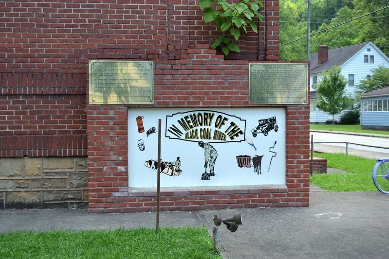
To Honor the Black Coal Miners
and Keep Their Legacy Alive
The Black Coal Miner was recruited by International Harvester and U.S. Steel to work and live in the coal camps of Benham and Lynch. They came in search of a better life, better . . . — — Map (db m97160) HM
On West Penn Street at County Road 1004, on the right when traveling west on West Penn Street.
School named for Benjamin Banneker
Principals were
W. E. Newsom
E. O. David
Consolidated with
Harrison County School System 1963 — — Map (db m218105) HM
On Caldwell Street east of East Union Street, on the right when traveling east.
A noted 19th century African American poet, Whitman was born into slavery in Hart County on May 30, 1851. Self- educated, by age 22 he had published two books of poetry, Essays on the Ten Plagues and Other Miscellaneous Poems and Leelah . . . — — Map (db m174374) HM
Carter-Dowling School Upon closing its one room schools in 1950, the Hart County Board of Education constructed Carter-Dowling School, a consolidated elementary school for "colored" children of Hart County. The School was named for Daisie C. . . . — — Map (db m39983) HM
On E South Street north of Main Street (U.S. 31W), on the left when traveling north.
(Side A)
In 1945, Hart County had 67 One-Room Schools scattered throughout the county. These 67 schools served students in grades first through eighth.
Not quite a decade later, all One-Room Schools in Hart County had been closed. At . . . — — Map (db m174340) HM
On Dixie Highway / Main Street (U.S. 31W) at South Street, on the left when traveling south on Dixie Highway / Main Street.
The small, unassuming county-seat village of Munfordville, founded on an old buffalo crossing and home to a well-known tavern, could claim pride of place in 1860 as the spot where the L&N Railroad crossed the Green River, over what whas then the . . . — — Map (db m39984) HM
Near North Water Street north of 1st Street, on the left when traveling north.
William Christopher (W.C.) Handy, the Father of the Blues, lived in Henderson from 1892 to 1903. Handy, recognized as the first person to publish the blues, received his "calling" to create this written record while in Henderson. "It was . . . — — Map (db m121600) HM
On North Water Street at 1st Street, on the left when traveling north on North Water Street.
"A very large part of the state is completely overrun with guerrillas, who plunder farm-house, and fields, and villages at will, and often murder the helpless victims of their robberies."
-Letter from Adjutant-General J. Holt to . . . — — Map (db m121698) HM
On South Elm Street at Washington Street, on the right when traveling north on South Elm Street.
The church was formed in 1840.
Blacks Were baptized and admitted
to the white Baptist church. In
1845 the African Baptist Church
organized with separate services
in the basement of the church led
by Rev. Willis Walker, an enslaved
man. The . . . — — Map (db m172029) HM
On South Main Street (U.S. 421) south of East Cross Main Street (Route 573), on the right when traveling south.
The Grand United Order of Odd Fellows
(GUOOF) was formed in 1843; virtually
all other fraternal organizations of the
era were whites-only. The GUOOF
provided vital support to its members
and the local black community
following the Civil War. . . . — — Map (db m136171) HM
Confederate General Leonidus Polk occupied the site of Columbus and began erecting extensive fortifications in September of 1861. In addition to the soldiers under his command, more than 13,000 at one point, over 10,000 African American slaves . . . — — Map (db m37287) HM
The Fourth United States Colored Heavy Artillery was initially organized as the Second Tennessee Heavy Artillery, African Descent and also briefly known as the Third Mississippi. Despite its initial designation as a Tennessee unit and second . . . — — Map (db m37295) HM
Settlement and Early Growth The French explorers Marquette and Joliet first explored the area around Columbus in 1673. The French gave Columbus the name "Iron Banks," believing the color of the banks indicated the presence of iron. In 1783, . . . — — Map (db m37014) HM
On North Mc Euen Avenue (Kentucky Route 1337) north of County Route 3057, on the right when traveling north.
J.W. Million School
Black students went to Earlington Colored School by 1891. Wooden school replaced by brick building in 1905 by St. Bernard Mining Co. on land donated by J.B. Atkinson.
Inspired by Rev. Joseph W. Million, activist and . . . — — Map (db m171876) HM
On North Kentucky Avenue at Couch Street, on the right when traveling north on North Kentucky Avenue.
Rosenwald High School
Here, Professor C. L. Timberlake established first high school in city for blacks. Rosenwald High School opened in 1932; operated until 1966. Rosenwald Foundation funded its construction. In 1936, basketball team . . . — — Map (db m88950) HM
On North Church Street at Oates Street, on the left when traveling north on North Church Street.
Founded in 1868 by Rev. Anthony Bunche, Zion Temple A.M.E. Zion Church is the oldest African-American church in Hopkins Co. It was established in an old log schoolhouse given by abolitionist Hubbard Lunsford. The current site was purchased in 1878. . . . — — Map (db m171905) HM
Near Bashford Manor Lane, 0.1 miles west of Bardstown Road (U.S. 31E), on the left when traveling west.
Alonzo "Lonnie" Clayton
Born in Kansas City, Mo. in 1876, he followed his brother into the riding profession. At age 12, he went to Chicago to become an exercise rider. With his first win in 1891, he came to Louisville to ride for Bashford . . . — — Map (db m162005) HM
On La Grange Road (State Road 146) at Heafer Road, on the right when traveling north on La Grange Road.
This eastern Jefferson County community began with five acres purchased in 1874 by Alfred Berry, a freedman. Other Berrytown founders were Wm. Butler, Sallie Carter, and Kidd Williams, all of whom bought land from Samuel L. Nock, a wealthy . . . — — Map (db m161778) HM
On Berrytown Road at Woodbrook Court, on the right when traveling east on Berrytown Road.
This cemetery became focal point for the Berrytown community, which began when Alfred Berry purchased five acres in 1874. Berrytown Cem. was purchased on June 23, 1890, by United Brothers of Friendship Lodge No. 83. As trustees, Lodge members . . . — — Map (db m161779) HM
Near Old Stage Coach Road, 0.1 miles east of Long Run Road, on the right when traveling east.
Born a slave, he was a member of the Long Run church. A bachelor, he remained in the employ of his former master during his life; when he died in 1923, Gregg was the last negro member of the congregation. — — Map (db m203143) HM
On Berrytown Road east of La Grange Road (Kentucky Road 146), on the right when traveling east.
The Forest School was originally built in 1905 as one room, located between Anchorage and Obannon Road. The school was later relocated to two lots on Berrytown Road. In 1912 an additional room was added and in 1928 another room was added giving the . . . — — Map (db m161777) HM
On Medford Lane at Bashford Manor Lane, on the right when traveling north on Medford Lane.
Bray Place
Major Samuel Bray surveyed here in 1779 & returned with his family in 1796. He built original two-story house ca. 1800. Bray served in the Ky. legislature in 1820. In 1851, former slaves Henry & Eliza Tevis bought 40 acres from . . . — — Map (db m162007) HM
Earl McDonald (1885-1949) helped establish Louisville as the home of jug band music. An accomplished jug blower, vocalist, composer, leader, & recording artist. Bands in Australia, Europe, and Japan continue to admire, perform, and emulate his 42 . . . — — Map (db m161166) HM
On Virginia Avenue at Interstate 264, on the left when traveling west on Virginia Avenue.
Located west of 32nd and south of Garland Ave., "Little Africa" was original African American section of Parkland. Settled in 1870s, African Americans first called it "Needmore." "Little Africa" evolved from a shantytown into a thriving community by . . . — — Map (db m161683) HM
On West Broadway west of South 32nd Street, on the left when traveling west.
Carl Braden Memorial Center
Carl and Anne Braden were committed to bringing together people of color and white people to work for social and racial justice. National figures such as Dick Gregory, Angela Davis, Jesse Jackson, and Pete Seeger . . . — — Map (db m161250) HM
On Grand Avenue, on the right when traveling east.
Muhammad Ali's Home Site
Cassius Marcellus Clay, Jr. was born on January 17, 1942 at Louisville General Hospital. He grew up and lived here at 3302 Grand Ave. with his parents, Odessa & Cassius Clay, Sr., and brother, Rudolph. Ali attended . . . — — Map (db m161678) HM
On Southwestern Parkway at Hale Avenue, on the right when traveling north on Southwestern Parkway.
Samuel M. Plato developed quality single-family housing for Blacks in West Louisville from 1945-1950. His firm, Plato Construction Company, built 88 homes in the Westover Neighborhood. Plato Terrace was named in his honor. Plato designed and built . . . — — Map (db m161702) HM
On Virginia Avenue west of South 36th Street, on the left when traveling west.
The Virginia Avenue Colored School opened in 1923. It was constructed via a million-dollar bond the Louisville Board of Education used to acquire sites and build new structures. Samuel Plato, one of the country’s first African American architects, . . . — — Map (db m161680) HM
On West Muhammad Ali Boulevard at Cathedral Way, on the left when traveling west on West Muhammad Ali Boulevard.
Sit-In Demonstration Site
Blue Boar Cafeteria
644 South Fourth Street
410 West Muhammad Ali Blvd.
(formerly Walnut Street)
One of two Blue Boar Cafeterias was located at this site. Blue Boar was part of a regional chain that primarily . . . — — Map (db m178312) HM
On South 4th Street at West Chestnut Street, on the right when traveling south on South 4th Street.
The full-scale assault on racial segregation in Louisville began in Feb. 1961, when local high school students staged non-violent demonstrations. Under leadership of the NAACP & CORE, they demanded passage of laws to end public racial . . . — — Map (db m178317) HM
On West Chestnut Street east of South 9th Street, on the left when traveling east.
Center Street C.M.E. Church
Center Street C.M.E. was outgrowth of M.E. Church South. Became first of denomination in Louisville during early 1870s and hosted 3rd General C.M.E. Conference in 1874. Under leadership of Dr. L. H. Brown, church . . . — — Map (db m161256) HM
On South 6th Street at West Jefferson Street (U.S. 60), on the right when traveling south on South 6th Street.
First African American elected to southern state legislature in 20th century; six consecutive terms in Gen. Assembly, beginning in 1935. A Republican from Louisville, he sponsored repeal of Ky.'s public hanging law; funds for African Americans to . . . — — Map (db m161228) HM
On South 4th Street south of West Muhammad Ali Boulevard, on the right when traveling south.
In Spring 1960, sit-in demonstrations spread throughout the South, as young African Americans demanded an end to second-class treatment in restaurants, department stores, and movie theaters. In Louisville, the sit-in campaign for an ordinance . . . — — Map (db m178315) HM
On W. Main Street (U.S. 31W) at N. 4th Street, on the right when traveling west on W. Main Street.
Thornton and Lucie (also called Ruthy) Blackburn were slaves in Louisville, 1830-31. Thornton was hired out to Wurts and Reinhard's store at 4th and Main. When Lucie was sold to Virgil McKnight, the two escaped by steamboat. They were claimed two . . . — — Map (db m178310) HM
On West River Road, 0.1 miles north of North 4th Street.
Lewis and Clark in Kentucky
York
This enslaved African American who lived most of his life in Louisville, went on Lewis and Clark Expedition to the Pacific, 1803-6. York was the first African American to cross the U.S. coast to coast and . . . — — Map (db m70385) HM
On South 8th Street south of West Muhammad Ali Boulevard, on the left when traveling south.
Nannie Helen Burroughs A suffragist, orator, educator, & club/church leader for gender and racial equality, she worked in Louisville for the Foreign Mission Board of Nat’l Baptist Convention from 1900-1910. She created the Woman’s Industrial . . . — — Map (db m203253) HM
On South 8th Street at West Liberty Street (U.S. 60), on the right when traveling south on South 8th Street.
Site of Kentucky's only Catholic high school for blacks. It existed at this location from 1928-1958, operated by the Archdiocese of Louisville. Founded in 1921, the school was administered by pastors of St. Augustine and St. Peter Claver churches, . . . — — Map (db m162237) HM
Second African Baptist Church, now Green Street Baptist Church, was formally organized here, Sept. 29, 1844. As was usual in the years of slavery, the founding members had the sponsorship of a protection committee, appointed by First Baptist . . . — — Map (db m103608) HM
On South 4th Street, on the left when traveling south.
Kaufman-Straus Department Store was located at this site. Kaufman's was one of two large department stores targeted for demonstrations due to its discrimination policy. In early 1960 student members of CORE (Congress of Racial Equality), headed . . . — — Map (db m178313) HM
On South 4th Street at West Muhammad Ali Boulevard, on the right when traveling north on South 4th Street.
Stewart's Dry Goods, the largest and most prestigious department store in Louisville, was located at this site. In the 1950s, a trip to Stewart's was a special occasion, requiring a hat and gloves for ladies doing a day of shopping or eating lunch . . . — — Map (db m178314) HM
On South 4th Street at Guthrie Street, on the left when traveling north on South 4th Street.
Walgreens drugstore was located at this site prior to its move in early 2000. On November 27, 1958, a delegation of representatives accompanying Mrs. Iris King, Mayor of Kingston, Jamaica, stopped here briefly to have a cup of coffee following a . . . — — Map (db m178320) HM
On South 4th Street just south of West Chestnut Street, on the right when traveling south.
The Rialto and Mary Anderson Theaters were the sites of mass demonstrations and arrests during the Nothing New for Easter campaign.
The Rialto Theater opened in 1921 as Louisville's first grand movie palace. The first of the theaters . . . — — Map (db m178902) HM
On South 4th Street just south of West Chestnut Street, on the left when traveling south.
The Louisville Palace Theater originally opened as the Loew's Theater in 1928, and is the former site of the Penthouse/United Artists Theater. The historic landmark opened in 1928 and was designed by architect John Eberson.
Elegant and . . . — — Map (db m178894) HM
On South 4th Street at West Jefferson Street, on the right when traveling north on South 4th Street.
The Sit-In Demonstration Sites Markers Project preserves an important part of Louisville’s history. Designed by nationally recognized sculptor Ed Hamilton, each marker bears a logo depicting student protesters to symbolize the civil rights . . . — — Map (db m178321) HM
On S 2nd Street at W Main Street, on the right when traveling north on S 2nd Street.
Slave Trading In Louisville. By the 1850s, Kentucky was annually exporting between 2500 and 4000 of its slaves down river to the large plantations further south. To prevent runaways, traders operating near the Ohio River kept slaves shackled . . . — — Map (db m104173) HM
Slavery Laws In Old Kentucky. Ky.'s 1792 Constitution continued legalized enslavement of blacks in the new state; 1800 tax lists show 40,000 slaves. U.S. banned African slave trade in 1808 but selling of men, women and children in South . . . — — Map (db m103609) HM
On W Main Street, 0.2 miles north of Place Montpellier, on the right when traveling west.
York
(ca. 1772 - before 1832)
Member of the Lewis and Clark Expedition (1803-1806) to the Pacific Ocean
York was the first African American to cross the United States from coast to coast. Born a slave belonging to the Clark family, York was . . . — — Map (db m104251) HM
Throughout the nineteenth century, Kentucky led the nation in hemp production. By the 1830s, Farmington was 550-acre working hemp plantation - a center of agriculture and industry. Hemp, the most labor-intensive crop grown in the state, perpetuated . . . — — Map (db m244654) HM
On Bardstown Road (U.S. 31E) at Wendell Avenue, on the right when traveling north on Bardstown Road.
Historic residence completed 1816 for John and Lucy (Fry) Speed. The Jefferson-inspired plan by Paul Skidmore includes octagonal rooms, rare in 19th c. Kentucky. As many as 64 African Americans enslaved at Farmington worked the 550-acre hemp . . . — — Map (db m162002) HM
To 1997, archaeologists from the Kentucky Archeological Survey and the University of Louisville excavated a 16x16 stone foundation documented to the Rutherford watercolor as a one-story wooden cabin. Based on artifacts recovered from the site, . . . — — Map (db m244656) HM
On Lexington Road, on the right when traveling west.
Born in 1899 in Indianapolis, Walls earned an M.A. from NY's Columbia Univ. As a teacher, she developed an early black history program in Indiana. In 1930s, Walls worked to secure public housing for blacks in Louisville. In 1940s, she led . . . — — Map (db m161750) HM
On West Kentucky Street west of South 7th Street (Kentucky Route 1931), on the right when traveling east.
Located on original site of Simmons University and Bible Collège, a black institution. Opened Feb. 9, 1931, as the segregated branch of University of Louisville in response to black political activism. It was third municipally supported college for . . . — — Map (db m203388) HM
On West Kentucky Street at South 6th Street, on the right when traveling east on West Kentucky Street.
Designed in 1873 by B.J. McElfatrick, architect, as first black public school in Ky. Central Colored School served as cultural and educational center for city's black community until 1894. Then, because of overcrowding, Central relocated. Education . . . — — Map (db m161289) HM
On South 6th Street, on the right when traveling south. Reported missing.
Built in 1888 for German immigrant and hotelier Louis Seelbach (1852-1925) and designed by architects Wehle and Dodd in a modified Richardsonian Romanesque form. This house set the tone for other houses built on this block. In 1905, Seelbach & his . . . — — Map (db m161287) HM
On South 7th Street north of Zane Street, on the left when traveling north.
School proposed by Gen. Assoc. of Colored Baptists in Kentucky and chartered through legislature in 1873 as Ky. Normal and Theological Institute. Frankfort was the first site suggested but Assoc. selected Louisville. Charter amended in 1882, . . . — — Map (db m161288) HM
On Petersburg Road, 0.2 miles south of Unseld Boulevard, on the right when traveling south.
Forest Home Cemetery evolved from an old slave burial ground and is final resting place of Eliza Curtis Hundley Tevis (ca. 1802-84) and other early settlers of Petersburg community. Tevis was born a slave but gained freedom in 1833. She and her . . . — — Map (db m162013) HM
On South 4th Street south of York Street, on the right when traveling south.
In 1941, the Louisville Service Club opened in the former Knights of Columbus and Columbia Auditorium building. The club provided weekend housing and entertainment for service men in the city in the lead up to US entry into World War II. The . . . — — Map (db m161371) HM
On York Street at Library Place, on the left when traveling east on York Street.
Born in 1899, Walls fought to end segregation in public housing, city libraries, and local Girl Scouts. Walls led the movement that integrated Girl Scout programs and camps by 1956. She was the first black woman to serve on the Girl Scout Board and . . . — — Map (db m104727) HM
On West Broadway at South 4th Street, on the left when traveling east on West Broadway.
Built in 1923 by Louisville businessman James Graham Brown, the Brown Hotel has anchored the 'Magic Corner' of Fourth and Broadway for decades. Over the years the hotel has hosted an array of dignitaries, actors, and presidents, as well as . . . — — Map (db m178897) HM
On West Broadway (U.S. 150) just west of South 3rd Street (Kentucky Route 1020), on the right when traveling west.
Constructed in 1925 as a live performance venue, the Brown Theatre was soon converted into a movie theatre in 1930 to respond to the changing economic realities of the Great Depression. Through the 1950s, the Brown served as a first-run movie . . . — — Map (db m178901) HM
On South 4th Street, 0.1 miles south of York Street, on the right when traveling south.
Remembering the life and legacy of the lake Derek Smith, Spalding University has named the campus gymnasium in honor of this wonderful man. Derek, a member of UDFL's 1980 NCAA Championship Team and a nine-year NBA star, held his first high school . . . — — Map (db m179906) HM
On South 28th Street at Woodland Avenue, on the right when traveling south on South 28th Street.
Black members of Walnut Street Baptist Church formed own congregation by 1829, and began worshipping on Market St. They acquired lot on Fifth & York, 1833; held services there until 1957. The church played an especially prominent role under the . . . — — Map (db m161677) HM
On East Gray Street west of South Hancock Street, on the right when traveling west.
This church was constituted on Green Street, Sept. 29, 1844, with Brother George Wells as pastor. A noted trustee and treasurer was Ben Duke, who lived to age 110. Present church built 1930 by Samuel Plato under pastorate of H. W. Jones. Scene of . . . — — Map (db m161270) HM
On Poplar Level Road (State Road 864) 0.1 miles south of Eastern Parkway, on the right when traveling north.
Louisville Cemetery
Original 31 acres incorporated Mar. 23, 1886, by prominent black citizens Bishop W. H. Miles, H. C. Weeden, J. Meriwether, A. J. Bibb, W. P. Churchill, William H. Gibson, Sr., and Felix Johnson. Buried here are Dr. Robert . . . — — Map (db m161299) HM
On North 37th Street at Pflanz Avenue, on the right when traveling north on North 37th Street.
In 1914, the Louisville Board of Aldermen passed an ordinance prohibiting a person of one race from living on a block where the majority of residents were of another race. In response, Nat'l Assoc. for the Advancement of Colored People (NAACP) . . . — — Map (db m161704) HM
On West Chestnut Street east of South 10th Street, on the right when traveling east.
Dr. James Bond (1863-1929)
Born in Woodford County during slavery, James Bond was raised in Knox Co. He led a young steer to Berea College for his tuition. In 1896, became a trustee of Berea. After Day Law passed, he joined college's staff . . . — — Map (db m161254) HM
On West Muhammad Ali Boulevard west of South 23rd Street, on the right when traveling west.
I. Willis Cole, 1887-1950
Militant editor and sole owner of The Louisville Leader and I. Willis Cole Publishing Co. (1917-1950). A race paper boasting, “We print your news, we employ your people, we champion your cause,” . . . — — Map (db m161249) HM
On West Chestnut Street east of South 10th Street, on the right when traveling east.
Knights of Pythias Temple
The Knights of Pythias Lodge was organized in 1893 and the state headquarters built, 1915, at a cost of $130,000. The same prominent leaders organized the Lodge and Chestnut Street YMCA. Among those founding fathers . . . — — Map (db m161255) HM
On West Chestnut Street at South 10th Street, on the right when traveling east on West Chestnut Street.
This Carnegie-endowed library was one of the first in the nation to extend privileges to the black community. The library was first in William M. Andrews' residence at 1125 West Chestnut, now gone. The present library was designed by the . . . — — Map (db m161253) HM
On West Broadway (U.S. 60) at 13th Street, on the right when traveling west on West Broadway.
Samuel M. Plato, Architect. Samuel Plato was a prominent African American architect. He was born in 1882 in Montgomery County, AL. Attended schools in Waugh, AL, Winston-Salem, NC, & 1902 State Univ. Normal school, now Simmons College. Early . . . — — Map (db m161251) HM
On West Muhammad Ali Boulevard at South 22nd Street, on the left when traveling west on West Muhammad Ali Boulevard.
Congregation was organized by 18
Blacks in Aug., 1878. First church
on Center St., 1882; present church
bought, 1927. Notable pastors have
been W. H. Craighead, D.E. King,
A.D. Wms. King (brother of Dr.
Martin Luther King, Jr.) and . . . — — Map (db m203236) HM
On South Shelby Street at Lydia Street, on the right when traveling south on South Shelby Street.
In 1899, because black physicians were barred from treating patients at public or church hospitals, Drs. W. T. Merchant, Ellis D. Whedbee and R. B. Scott founded Red Cross Hospital at Sixth & Walnut Street. In 1905, it moved to 1436 S. Shelby St. . . . — — Map (db m161298) HM
On South Hancock Street south of Roselane Court, on the right when traveling south.
The Presbyterian Community Center was founded in 1898 on Preston Street by Rev. John Little. It was Louisville’s first African American Mission Sunday school. A second location on Hancock Street opened in 1902. The Centers were known as Hope and . . . — — Map (db m161264) HM
On South Hancock Street at East Jacob Street, on the right when traveling north on South Hancock Street.
Born in Waynesboro, Virginia, in 1865, Sheppard attended Hampton and Stillman Institutes. Sent to the Belgian Congo in 1890, he served as missionary in Africa until 1910. Became a fellow of the Royal Geographic Society of London in 1893 for his . . . — — Map (db m161266) HM
On East Broadway at South Hancock Street, on the right when traveling east on East Broadway.
Smoketown
This historically black community began to flourish following end of slavery in 1865, when thousands of African Americans moved to Louisville. Shotgun-type houses on closely spaced streets and alleys allowed both black and white . . . — — Map (db m161263) HM
On South Brook Street, on the right when traveling south.
Alpha Kappa Alpha Sorority, Inc. was founded on January 15, 1908 on the campus of Howard University. Led by visionary leader, Ethel Hedgeman Lyle, 16 students founded the sorority on five basic tenets: to cultivate and encourage high scholastic and . . . — — Map (db m203470) HM
On South Brook Street, on the right when traveling south.
Alpha Phi Alpha Fraternity,
Incorporated was founded on an ice-
cold Tuesday December 4th, 1906. It
was founded on the campus of
Cornell University in Ithaca, New
York by the seven "Jewels” (Henry
Arthur Callis, Charles Henry
Chapman, Eugene . . . — — Map (db m203469) HM
Journalist and nationally known civil rights activist, Anne Braden was a key leader in the struggle for racial justice from the 1950s until her death. Although she and her husband, Carl, were once considered the most hated couple in Louisville, she . . . — — Map (db m114970) HM
Renowned educator, writer, and social scientist,
Charles Henry Parrish, Jr. was born on January 12,
1899, in Louisville, KY. A graduate of historic
Central High School in 1916, Parrish went on to
attend Howard University receiving his A.B. . . . — — Map (db m203466) HM
In 1950-51 University of Louisville campus was integrated. One African American professor came from Louisville Municipal College, where only blacks had previously been enrolled. Charles H. Parrish, Jr., a noted sociologist and a lifelong civil . . . — — Map (db m203464) HM
On South Brook Street, on the right when traveling south.
Delta Sigma Theta Sorority, Incorporated was founded on January 13, 1913 by 22 collegiate women at Howard University to promote academic excellence and provide assistance to those in need. The first public act performed by the Founders of Delta . . . — — Map (db m203474) HM
On W. Cardinal Boulevard, 0 miles S. 2nd Street, in the median.
Scholar and educator, Dr. Parrish joined the faculty of Simmons University in 1921 and moved to Louisville Municipal College, the black branch of the University of Louisville, in 1931. In 1951, when the University of Louisville desegregated and . . . — — Map (db m114910) HM
On W. Cardinal Boulevard just west of S. 2nd Street, on the left when traveling west.
Scholar and educator, Dr. Love became the first black librarian at the University of Kentucky in 1955 and, a decade later, became the first director of Project Upward Bound and an assistant dean at the University of Louisville. A faculty member in . . . — — Map (db m114913) HM
On S. 3rd Street, 0 miles south of W. Cardinal, on the left when traveling north.
Author and historian, Dr. Hudson served as Chair of the Department of Pan-African Studies and in 2005 became permanent Dean of the College of Arts and Sciences. Dr. Hudson was a scholar in global African ancestry, inter-cultural education, . . . — — Map (db m114934) HM
Scholar, educator and activist, Dr. McMillan graduated from the University of Louisville in 1950. After a successful career as a public school educator in Michigan, Dr. McMillan returned to the University in 1976 as an assistant provost, professor . . . — — Map (db m115018) HM
Scholar and educator, Dr. Clement served as the first dean of Louisville Municipal College, the segregated branch of the University of Louisville, from 1931 to 1937. Under his leadership, Municipal attracted an extremely strong faculty and soon . . . — — Map (db m115014) HM
On South 3rd Street south of West Cardinal Boulevard, on the left when traveling south.
The United States faced two fundamental tasks during the Reconstruction period (1865-1877). One was the need to redefine and renormalize relations between the former Confederate states and the rest of the nation. The other was to redefine the role . . . — — Map (db m245713) HM
On South 3rd Street (Kentucky Route 1020) south of West Cardinal Boulevard, on the left when traveling south.
The American Civil War brought two opposing views of freedom into direct and violent conflict—and nowhere more so than in Kentucky. Kentucky was deeply divided over the issues of slavery and secession. Confederate sentiments were as strong in some . . . — — Map (db m245716) HM
On South 3rd Street south of West Cardinal Boulevard, on the left when traveling south.
Enslaved African Americans could not free themselves under American law. An African American might be set free by his or her owner, or might be emancipated by governmental action, neither of which was likely—or, an enslaved African American might . . . — — Map (db m245717) HM
On South Brook Street, on the right when traveling south.
Iota Phi Theta Fraternity, Incorporated was founded on September 19, 1963 on the campus of Morgan State University (then Morgan State College) by Albert Hicks, Lonnie Spruill, Jr., Charles Briscoe, Frank Coakley, John Slade, Barron Willis, Webster . . . — — Map (db m203480) HM
On South Brook Street, on the right when traveling south.
Kappa Alpha Psi Fraternity,
Incorporated was chartered and
incorporated on the campus of
Indiana University on January 5, 1911
with the sole purpose of achievement
in every field of human endeavor. This
was accomplished by the . . . — — Map (db m203472) HM
On South Brook Street, on the right when traveling south.
The National Pan-Hellenic Council (NPHC) was founded on May 10th, 1930 at Howard University. The founding members of the NPHC were Kappa Alpha Psi, Omega Psi Phi, Alpha Kappa Alpha, Delta Sigma Theta, and Zeta Phi Beta. The council's membership . . . — — Map (db m203468) HM
On South Brook Street, on the right when traveling south.
Omega Psi Phi Fraternity, Incorporated was founded on November 17th, 1911 on the campus of Howard University by Edgar Amos Love, Oscar J. Cooper, Frank Coleman and their Faculty Advisor, Dr. Ernest Everett Just. The Fraternity motto is “Friendship . . . — — Map (db m203473) HM
On South Brook Street, on the right when traveling south.
Phi Beta Sigma Fraternity, Incorporated was founded on Friday January 9th in 1914. It was founded on the beloved campus of Howard University in Washington, D.C. by the Honorable Founders Abram Langston Taylor, Leonard Francis Morse, and Charles . . . — — Map (db m203475) HM
On South Brook Street, on the right when traveling south.
Sigma Gamma Rho Sorority, Incorporated was founded on November 12th, 1922, on the campus of Butler University by seven young educators: Mary Lou Allison Gardner Little, Dorothy Hanley Whiteside, Vivian White Marbury, Nannie Mae Gahn Johnson, Hattie . . . — — Map (db m203478) HM
On West Cardinal Boulevard just west of S. 2nd Street.
Former mayor of Louisville and lieutenant governor of Kentucky, Wyatt also served as a member of the University of Louisville Board of Trustees and made the first motion to desegregate the University in 1949 — — Map (db m114911) HM
On W. Cardinal Boulevard at S. 2nd Street on W. Cardinal Boulevard.
Businessman and civil rights leader, Mr. Porter served twenty-four years on the board of trustees at the University of Louisville, four terms as chairman and helped guide the University into the state system of higher education. A firm believer that . . . — — Map (db m114950) HM
On South Brook Street, on the right when traveling south.
Zeta Phi Beta Sorority, Incorporated was founded on January 16th, 1920 on the campus of Howard University in Washington, D.C. by the organization's five Pearls (Arizona Cleaver Stemons, Pearl Anna Neal, Viola Tyler Goings, Myrtle Tyler Faithful & . . . — — Map (db m203477) HM
On Old Harrods Creek Road, 0.1 miles north of Willow Stone Way, on the right when traveling north.
The Louisville and Frankfort Shortline railroad, which arrived in eastern Jefferson County through Hobbs Station (now Anchorage) in 1848, created a cluster of communities which would be known as Anchorage, Berrytown, and Griffytown.
Local . . . — — Map (db m161783) HM
On River Road at Shirley Avenue, on the right when traveling west on River Road.
James Taylor (1885-1965) was chiefly responsible for the modern Harrods Creek community. Ambitious entrepreneur, Taylor purchased land from Mary Shirley Helm in 1919 and began to sell lots to other African Americans in 1923. The Taylor Subdivision . . . — — Map (db m161773) HM
302 entries matched your criteria. Entries 101 through 200 are listed above. ⊲ Previous 100 — Next 100 ⊳