After filtering for Missouri, 292 entries match your criteria. The first 100 are listed. ⊳
Education Topic
By Michael E Sanchez, Jr., March 24, 2017
Early Days of Adair County, Missouri Marker back
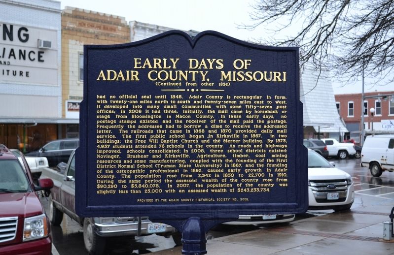
| 1 ► Missouri, Adair County, Kirksville — Early Days of Adair County, Missouri — |
| On North Franklin Street just north of West Washington Street, on the left when traveling north. | |||
| 2 ► Missouri, Adair County, Kirksville — The Cyclone — April 27, 1899 — |
| On North Elson Street just north of West Washington Street, on the left when traveling south. | |||
| 3 ► Missouri, Audrain County, Mexico — Hardin College Bell — June 1873 - May 1932 — |
| Near Missouri Route 15. | |||
| 4 ► Missouri, Audrain County, Mexico — Mexico — |
| On Mudrow Street (Missouri Route 15) at Hisey Street, on the right when traveling south on Mudrow Street. | |||
| 5 ► Missouri, Audrain County, Mexico — Missouri Military Academy — |
| 6 ► Missouri, Audrain County, Mexico — The Churchill Gate — |
| On Clark Street (U.S. 54) at Hendy Street, on the right when traveling north on Clark Street. | |||
| 7 ► Missouri, Barry County, Hilltop — Roaring River School — |
| On "No Name", 0.2 miles south of State Highway 112, on the left when traveling south. | |||
| 8 ► Missouri, Barton County, Lamar — Replica of the Statue of Liberty — |
| On Broadway at 11th Street, on the left when traveling north on Broadway. | |||
| 9 ► Missouri, Bates County, Butler — North Field — Webster School 1900 — |
| On Mill Street (State Road H) at Havannah Street, on the right when traveling east on Mill Street. | |||
| 10 ► Missouri, Bates County, Rich Hill — 33 — Harmony Mission — American Presbyterian and Reformed Historical Site No. 33 — |
| On Walnut Street (State Highway A) at 13th Street, on the right when traveling east on Walnut Street. | |||
| 11 ► Missouri, Boone County, Columbia — "Make A Brighter Future" — |
| On East Stewart Road just west of South Providence Road (State Highway 163), in the median. | |||
| 12 ► Missouri, Boone County, Columbia — African-American Heritage Trail — |
| On South 5th Street at Davis Street, on the right when traveling north on South 5th Street. | |||
| 13 ► Missouri, Boone County, Columbia — African-American Heritage Trail — |
| On North 5th Street just north of East Ash Street, on the left when traveling north. | |||
| 14 ► Missouri, Boone County, Columbia — African-American Heritage Trail — |
| On East Broadway, 0.1 miles west of North 1st Street, on the left when traveling west. | |||
| 15 ► Missouri, Boone County, Columbia — African-American Heritage Trail — |
| On North Providence Road (State Highway 163) at East Ash Street, on the left when traveling north on North Providence Road. | |||
| 16 ► Missouri, Boone County, Columbia — African-American Heritage Trail — |
| On Switzler Street just west of Lasalle Place, on the right when traveling west. | |||
| 17 ► Missouri, Boone County, Columbia — Beetle Bailey — |
| Near Conley Avenue. | |||
| 18 ► Missouri, Boone County, Columbia — Columbia — |
| On Old U.S. 63 just south of Shepard Boulevard, on the right when traveling south. | |||
| 19 ► Missouri, Boone County, Columbia — Don Faurot / Faurot Field — |
| On Stadium Boulevard (Missouri Route 740) at Providence Road (Missouri Route 163), on the right when traveling east on Stadium Boulevard. | |||
| 20 ► Missouri, Boone County, Columbia — George Clinton Swallow — A.M., M.D., L.L.D. — 1817 - 1899 — |
| 21 ► Missouri, Boone County, Columbia — In Loving Memory of Mrs. Beulah Ralph — |
| On North Providence Road (State Highway 163) at Boone Drive, on the right when traveling north on North Providence Road. | |||
| 22 ► Missouri, Boone County, Columbia — James Shannon L.L.D. — |
| 23 ► Missouri, Boone County, Columbia — Jewell Cemetery — |
| Near Providence Road (Missouri Route 163) south of Green Meadows Road, on the right when traveling south. | |||
| 24 ► Missouri, Boone County, Columbia — Lest We Forget: Lynching at the Stewart Road Bridge — |
| Near South Providence Road (State Highway 163) 0.1 miles south of East Stewart Road, on the left when traveling north. | |||
| 25 ► Missouri, Boone County, Columbia — Memorial Union Tower — |
| On Hill Street, 0.1 miles south of University Avenue, on the left when traveling south. | |||
| 26 ► Missouri, Boone County, Columbia — Missouri-Kansas-Texas Railroad Yard — Downtown Columbia, MO — |
| On South 4th Street at Cherry Street, on the right when traveling south on South 4th Street. | |||
| 27 ► Missouri, Boone County, Columbia — Site of Columbia College — |
| On 6th Street south of Chestnut Street, on the right when traveling south. | |||
| 28 ► Missouri, Boone County, Columbia — The John William "Blind" Boone Home and the Second Missionary Baptist Church — |
| On North 4th Street just north of East Broadway, on the right when traveling north. | |||
| 29 ► Missouri, Boone County, Columbia — The Mel Carnahan Quadrangle — Honoring Leadership in Public Service — |
| On Conley Avenue at Missouri Avenue on Conley Avenue. | |||
| 30 ► Missouri, Buchanan County, St. Joseph — St. Joseph Museum — |
| On Charles Street at South 11th Street, on the right when traveling east on Charles Street. | |||
| 31 ► Missouri, Buchanan County, St. Joseph — The One-Room Schoolhouse — |
| On South 9th Street (Business Interstate 29) north of Mitchell Avenue, on the left when traveling south. | |||
| 32 ► Missouri, Callaway County, Fulton — Alpha Delta of Beta Theta Pi — Historic Greek Chapter — |
| On Westminster Avenue south of West 6th Street, on the right when traveling north. | |||
| 33 ► Missouri, Callaway County, Fulton — President Robert L. D. Davidson — 1909 - 1998 — |
| On Westminster Avenue at 6th Street, on the left when traveling north on Westminster Avenue. | |||
| 34 ► Missouri, Callaway County, Fulton — Robertson Historic District — Historic Fulton Missouri — |
| On 7th Street east of Westminster Avenue, on the left when traveling west. | |||
| 35 ► Missouri, Callaway County, Fulton — War Comes to Westminster College — Missouri's Civil War — |
| On Westminster Avenue at 5th Street, on the left when traveling north on Westminster Avenue. | |||
| 36 ► Missouri, Callaway County, Fulton — Westminster College Columns — |
| On C. F. Lampkin Drive, on the left when traveling south. | |||
| 37 ► Missouri, Callaway County, Fulton — Westminster Hall Threshold — 1911 - 1974 — |
| On C. F. Lampkin Drive, on the right when traveling south. | |||
| 38 ► Missouri, Callaway County, Fulton — William Chrisman Swope Memorial Chapel — Erected A.D. 1917-1918 — |
| On C. F. Lampkin Drive, on the left when traveling south. | |||
| 39 ► Missouri, Cape Girardeau County, Cape Girardeau — 1870 — St. Vincent's Young Ladies Academy — |
| On North Water Street south of Broadway Street, on the left when traveling south. | |||
| 40 ► Missouri, Cape Girardeau County, Cape Girardeau — George Washington Carver — |
| On Water Street. | |||
| 41 ► Missouri, Cape Girardeau County, Cape Girardeau — St Vincent's Seminary and Southeast Missouri State University — |
| On Aquasmi Street. | |||
| 42 ► Missouri, Cedar County, El Dorado Springs — Former School Districts in El Dorado Springs R-2 — |
| On Grand Avenue at Pine Street, on the left when traveling south on Grand Avenue. | |||
| 43 ► Missouri, Clay County, Liberty — Clay County African American Pioneers — |
| On Franklin Street at Water Street, on the left when traveling west on Franklin Street. | |||
| 44 ► Missouri, Clay County, Liberty — Frank Hughes Memorial Library — |
| On Franklin Street at Leonard Street, on the left when traveling east on Franklin Street. | |||
| 45 ► Missouri, Clay County, Liberty — Intelligencia — |
| On Water Street north of Mill Street, on the left when traveling north. | |||
| 46 ► Missouri, Clay County, Liberty — John Priest Greene President's Home — Clay County Historic Landmark — |
| Near Miller Avenue, 0 miles east of North Jewell Street. | |||
| 47 ► Missouri, Clay County, Liberty — Lucy A. Ward Love — Born Mass., 1813 — Died Mo., 1891 — |
| On Shrader Street east of Gallatin Street, on the left when traveling east. | |||
| 48 ► Missouri, Cole County, Jefferson City — Carnegie Library — |
| On Adams Street north of High Street, on the left when traveling north. | |||
| 49 ► Missouri, Cole County, Jefferson City — During the next four decades — ★ Sacrifice ★ Education ★ Equality ★ Humanity ★ Courage ★ — |
| On Chestnut Street, 0.1 miles north of Dawson Drive, on the left when traveling north. | |||
| 50 ► Missouri, Cole County, Jefferson City — Lincoln University was founded — ★ Sacrifice ★ Education ★ Equality ★ Humanity ★ Courage ★ — |
| On Chestnut Street, 0.3 miles north of East Atchison, on the left when traveling north. | |||
| 51 ► Missouri, Cole County, Jefferson City — Soldiers' Memorial Plaza — |
| On Chestnut Street north of Atchison Street, on the left when traveling north. | |||
| 52 ► Missouri, Cole County, Jefferson City — The founding of Lincoln University — Lincoln University, Jefferson City, Missouri — ★ Sacrifice ★ Education ★ Equality ★ Humanity ★ Courage ★ — |
| On Chestnut Street just north of Dawson Drive, on the left when traveling north. | |||
| 53 ► Missouri, Cole County, Jefferson City — Towards the end of the war — ★ Sacrifice ★ Education ★ Equality ★ Humanity ★ Courage ★ — |
| On Chestnut Street, 0.1 miles Dawson Drive, on the left when traveling north. | |||
| 54 ► Missouri, Cole County, Jefferson City — With the deeding of the property to the state in 1879 — ★ Sacrifice ★ Education ★ Equality ★ Humanity ★ Courage ★ — |
| On Chestnut Street, 0.1 miles north of Dawson Drive, on the left when traveling north. | |||
| 55 ► Missouri, Cooper County, Boonville — Frederick T. Kemper — 1816 - 1881 — |
| On Morgan Street near Main Street (U.S. 40), on the left when traveling east. | |||
| 56 ► Missouri, Cooper County, Boonville — George Caleb Bingham — (1811 - 1879) — |
| On Morgan Street near Main Street (U.S. 40), on the left when traveling east. | |||
| 57 ► Missouri, Cooper County, Boonville — James Milton Turner — (1839 - 1915) — |
| On Morgan Street near Main Street (U.S. 40), on the left when traveling east. | |||
| 58 ► Missouri, Cooper County, Boonville — Walter Williams — |
| On Morgan Street near Main Street (U.S. 40), on the left when traveling east. | |||
| 59 ► Missouri, DeKalb County, Maysville — DeKalb County — |
| On Main Street (Missouri Route 6) at Polk Street (Missouri Highway A), on the right when traveling west on Main Street. | |||
| 60 ► Missouri, Franklin County, Gray Summit — Missouri Botanical Garden Arboretum and Nature Reserve — |
| On Pinetum Loop Road south of Historic Route 66 (State Highway 100), on the right when traveling south. | |||
| 61 ► Missouri, Franklin County, New Haven — Thurmon Park — |
| On Wall Street just east of Maupin Avenue, on the left when traveling east. | |||
| 62 ► Missouri, Franklin County, St. Clair — This Rest Area is maintained through an Extended Employment Sheltered Workshop — MoDOT — |
| Near Interstate 44, 14 miles west of Gravois Road (Missouri Route 30), in the median. | |||
| 63 ► Missouri, Franklin County, Washington — 1891 St. Francis Borgia School Building — |
| On Cedar Street at West 2nd Street, on the right when traveling south on Cedar Street. | |||
| 64 ► Missouri, Franklin County, Washington — 1935 St. Francis Borgia School Building — |
| On Cedar Street at West 2nd Street, on the right when traveling south on Cedar Street. | |||
| 65 ► Missouri, Franklin County, Washington — Church, Rectory, and Jesuit Hall — |
| On Cedar Street at West 2nd Street on Cedar Street. | |||
| 66 ► Missouri, Franklin County, Washington — 32 — Marie Krog House — 1896 — |
| On East 2nd Street east of Jefferson Street, on the right when traveling west. | |||
| 67 ► Missouri, Franklin County, Washington — 34 — Southern Presbyterian Church — 1868 — |
| On East 2nd Street west of Market Street, on the right when traveling west. | |||
| 68 ► Missouri, Franklin County, Washington — 36 — St. Francis Borgia Convent & School — 1890 — |
| On West 2nd Street just east of Cedar Street, on the left when traveling west. | |||
| 69 ► Missouri, Franklin County, Washington — The "Welcome to Washington" Mural — |
| On Elm Street north of West Main Street, on the left when traveling north. | |||
| 70 ► Missouri, Franklin County, Washington — 6 — Zachariah Foss House — 1846 — |
| On West Front Street at Lafayette Street, on the right when traveling east on West Front Street. | |||
| 71 ► Missouri, Gasconade County, Owensville — Four Leaf Clover — |
| On 1st Street north of Peters Avenue, on the left when traveling north. | |||
| 72 ► Missouri, Gasconade County, Owensville — Mural — [cir. 1900 Owensville Parade] — |
| On North 1st Street just north of East Peters Avenue, on the right when traveling north. | |||
| 73 ► Missouri, Greene County, Springfield — Dr. Mary Jo Wynn — |
| Near East Stan Musial Drive south of U.S. 60. | |||
| 74 ► Missouri, Greene County, Springfield — Kentwood Hall Renovation — |
| On East Saint Louis Street east of South Kimbrough Avenue, on the right when traveling east. | |||
| 75 ► Missouri, Greene County, Springfield, Midtown — Civil War Entrenchments — |
| On Drury Lane, on the left when traveling north. | |||
| 76 ► Missouri, Greene County, Springfield, Midtown — Fairbanks Hall — Drury University — |
| On N. Benton Ave., 0.1 miles north of E. Central, on the right when traveling north. | |||
| 77 ► Missouri, Greene County, Springfield, Midtown — Fairbanks Hall — |
| On Benton Avenue, on the right when traveling north. | |||
| 78 ► Missouri, Greene County, Springfield, Midtown — Historic Washington Avenue Baptist Church — |
| On Bob Barker Boulevard at Drury Lane, on the right when traveling west on Bob Barker Boulevard. | |||
| 79 ► Missouri, Greene County, Springfield, Midtown — Stone Chapel — |
| Near N. Benton Ave. at E. Central, on the right when traveling north. | |||
| 80 ► Missouri, Greene County, Springfield, Midtown — Tau Eta Gamma (local) — |
| 81 ► Missouri, Greene County, Springfield, University Heights — Mary Whitney Phelps — 1812-1878 — |
| On East Brookside Drive at South Virginia Avenue, on the left when traveling east on East Brookside Drive. | |||
| 82 ► Missouri, Greene County, Springfield, Westside Community Betterment — 6 — First School-House in Greene County — |
| On Mount Vernon Street near Wabash Avenue, on the left when traveling west. | |||
| 83 ► Missouri, Grundy County, Trenton — Grundy County Jewett Norris Library — National Register of Historic Places — |
| Near Main Street at West Crowder Road, on the right when traveling south. | |||
| 84 ► Missouri, Grundy County, Trenton — Trenton — |
| On Main Street (State Highway 6) just north of East 7th Street, on the right when traveling north. | |||
| 85 ► Missouri, Hickory County, Weaubleau — John Whitaker — Aug. 15, 1842 • Jan. 6, 1910 — |
| On Main Street north of U.S. 54, on the right when traveling north. | |||
| 86 ► Missouri, Hickory County, Weaubleau — Weaubleau Christian Institute and College — |
| On Main Street, 0.1 miles north of U.S. 54, on the right when traveling north. | |||
| 87 ► Missouri, Howard County, Glasgow, Chariton Township — Lewis Library — |
| On Market Street just west of 4th Street, on the right when traveling west. | |||
| 88 ► Missouri, Howard County, Glasgow, Chariton Township — Saint Mary's Catholic Church — |
| On Howard Street at 3rd Street, on the right when traveling east on Howard Street. | |||
| 89 ► Missouri, Iron County, Ironton — Iron County - The "Birthplace of 4-H" in Missouri — 1914 — |
| Near S. Main Street at W. Russell Street. | |||
| 90 ► Missouri, Jackson County, Independence — A Man of Means — Santa Fe, Oregon and California National Historic Trails — |
| On West College Street at North McCoy Street, on the right when traveling west on West College Street. | |||
| 91 ► Missouri, Jackson County, Independence — 7 — First Presbyterian Church — Truman Historic Walking Tour Stop 7 — |
| On Maple Avenue at Pleasant Street, on the right when traveling east on Maple Avenue. | |||
| 92 ► Missouri, Jackson County, Independence — Flournoy House — |
| Near West Lexington Avenue just west of South Bowen Street, on the right when traveling west. | |||
| 93 ► Missouri, Jackson County, Independence — Second Baptist Church — |
| On East White Oak Street just east of North Lynn Street, on the right when traveling west. | |||
| 94 ► Missouri, Jackson County, Independence — The Harry S. Truman Library — |
| On U.S. 24, on the right when traveling west. | |||
| 95 ► Missouri, Jackson County, Kansas City, 18th And Vine — American Jazz Museum — |
| Near Vine Street north of 18th Street, on the right when traveling north. | |||
| 96 ► Missouri, Jackson County, Kansas City, Downtown Kansas City — John "Buck" O'Neil Center — |
| On The Paseo at 19th Street, on the left when traveling north on The Paseo. | |||
| 97 ► Missouri, Jackson County, Kansas City, Downtown Kansas City — Richard Thomas Coles / R.T. Coles Vocational and Junior High School — |
| On East 19th Street at Tracy Avenue, on the right when traveling west on East 19th Street. | |||
| 98 ► Missouri, Jackson County, Kansas City, Northeast Kansas City — Scarritt Point — |
| On Walrond Avenue at Norledge Avenue, on the right when traveling south on Walrond Avenue. | |||
| 99 ► Missouri, Jackson County, Kansas City, Oakwood — School Days — |
| On Hickman Mills Drive west of Marion Park Drive, on the left when traveling south. | |||
| 100 ► Missouri, Jackson County, Kansas City, Old Westport — Historic Harris-Kearney House — |
| On Baltimore Avenue at West 40th Street, on the right when traveling south on Baltimore Avenue. | |||
292 entries matched your criteria. The first 100 are listed above. Next 100 ⊳