On South Church Street, on the right when traveling south.
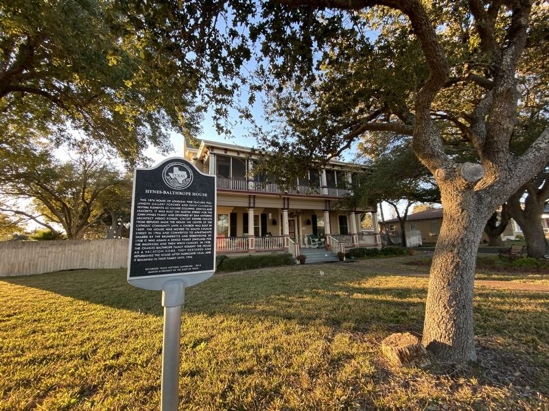
This 1874 house of longleaf pine features full-length gallery porches and such classical revival elements as square columns, dentils and brackets. It was built on Austin Street for the John Hynes family and designed by San Antonio architect Viggo . . . — — Map (db m207827) HM
On North Live Oak Street, on the right when traveling south.
Built around 1910, this two-story frame Colonial Revival was used as a boarding house for shipyard employees. The home was also used for shelter for 50 refugees during the 1919 hurricane that devastated the coast. In 1920, county judge Joe A. . . . — — Map (db m207909) HM
Built in 1903 in Old Rockport, this Cottage and Craftsman Style House is an early frame Bungalow surrounded by giant oak trees. In 1920, W.H. Smith, grandson of early Refugio pioneers, bought this house where he lived with his second wife, their . . . — — Map (db m211222) HM
On North Magnolia Street just north of East Nopal Street, on the left when traveling north.
Tobias “T.R” Wood purchased lots at a sheriff’s auction in 1910 and built this Queen Anne style house. T.R. worked on his father’s cattle ranch located on San Jose Island. When T.R. moved to Victoria to practice law, his brother, Will W. Wood and . . . — — Map (db m212054) HM
On West 1st Street (U.S. 287) at Parks Street, on the right when traveling west on West 1st Street.
Erected in 1953, this building is constructed of stone used to build the first masonry jail in Armstrong County, 1894. Stone for the structure (which replaced a primitive, frame "calaboose") was quarried 14 miles south at Dripping Springs in Palo . . . — — Map (db m96830) HM
On East Main Street (State Highway 36) at South Harris Street, on the left when traveling west on East Main Street.
Situated on land originally granted by the Mexican Government to Austin County pioneer John Nichols. This Vernacular Italianate commercial building was constructed in 1896 by E. Oscar Finn and John Thomas Colleton. E. O. Finn (1866-1945) a native . . . — — Map (db m157539) HM
On East Main Street (Farm to Market Road 529) at North Amthor Street, on the right when traveling west on East Main Street.
Johann Joachim Henrich Frederick (J. H.) Hintz (1841-1920), a native of Ziesendorf, Mecklenburg, Germany, immigrated to the U.S. with his family in 1855. The Hintzes settled in the Millheim area, and Joachim joined the Cat Spring Agricultural . . . — — Map (db m157511) HM
On East O'Bryant Street at South Tesch Street, on the right when traveling east on East O'Bryant Street.
A significant example of the Craftsman bungalow designed by prominent Houston architect Alfred C. Finn, this house is unusual for its one-and-one-half story form. The residence displays hallmark geometric ornamentation broad porches, and a small . . . — — Map (db m157524) HM
On South Bell Street at West Luhn Street, on the left when traveling north on South Bell Street.
The son of a Prussian immigrant, Emil H. Harigel, Sr. (1859-1904) opened a hardware, tinware, and stove emporium in Bellville in 1881. Soon after, he constructed this residence for his wife, Nannie Louise (Lovette), and children. The home features . . . — — Map (db m201989) HM
On Main Street, 0.1 miles west of Fordtran Boulevard (State Highway 159), on the left when traveling west.
This house dates to 1870, when Jacob Ott (1848-1932) began construction on a home with his carpenter neighbor, August Gruensendorf. The bottom story of the two-level structure was used for his baking business and the upper story was Ott's . . . — — Map (db m176213) HM
On Park Road 38, 0.1 miles east of Antonio Martinez Street, on the right when traveling west.
The first known person to occupy the land where the Hill House is located was Judge Robert M. "Three Legged Willie" Williamson. During his ownership, the community of San Felipe de Austin was burned to the ground by order of Moseley Baker, a . . . — — Map (db m202605) HM
On Main Street at West Front Street, on the left when traveling east on Main Street.
German natives F.W. (Fritz) and Carolyn (Krampitz) Hackbarth arrived in Galveston in 1846 with their two sons. They settled in Austin County, where Fritz farmed and ranched, and the couple had four more children, including F.W. Hackbarth, Jr. . . . — — Map (db m162567) HM
On Hardeman Street at Main Street, on the left when traveling north on Hardeman Street.
This house was built in 1901-1902 for H. Schumacher. It was purchased in 1906 by Richard H. Haynes (1875-1942) who, with his father, founded the Haynes (Sealy) Mattress Company in 1909. Local confectionery store owner F.J. Felcman bought the . . . — — Map (db m162558) HM
On 6th Street at Atchison Street, on the right when traveling west on 6th Street.
Completed in 1911 for civic leaders Paul and Mahala Hackbarth, this concrete block house is an unusual example of vernacular architecture. Prominent features include a wraparound porch, Ionic columns on piers, and large wood sash windows. The . . . — — Map (db m162563) HM
On Main Street at Fowlkes Street, on the left when traveling east on Main Street.
German immigrant Adolph H. Preibisch and his wife, Emilie, came to Austin County in 1860. After the town of Sealy developed along the Gulf, Colorado and Santa Fe Railroad, the Preibisches bought property in the new railroad town. In 1885, Adolph . . . — — Map (db m162569) HM
On Farm to Market Road 109, 0.7 miles south of Farm to Market Road 2502, on the right when traveling north.
Originally operated by the John Reichle family, this store opened about 1890. Damaged by a storm about 1900, the original 2-story building was changed to its current 1-story configuration with assymetrical front gables. A full-width porch, and . . . — — Map (db m202529) HM
On Airport Road, 0.1 miles south of Bottle Springs Road, on the right when traveling south.
Colonel John Henry "Jack" Lapham (1885-1956) was a son of a co-founder of the Texas Company (later Texaco). He was living in San Antonio by 1920 and had many business interests, Jack, his wife, Julie Edna (Capen), and their four children all had . . . — — Map (db m163481) HM
This home was constructed in the 1870s by Georgia stonemason James Henry White for Charles F. Schmidtke (1839-1884). A native of Germany, Schmidtke was an early Bandera merchant, grist miller, and lumber mill operator. White's grandson J. Calvin . . . — — Map (db m163287) HM
On Spring Street east of Main Street, on the right when traveling east.
The Bastrop Opera House was constructed in 1889 by D.S. Green and P.O. Elzner. Elzner, a prominent local merchant, became sole owner in 1901. Over the years, it has been the scene of a variety of entertainment shows. Traveling opera and drama . . . — — Map (db m195096) HM
On Wilson Street, 0.1 miles south of Cedar Street, on the left when traveling north.
New York native Henry Crocheron (1806-1873) and his wife Mary Ann Tipple (1816-1888) built this Greek Revival house about 1857. A prominent businessman with interests in lumbering, land, and cotton. Crocheron was one of Bastrop's earliest leaders in . . . — — Map (db m195978) HM
On Church Street at Buttonwood Street, on the right when traveling south on Church Street.
In 1892 the city sold the old Bastrop Academy lot to Dr. Humphrey Powell Luckett (1847-1925) and his wife, Frances "Fannie" (Haynie) (1849-1930). The couple married and moved to Bastrop in 1869, raising five sons. By late 1893, their home designed . . . — — Map (db m65121) HM
On North Main Street, 0.1 miles north of West 2nd Street, on the left when traveling north.
Kentucky native I.B. Nofsinger (1864-1938) came to Texas at the age of 20 and taught school before returning to his home state to study medicine. He was a doctor in McDade (8 Mi. E) prior to moving his practice here. In 1906 he and his wife Mary . . . — — Map (db m205304) HM
On Ramona Street at Northwest 2nd Street, on the right when traveling south on Ramona Street.
Prominent area land developer and merchant J. H. Chancellor (1876-1938) built this residence about 1909. The house was located in the center of Smithville's business district, near the railroad depot and several hotels. It exhibits Classical Revival . . . — — Map (db m160318) HM
On Northeast 4th Street at Olive Street, on the right when traveling west on Northeast 4th Street.
Organized in 1888 by the Rev. H. M. Haynie and eight charter members, the Methodist congregation in Smithville met in the local school until a frame sanctuary was completed in 1893. A new brick structure was built in 1912-13. Following damage in a . . . — — Map (db m160314) HM
On Colorado Street at Burleson Street, on the right when traveling west on Colorado Street.
Virgil Sullivan Rabb, Jr. (1870-1943), came to Smithville in 1891 with his family when his father bought the Calcasieu Lumber Company. The Rabb family had been in this area since receiving land grants in Fayette County in 1823. Rabb ran the lumber . . . — — Map (db m160321) HM
As superintendent of the Beeville school system for 34 years, William Eldridge Madderra (1870-1936) was responsible for much of the development of the town's early educational programs. Madderra, for whom a local school building is named, . . . — — Map (db m212002) HM
On South Main Street (State Highway 317) at Water Street, on the right when traveling north on South Main Street.
Three Bell County courthouses have stood on this site — part of the 120 acres given by Matilda F. Connell Allen for the location of the county seat.
Prior to erection of a courthouse, early official business of the county (created and . . . — — Map (db m201984) HM
On North Main Street (State Highway 317) at East First Ave, on the right when traveling north on North Main Street.
Completed in 1904, this brick library building was funded by a personal contribution from the noted New York industrialist and benefactor Andrew S. Carnegie. Ben D. Lee, builder of the Bell County Courthouse, served as contractor. Designed by the . . . — — Map (db m152196) HM
On Royal Street, on the right when traveling west.
Built in the 1860s, this house was the residence of the Rev. George Washington Baines (1809-83) from 1870 to 1883. A pioneer Baptist preacher, missionary, editor, and educator, the Rev. Baines was the great-grandfather of United States President . . . — — Map (db m29313) HM
Built by Col. E.S.C. Robertson and wife, Mary Elizabeth (Dickey).
Rare ante-bellum plantation complex, comprising home, servant quarters, land, family cemetery, stables. Still a working ranch.
The house, occupied by fifth generation of . . . — — Map (db m29310) HM
On North Main Street (Farm to Market Road 2268) at Blacksmith Street, on the right when traveling north on North Main Street.
E.M. Hutchens married Ruby Vickrey December 31, 1917. Prior to their marriage, Hutchens had attended Salado College from 1913-1917. At that time "Miss Ruby" was head of the piano department. Hutchens had even signed up as a piano student. Later, he . . . — — Map (db m212173) HM
On Bandera Road (State Highway 16) 0.1 miles west of Helotes Canyon Drive, on the right when traveling west.
Ryall Luther White (1878-1962) was born in Jasper, Texas to John Luther Calvin White and Texanna Priscilla Ryall White. He married his wife, Ethel Gertrude Smyth, in 1907 and began working for his father-in-law as the manager of the Uvalde Rock . . . — — Map (db m163142) HM
On Scenic Loop Road at Marnoch Road on Scenic Loop Road.
Scottish surgeon Dr. George Frederick Marnoch (1802-1870) purchased more than 1500 acres at this site in the fall of 1858. In January 1859, Marnoch commissioned famed San Antonio architect and builder John M. Fries to construct this house near . . . — — Map (db m163145) HM
On Washington Circle at Northwest Drive, on the right when traveling east on Washington Circle.
In 1928 the San Antonio Airport Company purchased 2300 acres of land near the city and donated it to the United States Army Air Corps for development of a consolidated flight training facility. Called “The West Point of the Air”, Randolph Field . . . — — Map (db m201912) HM
On King William Street south of Beauregard Street, on the right when traveling north.
Alfred Giles is remembered as a major architect who designed many edifices throughout Texas in the late 19th and early 20th centuries.
Born in 1853 in Hillingdon, Middlesex County, England, Giles spent his early days as an architect's . . . — — Map (db m118800) HM
On King William Street north of Beauregard Street, on the right when traveling north.
This structure has been
recorded by the
Historic American
Building Survey
by the United States Department
of the Interior for its archive
at the Library of Congress — — Map (db m235074) HM
On King William Street at South St. Mary's Stret, on the right when traveling west on King William Street.
After migrating to Texas from his native Germany in 1848, Anton Wulff (1822-1884) became a prosperous San Antonio merchant. He served as a City Alderman and as the first City Park Commissioner. He built this Italianate style home in 1869-1870 for . . . — — Map (db m235049) HM
On Madison Street at East Sheridan Street, on the right when traveling south on Madison Street.
Originally from England, George Stooks Chabot (1821-1902) was a commission merchant dealing in cotton, wool, and hides. He and his wife Mary (Van Derlip) (1842-1929) built this two-story stone house in 1876. The design includes several galleries . . . — — Map (db m235080) HM
On King William Street south of Beauregard Street, on the right when traveling south.
After both of his parents died, four-year-old Charles F.A. Hummel (1854-1935) was adopted by his uncle and aunt, Charles A. and Caroline (Scher) Hummel. Charles F.A. worked with his adoptive father at Charles Hummel and Son Guns and Ammunition. He . . . — — Map (db m235054) HM
On King William Street south of East Sheridan Street, on the right when traveling south.
Former Confederate officer and Virginia state legislator Elias Edmonds married Lucy Noyes Hall in 1871, and they moved to San Antonio that year.
In 1877, they built one of the first houses in the King William neighborhood. Elias was a successful . . . — — Map (db m118798) HM
On Washington Street south of Turner Street, on the right when traveling south.
This house is one of three standing antebellum structures in the King William Historic District.
Gustav Blersch, a German immigrant, importer and retail dealer, built this two-story limestone home in 1860 with designer Gustave Freisleben and . . . — — Map (db m118909) HM
On King William Street at East Johnson Street, on the right when traveling north on King William Street.
Alabama natives Joseph Madison and Birdie Lanier Nix moved to San Antonio in the early 1890s. J.M. was a businessman who built hotels and other structures. In 1899, the couple built twin houses at 434 and 432 King William. The Free Classic design of . . . — — Map (db m235070) HM
Near East Johnson Street west of King William Street, on the right when traveling west.
The river followed an irregular course through the town center and irrigated the lower farmlands of Mission San Antonio de Valero (the Alamo) to the south. After the mission was secularized 1793, the surrounding fields were distributed to . . . — — Map (db m118908) HM
On King William Street at Washington Street, on the right when traveling south on King William Street.
The King William neighborhood is located on the former farmlands of Mission San Antonio de Valero (the Alamo). The 216-acre area, less than one mile from the former mission, includes two National Register districts. It is bounded generally by Cesar . . . — — Map (db m235053) HM
On Madison Street north of Beauregard Street, on the right when traveling north.
Born in 1908, Mary Burkholder moved to San Antonio before 1913. She earned her teaching credentials in 1929 from Our Lady of the Lake College and passionately taught for decades at Jose Navarro Elementary School. In the late 1960s, Mary took on the . . . — — Map (db m235088) HM
On King William Street south of East Johnson Street, on the right when traveling south.
Excellent example of lavish Victorian architecture of late 1800s. Built in 1874 by German immigrant Edward Steves, founder of a family prominent in city financial and social circles.
Stuccoed limestone exterior walls are 13" thick. The . . . — — Map (db m118860) HM
On Madison Street at East Sheridan Street, on the right when traveling north on Madison Street.
Jewish-Russian immigrant Oscar Berman was in Texas by the 1880s. He wed Rachel “Ray” Finklestein c. 1890 and became a businessman in Luling, Caldwell County, partnering with Getzel Zadek. They later opened a wholesale liquor business in San Antonio. . . . — — Map (db m235086) HM
On Madison Street at East Johnson Street, on the right when traveling south on Madison Street.
This 2-story Craftsman style home was built in the early 1920's.
It was the residence of the Riverwalk architect Robert H.H. Hugman
from 1927 through 1930 following his return to San Antonio from
New Orleans, La. In 1929 Hugman proposed his . . . — — Map (db m235081) HM
On Starr Street at Elm Street, on the left on Starr Street.
Anna Barbara (Heiman) (1828-1913) and Johann Engelbert (1821-1915) Heidgen (also Heitgen) came from Prussia to San Antonio in 1852. They bought property at this site, which at the time was on the eastern edge of the Irish Flats neighborhood.
. . . — — Map (db m235106) HM
On 6th Street north of Avenue E, on the left when traveling north.
Built in three stages beginning in 1858, this caliche block vernacular double house sits on a site which was once part of the Alamo farmlands. Reflecting Spanish and German influences, it is a good example of a once-common San Antonio house type and . . . — — Map (db m235149) HM
On Taylor Street north of 3rd Street/East Martin Street, on the left when traveling north.
The three-story limestone Maverick-Carter house was constructed on the north side of San Antonio’s central business district in 1893 for real estate developer William Harvey Maverick, son of Texas Declaration of Independence signer Samuel Augustus . . . — — Map (db m235155) HM
Near West Marten Street at North Santa Rosa Street, on the right when traveling east.
Johann Nicholas Menger (1807-1892), a native of Germany, came to Texas with the Castro Colony and moved to San Antonio in 1847. In 1850 he started a factory that supplied soap for much of the city and southwest Texas. By 1873, Menger had built this . . . — — Map (db m213512) HM
On Commerce Street, on the right when traveling west.
This structure was built to house the San Antonio National Bank, organized by George W. Brackenridge and others in 1866 as the first federally chartered banking institution in the city. Cyrus L.W. Eidlitz, a New York architect, designed the building . . . — — Map (db m30346) HM
San Antonio in the late 1800s was a city quickly changing from a frontier town to a metropolis, soon to become the largest city in Texas, a claim it held for three decades. Mary Francis Drake (1848-1915) arrived in San Antonio in 1890 with her two . . . — — Map (db m179629) HM
On Piazza Italia at Columbus Street, on the right when traveling west on Piazza Italia.
In 1926, at the request of the city's Italian Catholics, Diocesan officials invited the Rev. Saverio Vecchio to preach a mission. As a result, the congregation of San Francesco Di Paola was organized. Designed by Richard Vander Stratten and built . . . — — Map (db m179440) HM
On 6th Street north of Avenue E, on the left when traveling north.
Built in 1890 for San Antonio business and civic leader August Thiele, Jr., this high Victorian raised cottage was designed by noted architect James Riely Gordon. Of particular importance is the structure's outstanding and unusual porch with its . . . — — Map (db m235146) HM
On Auditorium Circle north of Jefferson, on the right when traveling north.
Designed by Ernest P. Behles and built by the Gordon-Jones construction company, the three-story concrete and masonry Toltec apartment house was constructed in 1913 for Dr. Augustus Maverick, who was tragically murdered before its completion. The . . . — — Map (db m235163) HM
Near East Travis Street west of North Saint Mary's Street, on the right when traveling east.
County leaders purchased land on the west bank of the San Antonio River in 1859, intending to build a new courthouse and jail. Their plans changed and the property was sold in 1866 to a miller, Jacob Laux, who dammed the river and built a . . . — — Map (db m119162) HM
On Dwyer Avenue at Old Guilbeau Street, on the right when traveling north on Dwyer Avenue.
This residence was built in 1903 for the William Joske family. The most prominent subsequent owner was William Baker Teagarden (1854-1933). He was an attorney, judge and representative of the Southern Pacific Railroad for many years. The two-story . . . — — Map (db m235038) HM
On East Houston Street at Navarro Street, on the right when traveling east on East Houston Street.
Originally the unpaved El Paseo or Paseo Hondo, Houston Street had developed into San Antonio's premier retail and theater district by the early 20th century. Many spectacular commercial buildings from this era have been preserved. Follow the . . . — — Map (db m227696) HM
On Broadway south of McCullough Avenue, on the right when traveling south.
Fine example of late Victorian architecture. Built 1888-1889 as residence by a leading post-Civil War San Antonio merchant, Saul Wolfson (1830-1923). Constructed of brick with quoined stone corners, ornate carved stone pediments. Lavish interiors . . . — — Map (db m235151) HM
On Leslie Road, 0.1 miles south of Braun Road, on the right when traveling south.
Erected in 1906, the Zion Lutheran Church was designed and built by church members in the uniquely American Carpenter Gothic tradition. Skilled at the construction of houses and barns, the farmers of Helotes created a church building reminiscent . . . — — Map (db m166320) HM
On Crofton Avenue at Constance Street, on the left when traveling north on Crofton Avenue.
Built about 1890, this stately late Victorian house combines various influences and styles. The architect was M. T. Eckles, and builder was T. R. Hertzberg, a local businessman. In 1909 Judge Sidney J. Brooks, noted lawyer and first judge of 57th . . . — — Map (db m235103) HM
On Adams Street north of Stieren Street, on the left when traveling north.
German craftsman Carl Schulze (1861-1917) came to San Antonio in the late 1880s and, with his brother Otto, became one of the town's leading homebuilders. This house, built about 1891, served as a residence for Carl and his wife, Agathe (Sobeczek), . . . — — Map (db m235091) HM
On East Nueva Street at South Alamo Street, on the left when traveling west on East Nueva Street.
Dolores Alderete (d. 1852) had this adobe and cedar post residence constructed about 1818. The widow of Ygnacio Gil, she had earlier received the site as a grant from the Spanish government for the military service of her husband. Originally the . . . — — Map (db m213447) HM
On South Presa Street, 0.1 miles north of East Cesar E. Chavez Blvd, on the left when traveling north.
La Villita neighborhood reflects the influence of immigrants as San Antonio grew, from Spanish settlers in the late 1760s, to German, Swiss and French families coming in the 1840s. Records indicate William and Mary Ann (Mozer) Richter, both German . . . — — Map (db m213307) HM
On San Pedro Avenue at West French Place, on the right when traveling south on San Pedro Avenue.
In 1904 renowned architect Atlee B. Ayres designed this house for the family of May Bock and David J. Woodward, a prominent business man and contractor. May was instrumental in designing the house, working closely with Ayres on the plans. David . . . — — Map (db m176067) HM
On North Saint Mary's Street at Alpine, on the left when traveling east on North Saint Mary's Street.
The idea of a Japanese Tea Garden was conceived by city parks commissioner Ray Lambert in the early 1900s in an effort to beautify the rock quarries which had earlier been abandoned by the San Antonio Portland Cement Company. The brick and stone . . . — — Map (db m214787) HM
Near North Saint Mary's Street, 0.2 miles west of Tuleta Drive.
Vision and creativity changed an abandoned rock quarry into this place of beauty. Love made it a home, sustained it, and preserved it.
For many decades prior to the early 1900's this quarry supplied limestone to the Alamo Cement Company. Park . . . — — Map (db m214842) HM
On Belknap Place at West Russell Place, on the left when traveling north on Belknap Place.
Developer Jay E. Adams came to San Antonio from Denver in 1888 to invest in real estate. His main focus was an area north of the city that he named Laurel Heights. To set the standard for construction, he built this three story Queen Anne-style . . . — — Map (db m176078) HM
On West Park Avenue at Howard Street, on the right when traveling west on West Park Avenue.
A native of North Carolina, Luther Bynum Clegg (1873-1955) founded the San Antonio Printing Company. He commissioned noted architect Harvey Page (1859-1934) to design this house in 1901-02. Page later characterized the residence as one of his most . . . — — Map (db m176133) HM
On East French Place at North Main Avenue, on the right when traveling west on East French Place.
One of several San Antonio suburbs created between 1890 and 1930, Monte Vista has retained much of its historic character from that time. City Brewery president Otto Koehler, oilman Ed Galt, West Texas cattleman Alfred Gage, veterinary surgeon J.C. . . . — — Map (db m213319) HM
On West Ashby Place at Belknap Place, on the right when traveling east on West Ashby Place.
Built in 1901 for German immigrant Otto Koehler (1855-1914), this home was among the first in this area. Koehler, President of the Pearl Brewing Company, employed local architect Carl von Seutter to design the home. One of the most spectacular . . . — — Map (db m176085) HM
On West French Place at Belknap Place, on the right when traveling east on West French Place.
The arrival of the railroad in 1877 led to construction of new residential developments, including this neighborhood overlooking town near San Pedro Springs. W. McLeroy "Roy" Hearne (1873-1917), a cotton broker, and his wife, Madge Houston . . . — — Map (db m176074) HM
On West Huisache Avenue at Howard Street, on the right when traveling west on West Huisache Avenue.
In early 1907, residents of the Laurel Heights area petitioned the Sisters of the Divine Providence, a French religious order to open a neighborhood school. The order already operated four local schools and many more throughout Texas and adjoining . . . — — Map (db m213325) HM
Near Espada Road at Camino Coahuilteca, on the left when traveling south.
Imagine a vast country without highways, walls, or buildings. This was Texas before the arrival of the Franciscans - a great open landscape crisscrossed by nomadic hunters searching for food. Yet, in the span of a single lifetime, Coahuiltecan . . . — — Map (db m215180) HM
On Mission Road at Felisa Street, on the left when traveling south on Mission Road.
This quarry was the source of stone for building Mission Concepción and portions of Mission San José. Indian and Mestizo laborers used picks and axes to cut grooves in the limestone rock, and bars and wedges to pry up the rough blocks. . . . — — Map (db m164050) HM
On Howard Street at West Laurel Street, on the right when traveling south on Howard Street.
Built in 1904, this was the home of merchant, banker, rancher and civic leader Alexander Hart Halff and Alma (Oppenheimer) Halff, both members of prominent local families. This imposing residence was designed by C.A. Coughlin and Atlee B. Ayres and . . . — — Map (db m235185) HM
On Howard Street north of West Maple Street, on the left when traveling north.
Built about 1880 by Ernst Rechel, pioneer music teacher. Restored by Dr. and Mrs. Franz Stumpf.
Recorded Texas Historic Landmark - 1965 — — Map (db m235175) HM
On Broadway at East Hildebrand Avenue on Broadway.
In 1897, the Sisters purchased the 283 acre Fernridge estate from Colonel George W. Brackenridge as the site for a new Motherhouse for the growing Congregation.
The house was renamed the Brackenridge Villa by the Sisters. After 3 years as the . . . — — Map (db m214713) HM
On Broadway at East Hildebrand Avenue on Broadway.
The Chapel of the Incarnate Word was dedicated on May 30, 1907. The Romanesque design by architect F.D. Gaenslen features outstanding stained glass windows created by the Emil Frei studios in St. Louis, Missouri. A place of prayer and celebration, . . . — — Map (db m214707) HM
Built 1859 by Charles Anderson as headquarters for a 1400-acre house ranch. Leaving San Antonio on Civil War's eve, Anderson sold to poet Hiram McLane who lived here 30 years. In 1890 at Alamo Heights' creation, a subdivider named the mansion for . . . — — Map (db m211553) HM
On Augusta Street at Giraud Street, on the left when traveling south on Augusta Street.
The original complex of eight buildings was erected 1851-1882. Main building is largest known Texas structure in French "Pise de Terre" (Rammed Earth) method.
Upon their arrival here in 1851 the Ursuline Nuns found the abandoned, decaying . . . — — Map (db m213516) HM
On Kentucky Avenue at North Calaveras, on the right when traveling east on Kentucky Avenue.
Organized in 1886 as the San Antonio Home for Destitute Children, the Protestant Home for Destitute Children moved into this building in December 1890. The orphanage continued in operation at this site until 1926, when it relocated to larger . . . — — Map (db m176064) HM
On Elm Street at Avenue G, on the right when traveling east on Elm Street.
Sam Ealy Johnson Jr. (1877-1937) and his wife Rebekah Baines Johnson (1881-1958) bought this residence in 1913. Sam, an educator and six-term Texas legislator, and Rebekah, an educator and journalist, raised five children here. The frame house was . . . — — Map (db m30926) HM
On South College Hill Drive at West 9th Street on South College Hill Drive.
Constructed in 1923 as the administration building for the Lutheran College of Clifton, this structure served students and faculty until 1954, when the school merged with Texas Lutheran College in Seguin. The building was sold in 1954 and housed the . . . — — Map (db m233814) HM
On West Magnolia Street west of North Bowie Street, on the right when traveling east.
North Carolina styling and garden plantings were brought to Bowie County when Jas. W. and Laura Williams Jones built this home in 1883.
Recorded Texas Historic Landmark - 1965 — — Map (db m234922) HM
On Walnut Street at West 9th Street, on the right when traveling south on Walnut Street.
Founded in 1883 with the Rev. J. C. Mason as first pastor, the Central Christian Church congregation built this structure in 1932. Construction was supervised by architect and church member E. C. Seibert (1878-1941), who used carefully placed . . . — — Map (db m96569) HM
On East 5th Street at East 5th Street, on the left when traveling east on East 5th Street.
Currently, only Federal office building to straddle state line. Present Texas-Arkansas state boundary (established in 1841 by United States and Republic of Texas) passes through center.
Each state had separate post offices until 1892, when first . . . — — Map (db m96566) HM
On North Velasco Street, on the right when traveling north.
This stone is an original column from the 1895 Brazoria County Courthouse located in Brazoria, Texas. Column donated by Mr. A. T. "Tom" Covert in memory of his beloved wife Georgia City of Angleton Centennial Time Capsule 1892 - 1992 Placed May . . . — — Map (db m173354) HM
On East Locust Street, on the left when traveling east.
Tennessee native Rees P. Sweeny (1856-1937) constructed this raised Victorian house in 1896, the year Angleton became the seat of government for Brazoria County. The county's tax collector from the early 1890s to 1902, Sweeny moved here as part of . . . — — Map (db m173309) HM
Near North Velasco Street, on the right when traveling north.
This structure is the turret from the Brazos Lighthouse erected near the mouth of the Brazos River in 1895-1896 to aid navigation through the newly constructed jetties into the river. Light originally came from an oil lamp producing 35,000 . . . — — Map (db m173314) HM
On FM 521 Road (Farm to Market Road 521), on the right when traveling south.
Home built 1848-1851 by slave labor; materials came by sea, Florida to Velasco, and up the San Bernard River. Recorded Texas Historic Landmark - 1967 — — Map (db m173101) HM
On County Road 316 (Highway 316), on the left when traveling north.
A tanner, John McCroskey came to Texas with Stephen F. Austin's "Old 300". He built this home in compliance with the terms of his 1824 land grant. Later owners remodeled the structure. Oliver Jones, the owner in 1849-50, was chairman of a . . . — — Map (db m173103) HM