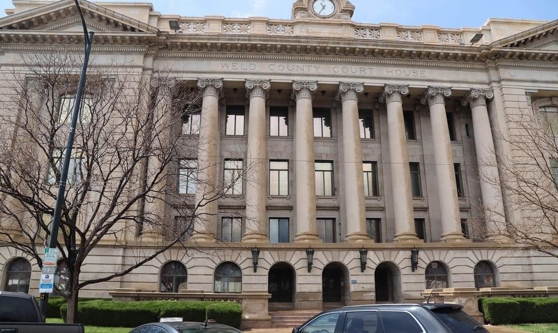
The Weld County Court House was designed by architect William N. Bowman, with construction beginning in 1915 and dedication celebrated on July 4, 1917. The building cost $414,000 and was financed entirely by taxes without a bond issue. The . . . — — Map (db m222032) HM
Near Noble Avenue north of Crown Street, on the left when traveling north.
Our myths and legends about wolves vary from reverence to fear.
753 B.C.
Mother to mythic heroes
According to Roman mythology. Romulus and Remus were nurtured as infants by a "she-wolf." Romulus founded the city of Rome on the Tiber . . . — — Map (db m230843) HM
On Brookside Road just north of Old Kings Highway North, on the right when traveling north.
1894.
On Sunday, July 22, 1781,
while engaged in public worship
in the building then occupying this site
Rev. Dr. Moses Mather
and fifty men of this congregation were captured
by British troops and taken to New York
There . . . — — Map (db m230983) HM WM
On Old Kings Highway North just east of Brookside Road, on the right when traveling west.
Darien's Roots
The Creation of Middlesex Parish
The origins of Darien can be traced to the challenges of a very long walk. In the 1730s residents living in the rural outskirts of Stamford's east end joined forces with their neighbors . . . — — Map (db m230980) HM
Near Old Post Road at Beach Road, on the right when traveling north.
Welcome to Fairfield’s Historic Town Green
How Did This Green Come to Be? Most New England towns began with a central common "green." Where you are standing is Fairfield's historic center and is as old as the town itself. In 1639 Roger . . . — — Map (db m204367) HM
Near Game Cock Road, 0.4 miles east of Ritch Avenue West, on the left when traveling east.
Assisted in 45 felony arrests. Saved the lives of his handler Sgt. Rich Cochran and another police officer.
February 1988 - August 1996
— — Map (db m193152) HM
On Grove Street at Prospect Street, on the right when traveling south on Grove Street.
The Home of George G. Scott, located on Prospect Street, was razed in 1964 to make way for Ridgefield Arms, the first apartment complex to be built in Ridgefield. Scott, a descendant of the original Scott family was Judge of Probate . . . — — Map (db m230133) HM
On Farmington Avenue (Connecticut Route 4) north of Walnut Street, on the left when traveling north.
During the week of August 12, 1955, the Farmington Valley was hit by the edge of Hurricane Connie. The area received heavy rainfall that saturated beds of the Farmington River. The following week, Hurricane Diane swept through the Atlantic Coast, . . . — — Map (db m230293) HM
On Church Street at Court Street, on the right when traveling north on Church Street.
[ south side ]
“Make Us Free”
This monument is a memorial to the 1839 Amistad Revolt and its leader, Sengbe Pieh, also known as Joseph Cinque. Sengbe Pieh was one of the millions of Africans kidnapped from their homes and . . . — — Map (db m48428) HM
On this site, September 30, 1858, Police Court Judge Augustus H. Brandegee and Customs Collector John Perkings Mather freed a stowaway slave known as “Joe” by applying Connecticut’s Personal Liberty Law against the federal Fugitive Slave Act. Judge . . . — — Map (db m66445) HM
Near Mohegan Ave. Pkwy. north of Williams Street, on the right when traveling north.
Academy Plaza
Academy Plaza is dedicated to that high sense of honor, respect and devotion to duty which is such an integral part of the United States Coast Guard Academy and which makes it so unique. The Academy is much more than an outstanding . . . — — Map (db m205854) HM
Near Mohegan Ave. Pkwy. north of Williams Street, on the right when traveling north.
We stood in youthful ranks near this spot sixty years ago, not knowing for whom the building behind us was named. After four intense years studying "Seamanship, Sciences and the Amenities" we mustered here again for our commencement portrait. We . . . — — Map (db m205503) HM
Near Mohegan Ave. Pkwy. north of Williams Street, on the right when traveling north.
An Act of the First Congress, August 4, 1790 An act to provide more effectually for the collection of the duties imposed by law on goods, wares and merchandise imported into the United States, and on the tonnage of ships or vessels. Be it . . . — — Map (db m205822) HM
On this site, August 29. 1839, federal investigative inquiry indicted 38 enslaved Mende Africans accused of revolt on the high seas and murder of the Captain and cook of the Spanish slave ship Amistad which was captured and brought into New London . . . — — Map (db m66444) HM
Near Mohegan Ave. Pkwy. north of Williams Street, on the right when traveling north.
George Washington, Prefident of the United States of America To all who shall see these presents, greeting.
Know Ye, That repofing fpecial Trust and Confidence in the Integrity, Diligence and good Conduct of Hopley Yeaton of New . . . — — Map (db m205250) HM
Near Mohegan Ave. Pkwy. north of Williams Street, on the right when traveling north.
Honor
“I…would willingly risk my life, tho’ not my character, to exalt my station” Letter from the Antilles, 1769 (aged 12)
Duty
“A few armed vessels, judiciously stationed at the entrances to our ports, might at a small expense be made . . . — — Map (db m205499) HM
Near Mohegan Ave. Pkwy. north of Williams Street, on the right when traveling north.
Revenue Cutter Scammel
Commanded by Captain Hopley Yeaton, whom
President George Washington commissioned as
The Revenue Marine's very first officer.
Scammel was second of ten "armed vessels, judiciously stationed" envisioned by . . . — — Map (db m205506) HM
On Bank Street west of Golden Street, on the right when traveling east.
On May 29, 1919, an hours-long brawl between Black and white Navy sailors erupted at the Hotel Bristol at 92 Bank Street. With five thousand people surrounding the hotel, the New London police and fire departments were unable to control the crowd . . . — — Map (db m217020) HM
Near Mohegan Ave. Pkwy. north of Williams Street, on the right when traveling north.
To Alexander Hamilton from George Washington
October 6, 1790
Mount Vernon Octr 6th 1790.
Sir,
Not being possessed of any commissions, I have to request (unless your farther enquiry should point to more proper characters) that you will . . . — — Map (db m205249) HM
Near Mohegan Ave. Pkwy. north of Williams Street, on the right when traveling north.
To George Plater from George Washington May 14, 1789 Dear Sir, I foresaw the numerous applications which would be made for nominations to offices — and readily conceived that amidst the variety of candidates, it would be one of the most delicate . . . — — Map (db m205253) HM
Near Mohegan Ave. Pkwy. north of Williams Street, on the right when traveling north.
To George Washington from Hopley Yeaton December 11, 1789
Sir, Permit an inferior Officer in rank, tho' not inferior in Affection for you in your high Sphere, or for my Country's welfare, amidst the great concerns of a happy Continent, who . . . — — Map (db m205251) HM
Near Mohegan Ave. Pkwy. north of Williams Street, on the right when traveling north.
Captain Hopley Yeaton
Portsmouth, New Hampshire
1740 — 1812
A Patriot of 1776
In the War of American Independence
Captain Yeaton was active with the
Sons Of Liberty
As an officer he served with distinction
in the Continental . . . — — Map (db m205823) HM WM
On Jonathan Trumbull Hwy. (Connecticut Route 87) at Middletown Road (Connecticut Route 66), on the right when traveling north on Jonathan Trumbull Hwy..
Near Fisher Avenue, 0.2 miles north of Mispillion Street, on the left when traveling north.
Milford Parks and Recreation Director, Gary L. Emory, sits on the bank of Goat Island in the Mispillion River (1981). In the background the newly constructed Milford Police Department can be seen. Goat Island was the first parcel of land acquired by . . . — — Map (db m198909) HM
On Willow Grove Road (Delaware Route 10) at Henry Cowgill Road (Delaware Route 10), on the left when traveling north on Willow Grove Road.
Samuel D. Burris, a free African-American conductor on the Underground Railroad resided in the Willow Grove area during the 1840s. He helped enslaved people find their pathway to freedom in Philadelphia. Caught for aiding and abetting runaway slaves . . . — — Map (db m142503) HM
On Greenbank Rd, 0.1 miles west of Albertson Dr., on the right when traveling east.
Completed in 1901, the New Castle County Workhouse at Greenbank was named the first penal institution in the United States to employ armed female guards. Nicknamed "Annie Oakleys" for their excellent shooting ability with the machine guns and rifles . . . — — Map (db m195007) HM
On McKennans Church Road, on the left when traveling north.
Farmland along McKennans Church Road, formerly owned by the Wells and Gregg families, was acquired by the New Castle County Workhouse at Greenbank circa 1915-16 and named Delcastle Farms. Located approximately two miles from the main prison . . . — — Map (db m145624) HM
On North French Street north of East 8th Street, on the right when traveling north.
In memory of the 6,000,000 men, women, and children, victims of hatred whom the Nazi's brutally murdered only because they were Jews.....
and the world remained silent. — — Map (db m215951) WM
On Gilpin Avenue east of North Dupont Street, on the right when traveling north.
Thomas Patrick Conaty, Jr. was born in Wilmington on March 12, 1916. He was raised by Irish immigrant parents on Gilpin Avenue in the Forty Acres. A bright student and an outstanding athlete, he graduated from Salesianum where he excelled in . . . — — Map (db m216056) HM
Near Kirkwood Highway (Delaware Route 2) at Newport Gap Pike (Delaware Route 41), on the right when traveling west.
On June 23, 1903, George White, a black farm laborer, was lynched near this site by a mob of white citizens. After being accused of murdering a white girl on June 16, Mr. White was taken to the New Castle County Workhouse to await trial. On
June . . . — — Map (db m195011) HM
On Coastal Highway (Delaware Route 1) south of Lighthouse Road (Delaware Route 54), on the right when traveling south.
The smallest, flattest and driest continent on earth is about the same size as the United States. Settled 200 Years ago by a contingent of outcasts and criminals from Great Britain, Australia is now populated by 16 million "ockers" and ten times . . . — — Map (db m206327) HM
On The Circle (U.S. 9) at North Bedford Street (Delaware Route 18/404), on the left when traveling south on The Circle.
"The Man"
Chad E. Spicer was born August 23, 1980 at Beebe Medical Center, Lewes, DE. Son of Norman and Ruthann. He resided in Georgetown, Delaware his whole life. His parents provided a very good home life for him teaching him right from . . . — — Map (db m190435) HM
On Union Street (Delaware Route 5) north of Chandler Street, on the right when traveling south.
Bryan Stevenson grew up in Milton, Delaware. A widely acclaimed public interest lawyer, he is the Founder and Executive Director of the Equal Justice Initiative, and has dedicated his career to helping the poor, the incarcerated, and the condemned. . . . — — Map (db m232898) HM
In the early 1800s the headquarters of the notorious Cannon/Johnson Kidnapping Gang was located close to this site. After the importation of African slaves was legally outlawed in 1808, demand for slave labor in the expanding states of the Deep . . . — — Map (db m67262) HM
On Russell Road just west of Evergreen Road, on the right when traveling west.
1952: Mr. & Mrs. Richard Hall purchase 130 acres and name it South Bethany
1952: Construction of the South Bethany canals begins and lasts until 1962
1959: Property owners number 500
1962: "The Perfect Storm" aka . . . — — Map (db m150152) HM
On Russell Road just west of Evergreen Road, on the right when traveling west.
[This marker features a series of photos with captions:]
Richard Hall's field office was the home of the South Bethany Association before citizens voted for incorporation in 1969 and the town government was formed.
The town hall . . . — — Map (db m150156) HM
On 1st Place Northeast south of Riggs Road Northeast, on the right when traveling north.
The Washington Metropolitan Area Transit Authority Board of Directors, in recognition of the contribution of Officer Marlon Morales, who through courage and valor gave his life for the mission of Washington Metropolitan Area Transit Authority and . . . — — Map (db m110847) HM
On Quebec Street Northwest at Porter Street Northwest on Quebec Street Northwest.
In honor of those who risked their lives to save Jews during the Holocaust
1992 Jan Karski Poland •
1993 Preben Munch-Nielsen Denmark •
1994 . . . — — Map (db m150711) HM WM
On Constitution Avenue Northwest (U.S. 1/50) at 10th Street Northwest, on the right when traveling west on Constitution Avenue Northwest.
The roots of America's top law enforcement agency, the Department of Justice, reach back to 1789. That year the first Congress created the Office of the Attorney General to prosecute lawsuits in the Supreme Court and advise the President and . . . — — Map (db m57214) HM
On Pennsylvania Avenue Northwest at 10th Street Northwest, on the right when traveling east on Pennsylvania Avenue Northwest.
The Federal Bureau of Investigation is headquartered across Pennsylvania Avenue from this spot. Thanks to popular media, it may be one of the better-known government agencies. Since the 1930s Hollywood has found great stories among the . . . — — Map (db m57218) HM
On Constitution Avenue Northwest (U.S. 1/50) west of 12th Street Northwest, on the right when traveling west.
The U.S. Environmental Protection Agency is the youngest agency housed here in the Federal Triangle. Established as an independent agency in 1970, EPA protects human health and the environment through science, transparency, and the rule of . . . — — Map (db m57211) HM
On 14th Street Northwest south of D Street Northwest, on the right when traveling north.
Across the street the Department of Commerce's Herbert C. Hoover Building anchors the Federal Triangle, just as the department - with its mission of promoting trade, supporting economic development, and strengthening the competitiveness of . . . — — Map (db m57204) HM
On Constitution Avenue Northwest (U.S. 1/50) east of 12th Street Northwest, on the right when traveling west.
While only Congress — the people's elected representatives — can impose taxes and decide how they are spent, the Internal Revenue Service, a bureau of the U.S. Treasury, ensures those taxes are collected fairly and efficiently. The IRS . . . — — Map (db m57212) HM
On 23rd Street Northwest south of D Street Northwest, on the right when traveling north.
The Department of State is the nation’s oldest and senior cabinet agency. It was established by Congress in 1789 to conduct America’s diplomatic relations.
The State Department represents U.S. interests to foreign governments, promotes peace, . . . — — Map (db m40248) HM
On Q Street Northwest at Q Street Northwest, on the right when traveling west on Q Street Northwest.
Police call boxes like this one were used in this neighborhood from the 1920s to the 1970s by the Metropolitan Police to call in reports. (In older parts of Washington, police call boxes were used as early as the 1880s.) Each officer had a key to . . . — — Map (db m187488) HM
On Beecher Street Northwest at 42nd Street Northwest, on the left when traveling west on Beecher Street Northwest.
Police and fire call boxes were installed throughout Washington, D.C. neighborhoods to provide emergency communication links between neighborhood streets and local police and fire stations. With the introduction of the 911 emergency call system in . . . — — Map (db m113379) HM
On Hall Place Northwest at Wisconsin Avenue Northwest, on the left when traveling east on Hall Place Northwest.
Police and fire call boxes were installed throughout Washington, D.C. neighborhoods to provide emergency communication links between neighborhood streets and local police and fire stations. With the introduction of the 911 emergency call system . . . — — Map (db m113384) HM
On F Street Northwest west of 4th Street Northwest, on the right when traveling east.
This Memorial was established by the National Law Enforcement Memorial Fund, as directed by an Act of the United States Congress.
The authorizing law was sponsored by U.S. Representative Mario Biaggi and U.S. Senator Claiborne Pell, and was . . . — — Map (db m65404) HM
On Constitution Avenue Northwest (Alternate U.S. 1) at Pennsylvania Avenue Northwest, on the right when traveling west on Constitution Avenue Northwest.
We hold these truths to be self-evident. That all men are created equal, that they are endowed by their creator with certain unalienable rights, that among these are life, liberty & the pursuit of happiness. That to secure these rights, governments . . . — — Map (db m130132) HM
On Mount Pleasant Street Northwest at Kenyon Street Northwest, on the right when traveling south on Mount Pleasant Street Northwest.
Harry Townsend, who passed away at the age of 102 in 2004, had lived in the 1700 block of Kenyon Street since 1956. He was a well-known local figure who worked in construction. Townsend was still helping neighbors with repairs at age 90. . . . — — Map (db m179596) HM
On Kennedy Street Northwest just west of 4th Street Northwest, on the right when traveling east.
This mural created by Shirien Damra and United We Dream commemorates the very first Immigrant Day of Resilience on April 15, 2021.
On this day, we honor Edder, Joella, Satsuki, and the millions of resilient immigrants in the United States . . . — — Map (db m201675) HM
On Tracy Place Northwest at 24th Street Northwest on Tracy Place Northwest. Reported damaged.
Three chief justices of the Supreme Court lived in Sheridan-Kalorama. William Howard Taft, appointed Chief Justice after his presidency, lived at 2215 Wyoming Ave. Charles Evans Hughes, a U.S. Secretary of State and an unsuccessful candidate for . . . — — Map (db m112605) HM
On U Street Northwest east of 13th Street Northwest, on the left when traveling west.
In honor of Metro Transit Police Officer Marlon Francisco Morales, who was mortally wounded at the U Street/African American Civil War Memorial/Cardozo Metrorail Station on June 10, 2001. — — Map (db m15473) HM
On Ohio Drive Southwest north of Buckeye Drive Southwest, on the right when traveling north.
The building in front of you serves as headquarters for the United States Park Police. Created by President George Washington in 1791, the U.S. Park Police functions as a unit of the National Park Service with jurisdiction in all parks. U.S. Park . . . — — Map (db m65403) HM
Near Raoul Wallenberg Place Southwest south of Independence Avenue Southwest, on the left when traveling north.
Panel 1:
Dedicated in gratitude to the Supreme Commander of Allied Forces in Europe, General Dwight David Eisenhower and the valiant soldiers of all Allied Armies he led into battle.
Victorious in battle, they brought the Third Reich . . . — — Map (db m48459) HM
On South Main Street (Florida Route 329) just south of East University Avenue (Florida Route 24/26), on the right when traveling north.
Lynching in America
After the Civil War, constitutional rights were granted to Black people ensuring equal protection and voting. Many white leaders responded to the emancipation of Black people by violently seeking to maintain racial, . . . — — Map (db m186407) HM
On Newberry Lane at NW 245 Street, on the left when traveling west on Newberry Lane.
Lynching in America
Between 1877 and 1950, thousands of African Americans were the victims of lynching and racial violence in the United States. Florida had one of the highest per capita lynching rates in the nation, with dozens of racial . . . — — Map (db m186426) HM
On Northwest 166th Street at Northwest 20th Avenue, on the left when traveling north on Northwest 166th Street.
Side 1
On August 19, 1916, African Americans living in the Jonesville and Newberry communities were lynched. At 2:00 a.m., Constable George Wynne, Dr. L.G. Harris, and G.H. Blount drove to Boisey Long's home in Jonesville to serve a warrant and . . . — — Map (db m135956) HM
On South Lowder Street, 0.1 miles south of W Railroad Avenue.
In honor of
Colonel John (1831-1891) and Clara H. Darby (1838-1880)
Founders of Darbyville
and son, Arthur Morgan and Ida Lee Wolfe Darby
Children: Ada Darby Jones, Susie Darby Marks, John Morgan
Darby, Mira Darby Peek, Mable Lee . . . — — Map (db m206764) HM
On Harmon Avenue at East Second Place, on the right when traveling north on Harmon Avenue.
This house was built in 1908 by Miles Lampkin "Lamp" and wife Mary Honora "Nora" Purcell Harmon. "Lamp", born in 1871, was the son of original settlers Turner Hunt and Nancy Harmon. "Lamp" was one of the thirty one qualified voters that signed the . . . — — Map (db m245197) HM
Near Freedom Avenue, 0.3 miles south of Parker Street, on the left when traveling south.
On Aug. 20, 1955, Emmett Till, a 14-year old Black youth from Chicago arrived in Money, Mississippi by train, along with a cousin, 16-year old Wheeler Parker Jr. They had accompanied Till’s great uncle and Parker’s grandfather, Moses Wright, who . . . — — Map (db m179240) HM
On Freedom Avenue, 0.3 miles south of Parker Street, on the left when traveling south.
The July 16, 1949, a 17-year-old white woman and her estranged husband reported to police that she had been abducted at approximately 2:30 a.m., driven approximately 25 minutes to a dead-end road, and raped by four black men. By the end of the . . . — — Map (db m179835) HM
Near Freedom Avenue, 0.3 miles south of Parker Street, on the right when traveling south.
It was August 27, 1960, a day that became known as “Ax Handle Saturday.” The violent attack was in response to peaceful lunch counter demonstrations organized by the Jacksonville Youth Council of the National Association for the Advancement of . . . — — Map (db m181942) HM
Coral Ridge Properties built the City's first real estate office in 1964 at the intersection of Route 441 and Wiles Road, just outside the City limits. This 30-by-20 foot single-room wooden structure displayed maps and plats of subdivisions, none of . . . — — Map (db m47421) HM
On McClellan Avenue, 0.1 miles north of Black Avenue, on the right when traveling north.
The Southland Trail Cemetery, believed to be a non-white cemetery, serves as the final resting place for an undisclosed number of leased convict laborers, blacks and possibly 18th century Spanish-Indian fishermen. The age of the cemetery is unknown; . . . — — Map (db m151056) HM
On Ponce de Leon Parkway, 0.5 miles south of North Marion Court, on the right when traveling south.
Many wading birds can be seen here, largely due to the sacrifice of men like Columbus G. McLeod (1848-1908), who gave his life trying to protect them from plume hunters. Ladies' hats with exotic bird feathers were high fashion for the late 1800's, . . . — — Map (db m167589) HM
On West Main Street (Gulf to Lake Highway) (State Road 44) west of North Osceola Avenue, on the right when traveling west.
This two story wood frame Colonial Revival style residence features a beautiful verandah best suited for socializing on warm summer evenings was built in 1903, by James Keels Kelley. According to a 1936 Citrus County Chronicle article, J.K. Kelley . . . — — Map (db m126053) HM
On West Main Street (Gulf to Lake Highway) (State Road 44) at South Seminole Avenue, on the right when traveling east on West Main Street (Gulf to Lake Highway).
This house was built in 1903 for George Carter, Citrus County's third sheriff. The Carter House was the first house in Inverness to have a bathroom and was one of the first 13 buildings in Inverness to be “wired up” when electricity came . . . — — Map (db m126060) HM
Guy Bradley is one of the heroes of Audubon and one of the most colorful characters of its history. He was the first warden to be deputized by Audubon, a strange fact due to his passion for hunting birds for their valuable, fashionable plumes. When . . . — — Map (db m164913) HM
The Rhett Green tree is an iconic, massive individual, rugged like its namesake. It has withstood the test of time. In 1912, Rhett Green was hired as an Audubon warden to protect plume bearing birds such as egrets, herons and roseate spoonbills . . . — — Map (db m164914) HM
On North Jefferson Street south of West 4th Street, on the left when traveling north.
The Jefferson Street Pool was the first major municipal facility of its kind available to African Americans in Jacksonville. Prior to its establishment in 1951, a few community pools for black people had been created.
The Jefferson Street Pool . . . — — Map (db m237299) HM
A native of Maine, Ebenezer Dorr spent fourteen months as a prisoner of war in England during the War of 1812. He was captain of his own ship for many years, trading at ports around the world. In about 1827,
Dorr moved his family to Escambia County . . . — — Map (db m80050) HM
On South Tarragona Street south of Church Street, on the right when traveling south.
Texas fugitive, John Wesley Hardin (1853-1895) was captured here on August 23, 1877. Hardin was wanted and dangerous, and his capture became national news that brought notoriety to Pensacola. Hardin had reportedly killed 27 men. He bragged he had . . . — — Map (db m91105) HM
On East Zarragossa Street at South Jefferson Street, on the right when traveling east on East Zarragossa Street.
Side 1
Old Escambia County Court of Record Building (1912-1978)
During the early 1900s, the Florida Legislature established a new court of record to serve the rapidly-growing Escambia County. Completed in 1912, this Neo-Classical . . . — — Map (db m146500) HM
On Avenue A N (St. James Avenue) (U.S. 98) west of Tallahassee Street (Marine Street), on the right when traveling west.
Carrabelle, Florida Home of the… World’s Smallest Police Station
In 1947, Albin Westberg became Police Chief and the only day policeman in Carrabelle. He and his night officers had to protect the citizens, answer calls, pump water for . . . — — Map (db m131800) HM
On Doyle Carlton Drive at West Laurel Street, on the right when traveling south on Doyle Carlton Drive.
Lynching in America
Between 1877 and 1950, thousands of African-Americans were the victims of lynching and racial violence in the United States. Florida had one of the highest per-capita rates of Black victims lynched by white mobs, including . . . — — Map (db m206382) HM
On North Pierce Street at East Madison Street, on the left when traveling south on North Pierce Street.
Born in West Tampa in 1938 to immigrants from Spain, Judge E.J. Salcines is widely admired for his professionalism and leadership in the administration of justice spanning almost fifty-five years. A graduate of Florida Southern College and South . . . — — Map (db m215682) HM
On West Main Street just east of South Sinclair Avenue, on the right when traveling east.
In July 1949, Walter Irvin, Samuel Shepherd, Charles Greenlee and Ernest Thomas — known collectively as the "Groveland Four" — were accused of crimes in Lake County. Eyewitness accounts, records, and subsequent investigations revealed . . . — — Map (db m145768) HM
Near South Gadsden Street at East Gaines Street, on the left when traveling south.
On March 17, 1960, a county judge sentenced seven Florida A&M University students and one high school student to pay $300 or spend 60 days in jail for “sitting in” at the Woolworth lunch counter. They chose jail over bail. Their courage sparked a . . . — — Map (db m230666) HM
Near South Gadsden Street at East Gaines Street, on the left when traveling south.
The Leon County Jail once stood on this very spot. Law enforcement imprisoned local activists here for peacefully challenging segregation. Many of them chose to stay in jail instead of paying bail. Their willingness to suffer unjust punishment . . . — — Map (db m230646) HM
Near South Gadsden Street at East Gaines Street, on the left when traveling south.
It took three years of economic and political pressure to desegregate Tallahassee’s downtown lunch counters. Afterward, in 1963 activists turned their attention to the city's segregated movie theaters. Hundreds of students protested, and law . . . — — Map (db m230697) HM
Near South Gadsden Street at East Gaines Street, on the left when traveling south.
On May 26, 1956, two female Florida A&M University students broke the law by refusing to move to the back of a crowded bus. The police arrested them. Tallahassee's African American community responded by boycotting city buses for seven months until . . . — — Map (db m230657) HM
On East Gaines Street at South Meridian Street, on the right when traveling east on East Gaines Street.
Lynching in America
Between 1877 and 1950, thousands of African Americans were victims of mob violence and lynching across the United States. Following the Civil War, white Southerners fiercely resisted equal rights for African Americans and . . . — — Map (db m186412) HM
On Pine Avenue at Crescent Drive, on the right when traveling south on Pine Avenue.
The Historical Society of Anna Maria Island Museum
Built in 1920 as an ice house on 402 Pine Avenue, the building was subsequently used as city hall, the police department, a firehouse and the Turtle House before the Society renovated . . . — — Map (db m72447) HM
Near Manatee Avenue West (Florida Route 64) at 12th Street West, on the left when traveling west.
Chips Shore (1941-2015) was the Manatee County Clerk of Circuit Court and Comptroller for 38 years (1977-2015). He was very proud to be a native of Manatee County, Florida and loved the outdoor environment that makes our community unique. He knew . . . — — Map (db m217044) HM
On SW St. Lucie Avenue at SW Seminole Street on SW St. Lucie Avenue.
Have you ever had a vacation that was so great you didn't want to go home? That's what happened to President Grover Cleveland when he visited Stuart in 1899. The President had such a good time fishing here that he bought a lot just north of where . . . — — Map (db m193644) HM
On SE Ocean Boulevard (State Road A1A) at SE Denver Avenue, on the right when traveling east on SE Ocean Boulevard.
The Peter Montague & Lord Baltimore
Chapters of the National Society Colonial Dames XVII Century mark this Martin County Court House to commemorate the historical significance of this site to Martin County, Florida and its people. Built in . . . — — Map (db m193667) HM
On Northwest 5th Avenue at Northwest 11th Street, on the right when traveling north on Northwest 5th Avenue.
In 1944, the City of Miami hired its first five black police officers who were sworn in as "emergency patrolmen" to enforce the law in what was then called the Central Negro District. These stalwart men were Ralph White, Moody Hall, Clyde Lee, . . . — — Map (db m228930) HM
Livingston Bethel was two years old when his father, Judge Winer Bethel, moved from Nassau, Bahama Islands, to Key West. He was educated in a private school in Key West at the Walnut Hill Military Academy in Geneva, New York. He read law under Homer . . . — — Map (db m223659) HM
Near Fleming Street west of Whitehead Street, on the left when traveling west.
The first Monroe County jail dates back to 1828. Built two years after the county courthouse, it was a symbol of Monroe County's position as the largest city in Florida. The jail was rebuilt in 1835, 1845,1880, 1892, and 1907. During the 1907 . . . — — Map (db m243929) HM
Near Wall Street at Tift’s Aly, on the left when traveling north.
John Maloney Spottswood was born in Key West in 1920, educated in Monroe County and graduated from Riverside Military Academy. During World War II, he served in the US army. He established the first Key West radio station in September 1945. In March . . . — — Map (db m222861) HM
At the end of 1822, mere
months after the first US flag
was planted in Key West,
Commodore David Porter was
sent to take charge. Porter
commanded the West Indian
Squadron nicknamed the
"Mosquito Fleet". Porter was
ordered to end the reign . . . — — Map (db m192412) HM
On Wall Street at Tifts Street, on the right when traveling north on Wall Street.
War on Drugs
Key West's strategic position on the Straits of Florida between the Caribbean Sea, the Gulf of Mexico, and the Atlantic Ocean makes it a critical location for the war on drugs.
The island has played a vital role in . . . — — Map (db m224220) HM
On South 3rd Street at Cedar Street, on the right when traveling south on South 3rd Street.
The Old Nassau County Jail has occupied several buildings on this site from 1878 through 1978. In 1868, the Nassau County Board of County Commissioners began the process of creating a stand-alone jail, and in 1871, the deed for this property was . . . — — Map (db m154094) HM
On East Kennedy Boulevard at Gabriel Street, on the right when traveling east on East Kennedy Boulevard.
The first police station was built circa 1912 under Mayor John Hurston. Several buildings were built and continuously renovated. A holding section (jail) was housed within the police station until circa 1971.
The current police station is . . . — — Map (db m196530) HM
1977 entries matched your criteria. Entries 201 through 300 are listed above. ⊲ Previous 100 — Next 100 ⊳