On Fourth Street, 0 miles north of Severn Avenue when traveling north. Reported damaged.
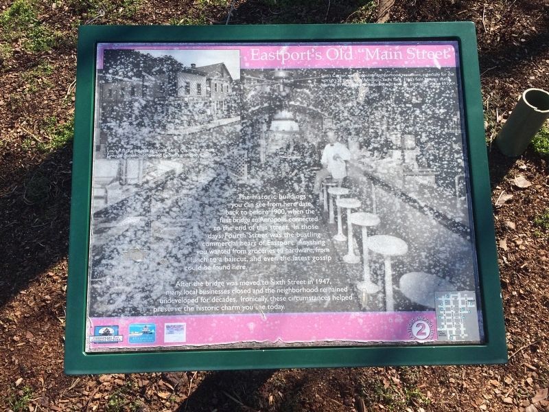
The historic buildings you can see from here date back to before 1900, when the first bridge to Annapolis connected to the end of this street. In those days, Fourth Street was the bustling commercial heart of Eastport. Anything you wanted from . . . — — Map (db m114860) HM
On Third Street at Chester Avenue, on the right when traveling north on Third Street.
Many African-American families settled here more than a century ago. these families, who have lived here for four generations, are the heart and soul of this neighborhood. Their religious, educational and cultural institutions are pillars of . . . — — Map (db m5653) HM
On First Street at Jeremy's Way, on the right when traveling north on First Street.
You are standing at the corner of "Murphy's Row." These ten row houses were built in 1888 by Charles James Murphy for laborers employed at his company, the Annapolis Glass Works.
The houses bear witness to Eastport's early years. The seventh . . . — — Map (db m170217) HM
On Severn Avenue at Second Street, on the left when traveling east on Severn Avenue.
The private home at the corner of Severn Avenue and Second Street was once the head office for one of Eastport's largest businesses. The Annapolis Glass Works - later the Severn Glass Company - produced china, glass and pottery from 1885 to 1902. . . . — — Map (db m5887) HM
On Eastern Avenue at Third Street, on the left when traveling west on Eastern Avenue.
Prestigious sailboat racing events have made Annapolis famous. But the real reason for Annapolis' reputation as "America's Sailing Capital" is the community of Eastport. There are more marine-related businesses here than anywhere on the East Coast . . . — — Map (db m5727) HM
On First Street, 0.1 miles Severn Avenue, on the left when traveling north.
This is where Eastport's famed boat building industry began. On this site in 1868, a German immigrant named Wilhelm Heller began crafting fine wooden boats. His reputation spread and business flourished. Heller's became the largest boatyard on Spa . . . — — Map (db m5734) HM
On Chester Avenue at Fourth Street, on the right when traveling south on Chester Avenue.
During the 1920s, the houses on this street belonged to African-American families. Most of the men living here worked on the water, launching often home-built boats from their back yards. They harvested oysters from September to April, and crabs in . . . — — Map (db m5650) HM
On Severn Avenue, 0 miles east of Third Street, on the left when traveling east.
As you walk among these buildings, imagine wooden boats taking form. Picture men sweating in the hot sun as they plank a hull, caulk a seam or varnish a rail. Envision Navy officers in khaki uniforms boarding vessels for sea trials. From 1913 to . . . — — Map (db m170216) HM
On 6th Street, 0.1 miles north of Severn Avenue, on the right when traveling north.
Eastport's distinctive history, character and identity grew from maritime roots. The marinas that now serve pleasure boaters were once filled with wooden workboats. So crowded was the shoreline, it was said that an enterprising cat could flit from . . . — — Map (db m5890) HM
On Second Street at Bay Shore Avenue, on the left when traveling south on Second Street.
Eastport's distinctive history, character and identity grew from maritime roots. The marinas that now serve pleasure boaters were once filled with wooden workboats. So crowded was the shoreline, it was said that an enterprising cat could flit from . . . — — Map (db m5891) HM
Near Londontown Road, 1.3 miles north of Mayo Road (Route 253).
[photo of plants and tools] Early medicinal plants and tools
Colonial Medicine Chest
Where did the colonial doctor or housewife turn when they needed to treat the sick? The plants of the field, hedgerow and marsh were their pharmacy. . . . — — Map (db m22138) HM
Near Londontown Road, 1.3 miles north of Mayo Road (Route 253).
Scattered Settlements
Early Chesapeake Bay colonists did not settle in the concentrated villages typical of their home in England. Instead, they lived on large plots of waterfront land that isolated them from their neighbors.
Cheap and . . . — — Map (db m22112) HM
Near Londontown Road, 1.3 miles east of Mayo Road (Route 253).
From London Town, and original port of entry, a ferry crossed South River. It linked a north-south system of roads from about 1695 until the 19th century. — — Map (db m3419) HM
Near Londontown Road, 1.3 miles east of Mayo Road (Route 253).
Has been designated a Registered National Historic Landmark under the provisions of the Historic Sites Act of August 21, 1935. This site possesses exceptional value in commemorating or illustrating the history of the United States. — — Map (db m3420) HM
Near Londontown Road, 1.3 miles north of Mayo Road (Route 253).
The ravine in front of you was once Scott Street. Rumney's Tavern, the Brown Carpenter Shop and the Brown House are on this side of the street. On the other side were a number of structures, some of which were commercial enterprises such as . . . — — Map (db m22141) HM
Near Londontown Road, 1.3 miles north of Mayo Road (Route 253).
A Transportation Network
Ferries were a critical link in the colonial road system. The ferry crossing at London Town was part of a larger transportation network that extended from Virginia to New York, moving people and goods to market along . . . — — Map (db m22143) HM
Near Londontown Road, 1.3 miles north of Mayo Road (Route 253).
Location, Location, Location
One of the mysteries that still surrounds the lost town of London is the William Brown House. Built between 1758 and 1764 overlooking the South River, William Brown intended it to serve as his dwelling and an . . . — — Map (db m22137) HM
On Huber Road at Ernie Pyle Street, on the right when traveling north on Huber Road.
In compliance with instructions contained in a letter from Adjutant General of the Army, dated March 17, 1924, a School for Bakers and Cooks was established at Camp Meade in April of that year. Throughout its existence at the post, the school's . . . — — Map (db m19702) HM
On English Avenue, 0.2 miles south of Mapes Road, on the left when traveling south.
Dedicated September 14, 1986 to commemorate the Becentennial of the Annapolis Convention, September 11-14, 1786.
Delaware, New York, Virginia, New Jersey, Pennsylvania
Commission on the Bicentennial of the Constitution of the United . . . — — Map (db m19629) HM
Imagine life in the Carrie Weedon house in 1901. Kerosene lamps provided light for reading, sewing, or playing the piano. Water came from an outdoor hand pump. A privy, a small barn, and a shed were located out back. Food was grown in the garden or . . . — — Map (db m6200) HM
The members of the Galesville Heritage Society invite you to explore their historic village. First settled in 1654 on the banks of West River, Galesville and its history are fundamentally linked to the Chesapeake Bay. Native Americans, English . . . — — Map (db m6201) HM
Near Church Lane south of Main Street (Maryland Route 255).
Alice Wayson Hartge was the wife of Cap'n Oscar and the mother of eleven. When Oscar took over the boat yard in 1934, she became the bookkeeper, time keeper, and bill payer. Having the only phone in the area, any calls required her to blow a . . . — — Map (db m130030) HM
On Davidsonville Road (Maryland Route 424) 0.5 miles north of John Hanson Highway (U.S. 50), on the right when traveling north.
600 acres patented in 1664 to Mareen Duval, Esq., great Hugenot and native of France. Appointed Commissioner for Advancement of Trade 1683, he died here 1694. The plantation remained the ancestral seat of a junior branch of the Duvall family for . . . — — Map (db m43527) HM
On Governor Ritchie Highway (Maryland Route 2) 0.1 miles north of Furnace Branch Road (Maryland Route 270), on the right when traveling north.
The Curtis Creek Furnace, located on the south side of Furnace Creek, one-half mile east of Ritchie Highway, was established in 1759 and with a foundry built in 1829, continued to turn out high grade charcoal pig iron until abandoned in 1851. — — Map (db m2867) HM
On Crain Highway (Business Maryland Route 3) 0.1 miles south of Baltimore Annapolis Boulevard (Maryland Route 648), on the right when traveling north.
The Curtis Creek Iron Furnace (also calle Aetna or Etna Furnace), established c. 1759, stood on the south side of Furnace Branch Creek in Glen Burnie, where Rte. 10 now crosses. The location ensured access to local iron ore deposits, wood from . . . — — Map (db m98379) HM
Near Ritchie Highway (Maryland Route 2) at Aquahart Road when traveling south.
This site was originally settled in 1649 and was known as the Westminster parish. About 1780 it was the property of Francis Cromwell, a cousin of the monarch of England. It was obtained by the Curtis Creek Mining Co. in 1850 from the estate of John . . . — — Map (db m14158) HM
On Elm Road west of West Nursery Road, on the right when traveling east.
In the 1950's there were seven batteries of Nike Ajax anti-aircraft missiles located around Baltimore to protect the city, Friendship Airport, and various industrial sites, as well as the Aberdeen ordnance and Edgewood chemical facilities from . . . — — Map (db m131626) HM
On Kinder Farm Park Road, 0.4 miles west of Gail Sanchez Way, on the left when traveling west.
Sawmills were originally powered by water, making ownership of a mill difficult for those who could not harness water power. In the 1880's, smaller sawmills that could be run by steam engines began to be manufactured. Many companies began to . . . — — Map (db m145230) HM
Near Kinder Farm Park Road, 0.3 miles west of Jumpers Hole Road, on the left when traveling west.
Once harvested, tobacco leaves were placed on stakes and then hung across large poles from the ceiling down, to cure or dry and preserve the leaves. Curing was accomplished by a variety of ways, including using heated metal pipes or flues, wood . . . — — Map (db m99088) HM
Near Chesapeake Bay Drive at John Downs Loop, on the right when traveling west.
During the period 1913 to 1937 this property was the summer estate of H.R. Mayo Thom. In Mother's Garden was this thatched roof gazebo. The gazebo was built by Reginald Giddings, a handyman who worked or the Thoms. Mr. Giddings was an Englishman . . . — — Map (db m147654) HM
On WB&A Road at Donaldson Avenue (Maryland Route 174), on the right when traveling north on WB&A Road.
WB&A Road was constructed on the right-of-way of the main line of the Washington, Baltimore & Annapolis Electric Railroad. Using the most advanced technology of the time, the high-speed line provided passenger and freight service between Baltimore . . . — — Map (db m35050) HM
On Earleigh Heights Road, 0.2 miles west of Ritchie Highway (Maryland Route 2), on the left when traveling west.
Earleigh Heights Store. Historic Home of Charles J. and Mary Novak Katlic and their children Marie, Charles, Eveylyn, James, Helen, Margie and Elizabeth. — — Map (db m2898) HM
In 1889, business partners Gustav T. Hetschel and Henry Frost established a general store and post office just steps away from the Annapolis and Baltimore Short Line Railroad. This new rail service connected the state's economic and political . . . — — Map (db m239533) HM
On East West Shady Side Road west of Bast Avenue, on the right when traveling north.
The story of the Captain Salem Avery House mirrors that of Shady Side and the larger history of the Chesapeake Bay region.
1860-1921 The Avery Family Home
In the mid-19th century, a young man came to Shady Side from New York to . . . — — Map (db m130026) HM
On East West Shady Side Road west of Bast Avenue, on the right when traveling north.
I drew it up, most of the time on a piece of plywood, so it wouldn't get wrinkled up, and I'd use the measurements from that. I always liked to build boats, and I like to change the style of them and try to get something to look pretty good. . . . — — Map (db m130019) HM
On East West Shady Side Road west of Bast Avenue, on the right when traveling north.
This cannon stood guard over the grounds of the Rural Home Hotel for seven decades at a time when visitors flocked to Shady Side to enjoy summers on the Chesapeake.
How did this War of 1812 cannon end up here in Shady Side?
In the . . . — — Map (db m130024) HM
On East West Shady Side Road west of Bast Avenue, on the right when traveling north.
You just can't put your line in any place and get a crab. You got to know where they are. I could give some people my boat and line, but they'd starve to death. You have to have a feel for it.
— George Procter, age 83 . . . — — Map (db m130016) HM
On East West Shady Side Road west of Bast Avenue when traveling north.
I haven't seen 15 bushels of clams in so long... You do worse more days than you do better. Nature can't put it back as fast as man takes it away.
— Ellsworth Brown, clammer, age 55 (1977)
Eeling
Bay . . . — — Map (db m130006) HM
On East West Shady Side Road west of Bast Avenue, on the right when traveling north.
He had powerful arms, shoulders, and hands. Pulling and hauling on nets all of his life, his hands were huge. He was a waterman.
— Howard Shenton, age 67 (1986)
The Catch
Fishing has been a year-round . . . — — Map (db m130007) HM
On East West Shady Side Road west of Bast Avenue, on the right when traveling north.
When you got into Baltimore, you'd fall short maybe twenty-five, thirty bushel…'Cause they took a good round bushel, you know, out of it. And this is life, the way we lived it.
— Erwood Avery, Age 84 . . . — — Map (db m130018) HM
On East West Shady Side Road west of Bast Avenue, on the right when traveling north.
Then I took up oystering, went on the water oystering, and, oh my, I stayed out there and worked, and worked, and worked.
— Julius Dennis, age 88 (1984)
Scooping and Raking — Tonging and Dredging
To . . . — — Map (db m130012) HM
On East West Shady Side Road west of Bast Avenue, on the right when traveling north.
A bad day on the water is better than the best day on land.
— J.R. Gross, age 32 (2000)
To make a living, a waterman thinks not in terms of weekly paychecks but rather, how much his family will bring in during the . . . — — Map (db m130004) HM
On East West Shady Side Road west of Bast Avenue, on the right when traveling north.
For tonging oysters —
the best built boat there ever was…
— Kenneth Nieman, age 72 (1984)
In 1933, a boathouse on Parrish Creek in Shady Side, Captain Perry Rogers built the deadrise on display for . . . — — Map (db m130020) HM
Near East West Shady Side Road west of Bast Avenue, on the right when traveling north.
Erosion has dramatically altered the waterfront you see — washing away more than 200 feet of land in Captain Avery's "front yard." It is said that the Avery family had to move the house back three times in the years they owned it. The original . . . — — Map (db m130022) HM
On East West Shady Side Road west of Bast Avenue, on the right when traveling north.
The house Salem Avery built for his family in 1860 still exists today, but you have to look closely to see it.
The original home was modest and had only one room with a loft. Imagine the building in front of you reduced to just the colored . . . — — Map (db m130002) HM
On East West Shady Side Road west of Bast Avenue, on the right when traveling north.
The Captain Avery Museum is a place to discover Chesapeake Bay life — past, present, and future. This property, first developed in the 1850's, has been continuously owned by the people connected to the water by occupation, recreational . . . — — Map (db m130001) HM
Innovative wholesale merchant to the South and collector of Old Master paintings. As a philanthropist, he inaugurated the system of matching charitable grants. — — Map (db m6568) HM
On West Lanvale Street, on the right when traveling east.
From 1894 to 1899, this house was the residence of Ottmar Mergenthaler, a German immigrant who revolutionized the art of printing with his invention of the Linotype. Previously a typesetter searched for a single character, then placed it in a line . . . — — Map (db m6582) HM
On Dolphin Street at Bolton Street, on the right when traveling west on Dolphin Street.
William Gailes Contee and Edward Wilson Parago, Sr.
Contee-Parago Park is one of the first City parks to be named after Black Baltimoreans: Edward Wilson Parago, Sr. (1898-1983), a postal worker, and William Gailes Contee, an upholsterer . . . — — Map (db m212325) HM
Thomas J. O’Neill 1849-1919-Founder of O’Neill & Company Department Store. He left the business to his employees. He bequeathed the funds that built Good Samaritan Hospital and the Cathedral of Mary Our Queen. — — Map (db m142861) HM
On West Lexington Street west of North Eutaw Street, on the right when traveling west.
The merchant mix at Lexington Market has always included large numbers of immigrant-owned businesses, dating back to the Market's founding. Early records depict a melting pot of business owner nationalities—from German-owned butcher shops to Italian . . . — — Map (db m243487) HM
On West Lexington Street just west of North Eutaw Street, in the median.
Lexington Market is a place nearly as old as America itself—and its history of local food, community-rooted small business, and a space for all is the legacy we are proud to continue on today. Taking a walk through Lexington Market's . . . — — Map (db m243489) HM
On West Lexington Street just west of North Eutaw Street, on the left when traveling west.
Slavery and a domestic slave trade formed essential aspects of nineteenth-century Baltimore life. Some businesses used slave labor, but most slaves worked as domestic servants for elites. In Lexington Market's precinct, for example, one in four . . . — — Map (db m243485) HM
On West Lexington Street at North Paca Street, on the left when traveling east on West Lexington Street.
Back when Lexington got its start in the late 1700s, it sat on the western edges of Baltimore City, the perfect destination for rural farmers to bring their fresh produce and sell to city dwellers. Some traveled by horse-drawn wagon for over three . . . — — Map (db m243474) HM
On West Lexington Street at North Paca Street, on the left when traveling west on West Lexington Street.
In 1886 at the age of 19, John W. Faidley went into business with fish dealer Peter B. Smith, opening as Smith & Faidley—now known simply as Faidley's. Faidley's granddaughter, Nancy Devine, and her husband, Bill, continue to operate what is the . . . — — Map (db m243469) HM
On West Lexington Street just west of North Eutaw Street, on the right when traveling west.
Over the years, the Market has had at least 10 different buildings and countless carts and stalls from the vendors on the street. At times, sheds of wood, stone, and concrete have stretched entire city blocks. Lexington Market's heart and soul, . . . — — Map (db m243488) HM
On West Lexington Street west of North Eutaw Street, on the left when traveling west.
In a different time, Lexington Market was not only the place to get wild caught seafood from the Chesapeake Bay, but also wild game caught by hunters and trappers up and down the East Coast. In the late 1800s, market goers could get all manner of . . . — — Map (db m243529) HM
On West Lexington Street east of North Paca Street, on the right when traveling east.
Beginning in 1963, Market shoeshine vendor James B. Carpenter starts a daily tradition of ringing a bell that hung on Eutaw St. outside of Lexington Market at 8am sharp to signal the start of the market day.
[Caption:]
James . . . — — Map (db m243477) HM
On West Lexington Street at North Eutaw Street, in the median on West Lexington Street.
Casting a light on the identities of two enslaved persons mentioned in 1830s-era Baltimore newspaper announcements, this piece cues onlookers to a history of Lexington Market, and more specifically, pays homage to those who had been assertively . . . — — Map (db m243524) HM
On West Lexington Street west of North Eutaw Street, on the right when traveling west.
The lore of Lexington Market has always loomed almost as large as its public market prowess. From myths of catacombs under the old West Market (really tunnels used by butchers and produce vendors for cold storage before modern refrigeration), to the . . . — — Map (db m243479) HM
On West Lexington Street at North Eutaw Street, on the right when traveling west on West Lexington Street.
Seafood—especially varieties caught right in the Chesapeake Bay—has always been front and center at Lexington Market. For more than a hundred years (from 1820s to 1920s), there was a dedicated market shed building at Lexington devoted only to . . . — — Map (db m243490) HM
On West Baltimore Street west of North Eutaw Street, on the left when traveling east.
Maryland toll roads helped revolutionize American travel. The Baltimore and Frederick-Town Turnpike began with a tollgate, placed near this corner in 1807. For a few cents, you could head west on a "smooth" road that was the ancestor of today's . . . — — Map (db m243468) HM
On West Lexington Street just east of North Paca Street, on the right when traveling east.
From 1975 to 2016, they repeatedly make a pilgrimage to the market for "Lunch with the Elephants," an annual event with Ringling Bros and Barnum & Bailey Circus.
[Caption:]
Elephants chow down on a feast at Lexington Market—a . . . — — Map (db m243476) HM
On O'Donnell Street. Reported permanently removed.
Captain John O’Donnell, the founder of the Canton Community, was a man of great vision and accomplishment. He initiated trade between Canton, China and Baltimore in 1785 operating his own merchant sailing vessels. This public square once the site . . . — — Map (db m184475) HM
On O’Donnell Street at Potomac Street, in the median on O’Donnell Street.
Through the efforts of the Canton Improvement Association this old and densely populated ethnic neighborhood was named to the National Register of Historic Places in 1978. The two-story red brick row houses are especially noteworthy for their hand . . . — — Map (db m184476) HM
On Boston Street at South Clinton Street, on the right when traveling east on Boston Street.
Capitalist cooper purchased the captain John O'Donnell estate 3000 acres in Canton in 1920 and helped in funding the Canton Company of Baltimore that acted as a real estate and development company in transforming the Canton Company into a . . . — — Map (db m190368) HM
Near Boston Street at Potomac Street, on the right when traveling east.
The Pennsylvania Railroad used this railroad transfer bridge to land cars that were transported on ferries between Locust Point and Canton. Known as "carfloating," this activity occurred in the Baltimore Harbor from 1871 to 1969. This two-story . . . — — Map (db m212895) HM
On Boston Street at South East Street, on the right when traveling east on Boston Street.
Capt. John O'Donnell, considered the founder of Canton, made his fortune trading in East Asia. Around 1875, he settled in the Canton area and named his plantation after the port city of Canton, China. Capt. O'Donnell became an enslaver, and the . . . — — Map (db m212897) HM
On Baltimore Waterfont Promenade east of Boston Street, on the right when traveling east.
Harnessing the power of nature to help keep the Baltimore Harbor clean
The amazing machine you see before you uses a combination of old and new technology to harness the power of water and sunlight to pick up litter and debris flowing down . . . — — Map (db m212890) HM
On Boston Street west of South Lakewood Avenue, on the right when traveling east.
Harris Creek
The Harris Creek was once an above ground stream large enough to sail a ship in. It was filled in to make more land for development in the early 1800s. It is now completely piped underground, but it continues to run through . . . — — Map (db m212889) HM
On Boston Street just east of South Kenwood Street, on the right when traveling east.
Douglass escaped slavery with a bold plan, a clever disguise, steady nerves, and help from his friends.
At the age of 20, Frederick Bailey (as he was called) lived under slavery in Fell's Point, one mile west of this marker. He was . . . — — Map (db m212894) HM
On Washington Boulevard at Bush Street, on the right when traveling south on Washington Boulevard.
For more than one hundred years Carroll Park has served the historic Washington Village/Pigtown neighborhood, whose rowhouses once provided lodging for workers employed at the B&O Railroad, streetcar maintenance barns across the street (now used . . . — — Map (db m220061) HM
In 1760, Mount Clare was built as the summer home of Charles Carroll, Barrister. Mount Clare was the center of Georgia, Charles Carroll’s 800-acre Patapsco River Plantation. The estate supported grain fields and grist mills along the Gwynn’s Falls, . . . — — Map (db m61209) HM
Near Washington Boulevard, on the right when traveling south.
In the late 1760’s, the Mount Clare mansion was built by Charles Carroll, Barrister and his wife, Margaret Tilghman, as their summer home. The mansion was located on the grounds of the original plantation, Georgia, and included an orangery, . . . — — Map (db m2533) HM
Near Frederick Avenue (Maryland Route 144), on the right when traveling west.
The Ellicott Driveway portion of the Gwynns Falls trail follows the route of a millrace that carried water to a flour-milling complex owned by the Ellicott family. In the 1800s, 26 gristmills along the Gwynns Falls and other on the Jones Falls . . . — — Map (db m5533) HM
Here at this narrow point in the Gwynns Falls the historic Baltimore and Frederick Turnpike crossed the Gwynns Falls. The Ellicott family built the road to connect Baltimore with the wheat fields and mills to the west. The Ellicotts acquired the . . . — — Map (db m102586) HM
On Greenspring Avenue north of Pimlico Road, on the left when traveling north.
This stone house, commonly known as the “Carroll Hunting Lodge,” is one of the oldest in the Mount Washington area, dating from about 1790. It stands on what was once a vast tract owned by Charles Carroll of Carrollton. Carroll was on the four . . . — — Map (db m114584) HM
“Ruscombe” (meaning brown hill) was built in 1866 by James Wood Tyson, the younger brother of Jesse Tyson who built the nearby Cylburn Mansion. By the 1860’s, the Tyson dynasty, long one of Baltimore’s pre-eminent Quaker and . . . — — Map (db m114587) HM
On East Baltimore Street at South Calvert Street (Maryland Route 2), on the right when traveling east on East Baltimore Street. Reported permanently removed.
On this site in 1900 was constructed the banking headquarters for the Alex Brown Investment Banking Company, America's oldest banking house in continuous operation.
This building survived the Great Baltimore Fire of 1904 with evidence of . . . — — Map (db m7042) HM
On South Calvert Street (Maryland Route 2) at East Baltimore Street, on the left when traveling north on South Calvert Street. Reported permanently removed.
This building was home to Alex. Brown & Sons Company, founded in 1800, the first and oldest continually operating investment banking firm in the United States. The building represents the firm's and Baltimore's importance in the financial world of . . . — — Map (db m7041) HM
On East Baltimore Street west of South Street, on the right when traveling east.
At this site on August 14, 1874, the American District Telegraph Company of Baltimore city was founded to provide messenger services to homes and businesses. Customers used a call box to summon a messenger boy who delivered and responded to . . . — — Map (db m237127) HM
On South Eutaw Street at West Lombard Street (U.S. 40), on the right when traveling north on South Eutaw Street.
Once known as the Bromo Seltzer Tower, this building is a monument to Captain Isaac Emerson, the imaginative chemist who developed a famous headache remedy, and named it after Mt. Bromo - an active volcano in Java.
Emerson came to Baltimore in . . . — — Map (db m6982) HM
On Water Street east of Commerce Street, on the left when traveling east.
Until the 1850's, Baltimore's grain trading took place in "counting rooms" of individual merchants or on Bowley's Wharf where an effort was made to standardize corn and grain prices by displaying grain samples on barrel heads and window ledges. . . . — — Map (db m127236) HM
On West Saratoga Street at Charles Street, on the right when traveling west on West Saratoga Street.
City Center, also known as Charles Center, was transformed in the 1950's to be Baltimore's central business district. City Center has been the fastest growing residential neighborhood since 2000. Learn more about the Resident Life at the City Center . . . — — Map (db m210766) HM
Started 10-48 A.M.
February 7 1904
Under control 11-30 A.M.
February 8 1904
Property destroyed - $100 000 000
Insurance paid - $32 000 000
Acres covered - 140
Lives lost - none
Beginning at Liberty and German Streets the fire . . . — — Map (db m7321) HM
On West Lexington Street east of North Howard street, on the left when traveling east.
On this site, from 1886-1908, stood the Beehler Umbrella Factory, the oldest umbrella house in America. Founded in Baltimore by Francis Beehler in 1828. — — Map (db m4895) HM
On North Charles Street, on the left when traveling north.
Named for the governor who developed it, Brown's Arcade is a unique and early example of adaptive reuse in Baltimore. The four buildings that make up the Arcade were originally constructed as rowhouses in the 1820's. After the Great Fire of 1904, . . . — — Map (db m5565) HM
On West Saratoga Street at Charles Street, on the right when traveling west on West Saratoga Street.
The building Brown's Loft Apartments, located here at 300 N Charles St, was built in 1875. Historically the building served many functions, most notably housing the YMCA. The mixed-use building now features 39 stunning loft style apartments and . . . — — Map (db m210767) HM
On North Charles Street at East Baltimore Street on North Charles Street.
Twice in the 20th century, Baltimoreans completely reinvented their downtown-by necessity in the early 1900s and by plan mid-century.
In 1904, Baltimore’s downtown vanished when 140 acres were destroyed by fire. Within ten years, Baltimore had . . . — — Map (db m103262) HM
On Commerce Street south of Holliday Street, on the left when traveling south.
Built between 1904 and 1905, this Renaissance Revival building was once the commercial hub of Baltimore's grain trade. Standing five-stories tall and extending the length of a city block, the building was home to the Baltimore Chamber of Commerce, . . . — — Map (db m127235) HM
On North Charles Street at West Lexington Street when traveling south on North Charles Street.
The 14-block Charles Center project, begun in 1958, was the first piece of Baltimore's nationally recognized downtown Renaissance. the 33-acre project was strategically placed between the financial district on the east side and the retail . . . — — Map (db m88236) HM
On North Calvert Street (Maryland Route 2), on the right when traveling north on North Calvert Street.
The Continental Trust Building, constructed in 1902, is the only building in Baltimore designed by Daniel H. Burnham, a major figure in the Commercial Style that developed in Chicago at the turn of the century and produced the American skyscraper. . . . — — Map (db m6442) HM
On East Baltimore Street at South Calvert Street on East Baltimore Street.
Baltimore’s central business district has constantly reinvented itself in response to changes in building technologies, business practices, and architectural styles. Originally,
detached houses that doubled as shops and offices lined the streets. . . . — — Map (db m103260) HM
1305 entries matched your criteria. Entries 101 through 200 are listed above. ⊲ Previous 100 — Next 100 ⊳