Welcome to Downtown Baltimore-a unique City with southern charm and northern distinction.
Known the world over for being friendly and hospitable, it’s no wonder Baltimore is often referred to as “Charm City.” A place which takes a . . . — — Map (db m103921) HM
When constructed in 1870, the Faust Brothers Building incorporated the latest innovations in building construction methods and materials. The building’s intricate front and rear facades, composed entirely in cast iron, were once common in . . . — — Map (db m101784) HM
Baltimore's first fish market stood near the site of this structure as searly as 1773. The first market building, Centre Market, was authorized by act of the State legislature in 1784. It was also known as Marsh Market since it was built on Thomas . . . — — Map (db m7322) HM
"There is hardly a building in Baltimore that doesn't contain something we made, even if it is only a nail." So boasted Theodore Krug, heir to the oldest continuously working iron shop in the country. For more than 170 years artisans here have . . . — — Map (db m6619) HM
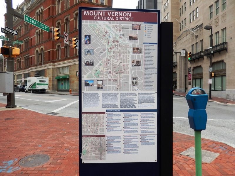
Saratoga Street marks your arrival at Cathedral Hill, a neighborhood packed with three centuries of architecture. In the late 18th and early 19th centuries, Baltimoreans built some of their finest mansions and churches on Cathedral Hill. Today’s St. . . . — — Map (db m103844) HM
A pioneer art historical and scientific museum. Erected 1818 by Rembrandt Peale. Gas lighting demonstrated june 13 1816. Occupied as city hall 1830-1875. Rembrandt Peale 1778-1860 Distinguished Maryland artist, naturalist and technologist . . . — — Map (db m6306) HM
This imposing building, appropriately designed by Joseph Evans Sperry to suggest an old treasure chest, is the home of Provident Savings bank, the father of branch banking among mutual savings banks of the nation. Incorporated in 1886 with the . . . — — Map (db m6653) HM
Rembrandt Peale, founder of the Gas and Light Company of Baltimore (now Baltimore Gas and Electric Company), was a famous portrait painter from Bucks County, Pennsylvania. He had a unique and groundbreaking connection to Baltimore.
In 1816, to . . . — — Map (db m101657) HM
Maryland toll roads helped revolutionize American travel. The Baltimore and Frederick-Town Turnpike began with a tollgate, placed near this corner in 1807. For a few cents, you could head west on a “smooth” road that was the ancestor of today’s . . . — — Map (db m5700) HM
This building was home to Alexander Brown & Sons Company, founded in 1800 as the first investment banking firm in the United States. Douglas Thomas designed the building in the popular Beaux-Arts style and the building was constructed in 1901. It . . . — — Map (db m183359) HM
This building, designed in 1889 in the Richardson-Sullivan tradition by Charles L. Carson and Joseph Evans Sperry, was considered the first skyscraper to be erected in Baltimore. It is the oldest of the existing structures on Monument Square and . . . — — Map (db m6443) HM
The Equitable Building, designed in 1889 in the Richard-son-Sullivan tradition by Charles L. Carson and Joseph Evans Sperry, was considered the first skyscraper to be erected in Baltimore. It is the oldest of the existing structures in . . . — — Map (db m232408) HM
This 13-story building, completed in 1913, was designed by Baltimore architects J. B. Noel Wyatt and William G. Nolting. Reflecting a mixture of styles, this transitional building combines the Chicago windows, flat wall panes and flat skyline . . . — — Map (db m7040) HM
Rising ten stories in the heart of the city’s judiciary district, the Lenore not only exhibits impressive architecture but is also linked to the nation’s banking history. Now an apartment building, the Lenore was once home to the Baltimore Branch . . . — — Map (db m101527) HM
When this structure was completed in 1911, it was Baltimore's tallest office building. Of steel construction, faced with Bedford limestone on the lower floors, and brick and terra cotta above, the building stands as a monument of sorts to the whims . . . — — Map (db m7319) HM
This structure is the oldest museum building in the United States. Designed by Robert Cary Long, Sr. for Rembrandt Peale, the museum opened to the public in 1814 as "an elegant Rendezvous for taste, curiosity and leisure." For a 25-cent admission . . . — — Map (db m6305) HM
The first franchise in America to produce and distribute gas for public use was granted in 1816 by this city to the Baltimore Gas Light Company, established by Rembradnt Peale, William Lorman, James Mosher, Robert Cary Long and William Gwynn. In . . . — — Map (db m7318) HM
The Westside of Downtown Baltimore boasts an astonishing variety of architectural styles from early 19th century Federal townhouses to Reconstruction-era cast-iron facades to Art Deco storefronts. The one-time heart of the City, the Westside's . . . — — Map (db m115207) HM
Elephants, giraffes, and many other animals at the Zoo regard tree branches the way you might regard a salad—a delectable dose of plant-based nutrition. These herbivores, or plant eaters, browse branches, eat leaves, and chew soft . . . — — Map (db m212312) HM
All birds lay eggs and incubate them until they hatch. For penguins, sitting on a nest keeping eggs warm and dry is problematic because to do so, they must temporarily leave the ocean. African penguins gather in breeding colonies on rocky, . . . — — Map (db m212303) HM
On June 23, 2000, the Treasure, a large iron-ore tanker, sank in rough waters off the coast of South Africa, dumping over 1,300 tons of oil and diesel fuel into the ocean. More African penguins were impacted by this oil spill than by any other in . . . — — Map (db m189063) HM
Many animals in the Zoo's Farmyard exhibit represent rare livestock breeds. Modern food production now favors the use of a few highly specialized breeds. As a result, some livestock breeds are becoming increasingly rare. . . . — — Map (db m212311) HM
In Latin, lemur means "ghost."
In Malagasky folklore, lemurs appear as sacred spirits never to be harmed.
In reality, lemurs are wide-eyed prosimian primates facing an uncertain future.
Lemurs inhabit the . . . — — Map (db m212313) HM
It is difficult to know how many okapi are still living in Congolese rainforests, but by all estimates, their numbers are declining. To save okapi, we need to preserve and protect their shrinking habitat.
Okapi population decline
2000: . . . — — Map (db m189106) HM
Survival in the Wild
When fish are scarce, African penguins must keep on swimming.
There are not as many fish in the Benguela Current as there used to be, due in large part to years of unregulated commercial fishing. Food . . . — — Map (db m189062) HM
African elephants have suffered tremendous losses over the past century due to poaching. In some regions, though, elephant populations are finally rebounding. How can we continue to tip the balance in their favor?
Why are elephants . . . — — Map (db m189090) HM
On the islands and shorelines where African penguins breed, they face tough environmental conditions. For thousands of years, the penguins escaped sun, wind, rain, and predators inside cave-like nests that they constructed from guano — poop from . . . — — Map (db m189051) HM
"There are birds as big as ducks but they cannot fly and they bray like asses."
This description of African penguins — the earliest known — was written in 1497 by a crew member accompanying the famed Portuguese . . . — — Map (db m212304) HM
This property is listed on the National Register [of Historic Places]
as part of
Federal Hill
National Historic District
and is registered with the
Preservation Society — — Map (db m240365) HM
Since the founding of Baltimore, 1729, this hill has been a popular point for viewing the city’s growth. Here 4,000 people feasted 1780, to celebrate the ratification by Maryland of the Federal Constitution and in honor of the new government gave . . . — — Map (db m2555) HM
Lady Maryland is an authentic reproduction of a Chesapeake Bay pungy schooner. Beginning in the early 19th century, pungies were considered to be among the fastest of all Bay watercraft, and were frequently used to carry perishable . . . — — Map (db m219646) HM
Sigsbee is a Chesapeake Bay skipjack, a vessel designed and built specifically to dredge for oysters on the Bay. Once numbering in the thousands, only a handful of skipjacks survive today. Together, they constitute the last sailing . . . — — Map (db m219651) HM
For the past 300 years, wharfs have jutted into Baltimore harbor, and been home to commercial and residential buildings. What is known today as Chase’s Wharf, where you are standing, had long been a bustling site with one and two-story frame and . . . — — Map (db m103331) HM
For the past 300 years, wharves have jutted into Baltimore's Harbor to accommodate commercical and residential buildings. The grounds where you stand have long been a bustling site with one and two-story frame and brick buildings dating . . . — — Map (db m219611) HM
In the early 1780s Ann Bond Fell Giles laid out for development the area called Fell's Point, just south of the existing Fell's Prospect community. Development was in part to provide housing needed to meet the demands of the growing maritime . . . — — Map (db m109369) HM
Frederick Douglass is one of the best known Americans of the 19th century. Countless schools, churches, and other community buildings across the United States have been named after him. Known for his bravery, vision, and insightfulness, Douglass . . . — — Map (db m219626) HM
In memory of
Edward Fell
Maryland 1723 from Lancaster, England. Acquired land, Jonestown. Later part of Baltimore Town. Importer, died 1743.
William Fell
Brother of Edward. Maryland 1730. Married Sarah Bond 1732. Acquired thousand . . . — — Map (db m145477) HM
This property was once known as City Dock, which was built in the early 1830s and used by ship and rail merchants. Living Classrooms Foundation, in partnership with Baltimore City, began to revitalize what is now the Living Classrooms East Harbor . . . — — Map (db m145577) HM
The National Brewing Company of Baltimore, MD first introduced the National Bohemian brand as we know it today in January, 1934. Often referred to as Natty Boh, the brand has been in continuous production ever since. Mr. Boh, the mustachioed, . . . — — Map (db m109879) HM
On September 22 of 2007 record store owners from all over the USA gathered here in Fell's Point to create Record Store Day.
It is now the world's largest music event.
Record stores can't save your life. But they can give you a . . . — — Map (db m114574) HM
A national heritage site, the Frederick Douglass-Isaac Myers Maritime Park celebrates African-American who worked on Baltimore’s maritime trades in the 1800s. It also tells the stories of Frederick Douglass and Isaac Myers, who worked as chandlers . . . — — Map (db m102951) HM
During the early 1800s, shipyards dotted Baltimore’s Harbor. Many of them drew vessels in need of repair from waters up and down the Atlantic coast. Repairs ranged from minor sail mendings to complicated restorative hull work rendered by skilled . . . — — Map (db m103411) HM
During the early 1800s, shipyards dotted Baltimore's harbor, drawing vessels in need of repair from waters up and down the Atlantic coast. Skilled shipwrights and carpenters performed a range of repairs from minor sail mending to complicated . . . — — Map (db m219640) HM
Built in 1765 by a young Fell's Point merchant, this House is Baltimore's oldest surviving urban residence. The furnishings in the parlor are the Maryland State Society Daughters of the American Revolution 1973-1976 United States of America . . . — — Map (db m6457) HM
Built 1771 as a private residence. Became a hotel and tavern in 1861. Purchased and restored in 1979 by Chester Tokarski and Gene Raynor. Became famous for its excellent food and as a gathering place for political leaders who have served the city, . . . — — Map (db m219591) HM
The Living Classrooms Foundation is a non-profit organization, operates for the benefit of the community at large, providing hands-on education and job skills training to students from diverse backgrounds, with a special emphasis on serving at . . . — — Map (db m168864) HM
The Maritime Park and Museum, one of many Living Classrooms Foundation facilities, opened in 2006 and uses our motto "Learning by Doing" to engage visitors through interactive displays, hands-on activities and special programs. The . . . — — Map (db m219599) HM
The Maritime Park and Museum, one of many Living Classrooms Foundation facilities, opened in 2006 and uses our motto "Learning by Doing" to engage visitors through interactive displays, hands-on activities and special programs. The . . . — — Map (db m219642) HM
1920 Eagle Drive, Leakin Park, Caretaker House dedicated to three generations of the Stanley Kirk family for their tireless hard work on the Crimea Estate/Leakin Park from 1895-1979.
Mayor Sheila Dixon, Baltimore City Department of Recreation . . . — — Map (db m102653) HM
To escape the intolerable heat of Baltimore summers, Thomas Dekay Winans built this country house on land which he had purchased in 1855. Winans had recently returned from Russia, where he made a fortune supervising construction of the . . . — — Map (db m6404) HM
Leakin Park provides tennis courts, playgrounds, sports fields, picnic facilities, and woodlands for year-around public use. This property was once a part of Thomas de Kay Winans’ country estate, Crimea, purchased by the city in the 1940s with . . . — — Map (db m102631) HM
Orianda House, built in 1857 at a cost of $9,170.69, was designed by Niernsee and Neilson, architects. This country mansion was the summer home of Thomas de Kay Winans, a wealthy railroad entrepreneur, and his Russian-born wife, Celeste Louise . . . — — Map (db m61050) HM
Industries have flourished here in the lower Gwynns Falls Valley since the early 1700s, when the Baltimore Iron Works Co. turned iron into nails and anchors and Dr. Charles Carroll's gristmills ground wheat into flour. The Wilkens Curled Hair . . . — — Map (db m6393) HM
Swimming pools and a basketball court were once located on the floodplain here along the Gwynns Falls. Now, trees stabilize the stream banks to help reduce erosion during periodic floods and restore the stream’s health. The basketball court was . . . — — Map (db m102624) HM
If you were standing here in the early 1800s, you would have been listening to the waterwheel humming away at the Windsor Mill across this bridge. This section of the Gwynns Falls Trail is built over a three-mile millrace that carried water to . . . — — Map (db m6340) HM
The two-mile portion of the trail between here and Trailhead 4 at Leon Day Park is the only section with a gravel surface. The trail follows the route of an early 1800s millrace along the Gwynns Falls that carried water from Dickeyville to power . . . — — Map (db m102658) HM
Here in Leakin Park wander around Winans Meadow, enjoy a picnic, and walk in a Piedmont forest and bike along the Dead Run as it flows to the Gwynns Falls and eventually the Chesapeake Bay. View ruins of old farm buildings, a mock fort, and an iron . . . — — Map (db m115236) HM
Mt. Vernon Mill No. 3, renamed Mill Centre in the 1980s, represented in 1853, an important expansion to Mt. Vernon Company. Led by president and former sailor Captain William Kennedy, both were among 14 U.S. mills that—as part of a huge . . . — — Map (db m138025) HM
Home of a Founding U.S. Congressman
William Smith was born in 1728 in Lancaster County, Pennsylvania. He became a successful merchant, and moved to Baltimore in 1761 to expand his shipping business. At the time, revolutionary feelings were . . . — — Map (db m153967) HM
From its founding in 1729, Baltimore’s proximity to the Chesapeake Bay was the engine that drove commerce, trade and industry. The most inland port on the eastern seaboard, Baltimore boomed as a leading city, center of industrial innovation and . . . — — Map (db m102969) HM
Proximity to the Chesapeake Bay has been the driving force in Baltimore's eminence in commerce and transportation. But the story of Baltimore's port is actually older than Baltimore itself. In 1706 - two decades before the founding of Baltimore - . . . — — Map (db m34845) HM
700 East Pratt is a revival of the original 1912 Candler Building, once treasured by all of Baltimore and beyond. Originally housing the Coca-Cola Company, it set the foundation for the type of building to appear in major cities in the early . . . — — Map (db m183366) HM
Just north of the Inner Harbor is Downtown's municipal, business and financial district, also referred to as City Center, a prime east coast location for corporate headquarters and financial institutions.
City Center's most pervasive . . . — — Map (db m115210) HM
Baltimore began as a humble waterfront village in 1729. It burst into prominence as America expanded westward, forging a role as a major trading and transportation center that linked the nation’s interior to the world. From a mere 25 wooden houses . . . — — Map (db m104058) HM
Baltimore’s industry and trade grew concurrently, a partnership that fueled the city’s tremendous 18th and 19th century growth. You are standing at the mouth of the Jones Falls, a river that flows through Baltimore into the Inner Harbor’s Patapsco . . . — — Map (db m115214) HM
Dedicated to
Theodore R. McKeldin
Mayor of Baltimore 1943 - 1947 and 1963 - 1967
Governor of Maryland 1951 - 1959
whose vision inspired the redevelopment of
the Inner Harbor — — Map (db m212319) HM
Baltimore was a late bloomer in colonial America. Chartered in 1729, the port grew rapidly after the Revolutionary War to become by 1800 the new nation’s third largest city. The harbor proved ideal for shipping grain from Central Maryland and flour . . . — — Map (db m102993) HM WM
On Sunday morning, February 7, 1904, a spark ignited blankets and cotton goods in the firm of John E. Hurst and Company, which stood between Hopkins Place and Liberty on the south side of German (now Redwood) Street. Flames leapt out of control . . . — — Map (db m6154) HM
Did you know that oysters can live in Baltimore's Inner Harbor?
The Great Baltimore Oyster Partnership grows baby oysters (called spat) in cages hanging from docks and piers around the Harbor, inside the cages are recycled oyster shells and . . . — — Map (db m115219) HM
Water Wheels are a part of Baltimore's history
Throughout the 19th century the flowing current of the Jones Fall River powered much of the industry of Baltimore by turning the water wheels of mills along the Jones River Valley.
These . . . — — Map (db m145580) HM
Baltimore's World Trade Center, completed in 1977, was a cornerstone of the Inner Harbor's acclaimed redevelopment. Designed by the internationally renowned architectural firm of L.M. Pei & Partners, it is the tallest pentagonal building in the . . . — — Map (db m32773) HM
Discover Heritage Walk, a 3.2 mile walking trail through four fascinating centuries. Within a compact area, Heritage Walk connects some 20 historic sites and museums, traversing four city districts of remarkable diversity and significance. . . . — — Map (db m183367) HM
Discover Heritage Walk, a 3.2 mile walking trail through four fascinating centuries. Within a compact area, Heritage Walk connects some 20 historic sites and museums, traversing four city districts of remarkable diversity and significance. . . . — — Map (db m201646) HM
In the 1840's, William Wilkens, a German immigrant, founded the Wilkens Brush Company. Wilkens was a pioneer of large-scale industrial production in Baltimore. The Wilkens Building was constructed with a cast-iron front manufactured by Bartlet . . . — — Map (db m10007) HM
Named for Alonzo G. Decker, Jr. and his wife, Virginia, in honor of the couple's decades of generosity and service to the University. The Baltimore-born son and namesake to one of the founders of Black & Decker Corporation, Alonzo Decker . . . — — Map (db m166994) HM
Named for William Keyser who was the moving force behind the donation of the Homewood property to Johns Hopkins. He contributed 62 acres and also organized the donation of other land by Samuel Keyser, Francis M. Jencks, William H. Buckler, . . . — — Map (db m6122) HM
Woodberry is nestled on a tract of land once known as “Come by Chance.” Woodberry Mill, the first grist mill in the area, was built by Elisha Tyson in 1790. In later years, the location attracted extensive cotton and iron manufacturing . . . — — Map (db m138724) HM
Meadow Mill was built by industrialist William E. Hooper in 1877 during one of the most prosperous periods for industry in the Jones Falls Valley. Designed by architect Reuben Gladfelter, it represented the finest of Baltimore mill design. A . . . — — Map (db m138738) HM
Mill No. 1 sits on the site of Laurel Mill, a late 18th century flour mill originally owned by prominent businessman and abolitionist Elisha Tyson. In 1849, the newly chartered Mount Vernon Company built a textile mill on the site. Mill No. 1 . . . — — Map (db m138740) HM
Whitehall Mill began as White Hall gristmill on this site in the late 1700s. When David Carroll and Horatio Grambill purchased it in 1839, they built a textile factory for weaving cotton duck used in making sails for ships. Soon after, a cluster . . . — — Map (db m138428) HM
The Friends Meeting House is the oldest religious building in Baltimore. In 1781, the Patapsco Friends Meeting, formerly located on Harford Road two miles north of the Inner Harbor, moved to this site. In 1784 a group of Quakers established a school . . . — — Map (db m6282) HM
A survival from the 18th century, this house was built in the section of the city known as “Jonestown.”
Designed and built in the 1790’s in the Federal style, 9 North Front Street was once part of a neighborhood of merchants, . . . — — Map (db m2726) HM
Although the United States banned the Transatlantic Slave Trade in 1808, a domestic trade from the Upper South to the emerging cotton-growing regions of the Deep South thrived until the 1860's. Baltimore-based dealers supplied the trade, operating . . . — — Map (db m71935) HM
On this site in 1787, Thomas Peters built the original brewery that he sold to Edward Johnson (Mayor of Baltimore, 1808-1814, 1822). It was during Johnson’s ownership of the brewery, and while serving as Mayor of the City of Baltimore in 1813, that . . . — — Map (db m102943) HM
Charles Carroll of Carrollton (1737–1832), the last surviving, and only Roman Catholic signer of the Declaration of Independence, wintered here during the last twelve years of his life.
Built circa 1808, the mansion is the grandest . . . — — Map (db m3204) HM
The Goldfield Hotel once stood at the corner of East Lexington and Colvin Streets. Joe Gans, a Baltimore native and the first African American boxing champion, owned the hotel and its nightclub, which was one of the earliest integrated clubs in . . . — — Map (db m40431) HM
Built in 1828 by the Phoenix Shot Tower Company, this soaring 215 foot structure is the last remaining shot tower of the three that accented Baltimore’s skyline in the 19th century. Shot pellets used as ammunition for muskets was produced by . . . — — Map (db m2598) HM
For making shot. Molten lead, poured through a sieve at the top, dropped into a tank of water inside the base. Height 234 feet, 3 inches: diameter at base 40 feet, at top 20 feet. Owned by the City of Baltimore. — — Map (db m183385) HM
A two-story wing possibly a kitchen, extended off the back of the mansion. Activities in an early nineteenth-century kitchen and kitchen yard included cooking for the entire household, drawing water, heating water for laundry and personal use, . . . — — Map (db m102925) HM
The Flag House was the home of Mary Pickersgill and the site where she sewed the Star-Spangled Banner.
Mary Pickersgill moved into the Flag House in 1807 with her mother, Rebecca Young, and her daughter Caroline, and set up a flag making shop.
. . . — — Map (db m2723) HM
While seemingly toy-like, the sculpture neither moves nor did it ever function. It was designed to integrate 90 tons of obsolete machinery from Baltimore's industries, highlighting their many interconnections. All the components were donated to . . . — — Map (db m131183) HM
This crane was a fixture on Pier 3 of Bethlehem Steel's Key Highway Shipyard facility. It was one of three identical cranes used to repair war-damaged ships during World War II. The Bethlehem Steel Corporation acquired the Baltimore Dry Dock . . . — — Map (db m131177) HM
This 100-foot-high whirley crane—so called because its cab rotated a full 360 degrees—was one of many similar machines once located at Bethlehem Steel's Fairfield shipyard near Curtis Bay. The crane helped build nearly 500 Liberty and Victory . . . — — Map (db m189940) HM
This elegantly designed cupola sat atop the William Knabe and Company piano factory in 1869 off South Eutaw Street, near present day Oriole Park at Camden Yards. The original building and cupola is an example of 19th century decorative industrial . . . — — Map (db m131182) HM