St. Vrain Mill The St. Vrain Mill is a stone, water-powered, vertical gristmill. The mill (molino de piedra in Spanish) was one of several in the Mora Valley that supplied flour and meal to nearby Fort Union in the mid-1800s. The mill was . . . — — Map (db m145867) HM
Wagon Mound is the westernmost natural landmark on the Santa Fe Trail. It could be seen for miles by weary travelers making their way over the long and arduous road. The promontory was named by the trail travelers for its resemblance to a large . . . — — Map (db m156740) HM
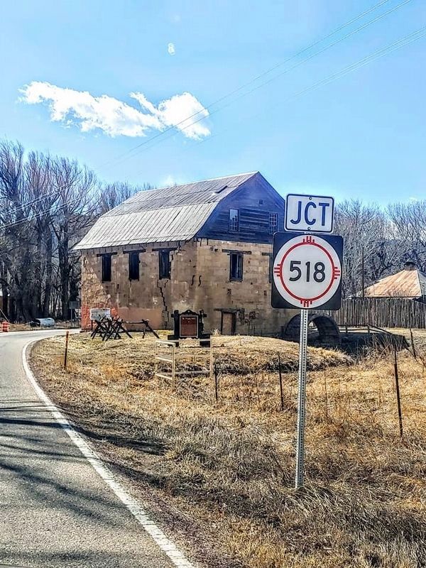
The low line of trees to the south marks La Junta (the junction) of the Mora and Sapello Rivers. It is also known as La Junta because its location is where the Cimarron and Mountain Branches of the Santa Fe Trail join. Arriving with the U.S. . . . — — Map (db m156802) HM
For many of the years between 1851 and 1891, Fort Union was the greatest economic powerhouse in the New Mexico Territory. The single Army officer who controlled the huge complex that made up the Fort Union Depot — some 400 acres of . . . — — Map (db m148810) HM
Just ahead you would have seen a military general store. This was one place at Fort Union where people were always coming and going, every day. Soldiers from the Post, the Depot, and the Arsenal — as well as civilian travelers, Army wives, and . . . — — Map (db m149002) HM
In this early 1860's view, the Commissary Storehouse is hidden behind the shed-like structure on the right. This huge building housed tons of canned and bottled goods, salted meats and fish, as well as onions and potatoes to feed the garrisons of . . . — — Map (db m149005) HM
Imagine 2,000 to 3,000 freight wagons a year being off-loaded into these enormous buildings. In these five warehouses, the United States Army stored, inventoried, organized, and redistributed thousands of tons of food and equipment to support the . . . — — Map (db m149004) HM
The deep ruts etched into the earth in front of you are a record of Fort Union's role as the guardian of the Santa Fe Trail. Formed from a network of routes used for hundreds of years by American Indians, Spaniards, Mexicans, New Mexicans, and . . . — — Map (db m148988) HM
You are looking at the largest United States military base to be found for 500 miles in any direction during the late 1800s. There was nothing bigger from Kansas to California. For 25 years, this frontier-era Army post was a federal government-run . . . — — Map (db m148970) HM
On the indigenous pathway that became the Santa Fe Trail, Native Americans long traveled and traded. After Mexico gained independence from Spain in 1821, the Santa Fe trail developed as an international commercial highway connecting Mexico with the . . . — — Map (db m156800) HM
On the hillside in front of you, the wagon ruts of the Santa Fe Trail bear silent witness to the passage of time and nations moving east and west. When Mexico won its independence from Spain in 1821, legal trade began between the United States and . . . — — Map (db m156801) HM
This square, open yard was once full of men hard at work. The Santa Fe Trail and the rough, unpaved roads of New Mexico Territory in the 1800s were tough on freight wagons — and the livestock that hauled them. Inside this Mechanics' Corral . . . — — Map (db m149007) HM
For westbound travelers, camping here in this green river valley meant that their journey on the Santa Fe Trail was almost over. For travelers headed east it represented a decision, for the trail split here into two very different adventures. The . . . — — Map (db m148818) HM
To us today, Fort Union looks like a single, very large Army base. Soldiers who served here from 1863-1891 saw things in a completely different way. For them, the Post of Fort Union and the Fort Union Quartermaster Depot were like two small towns . . . — — Map (db m149003) HM
Think of what you see here as the forerunner of today's busy truck stops on the interstates. Now, freight rides cross-country safe inside boxes of steel and aluminum, rolling on rubber tires. In the mid-1800s, cargo rode under canvas on iron-shod . . . — — Map (db m149006) HM
The Six Mule Army Wagon contributed to the military's success in the Southwest. With its simple design and iconic red and blue paint scheme, the Six Mule Army Wagon, nicknamed the "Old Army Six Mule", performed the critical role of linking . . . — — Map (db m148980) HM
The Santa Fe Trail was a 900-mile overland road that connected Franklin, Missouri, with Santa Fe, New Mexico. Near here, the trail split into the Mountain Route and the Cimarron Route and travelers had to decide which to take to continue east to . . . — — Map (db m156973) HM
Rested and resupplied at Fort Union, traders headed west into the last 130 miles of the long and arduous trip to Santa Fe. They reached the trading post at Watrous first and then the small town of Las Vegas, founded as a trail stop in 1835. One of . . . — — Map (db m156972) HM
Although taken at different times, these two photos show the Transportation Corral (1) and Herders Corral (2). Dozens of wagons and scores of mules were kept here in readiness to transport supplies and troops. Towering haystacks can be seen in the . . . — — Map (db m149186) HM
Watrous - Western Junction of the Santa Fe Trail has been designated a Registered National Historic Landmark Under the provisions of the Historic Sites Act of August 21, 1935 this site possesses exceptional value in commemorating and . . . — — Map (db m148788) HM
The Motel Safari opened in 1959, during the height of the Mother Road's popularity.
Developer Chester Dohrer employed an architectural style known as 'Doo Wop' or 'Googie' to achieve a unique look that immediately set the Safari apart from the . . . — — Map (db m183590) HM
Born in Bavaria and widowed in Las Vegas, New Mexico, Yetta ran the family store and raised four children alone. She later moved to La Cinta on the Canadian River where she opened another store, became postmistress, started a bank and operated a . . . — — Map (db m78891) HM
In 1829-30, Antonio Armijo traveled from Abiquiú to California to trade for mules, thus extending the Old Spanish Trail and opening it to trade between Santa Fe and Los Angeles. His route turned west, near present-day Abiquiú Dam, to Largo Canyon, . . . — — Map (db m125497) HM
Founded in 1875, this small farming community was named La Jolla. It was once famous for finely woven blankets. Here the Camino Real left the Rio Grande and followed a canyon northeast to Embudo Creek where it began a climb over the mountains to . . . — — Map (db m43810) HM
Harriet was an astute financial manager and the first female bank president in New Mexico, operating the First National Bank in Farmington from 1922 until 1951. During the Depression she bought out San Juan National Bank, keeping it solvent and . . . — — Map (db m59629) HM
Built by M.J. Cavanaugh
for Aniceto Baca.
First housed the O.I. Houghton
Hardware and by 1890 the
Appel Brothers Mercantile.
Saibe Segura's confectionary was
located here following
World War II. — — Map (db m236676) HM
Frank Chapman maintained a granary
and later a billiard parlor in this oldest
structure on Bridge Street. David
Winternitz later added to the building
for his growing general
hardware business. — — Map (db m236696) HM
Built for Andres Dold
Designed by Charles Wheelock
Site of Brownlee, Winters & Co.,
druggists, before being sold to
attorney John De Witt Veeder.
The Dold brothers, Andres & John,
were listed among the top five wealth
holders in New Mexico . . . — — Map (db m236738) HM
Contractor: Charles Stebbins &
Frank Martsoff
Founded by pioneer bankers, the
Raynolds brothers, the First National
Bank expanded to Albuquerque and
El Paso. — — Map (db m236702) HM
Old Town Las Vegas property owners and over 60 private investors created an innovative partnership to rehabilitate 15 buildings in the Plaza, Bridge Street and Distrito de las Escuelas National Historic Districts. La Plaza Vieja Partnership was a . . . — — Map (db m236688) HM
Originally a two-story Victorian
hardware store for Marwede, Brumley &
Co., then restructured by Ludwig Ilfeld
after a 1913 fire, this building later
housed the N.T. and
Fair Department Stores. — — Map (db m236665) HM
Built by the Maloof family on the
site of the W. H. Shupp Carriage
Manufactory, called the “best carriage
works in the Territory,” which
supplied rolling stock throughout
New Mexico and Arizona. The El Rialto
Restaurant was established . . . — — Map (db m236693) HM
Built by Charles Blanchard. Site of Paul Marcellino's Music Hall. Boffo and Perez Marcellino were also fruit dealers on the Plaza. Korte's Furniture has been located here since 1957 — — Map (db m236690) HM
[English side] Near this spot on November 13, 1821, a band of six Missouri traders led by William Becknell, encountered a force of more than 400 Mexican soldiers, militia, and Pueblo Indians under the command of Caption Pedro Ignacio Gallego. . . . — — Map (db m236774) HM
Architects: Issac H. & William M. Rapp
Built by Secundino and Cleofes Romero.
One of the last California Mission
Revival Style buildings built in
Las Vegas. Drug stores have occupied
this corner of the Plaza since the
arrival of the railroad . . . — — Map (db m236700) HM
The Veeder Brothers were attorneys
and community leaders. They
resided on the second floor while
Hofmeister's Grocery occupied
the first floor. This is the only
Panel Brick Style building on the Plaza. — — Map (db m236750) HM
At age nineteen, David Chevalier
Winters ran the Trinidad Enterprise
newspaper before coming to Las Vegas
in 1880 as a druggist. The building was
later a saloon and billiard parlor. — — Map (db m236685) HM
Architects: Issac H. & William M. Rapp
Founded as W.N. Chick & Co. before the
Civil War, the firm became Chick, Browne
& Co. in 1858 and Browne & Manzanares
in 1878. Commission houses served as
ordering agents, transporters and
wholesalers . . . — — Map (db m236597) HM
First Mary J. Woods and later Clara
Waring, were the first to introduce
bookstores to Las Vegas. Later, in the
1930's, Mrs. C. L. M. Bailey also
operated a bookstore in this building. — — Map (db m236638) HM
Architects: Issac H. & William M. Rapp
The firm of Otero & Whiting was founded
by Miguel A. Otero in Kansas in 1861.
This large commission company came to
Las Vegas with the railroad and operated
as Otero, Sellar & Co. until 1879. The
firm . . . — — Map (db m236632) HM
Architect: Henry C. Trost
Contractor: Maurice M. Sundt
Built by a community hotel corporation headed by Louis C. Ilfeld. A fight in the lobby between Judge David J. Leahy and muckraking journalist Carl C. Magee left an innocent bystander dead . . . — — Map (db m236580) HM
Built as a saloon and clubrooms by U.S.
Deputy Marshall N. T. Cordova and J.G.
Montano, it later served as the store
and warehouse for a prominent wool
and hides company. — — Map (db m236646) HM
Originally a two-story building that
housed the Wells Fargo Express
Office as well as retail space.
By 1908 the third story
had been added. The building
is an excellent example of World's
Fair Classic Architecture. — — Map (db m236635) HM
Trinidad Gachupin Medina was the most widely known Zia potter of her time. She was recognized for her large polychrome storage jars. Sponsored by trader Wick Miller, she toured the United States from 1930 to 1946, demonstrating pottery making at . . . — — Map (db m32859) HM
… where you will experience the tri-cultural story of New Mexico, a history of the Indians, the Spanish, and the Anglos each altering this landscape in their efforts to obtain turquoise, lead, silver, and more.
Indians mined nearby . . . — — Map (db m70565) HM
The earliest records, 1893, show the two structures that are today the
Briggs Building as saloons. By the late 1890s they had merged into one
large saloon, but by 1902 the building on the left sold clothes & dry goods
and the one on the right . . . — — Map (db m181829) HM
The earliest records show three saloons packed closely together along First Street here. By 1900 this building housed Louis Darass' saloon, and toward the middle of the block the third building was Joe & Anna Vergolio's bakery and general store. . . . — — Map (db m181584) HM
Cerrillos through the Years First the Indians, then the Spanish and Territorials who passed this way trod this land between Rio Galisteo and the Arroyo San Marcos. But in the end it was the railroad that made the town. It is hard to imagine . . . — — Map (db m181859) HM
J.H. Gerdes' tailor & dry goods store was here, possibly as early as the
mid 1880s, and certainly during the 1890s. For the first three decades of
the 20th century this was Tom DeLallo's building, first as a saloon, but by
1909 as the Cerrillos . . . — — Map (db m181787) HM
The Cerrillos Town Company first sold this lot sometime before
1893, and a general store was built upon it. By 1898 a small house was
situated on the river bank behind this store. For a time around 1902 this
was a carpentry shop, and then by . . . — — Map (db m181785) HM
Charles Lyon of Carbonateville built the first structure on this site some-
time after 1884, and by 1893 he operated a restaurant and the post office
here. In the early 1900s this became Ella Weltmer's stationery & books
and ice cream parlor. . . . — — Map (db m181788) HM
The earliest records for the five lots between Simoni's building and
this corner list various members of the Granito clan, but by 1923 they
were all in the hands of Rafael's son, Joseph M. Granito. At different times
these lots had been . . . — — Map (db m181633) HM
In 1892 Sarah Jones purchased these lots and her husband, L.G. Jones,
built this two-story structure, which housed at various times Benn & Jones
bar, Miller & Legace drugs & novelties, Mrs. Doyle's dry goods, groceries
& notions, a feed store, . . . — — Map (db m181786) HM
Welcome to Cerrillos (Little Hills)
Cerrillos was once seriously considered as the capitol of New Mexico. Cerrillos mining district is one of the oldest and most marked of the old Spanish mineral developments in the Territory. Ttwenty-one . . . — — Map (db m181833) HM
Welcome to Madrid on the Turquoise Trail
The Town of Madrid was founded in 1869 In the 1800’s, when the Santa Fe Railroad arrived in the area, coal mining began on a large scale.
As many as 1,500 years ago, the first Native American . . . — — Map (db m181503) HM
In 1573 King Felipe II of Spain decreed an end to expeditions of conquest.
However, on April 19, 1583 he directed the Viceroy of New Spain to contract
with a responsible citizen to settle New Mexico at his own expense primarily to
see to the . . . — — Map (db m182257) HM
1598-1890
El Camino Real (The Royal Road) sustained New Mexico's settlers from the start.
Settlers traveled north to la tierra adentro (the interior land) and back to cities in
the south. El Camino Real was a viable commercial route for . . . — — Map (db m182314) HM
Santa Fe, now 366 years old, joined the rest of the United States in celebrating the nation’s 200th birthday. New Mexico and the entire Southwest continued to see tremendous expansion and population growth with the influx of migration from the . . . — — Map (db m76316) HM
At first, traders used whatever farm wagons they could find to transport their goods, but as traffic on the trail increased, heavy freight wagons were built specifically for the Santa Fe trade. The industry employed hundreds of skilled woodworkers, . . . — — Map (db m185106) HM
When you cross the bridge over the Santa Fe River, you join a trail with nearly 500 years of New Mexico history! This part of the Santa Fe River Greenway follows one of North America's most famous early roads - El Camino Real de Tierra Adentro, the . . . — — Map (db m185084) HM
First gold placer mining west of the Mississippi began with the discovery of the precious metal in the rugged Ortiz Mountains south of here in 1828, 21 years before the California gold rush. Since then, the district has produced more than 99,000 . . . — — Map (db m45477) HM
For almost 60 years, from 1821 to 1880, the Santa Fe Trail was part of a complex web of international trade and business. The trail began as a connection from the Missouri frontier in the United States to Santa Fe in Mexico. Spanning 900 miles, the . . . — — Map (db m184611) HM
The Old Spanish Trail from Santa Fe to Los Angeles. In the years 1829 to 1848 pack mule trains regularly left the Santa Fe Plaza and northern New Mexico carrying woolen goods produced in New Mexico bound for California. Horses and mules were . . . — — Map (db m64852) HM
The Spiegelbergs arrived in Santa Fe in 1846. A family of merchants and bankers, they quickly became political, cultural, and community leaders, establishing the city's first nonsectarian school, first large general merchandise store, and the Santa . . . — — Map (db m184943) HM
(side one)
Three generations of one family worked more than 100 years to preserve the cultural heritage of New Mexico. Eva Fenyes created an artistic and photographic record of missions and adobe buildings, and preserved Spanish . . . — — Map (db m45481) HM
Santa Fe became a hub of international trade in the 1800s. Materials from European and US manufacturers arrived from the east. Goods from central Mexico and South America arrived from the south. Products were traded at western ports for livestock . . . — — Map (db m184605) HM
Santa Fe's oldest and best known restaurant.
Established in 1944 by Rosalea Murphy. The Pink Adobe is regarded as Santa Fe's own national treasure. The "Pink" is located in the historic Barrio de Analco, one of the oldest areas of Santa Fe and . . . — — Map (db m184949) HM
You are standing on Fort Marcy Hill, a site of human occupation for a thousand years. Pueblo Indians and their ancestors lived here. Between 1600 and 1680, the hill was common land for Santa Fe colonists. The Spanish built a small fort on a hill . . . — — Map (db m184791) HM
Seated clay figurines known as rain gods or "rain catchers" spring from Tesuque Pueblos's deep-rooted figurative pottery tradition. Popularized in the 1880's, Tesuque women made and sold the figurines in a variety of colors and designs, and earned . . . — — Map (db m32853) HM
Hillsboro was founded in the 1870’s after gold and silver was discovered in the surrounding Black Range. The town developed into an important mining and ranching center, and served as the Sierra County seat from 1884 to 1939. It was the site of . . . — — Map (db m38207) HM
Arriving in the silver mining boomtown of Kingston in 1886, Sadie Jane Creech Orchard is arguably the most colorful woman in New Mexico history. Sadie opened brothels, worked as a prostitute, built and operated hotels, restaurants, and co-owned and . . . — — Map (db m97441) HM
Cutting through the southern edge of the Manzano
Mountains, this area has always been an important
trade route. The trail linked Abó and the Salinas
pueblos to the Rio Grande pueblos, fostering trade of
beans, cotton, buffalo meat and salt with . . . — — Map (db m235442) HM
Silver was discovered in Kelly around 1866 and the town site was laid out in circa 1879. Kelly boomed with silver mining and eventually zinc mining, becoming one of central New Mexico's most prosperous mining towns. At one time it boasted a . . . — — Map (db m38862) HM
Kelly prospered in the 1880s after lead and silver discoveries around 1866. But it was the discarded zinc carbonate - vital in paint manufacturing - that made Kelly boom in the early 1900s. Stores, banks, saloons, schools, and churches lined its . . . — — Map (db m238361) HM
South across the road lies one of the west's historic "hoof highways" which was used annually from 1885 until 1971. Sheep and cattle were driven to and from the railroad at Magdalena, NM or to Springerville, AZ. The driveway was 5 to 10 miles wide . . . — — Map (db m60565) HM
This building, erected about 1880, contains one of the oldest, continuously operated drugstores in New Mexico (since 1898).
Site No. 506
A Registered Cultural Property
State of New Mexico — — Map (db m235425) HM
A Registered Cultural Property
Built circa 1870.
Original home of a
prominent territorial New
Mexico merchant and
political figure.
Site No. 153
State of New Mexico — — Map (db m196735) HM
A Registered Cultural Property Hotel La Fonda de Taos 1820 – Site of St. Vrain Mercantile & Inn 1882 – Rebuilt into Columbian Hotel 1937 - Remodeled into existing structure Site no. 860 State of New Mexico — — Map (db m235833) HM
A Registered Cultural Property The Alley Cantina A contributing structure in the Taos Downtown Historic District SR 860 State of New Mexico — — Map (db m236526) HM
These mounds are all that is left of a pueblo that for 300 years was a center for commerce and ceramic production. Indigenous traders from the Great Plains and nearby pueblos came to Abó to barter for pottery, salt, corn, and piñon nuts. . . . — — Map (db m235447) HM
Camino Del Llano (Road to the Plains) played a significant role in the history of Belen and the surrounding communities. While the history of its use extends into colonial New Mexico, it continued to be defined by trade and commerce into the 20th . . . — — Map (db m169529) HM
has been placed on the
National Register of Historic Places
by the United States Department of the Interior
Built in 1879
Through the political influence of the Luna family, the county seat moved from Tome to Los Lunas in 1876. When the . . . — — Map (db m196730) HM
Also known as the Luna-Otero home, it was built for Don Antonio Jose Luna by the Santa Fe Railroad in 1880 in return for a right of way through the family hacienda. Numerous trips through the south inspired the design and style of architecture, . . . — — Map (db m49030) HM
191 entries matched your criteria. Entries 101 through 191 are listed above. ⊲ Previous 100