Near Bay Shore Drive (County Highway B) 0.4 miles north of Bay Shore Heights Drive, on the left when traveling north.
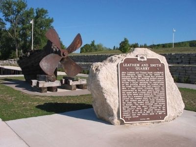
John Leathem and Thomas Smith established this dolomite quarry at the mouth of Sturgeon Bay in 1893. Though they produced dimension stone for building harbors around Lake Michigan, Leathem and Smith's quarry became a major operation by capitalizing . . . — — Map (db m39345) HM
For many centuries, mariners have traversed the Great Lakes to deliver passengers and cargo, to gather fish, and to enjoy the splendid waters. This plaque is dedicated to those who lost their lives in this great water wilderness: the commercial . . . — — Map (db m89853) HM
Bob Peterson lived on the water, worked on the water and played on the water. In 1939 he officially joined Peterson Builders Inc., the shipyard started by his father, Fred. After several military deferments, he enlisted in the army and served as . . . — — Map (db m89858) HM
In the early 1850's Robert Laurie and his family immigrated to the United States from Glasgow, Scotland. They bought land north of the village of Sturgeon Bay in an area now known as Sevastopol. Mr. Laurie, a sailor and shipbuilder by trade, found . . . — — Map (db m89852) HM
Near Canal Road east of Buffalo Ridge Road, on the right when traveling east. Reported missing.
This canal was the dream of Joseph Harris, Sr., "the Father of the Sturgeon Bay and Lake Michigan Ship Canal." His intent was not only to provide a shorter and safer route for sailing vessels, but to also become rich by selling building lots along . . . — — Map (db m15196) HM
Prior to merging with the City of Sturgeon Bay in 1891, the west side of the bay was known as Sawyer. Despite being absorbed into Sturgeon Bay, the west side continued to be called Sawyer for many years and many landmarks bear the Sawyer name, . . . — — Map (db m145896) HM
On U.S. 2 at Ranger Road, on the right when traveling east on U.S. 2.
The Brule River flows in the former channel of a larger river which once flowed in the opposite direction and drained melting ice from glacial lake Duluth. The receding glacier created Lake Superior and also carved the valley now occupied by the . . . — — Map (db m58502) HM
On East 1st Street, 0.2 miles west of 37th Avenue East, on the right when traveling west.
These docks, the largest in the world, consist of three structures of concrete and steel. The longest dock is 2244 feet long, 80 feet high, and contains 374 individual pockets which can hold 100,000 long tons of ore, or 7 average trains of 205 cars . . . — — Map (db m147249) HM
The Great Lakes whaleback fleet was the revolutionary result of Capt. Alexander McDougall's attempts to improve conventional ship design. Between 1888 and 1898, 43 whalebacks were launched and became forerunners of the bulk fleet on the Great Lakes . . . — — Map (db m201029) HM
On East Main Street (State Highway 29), on the right when traveling east.
The bank was incorporated in this building July 3, 1879. It has served the financial needs of the community since that date.
Senator James H. Stout, for whom the University is named, was President from 1906-1910. — — Map (db m88413) HM
On County Highway V, 0.2 miles west of State Highway 27, on the left when traveling west.
Water-powered grist mills ground the wheat that dominated Wisconsin’s Civil War-era economy. Built in 1864, this mill was one of several serving area farmers. After wheat production moved westward, owners adapted the building to mill flour and grind . . . — — Map (db m21228) HM
Officially known as Eau Claire River 2WP224 Dam and dedicated on August 12, 1937, this concrete gravity structure owes its existence to the unemployment crisis of the Great Depression and the need for conservation. The stock market crash of 1929 . . . — — Map (db m231716) HM
When Ojibwa Indians ceded their Chippewa Valley lands to the United States in 1837, Yankee and Canadian lumbermen rushed westward to explore the region's vast white pine forests. At this meeting plasce of two rivers, Eau Claire provided an . . . — — Map (db m74636) HM
Near Randall Street west of Whipple Street, on the left when traveling west.
For 19th century lumbermen, the key to logging in the Chippewa Valley was getting pine logs to go where they wanted them to go. In 1879, the Eau Claire Dells Improvement Company dammed the Chippewa River and created a huge log holding pond, but . . . — — Map (db m74714) HM
On Menomonie Street west of Fifth Avenue, on the left when traveling west.
I am prepared to sell business and residence Lots, Farming or Pine Lands, which I offer upon the most reasonable terms, or receive in exchange labor, oxen, horses, lumber, logs, or personal property of whatever name or nature. Call and see . . . — — Map (db m74866) HM
Near 3rd Avenue south of Water Street, on the left when traveling south.
The 1849 Ojibwe delegation to Washington, D.C. carried this pictograph depicting Ojibwe clans with their eyes and hearts connected to the chain of wild rice lakes south of Lake Superior. Drawing by Seth Eastman from Henry Schoolcraft's . . . — — Map (db m75477) HM
On 3rd Avenue at Lake Street, on the left when traveling south on 3rd Avenue.
Built in 1899, a significant Colonial Revival style designed by architect Cass Gilbert. Charles Ingram was the son of one of Eau Claire's prominent lumbermen, O. H. Ingram. He held a number of positions in his father's Empire Lumber Company.
. . . — — Map (db m43503) HM
Near Menomonie Street south of Carson Park Drive, on the right when traveling east.
"I had no idea there was so much business done here. In just one mill where Charley is at work, they saw one hundred thousand feet a day. It keeps Charley pretty busy. He don't get any time to rest except Sunday."
From the letters . . . — — Map (db m76025) HM
On Jefferson Street at South Dewey Street, on the right when traveling east on Jefferson Street.
Historic Building
Otto and Lina Demmler built this in 1887. Otto, a German immigrant started a floral business in 1885 with his brother Edmund and built six greenhouses for the business, which were located south of the house. Otto died in 1927 . . . — — Map (db m76106) HM
On First Avenue at Grand Avenue, on the left when traveling south on First Avenue.
Eau Claire grew up overnight. Lumbermen rushed to exploit its prime location at the junction of the Chippewa and Eau Claire Rivers. Gilbert Chapman and Joseph Thorpe began sawing timber on the banks of the Eau Claire River in 1857. A few miles away, . . . — — Map (db m43562) HM
On West Grand Avenue east of 4th Avenue, on the left when traveling west.
This Queen Anne style house was built by Eliza Parrant in 1881. Several houses in the vicinity replicate many stylistic features of this house, which was sold to Thomas McDermott in 1899. McDermott was a timber scout for the Badger State Lumber . . . — — Map (db m43502) HM
Near First Avenue at Hudson Street, on the left when traveling south.
"Immigrants are pouring in...land I would never have thought of choosing is being taken up." Writing from Chippewa County's Clear Water post office in 1855, Thomas Barland could scarcely have imagined the tide of immigrants yet to land in Eau . . . — — Map (db m43563) HM
Near 9th Avenue at Broadway Street, on the left when traveling north.
Half Moon Lake has been used as an industrial site since 1850 when white settlement began in Eau Claire. The lake's crescent shape and drainage formed a natural holding pond for logs and between 1867 and 1884 seven logging companies located along . . . — — Map (db m75203) HM
On Second Avenue at Hudson Street, on the right when traveling south on Second Avenue.
Historic Building
This house was designed by the architectural firm of Purcell and Feick from Minneapolis. Built in 1909 by Mr. and Mrs. J. D. R. Steven, it is a fine example of Prairie School architecture. Mr. Steven was part owner of the Eau . . . — — Map (db m43506) HM
On Menomonie Street at Tenth Avenue, on the right when traveling east on Menomonie Street.
Historic Building
This building which was built in 1905 is the former office of the Kaiser Lumber Company. It is one of the few remaining buildings from Eau Claire's great lumber industry which got its start in the 1860's. Kaiser Lumber Company . . . — — Map (db m74613) HM
The legend of Paul Bunyan is the creation of lumberjacks from Canada to the United States and from Maine to the Pacific Northwest. It probably had its roots in a real person. There was a soldier, named Paul Bunyan, who fought with Papineau in the . . . — — Map (db m57620) HM
On First Street north of Bolles Street, on the right when traveling north.
Nineteenth century lumbermen made numerous improvements on the Chippewa River to ease the task of transporting logs and lumber. Such improvements required legislative approval, so lumbermen commonly lobbied Madison legislators or themselves . . . — — Map (db m75599) HM
On Lake Street at 3rd Avenue, on the right when traveling west on Lake Street.
Built in 1897, the Clark house is a combination of Colonial Revival and Neo Classical architecture. Nancy Clark was the widow of dewitt Clark, a banking partner of lumberman O. H. Ingram.
Designated District November Seventeen
Nineteen . . . — — Map (db m43499) HM
Near Lake Street at West Grand Avenue, on the left when traveling west.
"The regular meeting of the Dovre Ski Club will be held Friday evening...all members must be present. The home boys have improved wonderfully and a lively contest is looked for."
Eau Claire Weekly Free Press . . . — — Map (db m75466) HM
Looking east across Half Moon Lake from the northeast corner of Carson Park one sees the swimming beach and bath house. These structures are adjacent to the terminal point of a former engineering feat known then as the log flume. Essentially this . . . — — Map (db m46590) HM
Near Carson Park Drive, 0.1 miles west of West Grand Avenue, on the right when traveling west.
Sawdust and Ice Harvest
Each winter 350 lb. cakes of ice were cut from Half Moon Lake. After the harvest crews conveyed them to ice houses on shore, they were packed in 18 inches of the plentiful sawdust from local sawmills. Stored that . . . — — Map (db m46570) HM
The Chippewa River acted like a natural highway in the late 1800s transporting logs downstream to the sawmills while providing transportation for loggers and business people alike. From this very location, one would see numerous steamboats . . . — — Map (db m74916) HM
On West Grand Avenue at 3rd Avenue, on the left when traveling west on West Grand Avenue.
Thomas McDermott, a local lumberman, built this Queen Anne style house in 1887. McDermott served in the Sixth Minnesota volunteer infantry in the early 1860s. After serving in the military, he worked as an explorer and scout for the lumber industry . . . — — Map (db m43500) HM
As a frontier town, Eau Claire relied on the river to transport people and products. The Water Street Business District grew up convenient to the steamboat landing, where twice weekly the "Jennie Whipple" unloaded passengers opposite the . . . — — Map (db m74588) HM
Near North Madison Street (County Highway M) 0.4 miles north of East Main Street (State Highway 49), on the left when traveling north.
Inventor of the Hot-Patch, is fondly remembered by the residents of Waupun for: creating the Shaler Scholarships; being instrumental in the formation of the Rock River Country Club; purchasing for the city the world famous End of the Trail by Fraser . . . — — Map (db m25637) HM
Near Elm Street (U.S. 61) 0.3 miles south of State Highway 60, on the left when traveling north.
Towns like Boscobel developed along the Lower Wisconsin River as a result of the confluence of transportation networks.
[map of stagecoach routes between Lake Michigan and the Mississippi River]
In the 1830s and 1840s, . . . — — Map (db m47936) HM
Near Elm Street (U.S. 61) 0.3 miles south of State Highway 60, on the left when traveling north.
About 11,000 years ago, Native people moved into what is now Wisconsin. In the Chippewa [Ojibwe] language, Wisconsin means "gathering of the waters."
The Native American found a land of many possibilities. Animals such as mammoth, . . . — — Map (db m46772) HM
Near South Main Street (State Road 80) south of West Webster Street, on the right when traveling south.
The baggage cart was a standard item on all railroad depot platforms. Their platform was the approximate height of the rail car's bed. This made loading and unloading the baggage and freight fast and easy. Note the handle, this was only pulled . . . — — Map (db m162588) HM
Near South Main Street (State Road 80) south of West Webster Street, on the right when traveling south.
In areas where there were few cheese factories or creameries, the farmer depended on the railroad to deliver the milk. Platforms the height of the car deck were built next to the tracks. In the evening the farmers of the area would deliver their . . . — — Map (db m162590) HM
On West Main Street (County Road B) 0.1 miles west of North Elm Street, on the right when traveling west.
Willard was 26 when he volunteered to join the Lewis & Clark expedition. He served primarily as a blacksmith and hunter and knew some carpentry and gun repair; all skills called upon during the Corps of Discovery's journey. Alexander, wife . . . — — Map (db m237900) HM
On W. Irving Place at Court Street, on the left when traveling east on W. Irving Place.
Settled in response to the discovery of lead ore in the area, the original Village of Platteville was platted in 1835. Designed around existing miners' diggings, and lead ore smelters, Platteville was patterned after English villages with narrow . . . — — Map (db m33132) HM
On E. Pine St. at Lilly St., on the right on E. Pine St..
(from the memoirs of John H. Rountree): "During the fall of 1827 my partner and myself purchased a mineral prospect that had been discovered, by finding small pieces of lead mineral in the litter piles of dirt scratched out by the badger to make . . . — — Map (db m33280) HM
One of Wisconsin's earliest mining communities, Potosi was settled in 1829 after lead ore was found near St. John Mine. Named for the silver mining town of "Potosi" in Bolivia, South America, the village began as three separate settlements and . . . — — Map (db m119347) HM
On State Highway 69 at Lake Road (County Highway F), on the left when traveling south on State Highway 69.
Born in 1836 in Canton Berne, Switzerland, where he learned cheese making, Nickolaus Gerber immigrated to New York and founded that state's first Limburger cheese factory. After hearing reports of successful dairy cattle-raising in Green County, . . . — — Map (db m35473) HM
On Railroad Street at 5th Avenue, on the right when traveling north on Railroad Street.
In 1845 the Emigration Society of the Canton of Glarus, Switzerland, sent Nicholas Duerst and Fridolin Streiff to the United States to purchase land for a Swiss settlement. They were joined in August by 108 settlers who began their homesteads on . . . — — Map (db m5052) HM
On North Second Street at West Main Street (Wisconsin Highway 73), on the right when traveling north on North Second Street.
Princeton's Cattle Fair, a monthly market, held on the first Wednesday of each month for over 100 years in this area, emerged from early county fairs beginning in 1856.
Erected 1973 — — Map (db m36439) HM
On County Road Y, 0.1 miles east of Governor Dodge Road, on the right when traveling east.
Arriving in Dodgeville in 1827, Henry Dodge, later renowned as a Black Hawk War military leader, territorial governor and state senator, began his Wisconsin career as a miner. In circa 1830, Dodge established living quarters and a large two-furnace . . . — — Map (db m32450) HM
On Ridge Street (State Highway 39) at Madison Street, on the left when traveling south on Ridge Street.
In the 1820s, after hearing reports of abundant lead in the area, prospective miners with "lead fever" began pouring into southwestern Wisconsin. Finding ore just beneath the surface, miners set up "diggings" and soon established Mineral Point. It . . . — — Map (db m35335) HM
On U.S. 14, 0.2 miles east of Helena Road, on the right when traveling east.
Frank Lloyd Wright, Wisconsin-born, world-renowned architect, lived and worked in Wyoming Valley, 6 miles southwest of here, at Taliesin, his home and school for apprentices. In the practice of "organic" or natural architecture, he sought to blend . . . — — Map (db m19276) HM
Near County Highway C, 2 miles west of U.S. 14, on the right when traveling west.
Twenty years before Wisconsin became a state, the discovery of vast lead deposits brought a population boom to this area.
Green Bay merchant Daniel Whitney organized the Wisconsin Shot Company to build a shot tower on this site. T.B. Shaunce . . . — — Map (db m35334) HM
The Gogebic Iron Range, which may be seen to the south of here, extends 80 miles from Lake Namekagon, Wisconsin to Lake Gogebic (Chippewa for “place of diving”) in Michigan. Prior to the discovery of iron ore the area was relatively uninhabited as . . . — — Map (db m210258) HM
Near U.S. 51 south of West Groveland Drive (U.S. 2), on the right when traveling south.
Although iron mining in Wisconsin had its beginnings in Sauk, Dodge and Jackson counties in the southern part of the state in the 1850’s, discoveries of vast new deposits shifted the focus to northern Wisconsin in 1880. The major iron mining area . . . — — Map (db m30849) HM
This 5 ½ foot diameter drill core came from the Cary Mine shaft from a depth of 2400 feet below the surface. The shaft was drilled during the period 1942-44 from surface to the 31st level and was later enlarged to its full size of 13X21 feet. . . . — — Map (db m36838) HM
On Manitowish Road at U.S. 51, on the right when traveling north on Manitowish Road.
Main streets developed at the cross roads of resources, transportation, and people. The town of Manitowish grew up on timber and the railroad.
By the turn of the century, the “inexhaustible” stands of white pine had been cut from . . . — — Map (db m45527) HM
On County Route FF, 0.5 miles north of Turtle Flambeau Dam Road, on the right when traveling north.
America saw the vast forests of the Great lakes as an endless supply of the timber needed to settle the west. Farmers, factories and mills needed wood for fuel and building materials.
Men came to the northern forests to make their fortunes . . . — — Map (db m59479) HM
The felling of Iron County’s great stands of timber began in the late 1870’s. The white pine was the first to be cut. Down the Turtle River and over Lake of the Falls, buoyant pine logs were floated to sawmills further south.
Spring, when the . . . — — Map (db m46688) HM
On County Route FF, 0.5 miles north of Turtle Flambeau Dam Road, on the right when traveling north.
The railroad pushed into northern Wisconsin in the 1870s, opening the deep forests for harvest. Now hardwoods such as maple, oak, spruce, cedar, balsam, birch and aspen could be cut.
More logs could be shipped by rail than by water so more men . . . — — Map (db m59480) HM
On County Route FF, 0.5 miles north of Turtle Flambeau Dam Road, on the right when traveling north.
This camp was Carl Nelson’s headquarters camp. From this camp, he directed the woods operations and sent rail cars of timber south to the main line at Camp 8.
While all of the buildings are gone, artifacts found at the site tell a story of what . . . — — Map (db m59481) HM
On County Route FF, 0.5 miles north of Turtle Flambeau Dam Road, on the right when traveling north.
Large, heavy cable remains from the pulley system (called a jammer), used to load the logs from the landing into the rail cars. Stove parts, railroad ties, a wash tub and glass bottles suggest a long term camp with railroad connections. . . . — — Map (db m59482) HM
On County Route FF, 0.5 miles north of Turtle Flambeau Dam Road, on the right when traveling north.
William Henry Roddis realized that a fortune could be made in the woods.
In 1903, he purchased a parcel of land to build a mill in Park Falls. Roddis bought 35,000 acres of timber land in Iron and Ashland counties from Wisconsin Central . . . — — Map (db m59477) HM
On County Route FF, 0.5 miles north of Turtle Flambeau Dam Poad, on the right when traveling north.
In 1925, the Roddis company contracted with Carl Nelson, a jobber, to run the camps. Between 1925 and 1930, he chose the camp sites, bought supplies and delivered timber to the log landings.
From 1930 until the company abandoned logging in . . . — — Map (db m59478) HM
On Turtle Flambeau Dam Road, 0.5 miles east of County Route FF, on the left when traveling east.
In 1925, the Chippewa and Flambeau Improvement Company began construction on a dam to create a water reservoir for hydroelectric power, where the Turtle, Manitowish, and Flambeau rivers join.
The Roddis company owned land in the area, which . . . — — Map (db m59476) HM
On Wisconsin Route 77, on the right when traveling east. Reported missing.
1884 … The rush was on to discover “red gold” on the Penokee Range! Speculators, miners and immigrants flocked to this area seeking their fortune in iron ore. Established as a small open pit mine in 1885 by the Oglebay-Norton Mining . . . — — Map (db m45158) HM
On Montreal Street at Wisconsin Avenue (Wisconsin Highway 77), on the left when traveling south on Montreal Street.
Neat white frame houses, gently curving streets, and gracious landscaping mark the City of Montreal – the only planned mining company town in Wisconsin.
In 1921 the Oglebay-Norton Mining Company designed a community that would provide an . . . — — Map (db m45408) HM
On Kokogan Street at Mellen Street, on the right when traveling south on Kokogan Street.
Mining Upside Down
The large tailing piles across the river from Gile Falls are waste rock left from its mining at the Montreal Mine #5 Shaft.
The Montreal Mine’s vertical shaft extended to the depth of nearly one mile underground. Like . . . — — Map (db m46689) HM
On Montreal Street at Wisconsin Ave (Wisconsin Highway 77) when traveling south on Montreal Street.
You are standing in the architectural complex that supported iron mining at the Montreal Mine #5 Shaft – the heart of the mining community known as “Montreal Location.”
The huge native field stone building served as the . . . — — Map (db m45411) HM
On Wisconsin Avenue (State Highway 77) at Plant Street, on the right when traveling west on Wisconsin Avenue.
The City of Montreal, incorporated in 1924, known for a short time as the Village of Hamilton, is a combination of the communities of Montreal and Gile.
Gile, on the river, was the center of the area’s timber industries. The largest, the . . . — — Map (db m40932) HM
Near Plummer Road, 0.2 miles south of Wisconsin Highway 77.
Along this trail are the “ruins” of the buildings that made up the Plummer Mine Location. Each structure had a special function.
Steam power, created at the boiler House, turned the Hoisting Engine. In the early 1920’s, electricity . . . — — Map (db m45417) HM
Near Plummer Road, 0.2 miles south of Wisconsin Highway 77.
Plummer Mine Headframe Interpretive Park
Dedicated to the iron miners and their families who helped build the Penokee Iron Range — — Map (db m45418) HM
Near Plummer Road, 0.2 miles south of Wisconsin Highway 77.
Between 1 to 1 1/2 million years ago sediments of slate and cherty iron carbonates were laid down on top of the granite and greenstone bedrock covering this area. Molten lava flowed over the land, seeping into the great cracks on the surface . . . — — Map (db m45414) HM
On U.S. 2 at Cemetery Road, on the left when traveling east on U.S. 2.
Apostle Islands Scenic View
You are looking out over the Chequamegon Bay region and Apostle Islands which comprises 22 Islands that form an archipelago about 30 miles long and 18 miles wide.
All except one of the Islands (Long Island) are . . . — — Map (db m125029) HM
On State Highway 182, 7 miles west of State Highway 47-182, on the right when traveling east.
"An old Indian legend says that Bearskull Lake is sacred. Any white man who had anything to do with the lake or its vicinity will have everlasting ill fortune."
In 1904, a tornado ripped through this area, toppling the last great stands . . . — — Map (db m59484) HM
On South 3rd Street at Main Street (Wisconsin Highway 54), on the left when traveling south on South 3rd Street. Reported missing.
J-Land Farms – 2004. Albert purchased farm in 1901. Arnold sold to Junior – 1967. Today, Jerry operates the dairy farm & hopes someday, his son Jamey will carry on the "family tradition." J-Land Farms is in the Township of "Garden Valley" in Jackson . . . — — Map (db m80354) HM
Near Interstate 94 at milepost 121, on the right when traveling west.
White pine trees were growing here when Columbus made his voyage to America. In 1819 the first attempts to saw lumber were unsuccessful, but in 1839 Jacob Spaulding founded Black River Falls by erecting the first permanent sawmill and settlement on . . . — — Map (db m3322) HM
On East Main Street (State Highway 54) west of South Roosevelt Road (U.S. 12), on the left when traveling west.
Hagen's A&W Root Beer Stand was a family-owned business for 35 years. The root beer stand was a source of summer employment for area high school students and community members. The A&W was a popular meeting place for local teens. All six of . . . — — Map (db m80390) HM
On North Water Street (U.S. 12) north of Main Street (State Highway 54), on the left when traveling north.
In the early 1900's Peter J. Hoffman organized a dray line & road construction business. Horse & mule teams pulled
wagons & slip dirt scrapes. His wife Anna collected the bills. The construction company had 10 employees.
. . . — — Map (db m80456) HM
On North Water Street (U.S. 12) north of Main Street (State Highway 54), on the right when traveling north.
In
the late 1920's Sam Swensen, uncle of Cliff Nelson & Milt Lunda, started
the
construction co. in Mt. Horeb, WI. It was relocated in 1938 to its present location in Brockway, WI. In the mid 1940's the company was named Nelson . . . — — Map (db m80453) HM
On Main Street (State Highway 54) west of Water Street (U.S. 12), on the right when traveling west.
In 1880, 20 year old Peter L. Moe came to work at Jones & Murray Hardware & eventually gained
ownership in 1896 – renaming it P.L. Moe & Co.. Pete &
Anna raised six sons. Rollin "Junk" and Alvin "Beaner" became owners in . . . — — Map (db m80447) HM
On South 2nd Street at Main Street (Wisconsin Highway 54), on the left when traveling south on South 2nd Street.
The first white man to farm this land was Robert Douglas in 1839. Known as the Webb Farm for 60 years. The Plaffs purchased in 1962, and their children Tom A. and Sarah Pfaff-Clements & six grandchildren continue to make it a family farm with . . . — — Map (db m80325) HM
On Interstate 94 at milepost 124, on the right when traveling east.
Marshy sections of Jackson, Monroe, Wood and Clark counties produce large quantities of Sphagnum moss, providing a major but little known state resource. The ability of Sphagnum to hold 20 times its weight in water makes it invaluable for keeping . . . — — Map (db m49765) HM
On McKenna Road, 3.1 miles south of State Highway 54, on the left when traveling south.
This area was not always as peaceful as it is now. The Jackson County Historical Society has accurately located the former sites of more than forty saw mills in this county. Six hundred people lived around the Goodyear saw mill which was located . . . — — Map (db m176397) HM
On County Highway Q at County Highway B, on the left when traveling south on County Highway Q.
Pioneer Aztalan was settled in 1836 by Thomas Brayton and others at the junction of the Milwaukee-Mineral Point and Janesville-Fond du Lac territorial roads. By 1837 Aztalan had Jefferson County's first post office and by 1842 was its leading . . . — — Map (db m37023) HM
Near Park Road, 0.1 miles north of U.S. 12, on the right when traveling north.
As a boy Ole Evinrude (1877-1934) lived near Cambridge. His father hoped to keep him on the farm and when Ole built a sailboat like he had seen in a picture book his father destroyed it. In a secret place in the woods the boy built another. Here on . . . — — Map (db m35297) HM
Near Gordon Street west of Center Street (State Route 33), on the left when traveling west.
Explored by white lumber prospectors in 1842, this site was settled in 1851 and platted as the Village of Wonewoc in 1854. Long the center of a thriving agricultural district with a vibrant local market, the village was originally a lusty lumber . . . — — Map (db m158700) HM
On 56th Street at 24th Avenue, on the left when traveling west on 56th Street.
Thomas B. Jeffery purchased the 1895 Sterling Bicycle Factory and pioneered Kenosha’s auto industry in 1900. His company was an industry leader, creating the second mass produced auto in 1902. Jeffery was the first auto manufacturer to make all . . . — — Map (db m38570) HM
On Lake Street (State Highway 42) at Ohio Street, on the left when traveling south on Lake Street.
After the disastrous fires that swept through Kewaunee County in 1871, a more substantial building material was sought and brickyards made their appearance in several locations in the county.
A good supply of clay located in the area between . . . — — Map (db m17490) HM
On Willow Drive, 0.1 miles north of Fremont Road, on the left when traveling west.
Henry Bruemmer, a native of Mecklenburg, Germany, learned the milling trade in his native land before emigrating. After spending a few years on the East Coast, he invested in a flourmill in Mishicot before operating a mill at Tisch Mills. In . . . — — Map (db m77474) HM
52 Schooners transporting Christmas trees to Milwaukee and Chicago passed this point in the 1800's.
Captain Herman Schuenemann of the Christmas Tree Ship, "Rouse Simmons", was born in Algoma.
One of the 52 schooners, "Lady Ellen" is located . . . — — Map (db m38986) HM
Near Perry Street (County Highway S) at Buchanan Street, on the right when traveling west.
Just south of this site, brothers Abraham and Simon Hall built the area's first saw mill in 1852. From that time to the present, Algoma has been a significant source of wood products. Ahnapee Seating and Veneer Company was founded on this site in . . . — — Map (db m77326) HM
On County Highway S, 0.2 miles west of Maple Road (County Highway C), on the left when traveling west.
Because permission to emigrate from their home in Euren, Germany, had repeatedly been denied, the family of Michael Bottkol fled to France in the spring of 1856.
Arriving in Kewaunee that summer, the family spent their remaining . . . — — Map (db m77419) HM
Near County Highway S east of County Highway DK, on the left when traveling east.
The first European inhabitant of this area was Louis Van Dycke, from whom the community received its name. Dyckesville, an early Belgian settlement, was a typical crossroads community including a store, church and saloon. It became part of one of . . . — — Map (db m77298) HM
On County Highway F at Dikeman Lane, on the left when traveling west on County Highway F.
The year was 1863. This area was a wilderness accessible only by primitive trails that wound through the vast, virgin pine forest. Here, surrounded by thousands of acres of prime timberland, Charles W. Dikeman and his partners built their . . . — — Map (db m77392) HM
Near Harrison Street at Main Street, on the left when traveling east.
The bluffs overlooking the Kewaunee River north of the city witnessed much of Kewaunee's early history. It was here that Potawatomies had a village and eventually fought a bloody battle with the Sacs, killing an entire band.
Here . . . — — Map (db m77283) HM
Near County Highway F south of County Highway C, on the left when traveling west.
Before modern cement came onto the market, lime was used in the making of mortar for brick and stonework. Lime was also used for whitewashing wood instead of painting. Large furnaces used heat to reduce nearby limestone rocks into lime.
. . . — — Map (db m77521) HM
Near Ransom Moore Lane, 0.4 miles north of County Highway F, on the right when traveling north.
As you look across the Kewaunee River, it is hard to imagine that a small, thriving community existed on the opposite bank. The center of the community was the imposing flour and gristmill, which drew so many customers from miles around that . . . — — Map (db m77523) HM
On Main Street (County Highway AB) north of Elm Street, on the right when traveling north.
Bank of Luxemburg was founded in 1902 by a group of
prominent farmers and busnessmen. In 1903 a state
charter was granted and the bank formally began
operations in what was known as the Wisconsin House.
On June 20, 1904, the bank proceeded to . . . — — Map (db m74985) HM
On County Route G at Norman Road, on the right when traveling west on County Route G.
The focal point of any crossroads community in this area include a church, a saloon, a
general store and a cheese factory where milk was turned into a marketable product.
Norman, a Czech heritage community founded in the 1850's was no exception. . . . — — Map (db m39475) HM
On Mill Lane at County Highway BB, on the right when traveling north on Mill Lane.
As the available land to the south became more difficult to obtain, new arrivals began to gravitate northward. In this valley through which flows the East Twin River, many found what they were looking for. This area had been known to the . . . — — Map (db m77602) HM
564 entries matched your criteria. Entries 201 through 300 are listed above. ⊲ Previous 100 — Next 100 ⊳