After filtering for Idaho, 95 entries match your criteria.
Natural Features Topic
By Rebecca Maxwell, March 12, 2012
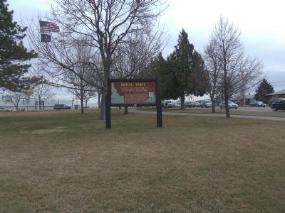
Initial Point Marker at Storey Park
| 1 ► Idaho, Ada County, Meridian — 193 — Initial Point — |
| 2 ► Idaho, Bannock County, Downey — 171 — Red Rock Pass — |
| 3 ► Idaho, Bannock County, Lava Hot Springs — 13 — Lava Hot Springs — |
| 4 ► Idaho, Bannock County, Lava Hot Springs — Lava Hot Springs' healing waters — |
| 5 ► Idaho, Bingham County, Blackfoot — 436 — Big Butte — |
| 6 ► Idaho, Bingham County, Blackfoot — 287 — Lava Formations — |
| 7 ► Idaho, Bingham County, Blackfoot — 428 — Three Buttes — |
| 8 ► Idaho, Blaine County, Bellevue — Timmerman Junction Oregon Trail Kiosk — |
| 9 ► Idaho, Blaine County, Ketchum — 292 — Salmon River — |
| 10 ► Idaho, Boundary County, Bonners Ferry — 321 — Glacial Lakes — |
| 11 ► Idaho, Boundary County, Bonners Ferry — Moyie River Canyon — |
| 12 ► Idaho, Butte County, Arco — A Plain of Volcanoes — |
| 13 ► Idaho, Butte County, Arco — Are We Loving Them to Death? — |
| 14 ► Idaho, Butte County, Arco — Big Cinder Butte — |
| 15 ► Idaho, Butte County, Arco — Boy Scout Cave — Craters of the Moon National Monument and Preserve — |
| 16 ► Idaho, Butte County, Arco — Goodale's Cutoff — |
| 17 ► Idaho, Butte County, Arco — Indian Tunnel — Craters of the Moon National Monument and Preserve — |
| 18 ► Idaho, Butte County, Arco — Just Down the Road — Craters of the Moon National Monument — |
| 19 ► Idaho, Butte County, Arco — Silent Cone — |
| 20 ► Idaho, Butte County, Arco — Vanishing Landmark — |
| 21 ► Idaho, Butte County, Arco — Volcanoes Along the Rift — |
| 22 ► Idaho, Butte County, Arco — Where's the Volcano? — |
| 23 ► Idaho, Butte County, Howe — 227 — John Day’s River — |
| 24 ► Idaho, Caribou County, Grace — Black Canyon Gorge — |
| 25 ► Idaho, Caribou County, Grace — Lava Flows and Wagon Trains — |
| 26 ► Idaho, Caribou County, Soda Springs — "It Roars Like a Mad Dragon" — S.E. Matthews, Soda Springs Geyer Corporation, December 1937 — |
| 27 ► Idaho, Caribou County, Soda Springs — 220 — Bear River Lava — |
| 28 ► Idaho, Caribou County, Soda Springs — China Hat Geological Site — |
| 29 ► Idaho, Caribou County, Soda Springs — Coach History — |
| 30 ► Idaho, Caribou County, Soda Springs — Guiding Landmark... — Sheep Rock — |
| 31 ► Idaho, Caribou County, Soda Springs — 385 — Hooper Spring — |
| 32 ► Idaho, Caribou County, Soda Springs — Sheep Rock Geology — |
| 33 ► Idaho, Caribou County, Soda Springs — 158 — Soda Springs — |
| 34 ► Idaho, Caribou County, Soda Springs — Travertine Terraces - World Famous Water — |
| 35 ► Idaho, Caribou County, Wayan — 433 — Cariboo Mountain — |
| 36 ► Idaho, Cassia County, Almo — Distant Views — |
| 37 ► Idaho, Cassia County, Almo — Twin Sisters — |
| 38 ► Idaho, Cassia County, Oakley — 344 — City of Rocks — |
| 39 ► Idaho, Cassia County, Oakley — Granite Pass — |
| 40 ► Idaho, Clark County, Dubois — Fort Henry Historic Byway — Battle of Camas Meadows — |
| 41 ► Idaho, Clearwater County, Weippe — Weippe Prairie — |
| 42 ► Idaho, Clearwater County, Weippe — Weippe Prairie — |
| 43 ► Idaho, Custer County, Mackay — Earthquake! - The Event — |
| 44 ► Idaho, Custer County, Mackay — Earthquake! - The Results — |
| 45 ► Idaho, Custer County, Mackay — Earthquake! - The Stage — |
| 46 ► Idaho, Custer County, Mackay — 356 — Earthquakes — |
| 47 ► Idaho, Custer County, Mackay — 229 — Goodin's River — |
| 48 ► Idaho, Custer County, Mackay — 45 — Mount Borah — |
| 49 ► Idaho, Custer County, Stanley — The Boiling Fountain — |
| 50 ► Idaho, Elmore County, Mountain Home — 4 — Site 4 ★ Hot Springs — Main Oregon Trail Back County Byway — |
| 51 ► Idaho, Franklin County, Preston — 432 — Old Delta Sediments — |
| 52 ► Idaho, Franklin County, Weston — 553 — Pass of the Standing Rock — |
| 53 ► Idaho, Fremont County, Ashton — Teton Mountain Range — Les Trois Teton or , The Three Breasts — |
| 54 ► Idaho, Fremont County, Ashton — 396 — Volcanic Calderas — |
| 55 ► Idaho, Gooding County, Bliss — Formation of Malad Gorge — |
| 56 ► Idaho, Gooding County, Bliss — 300 — Fossil Beds — |
| 57 ► Idaho, Gooding County, Bliss — The Malad Springs — One of the Largest in the Country — |
| 58 ► Idaho, Gooding County, Bliss — Woody's Cove / The Hagerman Valley — |
| 59 ► Idaho, Gooding County, Hagerman — A Changing Climate — |
| 60 ► Idaho, Gooding County, Hagerman — Ancient Lakes — |
| 61 ► Idaho, Gooding County, Hagerman — Sediments and Fossils — |
| 62 ► Idaho, Gooding County, Hagerman — Volcanoes Along the Snake — Lava Landscape — |
| 63 ► Idaho, Idaho County, Grangeville — The Camas Connection — |
| 64 ► Idaho, Idaho County, Kooskia — The Lolo Trail — "I belong to the land from which I came." Toohoolhoolzote — |
| 65 ► Idaho, Idaho County, Riggins — From The Beginning — Riggins’ Geologic History, Flora and Fauna — Salmon River Heritage Waking Tour — |
| 66 ► Idaho, Idaho County, White Bird — 298 — Salmon River — |
| 67 ► Idaho, Jerome County, Twin Falls — 326 — Emigrant Road — |
| 68 ► Idaho, Kootenai County, Coeur d'Alene — 170 — Coeur d'Alene Lake — |
| 69 ► Idaho, Kootenai County, Harrison — 281 — Submerged Valley — |
| 70 ► Idaho, Kootenai County, Hauser — 256 — Purcell Trench — |
| 71 ► Idaho, Lemhi County, Carmen — William Clark's "Pirimids" — |
| 72 ► Idaho, Lemhi County, Tendoy — "Immence Ranges of High Mountains Still to the West of Us..." — - Meriwether Lewis, August 12, 1805 — |
| 73 ► Idaho, Lemhi County, Tendoy — Agency Creek — Looking West to the Salmon River Country — |
| 74 ► Idaho, Lemhi County, Tendoy — Crossing the Great Divide — Corps of Discovery — |
| 75 ► Idaho, Lemhi County, Tendoy — The Withington Caldera — Lewis and Clark in Lemhi County — |
| 76 ► Idaho, Lewis County, Nezperce — 372 — Camas Prairie — |
| 77 ► Idaho, Madison County, Rexburg — 301 — Menan Buttes — |
| 78 ► Idaho, Madison County, Rexburg — 267 — The Three Tetons — |
| 79 ► Idaho, Nez Perce County, Lapwai — Ant & Yellowjacket — támsoy ka・?alatálo — |
| 80 ► Idaho, Nez Perce County, Lapwai — Clearwater River — kú・s kayxkáyx — |
| 81 ► Idaho, Oneida County, Holbrook — Twin Springs Historic Site — Curlew National Grassland — |
| 82 ► Idaho, Oneida County, Keogh — 317 — Lake Bonneville — |
| 83 ► Idaho, Owyhee County, Marsing — 192 — Owyhee Country — |
| 84 ► Idaho, Payette County, Fruitland — 263 — Snake River — |
| 85 ► Idaho, Power County, American Falls — Coldwater Hill Rest Area Oregon Trail Kiosk — The Oregon Trail — |
| 86 ► Idaho, Power County, American Falls — Snake River Rest Area Oregon Trail Kiosk — The Oregon Trail — |
| 87 ► Idaho, Teton County, Tetonia — 315 — Teton Range — |
| 88 ► Idaho, Twin Falls County, Hagerman — 330 — Fishing Falls — |
| 89 ► Idaho, Twin Falls County, Hagerman — 204 — Salmon Falls — |
| 90 ► Idaho, Twin Falls County, Hagerman — 166 — Thousand Springs — |
| 91 ► Idaho, Twin Falls County, Hansen — Ancient Lake Bonneville — "Southern Idaho's Largest Flood in World History" — |
| 92 ► Idaho, Twin Falls County, Kimberly — History Through the Eyes of a Camera — |
| 93 ► Idaho, Twin Falls County, Murtaugh — 284 — Caldron Linn — |
| 94 ► Idaho, Twin Falls County, Twin Falls — Shoshone Falls — |
| 95 ► Idaho, Twin Falls County, Twin Falls — 172 — Shoshone Falls — |