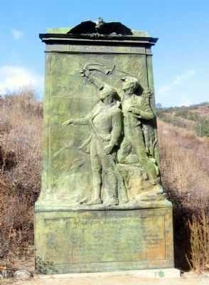
The Army sent from Santa Fe to occupy California was met and defeated by the Mexicans at San Pasquale. The American forces were driven upon a butte in the desert, on which there was no water and there surrounded by the Mexican forces Edward F. Beale . . . — — Map (db m12865) HM
On San Pasqual Valley Road (California Route 78), on the right when traveling west.
The State of California
honors with this monument
the American Soldiers
who, under the leadership of
Brig.-Gen. Stephen W. Kearny,
Captain Abraham R. Johnston,
Captain Benjamin D. Moore,
Edward F. Beale, U.S.N.,
and
Kit Carson, the . . . — — Map (db m51980) HM
On San Pasqual Valley Road (California Route 78 at milepost 25.1), on the right when traveling west.
While marching to the conquest and occupation of California during the Mexican War, a detachment of 1st U.S. Dragoons, under the command of Brig. Gen. Stephen W. Kearny, was met on this site by native California lancers under, the command of Gen. . . . — — Map (db m51095) HM
Near Mason Street north of San Diego Avenue, on the left when traveling north.
On this site the United States Flag was first raised in Southern California by Lt. Stephen C. Rowan U.S.N., Commanding Sailors and Marines July 29, 1846. — — Map (db m145635) HM
Fortified briefly by Carlos Carrillo in 1838. This site became Fort Dupont (July – November 1846) after American forces took Old Town during the Mexican War. Retaken and held briefly by the Californios, it fell once more to the Americans, who . . . — — Map (db m229661) HM
Dedicated to Juan Bandini
1800 – 1859
Patriot and Friend of the United States
This structure has been recorded by the
Historic American Buildings Survey of the United States Department of the Interior for its archives at the . . . — — Map (db m143529) HM
No. 7
Dedicated
in commemoration
the heroic sacrifice and
history-making achievements
of the
Mormon Battalion
"whose march over 2000 miles
from Council Bluffs, Iowa to San Diego
help to win California for the Union
and open a . . . — — Map (db m51992) HM
The historic march of the Mormon Battalion -- -- More than 2000 miles through the wilderness -- -- was made in fulfillment of official U.S. orders. Brigham Young, Prophet – Leader of the Mormons, personally recruited these troops. The . . . — — Map (db m51990) HM
In the midst of preparations for their exodus to the Valley of the Great Salt Lake, the Mormon pioneers were asked by the United States government to enlist a battalion of 500 volunteers for service in the war with Mexico. These troops started from . . . — — Map (db m51991) HM
On arriving at San Diego on January 29, 1847, soldiers of the Mormon Battalion occupied Fort Stockton on this site. They promptly began to improve this community, digging the first wells, creating the first pumps to draw water, building the first . . . — — Map (db m196145) HM
[Marker located on Front of Base:]
Mormon women were anxious to reach the glorious West and any means offered seemed an answer to prayer to help them on their way. When it was learned four laundresses would be allowed each of the five . . . — — Map (db m241388) HM
Near Cabrillo Memorial Drive (State Highway 209), on the right when traveling south.
A burial ground before 1847, this graveyard became an Army post cemetery in the 1860s. It is the final resting place for most who fell at San Pasqual in 1846, and for the USS Bennington victims of 1905. It became Fort Rosecrans National Cemetery in . . . — — Map (db m82324) HM
1st United States Dragoons
Company C
Sergent. John Cox • Corporl William. C. West • Private George Ashmead • Private Joseph T. Campbell • Private Williamm. Dalton • Private John Dunlop • Private Joseph B. Kennedy • Private William. C. Leckey . . . — — Map (db m82318) HM WM
whose members made the longest military march in U.S. History of over 2000 miles from Iowa to San Diego in 1846 – 1847 during the war with Mexico.
Albert Warren Dunham
Private – Company B
23 May 1828 – 11 May 1847
. . . — — Map (db m82319) HM WM
On Pomerado Road near Interstate 15, on the right when traveling west.
On December 7, 1846, day following Battle of San Pasqual fought five miles east of here, General Stephen Kearny’s command while marching on San Diego was attacked by Californians. The Americans counter-attacked, occupied hill until December 11 when . . . — — Map (db m40829) HM
Named for U.S.S. Portsmouth commanded by Capt. John B. Montgomery, after whom Montgomery Street was named. It was here on the plaza that Capt. Montgomery first raised the American flag near the Mexican adobe custom house on July 9, 1846. This plaza . . . — — Map (db m143438) HM
Near Washington Street near Walter U Lum Place, on the right when traveling east.
On this spot the American flag was first raised in San Francisco by Commander John B. Montgomery of the U.S.S. Portsmouth, July 9, 1846. — — Map (db m81722) HM
On Montgomery Street at Clay Street, on the right when traveling north on Montgomery Street.
On July 9, 1846, in the early morning, in “the days when water came up to Montgomery Street,” Commander John B. Montgomery – for whom Montgomery Street was named – landed near this spot from the U.S. Sloop-of-War . . . — — Map (db m143434) HM
Conflicting Views on Human Worth
In 1842, US Army Captain John Charles Frémont led a westem expedition to explore and map the Oregon Trail. He would become known as "The Pathfinder,” the man who mapped the West. His wife, Jessie Frémont, . . . — — Map (db m305090) HM
From the native Ohlone and Miwok peoples’ tule reed canoes to today’s immense cargo ships, vessels have plied San Francisco Bay for many centuries.
In 1775, the Spanish ship San Carlos sailed through the Golden Gate to become the . . . — — Map (db m210704) HM
On Weber Street at Union Street, on the right when traveling east on Weber Street.
In 1846, during American conquest of California, John Brown, nicknamed “Juan Flaco,” rode from Los Angeles to San Francisco in four days to warn Commodore Stockton of the siege of Los Angeles. As a result, troops were sent and the city secured. This . . . — — Map (db m16011) HM
Lt. Col. John C. Fremont
and his 430 American volunteers camped on this hill December 10 - 11, 1846 and took the Mission San Miguel.
Fremont's march from San Juan Bautista to San Fernando brought about the Cahuenga Capitulation January 13, . . . — — Map (db m59991) HM
By the mid 19th century the United States was expanding westward toward huge
territories loosely governed by Mexico. Though officially part of Mexico, these
sprawling territories were in fact too far from Mexico City and had been
neglected too . . . — — Map (db m310310) HM
On St. James Street at Julian Street on St. James Street. Reported permanently removed.
This statue of Captain Thomas Fallon was commissioned in 1988. It memorializes the raising of the U.S. flag in San Jose in 1846, when California was still part of Mexico. Scheduled to be installed in 1990, the statue generated an intense . . . — — Map (db m232903) HM
On East Saint John Street west of North 3rd Street, on the right when traveling west.
Brigadier General United States Volunteers
Lieutenant Colonel United States Army
A Citizen of San Jose
Born 1815 • Settled in California 1847 • Died 1886
This monument commemorates his service to the Country
in the Mexican and Civil . . . — — Map (db m30196) HM
On South Market Street at Post Street, on the right when traveling south on South Market Street.
On this site stood the Juzgado, or town hall, of the Pueblo de San José. Constructed of adobe in 1798, it housed the jail, the court and the offices of the comisionado and alcalde, and was the pueblo's primary governmental building. When Captain . . . — — Map (db m31152) HM
On El Camino Real (California Route 82) at Lincoln Street, on the right when traveling south on El Camino Real.
Here, on January 8, 1847, Francisco Sanchez, leader of a California band surrendered himself and some American prisoners and arms to Lieut. Grayson thus ending the “Battle of Santa Clara” or the “Battle of the Mustard Stalks” of January 2, 1847. . . . — — Map (db m2627) HM
On El Camino Real (State Highway 82) near Bowe Avenue, on the right when traveling south.
On January 2, 1847, somewhere hereabouts was fought the last northern battle of the Mexican War. The official casualty report: “Dead none, Wounded none, Missing but one on the American side and he came up shortly afterwards stating that he had . . . — — Map (db m24337) HM
On El Camino Real at Lincoln Street, on the left when traveling south on El Camino Real.
After armed confrontation nearby on January 2, 1847, and a truce meeting the following day, Marine Capt. Ward Marston, commander of the United States expeditionary force, and Francisco Sánchez, leader of the Mexican-Californian ranchers, agreed to a . . . — — Map (db m57844) HM
On El Camino Real near Lincoln Street, on the right when traveling south.
The Battle of Santa Clara was the only campaign fought in the Northern district of California between Californios and United States forces during the Mexican-American war. In the 1840’s an oak forest grew near the present Lawrence Expressway, . . . — — Map (db m81727) HM
Here lies Captain Harry Love, who with a troop of twenty others, on July 25, 1853 allegedly killed bandits Joaquin Murrieta and Three Fingered Jack near Arroyo de Cantua, Fresno County, California.
Born in Vermont, Love first visited Alta . . . — — Map (db m24122) HM
The Castro Adobe is an outstanding example of Monterey Colonial architectural styling. The adobe functioned as a regional social center due to the importance of its location as the governing seat of the Castro family rural empire, which reached . . . — — Map (db m2354) HM
On Adobe Road at Drybread Road, on the right when traveling east on Adobe Road.
Home of Pierson Barton Reading (1816-1868)-California Pioneer of 1843-Major in Fremont's California Battalion, Mexican War of 1846, signer of Capitulation of Cahuenga-discoverer of second major gold strike 1848-adobe built here 1847, designated seat . . . — — Map (db m57814) HM
On 8th Street at Railroad Avenue, on the right when traveling east on 8th Street.
The Independence was built during the War of 1812 for
service against Great Britain. She was the first ship-of-the-line, or vessel with 3 gun decks, in the United States Navy.
In 1846 she came to the Pacific and participated in the
capture of . . . — — Map (db m153494) HM
On Tennessee Street west of Wilson Avenue, on the right when traveling west.
This eight inch gun was part of the battery of the frigate Independence
Placed on board at New York in 1841
Participated in capture of Guaymas and Mazatlan 1847 — — Map (db m217891) HM WM
On Tennessee Street west of Butte Street, on the right when traveling east.
This eight inch gun was part of the battery of the frigate Independence
Placed on board at New York in 1841
Participated in capture of Guaymas and Mazatlan 1847 — — Map (db m218047) HM WM
On Tennessee Street at Mare Island Way, on the right when traveling west on Tennessee Street.
From battery of USS Warren
Guard ship at Monterey during Mexican War
Receiving ship at Sausalito and San Francisco 1848-1853
First receiving ship Mare Island 1853-1859 — — Map (db m218044) HM WM
On Adobe Road near Old Redwood Highway. Reported missing.
Built by General M.G. Vallejo, 1834–1844, and known as Casa Grande. According to General Vallejo, “building was of immense proportions with different departments for factories and warehouses.” — — Map (db m189450) HM
Near Old Winery Road east of Lovall Valley Road, on the right when traveling east.
An ambitious and well-educated Californio by the name of Mariano Guadalupe Vallejo founded the town of Sonoma in 1834. From 1835 to 1842, General Vallejo held a number of political and military appointments from a succession of governments in . . . — — Map (db m231363) HM
This house was built by H.A. Green in 1847. Here John H. Nash was taken prisoner by Lieut. William T. Sherman in July 1847 for refusing to relinquish his post as Alcalde to Lilburn W. Boggs. It was restored in 1931 by Zolita Bates, Great . . . — — Map (db m15261) HM
Home of Captain Salvador Vallejo. He was the brother of General Mariano G. Vallejo, Sonoma’s founder. Built by Indian labor, 1836 – 1846. Occupied by Captain Vallejo and family until Bear Flag Party seized Sonoma, June 14, 1846.
Cumberland . . . — — Map (db m15256) HM
Erected in 1836 by General H. G. Vallejo. Headquarters of Bear Flag Party which on June 14, 1846 proclaimed a “California Republic” and raised the Bear Flag on Sonoma’s Plaza. Twenty three days later, July 7, 1846, Commodore John Drake Sloat, . . . — — Map (db m15283) HM
Named in honor of John W. Laird, pioneer of 1846. A Mexican War Veteran, miner, ferryman, and civic leader. He established the first private school in this area, and served as commissioner in the organization of Stanislaus County in 1854. Born 1806 . . . — — Map (db m213853) HM WM
On Pass Road 1.5 miles west of Butte House Road, on the right when traveling west.
In Commemoration of Major General John C. Fremont, U.S. Army, and his expedition, encamped in the Sutter Buttes in this vicinity, May 30, 1848, to June 8, 1848.
While on the march from Klamath Lake to Sonoma when he represented the United . . . — — Map (db m63261) HM
Near Adobe Road, on the right when traveling east.
This adobe house, built by William B. Ide reputedly about 1850, represents a typical frontier structure of the American Period. Ide, who came to California with his family in 1845, was the first and only President of the California Republic under . . . — — Map (db m10346) HM
On Adobe Road at Main Street, on the right when traveling east on Adobe Road.
Built about 1850 by General Ide who came to California with his family in 1845. Helped organize the revolt against the Mexican Mandate requiring Americans to leave California and was first and only President of the California Republic under Bear . . . — — Map (db m154377) HM
On East Mill Avenue west of East Fig Street, on the left when traveling east.
Born in Ohio, Dr. George saw action in the Mexican War. After studying medicine, he started a practice in Visalia about 1855. He served in the Indian War of 1856, and as a loyal Union man, kept an eye on the Secesh in Tulare, Kern and Coso for . . . — — Map (db m141542) HM
On Welcome Avenue at Road 180, on the left when traveling west on Welcome Avenue.
The original Harmony School opened August 5, 1871, was among the first to serve pioneer families who settled west along the Tule River. The first school building was a one-room one-sided wooden structure. It was located some 100 feet south of this . . . — — Map (db m141752) HM
On State Highway 49 at Rawhide Road (County Highway E5), on the right when traveling north on State Highway 49.
While they were crossing the plains with their families, five hundred Mormon men were inducted into the United States Army in July, 1846 to aid in the war against Mexico in California. The Mormon Battalion marched 2,000 miles from Council Bluffs, . . . — — Map (db m6842) HM
On Golden Street at Cemetery Lane on Golden Street.
“His heart was finer metal than any gold his shovel ever brought to light”. Gallant Mex. War veteran fought in principal battles. Came California, ’49, Jackass Hill, ’50. Built famous cabin, intimately associated there with Mark Twain . . . — — Map (db m53330) HM
On Lane 6N east of State Highway 17, on the left when traveling east.
Ready or not, with the Treaty of Guadalupe Hidalgo in 1848, Hispano settlers (pobladores) of the San Luis Valley became Americans overnight. The pobladores of the large land grants were legally granted citizenship of the United . . . — — Map (db m160679) HM
On State Highway 17 at milepost 0.7, on the left when traveling south.
Long before anyone claimed this land as their own, it was used for hunting, gathering, and spiritual pursuits by various groups of indigenous people. Navajos, Utes, Apaches, Pueblos, and other tribal groups migrated to and through the area. . . . — — Map (db m295553) HM
On North Commercial Street just south of Church Street, on the right when traveling north.
From this spot in August 1846, you could have watched a U. S. Military Force invading the Republic of Mexico. The U.S. Army of the West was already well into Mexican territory, for the International Boundary was then the Arkansas River, about 80 . . . — — Map (db m281896) HM
On Nevada Avenue at North Animas Street, on the right when traveling south on Nevada Avenue.
Panel 1
Welcome to Colorado
Colorado's vast plains, rugged mountains and grand plateaus, so magnificent in their beauty and variety seem at times to overshadow the state's history and people. But look closely. The . . . — — Map (db m97739) HM
Near Santa Fe Trail Scenic Byway (U.S. 50/400 at milepost 467.4), 0.5 miles west of the Colorado/Kansas state border, on the left when traveling west.
For centuries the Arkansas was a divided river. Indian nations waged ongoing battles over this life-sustaining resource, vying for access to its water and its fertile hunting grounds. Over time an uneasy balance emerged — the Kiowas, Comanches„ and . . . — — Map (db m289599) HM
On Stanton Avenue at Locust Street, on the right when traveling north on Stanton Avenue.
This memorial is the
Property of the State of Colorado
____
A detachment of United States Soldiers of
The Mormon Battalion
in the Mexican War spent the
winter of 1846-47 near this site. . . . — — Map (db m96068) HM
On West Main Street at Leavenworth Street, on the left when traveling east on West Main Street.
In honor of all those who served in the wars of our country
Revolution 1775 – 1783
War of 1812 – 1814
Mexican War 1846 – 1848
Civil War 1861 – 1865
Spanish American War 1898
Korean War 1950 – 1953 . . . — — Map (db m19923) WM
On Eastford Road (Connecticut Route 198) at Old Colony Road, on the right when traveling south on Eastford Road.
Dedicated to Eastford Military Veterans
In recognition of an appreciation
For their service to the
United States of America.
This monument funded by the family of
Charles S. Bowen, Sr.,
native son, veteran, and patriot.
Dedicated . . . — — Map (db m122612) WM
On Deerfield Road (Connecticut Route 97) at Pomfret Street (U.S. 44), on the left when traveling west on Deerfield Road.
In Honor of
The Men of Pomfret
Who served their Country
in its struggles for
Liberty, Justice and Humanity
1775 Revolutionary War 1783
1812 War of 1812 1814
1848 War with Mexico 1848
1961 Civil War 1865
1898 Spanish . . . — — Map (db m133602) WM
On Norwich Worcester Turnpike (Route 169) at Academy Road, on the right when traveling north on Norwich Worcester Turnpike.
In honor of
those who served their
Country in its struggles for
liberty, justice and humanity
1775 Revolutionary War 1783
1812 War of 1812 1814
1846 War with Mexico 1848
1861 Civil War 1865
1898 Spanish America War . . . — — Map (db m123854) WM
Near Davis Street south of Ridge Road, on the left when traveling west.
[ inscription on the west face of the base ]
Gettysburg • Port Hudson • Fort Fisher • 1861-1865
[ inscription on the east face of the base ]
Bunker Hill • Bennington • Saratoga • 1775-1783
[ inscription on the south . . . — — Map (db m34723) WM
Near Davis Street south of Ridge Road, on the left when traveling south.
At an elevation of 366 feet, the Soldiers' and Sailors' Monument honors the residents of New Haven who gave their lives in the Revolutionary War, the War of 1812, the Mexican-American War and the Civil War. In 1882, the city appropriated $50,000 . . . — — Map (db m253090) HM
On Atlantic Street at Main Street, on the right when traveling north on Atlantic Street.
[ central pedestal ]
Lest We Forget
Within this pedestal is placed a time
capsule recording for all time
those residents of Stamford who responded
to the call, some giving their lives
while serving in our past wars.
In future . . . — — Map (db m38754) WM
On Old Ridgefield Road at Glen Side Road, on the left when traveling north on Old Ridgefield Road.
Wilton Veterans Memorial
Honoring
Those who served
Revolutionary War 1775 – 1784
War of 1812 1812 – 1814
Mexican War 1846 – 1848
Civil War 1861 1865
Spanish – American War 1989 – 1902 . . . — — Map (db m32254) WM
On Massachusetts Avenue Northwest at Rhode Island Avenue Northwest, on the right when traveling east on Massachusetts Avenue Northwest.
Daniel Webster "Liberty and Union, Now and Forever, One and Inseparable." Expounder and Defender of the Constitution Born at Salisbury, N.H., Jan 18, 1772 Died at Marshfield, Mass., Oct 24, 1852 "Our Country, Our Whole Country, and nothing . . . — — Map (db m81729) HM
On Dupont Circle Northwest at Connecticut Avenue Northwest on Dupont Circle Northwest.
Samuel Francis Du Pont, United States Navy, 1803 - 1865
This memorial fountain replaces a statue erected by the Congress of the United States in recognition of his distinguished services. — — Map (db m32426) HM
On Indiana Avenue Northwest west of 3rd Street Northwest.
Albert Pike
Vixit
Laborum Ejus Supersites Sunt Fructus
Author - Poet
Scholar - Soldier
Erected 1901 by the Supreme Council of
the A. A. . . . — — Map (db m29652) HM
Earleton is named for General Elias B. Earle (1821-1893) who received government land grants in Florida for his service in the U.S./Mexican War (1846-48). Born into a prominent South Carolina family, Gen. Earle fought in the Palmetto Regiment, . . . — — Map (db m41263) HM
Near Oak Street south of East Hibiscus Boulevard, on the right when traveling north.
The war with Mexico was fought over territorial
boundaries in the southern part of Texas. This war lasted from May 3, 1846 to March 10, 1848. The Mexican government ceded two fifths of its territory to the United States which established the . . . — — Map (db m195343) HM WM
On North G Street at West Belmont Street, on the left when traveling north on North G Street.
An 1843 graduate of the U.S. Military Academy, Samuel G. French was a decorated hero in the Mexican War where he sustained wounds, but gained prominence as a Major General in the Confederacy. After rising to the rank of captain, French resigned . . . — — Map (db m298497) HM
Near North US Highway 301 0.2 miles south of East Dr. Martin Luther King Jr. Blvd, on the right when traveling south.
The national destinies of the United States of America and the Republic of Mexico collided in the 1840s over land, pride, and their futures. The two nations were at war by 1846. Thousands of young men served in their respective armies and navies. . . . — — Map (db m193871) WM
Near East Fort King Street 0.1 miles south of East Silver Springs Boulevard.
Fort Brooke - Tampa, Florida in 1847 & 48 two infantry companies of Florida volunteers restrained the Indians in South Florida while three infantry companies of volunteers went to the Mexican American War.
Dedicated to my great, great . . . — — Map (db m199009) WM
Near Northwest North River Drive at Northwest 3rd Street, on the right when traveling north.
This 1850s structure is the oldest standing house in Miami-Dade County. It was built by William Wagner, a German immigrant and U.S. Army veteran. After being wounded in the Mexican-American War in 1847, Wagner returned to Fort Moultrie, Georgia to . . . — — Map (db m78192) HM
Interesting Details about Zachary Taylor
• In 1837, He was promoted to Brigadier General and earned the nickname, "Old Rough and Ready"
• Zachary Taylor was the second President to die in office. Within months of his death, this fort, . . . — — Map (db m240143) HM
On State Road 21 at Campbells Lane, on the left when traveling north on State Road 21.
Formerly known as the "Banana burying grounds," the Melrose non-denominational cemetery was established in 1860 by the Eliam Baptist Church, founded in 1859. The farming community of Banana consisted of small farms, a post office / general store and . . . — — Map (db m101755) HM
Near Willing Street 0.1 miles west of Caroline Street.
May 8, 1846
Battle of Palo Alto
August 22, 1846
Battle of New Mexico
February 22, 1847
Battle of Buena Vista
March 9, 1847
Battle of Vera Cruz
April 18, 1847
Battle . . . — — Map (db m152436) WM
Near Aviles Street at Artillery Lane, on the right when traveling south.
These statues tell the story of two residents of the Segui Kirby Smith House. Edmund Kirby Smith (right) was born in this house in 1826 and Alexander H. Darnes (left) a slave of the Smith's was born ca. 1846.
E. K. Smith graduated from West . . . — — Map (db m143639) HM
On Florida 13 at Cordova Street, on the left when traveling east on Florida 13.
(Front):In memory of a distinguished American soldier, citizen of St. Augustine, Fla. Born December 4, 1818. Died December 30, 1885. His courage in battle was conspicuous; His devotion to duty unfailing; His ability recognized by three . . . — — Map (db m220164) HM
Near Cassville-White Road at Shinall Gaines Road NW.
Gen. William Tatum Wofford (June 28, 1824 - May 22, 1884), Cav. Capt. in the Mexican War, Col. and Brig. Gen. in the Confederate Army, is buried here. After Fredericksburg he succeeded to the command of Gen. Thomas R. R. Cobb, who was mortally . . . — — Map (db m30569) HM
Governor of Georgia (1877-1882), U.S. Congressman (1853-1855), U.S. Senator (1883-1894), Major U.S. Army in the Mexican War, Brigadier-General in the Confederate Army, Alfred Holt Colquitt is buried here. Born in Walton County, Georgia, April 20, . . . — — Map (db m25393) HM
On East Screven Street (U.S. 84) at South Court Street (U.S. 221), on the right when traveling west on East Screven Street.
This county created by Act of the Legislature Dec. 11, 1858, is named for Preston Smith Brooks, zealous defender of States Rights. Born in S.C. Aug. 6, 1819, Brooks served in the Mexican War & in Congress. He died June 27, 1857. The first County . . . — — Map (db m26977) HM
On Nashville Street (U.S. 41) 0 miles west of Jail Street, on the left when traveling west.
Created December 5, 1853, the county has an Indian name. Ringgold bears the name of Major Samuel Ringgold, who died of wounds received at the Mexican War battle of Palo Alto in 1846. Taylor’s Ridge, visible for miles, is named for the Indian . . . — — Map (db m19268) HM
On Abercorn Street, on the right when traveling north.
James S. McIntosh achieved an immortal record of gallantry in the War of 1812 and in the War with Mexico. In 1814 he saw considerable action on the Canadian border, he was severely wounded at Buffalo. In the Mexican War, Col. McIntosh was . . . — — Map (db m81621) HM
On 500 Block West Bay Street, on the left when traveling west.
One of two native Georgians who served as generals in the U.S. Army during the Civil War, John C. Frémont was born nearby on January 21, 1813. As an army officer, his 1840s explorations of the American West gained him fame as the . . . — — Map (db m62765) HM
On Washington Street (Georgia Route 39) 0 miles south of Carroll Street, on the right when traveling south.
Organized in 1836 under the command of Col. J. E. Brown, for 74 years the Fort Gaines Guards was one of the best and, later, the oldest military organization in western Georgia. Kept intact between wars, the Guards fought in the Indian and Mexican . . . — — Map (db m47097) HM
On Washington Street South (Georgia Route 39) 0 miles north of Hartford Road ( Route 37), on the right when traveling north.
The son of James Gaines, Revolutionary soldier and relative of five Presidents, General Gaines (1777–1849) was born in Virginia. From 1801 to 1804 he built the military highway from Nashville, Tenn., to Natchez, Miss. He made the arrest of . . . — — Map (db m47515) HM
On U.S. 129 at Route 94, on the right when traveling north on U.S. 129.
This County, created by Act of the Legislature Dec. 13, 1858, is named for Col. Robert M. Echols, for 24 years a member of the General Assembly. He was a President of the Georgia Senate and a Brigadier General in the Mexican War during which he . . . — — Map (db m27038) HM
Born in Clinton, Jones County, Georgia
February 14, 1829
Died Atlanta, Georgia
March 31, 1911
He was the son of
Alfred Iverson, Sr.
United States Senator for Georgia
and
Caroline Goode Holt . . . — — Map (db m64825) HM WM
On Main Street (U.S. 29) at Fayetteville Road, on the right when traveling north on Main Street.
Palmetto was named by a member of the Palmetto Guards, a Regiment from South Carolina enroute to the Mexican War. This was in appreciation of the hospitality shown them by the community while encamped here in January, 1847 — — Map (db m26267) HM
Near Spring Street 0 miles east of Main Street SW.
This was the post-war home of General Longstreet, whom General Lee called his “Old War Horse”.
Born in South Carolina January 8, 1821, Longstreet grew up at Augusta. The family moved to Alabama, and he entered West Point from that state, . . . — — Map (db m25281) HM
On Business U.S. 27 at Weatherly Street, on the left when traveling south on U.S. 27Business .
This County, created by Act of the Legislature Jan. 26, 1856, is named for Gen. Hugh A. Haralson, Member of Congress and Chairman of the Committee on Military Affairs during the Mexican War. The County Site is named for James Buchanan, last . . . — — Map (db m11177) HM
On North Grove Street NE (U.S. 19) 0 miles Hawkins Street, on the left when traveling north.
During the War Between the States nine companies were organized on this site; five were mustered here in 1861, two in 1862 and two in 1864. Men from other north Georgia counties came to Dahlonega to be mustered here in the companies of Lumpkin . . . — — Map (db m21035) HM
Near 14th Street north of Front Avenue, on the left when traveling west.
Calhoun-Griffin-Mott House
A beautiful mansion once stood at this riverfront location. This opulent urban home overlooking the Chattahoochee River and adjacent to a busy
manufacturing district was sequentially the residence of three of the . . . — — Map (db m217745) HM
803 entries matched your criteria. Entries 101 through 200 are listed above. ⊲ Previous 100 — Next 100 ⊳