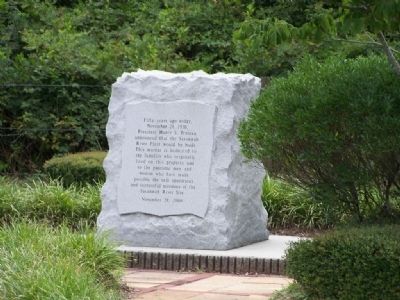
On Atomic Road (State Highway 125) near Government 3, on the right when traveling south.
Fifty Years ago today, November 28, 1950, President Harry S. Truman announced that the Savannah River Plant would be built. This marker is dedicated to families who originally lived on this property and to the patriotic men and woman who have made . . . — — Map (db m10001) HM
On South Main Street (State Highway 19) near Williston Road (U.S. 278), on the right when traveling east.
The Savannah River Plant (SRP) was built 1950–56 by Du Pont for the Atomic Energy Commission. SRP, a nuclear production plant, produced tritium and plutonium for national defense during the Cold War. Creating a 310-sq.-mi. site in three . . . — — Map (db m9941) HM
On Barton Road at Boylan Street, on the right when traveling south on Barton Road.
(Front)
This African-American community was established in 1930 after two floods on the Savannah River washed away most of the town of Hamburg. That town had become a predominantly African-American community after the Civil War. Carrsville . . . — — Map (db m238689) HM
On River North Drive east of Sapelo Drive, on the left when traveling east.
Former location of the WJ Rutherford & Co brick manufacturing yard established circa 1895-1896 in Hamburg, SC. In addition to manufacturing high quality brick the company were dealers of lime, cement, roofing, etc. The clay used to manufacture the . . . — — Map (db m238710) HM
On RiverNorth Drive at Jefferson Davis Highway (U.S. 78), on the left when traveling east on RiverNorth Drive.
Hamburg, located in the surrounding area, was a thriving river port and trading center for cotton and tobacco. Founded in 1821 by Henry Shultz and incorporated on Dec. 19, 1827, Hamburg became the most important interior port in S.C. With changing . . . — — Map (db m238700) HM
On Carolina Avenue north of West Arlington Heights, on the right when traveling north.
The Hampton Terrace Hotel, an exclusive winter resort, stood atop this hill from 1903 to 1916. The $536,000, 5-story hotel boasted more than 300 rooms and was the dream of James U. Jackson (1856-1925), founder of North Augusta. A private . . . — — Map (db m31103) HM
On West Forest Avenue at Carolina Avenue, on the right when traveling east on West Forest Avenue.
After the Civil War, the nearby Town of Hamburg, SC became a town where free blacks and freed slaves settled. Important local government positions were held by African-American leaders from the Town of Hamburg. The most notable were Prince . . . — — Map (db m274006) HM
On Georgia Avenue (U.S. 25) near Savannah River, on the right when traveling south.
James U. Jackson Memorial Bridge
The first North Augusta bridge was built in 1891 by James U. Jackson. The present bridge, built in 1939, was formally dedicated as "The James U. Jackson Memorial Bridge." The building of the 1891 bridge, the . . . — — Map (db m31662) HM
On Carolina Avenue at Georgia Ave., on the right when traveling north on Carolina Avenue.
James Urquhart Jackson, founder of North Augusta, was born in the village of Harrisonville, near Augusta, Georgia, on June 24, 1856. It was his vision that shaped North Augusta's early years.
In 1890 Jackson acquired 5600 acres of land . . . — — Map (db m10050) HM
On Georgia Avenue (U.S. 25) near West Main Street, on the right when traveling south.
Korea
1950 — 1953
Dedicated to the men
and woman who bravely
fought in "The Forgotten
War". The first war to
end the spread of
communist tyranny
throughout the world. — — Map (db m31364) WM
On West Forest Avenue at Carolina Avenue on West Forest Avenue.
Lookaway Hall. A fine local example of the Beaux Arts style, Lookaway Hall was built in c.1900 for Walter Mixer Jackson. The white-columned mansion is distinguished by its two-story wraparound portico and prominent siting. Family tradition . . . — — Map (db m274028) HM
(South face):
Dec. 4,1852 - July 8, 1876
———
In Memory of
Thomas McKie
Meriwether.
Who on 8th July 1876,
gave his life that the
civilization builded by his
fathers might be preserved
for their . . . — — Map (db m10170) HM
On Georgia Avenue (Business U.S. 25) near West Clifton Avenue, on the right when traveling south.
Mexican War
1846 — 1848
Dedicated to the brave men of
South Carolina who along with
other Patriots willingly
served that the Nation might
expand its western horizons.
Of these men who willingly
volunteered to fight a . . . — — Map (db m30980) WM
On W Forest Avenue, on the right when traveling east.
North Augusta, chartered in 1906, includes the site of two early towns. Campbell Town was a trading post on the Savannah River before the American Revolution. Hamburg, founded in 1821 as a port on the river, was an early western terminus of the . . . — — Map (db m9672) HM
On Carolina Avenue south of Butler Avenue, on the right when traveling north.
This was the site of the North Augusta station of the Augusta-Aiken Railway, a trolley line that opened in 1902. It was one of only three "interurbans" in S.C., electrified railways that connected distinct urban areas. The 26-mi. line ran between . . . — — Map (db m291969) HM
Near Railroad Avenue just west of Riverside Boulevard (North Augusta Greenway), on the right when traveling west.
The City of North Augusta was commissioned in 1906, but construction of the industrial district began earlier, in the 1890s. Factories and industrial properties were located in the bottomlands, while residential areas lined the hills overlooking . . . — — Map (db m238833) HM
Near Railroad Avenue just west of Riverside Boulevard (North Augusta Greenway), on the right when traveling west.
Since the late 1700s, the Edgefield District, located in present-day Aiken and Edgefield Counties, was well known for the production of distinctive pottery. Known as alkaline-glazed stoneware because of its characteristic glaze and the hardness of . . . — — Map (db m238837) HM
On Barton Road north of Boylan Street, on the left when traveling south.
(Front)
Providence Baptist Church was established by enslaved and free people of African descent in the town of Hamburg. After the Civil War Hamburg became a center of African American political power in Aiken County. In 1868 three members . . . — — Map (db m238687) HM
On Georgia Avenue near West Clifton Avenue, on the right when traveling south.
Our fight for Independence
that assured us Freedom of
Speech, Religion, the Press,
Right to Peaceful Assembly
and right to Petition for
Redress of Grievances. We
enjoy our present freedom
because of the willingness
of our . . . — — Map (db m30819) HM
Born 1757 in Virginia, this Indian fighter, who later moved to Edgefield District, attained the rank of Lieutenant Colonel of state troops during the American Revolution. Among the engagements he participated in were: Hanging Rock, Musgrove’s Mill, . . . — — Map (db m9800) HM
"Soul Music Queen" Rhythm & Blues Legend The Sharon Jones story begins and ends in North Augusta. Born May 4, 1956, she lived in North Augusta during her early years. She first sang publicly as an angel in a Christmas pageant at North . . . — — Map (db m234319) HM
On Georgia Avenue near West Clifton Avenue, on the right when traveling south.
Spanish American War
1898
The battle with the
slogan "Remember the
Maine", brought the
United States as a
great power and the
beginning of overseas
recognition. — — Map (db m31208) WM
On West Forest Avenue at Carolina Avenue, on the right when traveling east on West Forest Avenue.
The Hamburg Massacre occurred nearby on July 8, 1876. A gun battle occurred between about 200 men from local rifle clubs and African-Americans serving in Company A, Ninth Regiment of the South Carolina National Guard and others barricaded in a . . . — — Map (db m274009) HM
On Barton Road at Boylan Street, on the right when traveling south on Barton Road.
The Hamburg Massacre, which occurred nearby on July 8, 1876, was one of the most
notable incidents of racial and political violence in S.C. during Reconstruction. White Democrats across the state organized “rifle clubs” to intimidate black and . . . — — Map (db m238696) HM
On West Martintown Road (South Carolina Route 230) north of Southwood Road, on the left when traveling north.
In the 1730s, an Indian path from Fort Moore to the Saluda ridge was used by traders going to the Cherokee Nation. Later, a wagon road from Ninety Six to Augusta followed the same route. Named for the Martin family who lived beside it and served . . . — — Map (db m203774) HM
On West Forest Avenue at Carolina Avenue, on the right when traveling east on West Forest Avenue.
In 1914, the S.C. Legislature passed a bill authorizing $400 for a headstone on the grave of Thomas McKie Meriwether. A 1915 amendment authorized placing the monument within the town of North Augusta. Local leaders chose this prominent location . . . — — Map (db m274012) HM
On Georgia Avenue near West Clifton Avenue, on the right when traveling south.
War Between The States
1861 — 1865
Let the stranger who may in
future times read this
inscription recognize that
these were men whom power
could not corrupt, whom death
could not terrify, whom
defeat could not dishonor, . . . — — Map (db m31127) WM
On Georgia Avenue (U.S. 25) near West Main Street, on the right when traveling south.
World War I
1914 — 1918
Dedicated to the men
and women who served
in the great war which
was believed to be the
final war of human
liberty and the "war to
end all wars". — — Map (db m31243) WM
On Georgia Avenue (U.S. 25) near West Main Street, on the right when traveling south.
World War II
1941 — 1945
Dedicated to the men and women
who battled globally to
secure a free world for
all mankind. The massive
production war effort caused
many women to enter industry
and changed the American . . . — — Map (db m31269) WM
Near Front Street at Crystal Lake Drive, on the left when traveling west.
This park is constructed in honor of Charles Boeckh, civil engineer, who was commissioned in 1891 by city founder, James U. Jackson, to lay out the town plan for North Augusta. — — Map (db m196767) HM
Near Front Street just west of Westo Street, on the left when traveling west.
For more than 10,000 years, people have lived along the Savannah River. Stone spear points and tools have been found along both the South Carolina and Georgia shorelines, indicating a long history of hunting and gathering. The earliest pottery in . . . — — Map (db m240333) HM
Near Front Street at Blue Clay Drive, on the left when traveling west.
About 1,000 years ago Native Americans settled at this location. We know these people as the Mississippians, and they lived throughout the Southeast and the Mississippi Valley. They built large villages and ceremonial earthworks along major rivers. . . . — — Map (db m238988) HM
Near Front Street just west of Phoenix Street, on the left when traveling west.
By the time the first Europeans settled in the North Augusta area in the early 1700s, it was clear that the Savannah River was both their livelihood and their connection to the outside world. They fished the river, as their Native American . . . — — Map (db m239494) HM
On West Railroad Avenue, on the right when traveling north.
Commemorative
In Recognition of those of
Perry serving in the
U.S. Armed Forces
and in memory of those
who lost their lives.
Erected Oct. 8, 1988 — — Map (db m50340) WM
On John Nunn Highway (State Highway 389) 0.5 miles east of Poole Road, on the right when traveling east.
Indian Head. The Indian Head, a series of springs at the head of Goodland Swamp, long served as a landmark and watering place. Travelers along the Middle Road referenced it and it appears on colonial plats. In 1781 Loyalists under command of . . . — — Map (db m102914) HM
On West Railroad Avenue (State Highway 39) near Pine Street, on the left when traveling north.
(Front)
A patriot and Christian
devoted to his country, his
family and his god.
He served his country well
as a member of Hart's Battery
and died loving the cause
for which he fought.
Dempsey Hammond Salley was
. . . — — Map (db m47645) HM
On Wagener Road (South Carolina Route 302), on the left when traveling north.
(Front) The congregation of Zion Hill Missionary Baptist Church originated c.1894, when
tradition holds that members began worshipping at a brush arbor across the road. Rev. James
Turner was the first pastor. Early church leadership included men . . . — — Map (db m239261) HM
On Sand Dam Road (South Carolina Route 113) at A.L. Corbett Circle, on the right when traveling south on Sand Dam Road.
A.L. Corbett School for grades 1-12 opened at this site in 1954. The $600,000-facility was funded by the state equalization program, an effort to preserve segregation by improving African American schools. It enrolled 785 students in its first . . . — — Map (db m292194) HM
On Wagener Road (State Highway 302), on the right when traveling west.
(Left)
Herbert Boyd (H.B.) Crawford
U.S. Navy
Honorably Discharged
April 8, 1946
During World War II with Japan
his back was broken & both
legs were paralyzed when his
cargo ship was torpedoed
(Right)
Mabel . . . — — Map (db m56751) HM
On Railroad Avenue E (State Highway 39) near Park Street NE, on the right when traveling west.
Wagener, established after the Blackville, Alston, & Newberry RR built its line from Blackville to Seivern in 1887-88, was originally known as Guntersville or Gunter´s Crossroads. When incorporated in 1888 it was renamed for George A. Wagener . . . — — Map (db m67342) HM
Front
In Honor and Memory of Heroes of Wagener Past and Present
Seals of: United States Army; United States Marine Corps; United States Navy; United States Air Force; United States Coast Guard; POW * MIA
On Top
Blue . . . — — Map (db m54850) WM
On Lee Street N. near Old Ninety Six / Indian Trail ( Highway 39), on the right when traveling west.
Prior to 1887 the area now known as the Wagener
Community was called Guntersville, and its residents
were primarily engaged in agriculture, for their
livelihood. The coming of the railroad, "The Swamp
Rabbit", in 1887 drew farmers, . . . — — Map (db m40428) HM
On Huber Clay Road (State Highway 66) at Shephard Estates Drive, on the left when traveling south on Huber Clay Road.
Jacksonville School
Jacksonville School, built by the Jacksonville Lodge in 1895, taught the black children of this community until 1936. Grades 1-7, with two teachers, met in two classrooms on the first floor, without electricity or running . . . — — Map (db m31175) HM
On Flint Drive (State Highway 731) west of Bryan Drive, on the right when traveling east.
Jefferson High School Jefferson High School opened in 1956 as a junior high and high school for African-American students of Beech Island, Belvedere, Graniteville, Jackson, Langley-Bath-Clearwater, and North Augusta, with Herman W.W. Fennell . . . — — Map (db m31675) HM
On Court Circle (Route S-3-81) north of Pine Streeet, on the right when traveling north.
Allendale Co. Jail. In 1919 the S.C. General Assembly issued $100,000 in bonds to fund construction o a jail and courthouse in the newly established Allendale County. Both were designed by Atlanta-based architect G. Lloyd Preacher, a Fairfax, . . . — — Map (db m301367) HM
Organized in 1833 by Dr. and Mrs. W.R. Erwin and Mrs. U.M. Robert, this was the second Christian Church (Disciples Of Christ) founded in South Carolina. Dr. J.D. Erwin, II, served as minister for forty years. The present building was used . . . — — Map (db m19635) HM
On State Highway S-3-104 0.3 miles south of State Highway S-3-92, on the right when traveling south.
Constituted September 12, 1759 as Coosawhatchie Church, this church became in 1882 Beech Branch Baptist Church. The present lot was granted in 1796 and occupied by 1815. The building was remodeled in 1908 and in 1960, electricity having been . . . — — Map (db m15466) HM
On Railroad Avenue W (State Highway 3-10) near Memorial Avenue (State Highway 3-71), on the right when traveling west.
This church, founded soon after the Civil War, held its first services in a brush arbor in the Woods community of what was then Barnwell County. It built its first permanent church, a frame building, in the Zion Branch community near Old . . . — — Map (db m49489) HM
On State Highway 3-47 at SC S-3-107, on the left when traveling west on State Highway 3-47.
Original site of Allendale, named for its first postmaster, Paul Allen, in 1849. Sherman's troops under Gen. Kilpatrick camped here. Town moved to present site by 1873. — — Map (db m15914) HM
On Bluff Road (State Highway S-3-22), on the right when traveling north.
Organized in 1827 as Kirkland Church, the name was changed in 1836 to Smyrna Baptist Church. Title to the site was conveyed in 1849 by William I. Mixon.
Additional land was given by Thomas H. Willingham in 1882 to extend the church property to . . . — — Map (db m15581) HM
On Walnut Street West west of Memorial Avenue South ( Road S-3-8), on the right when traveling west.
This church is first organized c. 1815, when members met in a log house 2. mi. S that was adjacent to a sheet of water known as "Swallow Savannah," the church's namesake. Local preacher John McFail was likely instrumental in the church's . . . — — Map (db m301365) HM
On South Main Street (U.S. 301), on the right when traveling south.
In 1810, pursuant to an Act of the South Carolina General Assembly, the state conveyed a 1000 acre landgrant signed by governor John Drayton to Benjamin and G. Washington Allen. The acreage included the present town of Allendale, which is . . . — — Map (db m6537) HM
On Allendale-Fairfax Highway (U.S. 278) near Laurens Avenue North, on the left when traveling west.
In Memory
Of
War Dead
Of
Allendale County
Dedicated June 1954
to the memory of
brave men, who died
that their country
might live — — Map (db m16900) HM
On North Aiken Ave at Revolutionary Trail on North Aiken Ave.
This Baptist Church, organized by 1854, built its first house of worship near here on land purchased in 1859 from A.R. Stokes. The congregation obtained the land for its present location in 1910 from G.D. Sanders and completed by 1914. In 1944 the . . . — — Map (db m9960) HM
On 7th Street near Sumter Avenue South, on the right when traveling east.
[front text]
Fairfax, chartered in 1893 and
incorporated in 1896, grew out of
an early community centered around
Owens' Crossroads, where a store
was established in 1814, and later
including Bethlehem Baptist Church
( now First . . . — — Map (db m7082) HM
On Jenny Road (State Highway 3-40) near Harmony Church Road (State Highway 3-134), on the right when traveling east.
This church had its origins in a brush arbor as early as 1830 but was formally organized in 1878 with Rev. H. C. Smart as its first pastor and W. H. Cone and R. H. Mixon as its first deacons. Named Harmony Baptist Church by charter member Sarah . . . — — Map (db m25859) HM
On Speedwell Church Road (State Highway 3-369) near Little Hell Road, on the right when traveling west.
(Front text) This church, founded in 1885, was named Speedwell for a stagecoach stop and the first post office in the vicinity, now Millett. In 1884-85 Ogreta Brabham Dunbar and Savannah Barker Bates raised funds for a new congregation, in . . . — — Map (db m37789) HM
On Buford's Bridge Highway (U.S. 321), on the left when traveling north.
(Barker's Mill side of marker):
Barker's Mill, which stood here on
Jackson Branch, was a grist mill
owned by William Ransome Barker
(1816-1869), a planter in what was
then Barnwell District. Barker moved
to this are in the . . . — — Map (db m7176) HM
On Confederate Highway (State Highway 640) at Bethel Church Road (State Highway S-3-106), on the right when traveling east on Confederate Highway.
(Front Text )
This church was organized in 1851 by Revs.
Lewis Parker and John Hoover, with twelve
charter members and Rev. Hoover as its
first minister. The congregation has
worshipped on this site, on land donated
by Mathias . . . — — Map (db m7771) HM
On Confederate Highway (State Highway 641) at Ulmer Road (State Highway 3-48), on the left when traveling west on Confederate Highway.
The original cemetery associated with St.
Nicholas Lutheran Church is 1/3 mile S off
SC Hwy 641. The church, originally located
nearby, was founded about 1804 in what was
then Barnwell District, and the cemetery
includes family plots of the . . . — — Map (db m7855) HM
On Confederate Highway (State Highway 641) at Jenny's Road (State Highway S-3-40), on the right when traveling north on Confederate Highway.
Lutheran church, org. by 1804, has occupied
several sites. Today's structure, built in 1910,
incorporates material from the 1884 church and
stands about 2 mi south. — — Map (db m7842) HM
The history of the brass cannon reflects the history of the Upstate of South Carolina during some of its most critical eras of conflict and change. The "Old Reformer" is also one of the oldest artifacts in the Upstate, since it arrived here . . . — — Map (db m42194) HM
On South Manning Street at East Church Street, on the right when traveling south on South Manning Street.
This area planted in appreciation of
Mr. & Mrs. Wilton E. Hall
who since April 7, 1955 have contributed the facilities of radio stations WAIM & WCAC-FM to carry the ministry of this class to many thousands of people each Sunday morning. . . . — — Map (db m107216) HM
On East Calhoun Street north of Boulevard (U.S. 29), on the left when traveling north.
This building was made possible by the
generous support of
The Abney Foundation
and
John R. Fulp, Jr.
It will forever serve as a tribute to the dedication and work of the many thousands of men and women who are a part of the . . . — — Map (db m19810) HM
On East Church Street west of South McDuffie Street.
“At night it would be so packed you had to walk, you couldn't get a car down Church Street. Sometimes there would be a little disturbance but things mostly got worked out. Eventually we got two black cops, Bobby Clinkscales and . . . — — Map (db m185370) HM
On South McDuffie Street, on the right when traveling north.
This archway
formerly stood at the
entrance to
Anderson Boys'
High School
"Home of the Yellow Jackets"
Anderson Boys' High School
was located on this site.
The school educated many of
our city's young men from
the year . . . — — Map (db m59359) HM
On Kingsley Road, on the right when traveling north.
Presented by
Mr. & Mrs. Rex Rice
of
Belton, South Carolina
in
1960
for the Advancement of Christian Education and to the Glory of God. — — Map (db m19812) HM
This is Anderson County's second court house. It stands on the site of the first small brick court house where the first court session in Anderson was held on the third Monday in October, 1820. The present building of pronounced Victorian . . . — — Map (db m10692) HM
On South Fant Street (State Highway 22) at East River Street (U.S. 76), on the right when traveling north on South Fant Street.
The location of the Anderson County Courthouse Annex on the corner of Fant and River Street has unique significance to Anderson's history. The site is the location of the 1865 federal encampment of the First Maine, 33rd Regiment, United States . . . — — Map (db m19838) HM
This Building was originally constructed in the 1930's for use as the Anderson Petroleum Company. It was renovated in the fall of 2005 to be the new home of the Anderson County Farmers Market Pavilion.
2005 Anderson County
Farmers Market . . . — — Map (db m42257) HM
On Freedom Way at County Road 16, on the right when traveling south on Freedom Way.
Remembering those that gave
their lives protecting people
and property
----------
"...We are the defenders from fire, of the art which has beautified the world, the product of the genius of man and the means of refinement of mankind. But, . . . — — Map (db m19915) HM
A memorial to the Memory of the law enforcement officers of Anderson County South Carolina who gave their lives in the line of duty. Their valor and sacrifice will be long remembered.
William Gibson Anderson Police Dept. . . . — — Map (db m11399) HM
For over a decade, the Board of Trustees, the staff, and Friends of the Anderson County Library have pursued a dream of building a library adequate in size and scope to meet the needs of the community. Today, the original Carnegie-endowed Anderson . . . — — Map (db m81274) HM
This monument is dedicated to the war veterans of Anderson County. On its walls are listed the names of our natives who served in World War I, World War II, the Korean War, the Vietnam War, and the Persian Gulf War. In addition, the monument lists . . . — — Map (db m21367) WM
On Glenn Street at King Street on Glenn Street. Reported missing.
Founded in 1888, Anderson Cotton Mills, later a division of Abney Mills, was the first textile plant established in the town of Anderson. It is said to be the first textile mill in the United States powered by electricity transmitted over long . . . — — Map (db m52093) HM
Anderson Presbyterian
Church Cemetery
Founded 1837
Land Given by
Judge J.N. Whitner
Used as the First
Public Burial Ground
For the Village — — Map (db m49496) HM
The first municipal airport in Anderson was just a grassy field located near where the Civic Center now stands. An historical marker notes the site where Amelia Earhart landed there on November 14, 1931.
In the early 1930s land was purchased . . . — — Map (db m53938) HM
On South Main Street (State Highway 28) at West Whitner Street (State Highway 24), on the right when traveling west on South Main Street.
Front:
Anderson was dubbed "The Electric City" in 1895 when William C. Whitner, an engineer and native of Anderson, built a hydroelectric power plant which was the first in the South to transmit electricity over long distances. The . . . — — Map (db m10693) HM
On East Benson Street at South Main Street ( Highway 28), on the right when traveling east on East Benson Street.
This building was erected as the home of the Bank of Anderson, an outgrowth of the Anderson National Bank founded in 1872 with Col. Joseph Newton Brown as president. The early bank was located on the west side of the square. It was the second . . . — — Map (db m21221) HM
Near North Main Street (U.S. 29), on the right when traveling north.
This building was erected as a passenger station for the Blue Ridge Railroad. It bridges the railroad cut under North Main Street which was excavated by the Blue Ridge Railroad Company as part of a project to build a line over the mountains to . . . — — Map (db m94745) HM
On West Market Street west of South Prevost Street, on the right when traveling west.
This Victorian home was built by J. Thomas Bolt, great nephew of Oliver Bolt who operated the first electrified cotton gin in the world. J. Thomas Bolt was a cotton merchant, and owned B&B Motor Company. — — Map (db m185517) HM
On East Greenville Street (State Highway 81), on the right when traveling north.
The original Anderson High School sat on the corner of North Fant and East Calhoun Streets. All grade levels were taught despite being called a high school. This school burned down in 1904 and was rebuilt the following year. Due to overcrowding, . . . — — Map (db m65305) HM
Building History
Built in the 1930s by Frank R. Thompson, this building was the main street depot for the Anderson Petroleum Company and Dixie Distributors, Inc., both successful petroleum distributors in Anderson, Oconee, Pickens, . . . — — Map (db m42762) HM
This building constructed in 1912
is named in honor of
Dr. Annie Dove Denmark
associated with Anderson College for
36 years, serving as President of the
college from 1928-1953. Dr. Denmark
was a resident of this dormitory
during . . . — — Map (db m19738) HM
On Due West Highway (State Highway 185) at County Road 17-60A, on the left when traveling west on Due West Highway.
[Front]:
This church, formally organized by about 1800, is thought to be the oldest Methodist congregation in Anderson County. Circuit riders and other itinerant ministers held early services in a nearby brush arbor. Its first and second . . . — — Map (db m55621) HM
On North Main Street, on the left when traveling south.
This store is the oldest business firm in Anderson. It has been owned and operated consistently by the same family for 175 years. Established by George W. Fant and originally named G.W. Fant & Son the store is an outgrowth of Dr. Edmund Webb's Drug . . . — — Map (db m21292) HM
Near Anderson Independence Mail Boulevard west of Freedom Way.
Famous aviator Amelia Earhart landed on an airfield near here on November 14, 1931. She was piloting a Beechnut Autogiro on a nation wide tour promoting Beechnut Products. It was shortly after completing this tour that she made her famous solo . . . — — Map (db m21250) HM
On West Whitner Street (State Highway 24) west of Towers Street.
Organized Sept. 23, 1837 on land given by J. N. Whitner. First frame structure was built in 1839. Anderson's first cemetery is here, and city's first Sunday School was organized here about 1855. Present sanctuary's cornerstone was laid in 1879. . . . — — Map (db m10727) HM
On Flat Rock Road at Glen Eddie Road ( Highway 475) on Flat Rock Road.
Serving Country
and
Jesus Christ
Veterans Who Are buried
in Flat Rock Cemetery
[Left Column]
Harry Drake, Daniel Y. Culbertson, J.C. Culbertson, Luther M. Borders, John T Neims, Charles A. Thornton, Berry Faine, Edward . . . — — Map (db m54779) HM
5380 entries matched your criteria. Entries 201 through 300 are listed above. ⊲ Previous 100 — Next 100 ⊳