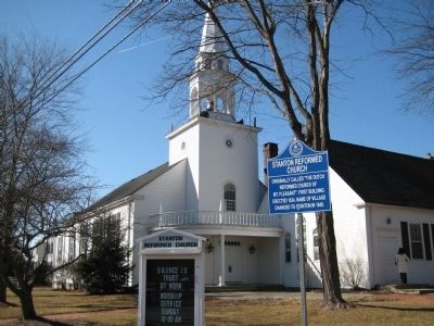
Originally called “The Dutch Reformed Church of Mt. Pleasant.” First building erected 1834. Name of village changed to Stanton in 1849. — — Map (db m16744) HM
This wall encloses a portion of a plot of two acres whereon was erected in 1704 the first Christian church within the present confines of Mercer County.
Early records refer to it as “Hopewell Church” and “Christ Church”.
It was built . . . — — Map (db m4073) HM
Organized during 1698, this Presbyterian congregation was among the earliest in America. Part of this church was built in 1764. — — Map (db m122268) HM
Betsey Stockton (1798-1865) began life as a slave for the prominent Stockton family in Princeton. When she gained her freedom at the age of 20, she became a missionary, traveling to Hawaii (Sandwich Islands), Canada and Philadelphia, teaching school . . . — — Map (db m94762) HM
The area around the meeting house and along the Stony Brook river was originally the “Stony Brook Village,” officially part of the town of West Windsor in Middlesex County. A majority of the original colonists that came to settle in . . . — — Map (db m62289) HM
In 1772, Thomas Clarke, a Quaker farmer purchased 200 acres of land from his brother William. The land, then part of West Windsor, had been in the Clarke family since 1696. Thomas replaced an existing structure with the main house that stands today. . . . — — Map (db m149800) HM
This is the third First Church, the previous two (1726 & 1804) having been built elsewhere on the lot. The burial yards flanking the church include a mass grave of Hessians killed in the first Battle of Trenton, and the grave of Col. Rall, their . . . — — Map (db m208088) HM
Trenton’s first Jewish organization, Mount Sinai Cemetery Association, formed November 19, 1857, later known as Har Sinai Hebrew Congregation, began regular synagogue services at this site in 1860. — — Map (db m3654) HM
The British occupied this site in December, 1776. Buried in its small graveyard are Revolutionary War figures, including George Clymer and General Philemon Dickinson. Clymer, a Pennsylvanian who helped finance the Continental Army, signed the . . . — — Map (db m208093) HM
Erected to commemorate that noble spirit of justice displayed by Gen. George Washington after his capture of Trenton in December 1776, in returning to both Whig and Tory alike their personal effects, of which they had been ruthlessly plundered . . . — — Map (db m3757) HM
Originally known as the English Church, St. Michael's closed for seven years during the Revolution. The church was largely rebuilt in 1819. David Brearley, a signer of the Constitution, state chief justice and Washington's appointee as New Jersey's . . . — — Map (db m208095) HM
1790 — Trenton named capital of New Jersey.
John Fitch’s steamboat makes Trenton–Philadelphia trips three days a week.
1792 — State House opens.
Assembly meets in State House for first time.
1799 — President . . . — — Map (db m3985) HM
Born April 16, 1814, in Tuckerton, NJ.
He operated country general stores throughout Burlington and Monmouth Counties before moving to Trenton.
He served as Chancery Court clerk of New Jersey from 1851 to 1856 and served as mayor of Trenton . . . — — Map (db m9891) HM
Circa 1766, Home of Alexander Douglass, Quartermaster in Washington’s Army, who fought in the Battle of Assunpink, Jan. 2, 1777.
Here on that date General Washington held the Council of War. Washington’s idea was to leave campfires burning on . . . — — Map (db m3746) HM
A Bicentennial commemorative site recognizing America’s 200th year of liberty
Mount Zion A.M.E. Church
The Oldest Black Church in Trenton
Incorporated by slaves and freedmen 1811
Original edifice this site 1819
Member Founding . . . — — Map (db m4945) HM
In memory of
Rev. John Rosbrugh
Clerical Martyr of the Revolution
Moderator of the
Presbytery of New Brunswick
1776
Chaplain 3d Battalion
Northampton County PA Militia
December 25, 1776
Bayoneted to death by Hessians
in . . . — — Map (db m4006) HM
A Bicentennial Commemorative Site recognizing America's 200th year of liberty
Organized 1712
Present Building erected 1839
We are bound to God’s will
(On another marker nearby on the front porch:
Presbyterian Church
Formed 1712 . . . — — Map (db m3993) HM
Founded in 1856, the Trenton YMCA was initially located in homes and public buildings throughout the city. In 1892, with volunteer leadership and total community support, the YMCA built their first consolidated facility on this site. By 1916, the . . . — — Map (db m3992) HM
(To the right of the front door):
A Bicentennial commemorative site recognizing America’s 200th year of liberty
Church of the Sacred Heart
New Jersey’s oldest Catholic parish
Successor of St. John’s 1814
(To the left of the . . . — — Map (db m4060) HM
Seeking refuge from religious persecution in England, Quakers John Fenwick and Edward Byllynge buy West New Jersey from John, Lord Berkeley. — — Map (db m211651) HM
A Quaker monthly meeting convenes for the first time at the Falls of the Delaware in the house of William Biles near present day Morrisville. — — Map (db m211659) HM
In the 1670s and 1680s, most of the proprietors of the Province of West Jersey were Quakers. Quakers were attracted to the new colony by the promise of economic prosperity and religious freedom as well as the opportunity to raise families in a . . . — — Map (db m166122) HM
Between 1674 and 1702, the province of West New Jersey was owned and governed by a group of men collectively known as the West Jersey Proprietors. The first proprietors were two Quakers, Edward Byllynge and John Fenwick, who acquired rights to half . . . — — Map (db m166132) HM
Europeans and Africans moving into the Middle Delaware valley in the late 17th and 18th centuries professed and practiced a variety of religious faiths. In the case of the incoming European settlers, most held to some form of Protestant Christian . . . — — Map (db m239791) HM
First Mass held in School No. 4
First church dedicated 1939
Served former Rahway Prison &
Woodbridge Development Center
Current church built 1956
Est. September 1920 — — Map (db m206822) HM
Civil War MonumentThe Civil War Soldiers Monument in this cemetery, located behind the church building complex, is one of New Jersey’s earliest Civil War monuments. On June 3, 1865, Reverend Joseph Gaston Symmes of the First Presbyterian Church . . . — — Map (db m122264) HM WM
The Sexton's House
The adjacent private home located at 3 Westminster Place was constructed in 1840 as the home of the Sexton of the Church. As with most historic homes in Cranbury, this house has been modified since its original . . . — — Map (db m95880) HM
St. James Episcopal Church was established in 1704. The original structure was built in 1724. In 1835 the church was destroyed by a tornado. It was rebuilt using as much of the original wood and fixtures as possible. The rear section was built in . . . — — Map (db m53332) HM
Uniontown, early Iselin label
Named for Church's Union Society
Green Street Union Chapel 1864
Church at current site 1923
Expanded 1954
1859 — — Map (db m208858) HM
Designated mission church of
St. Mary's 1915
First Church 1923
Parochial School 1951-2012
Church/School built 1953
Modern Church consecrated 1989
1914 — — Map (db m208856) HM
Congregation Anshe Emeth was founded October 11, 1859. It was the first incorporated Jewish congregation in Middlesex County, and the fourth in New Jersey. The congregation, which followed American Reform liturgical practices, built New Brunswick’s . . . — — Map (db m94036) HM
Christ Church, founded in 1742, was entered onto the National Register of Historic Places in July 28, 1989. In 1776, the third public reading of the Declaration of Independence was made from the foot of the church tower. Funding for the Exterior . . . — — Map (db m94014) HM
Christ Church Parish was organized in 1742 through the efforts of the Society for the Propacation of the Gospel in Foreign Parts-Samuel Seabury First Bishop in America 1754 Rector 1757-Abraham Beach active in the organization of the Episcopal Church . . . — — Map (db m94018) HM
Kirkpatrick Chapel, designed by Henry Janeway Hardenbergh (great-great-grandson of the first president of Rutgers, also the architect of Geology Hall), was built as a chapel and library. The library was removed in 1903, thus increasing the . . . — — Map (db m10016) HM
Built in 1873 in the High Victorian Gothic Revival style, this chapel was designed by New Brunswick native, Henry J. Hardenbergh, the great-great-grandson of Rutgers' first president, Rev. Jacob Hardenbergh. Its vibrant glass windows are some of the . . . — — Map (db m208911) HM
Rutgers
The State University of New Jersey
Queen’s Campus
1809
Queen’s College (now Rutgers University) opened for instruction in 1771 in a tavern known as “the Sign of the Red Lion” on the corner of . . . — — Map (db m10040) HM
Listed in The New Jersey and National Register of Historic Places 2005
Restoration work funded in part by a grant from the Garden State Historic Preservation rust Fund, administered by the New Jersey Historic Trust, State of New Jersey . . . — — Map (db m208915) HM
The oldest Catholic congregation in Middlesex County. St. Peter's was founded in 1829 by Bishop John DeBois of New York in a humble brick building on Bayard Street. The current stone Gothic Revival structure was designed by prominent architect of . . . — — Map (db m188171) HM
From 1811 to 1856 students preparing for ministry in the Reformed Church in America received their theological education in Old Queens.
Erected on the occasion of the Bicentennial of New Brunswick Seminary
1784-1984 — — Map (db m10072) HM
St. Peter’s is the oldest parish in the state. Founded in 1698 when the Bishop of London sent the Rev. Edward Portlock to be its’ minister. Chartered in 1718 by King George I. Used as a barracks for British troops in 1776. Here the colonial . . . — — Map (db m7901) HM
Organized, 1698, St. Peter’s is New Jersey’s oldest Episcopal Parish. Royal charter, 1718. Churches on this site in 1722 and 1852. — — Map (db m7899) HM
Chartered in 1848, the United Methodist Church was the first religious congregation in the part of South Amboy that would be incorporated as Sayreville in 1876. Methodism came to this area through a circuit rider—a minister on horseback . . . — — Map (db m93914) HM
Est. 1913 by Sewaren
History Club and Civic Assoc.
Current location since 1960
Originally built as
Christian Science Church
1920 — — Map (db m192501) HM
St. Mary’s parishioners built the school nearby at great sacrifice and dedicated it to Mary, Mother of God, in 1903. St. Mary’s served ten surrounding parishes during peace-time, wars and other catastrophes.
This marker placed in 2002 calls out . . . — — Map (db m93913) HM
The First Baptist Church, the oldest religious institution in South Plainfield, was founded by local Baptists in 1792 as the Samptown Baptist Church. The first church building was constructed in the same year outside the colonial hamlet of Samptown . . . — — Map (db m93972) HM
The first European settlers in this area were members of the Society of Friends (Quakers), who came from the regions around the cities of Edinburgh and Aberdeen in Scotland. Encouraged by the East Jersey Board of Proprietors, they made their homes . . . — — Map (db m93984) HM
Site of an early colonial burial ground associated with the hamlet of Samptown. This place was chosen by local Baptists to be the location of the meeting house of the newly formed Samptown Baptist Church in 1792.
The first church building was . . . — — Map (db m93988) HM WM
This picturesque Gothic Revival style building executed in wood is St. Peter's second church. Built in 1849-51, the current structure replaced a smaller church built on this site in 1756-1759. The design of the new church departed from traditional . . . — — Map (db m95754) HM
Congregation Adath Israel Synagogue served Woodbridge’s Jewish community from 1907 until its 2006 merger with Congregation Neve Shalom of Metuchen. The Conservative congregation first High Holy Days services were celebrated by a small group at . . . — — Map (db m124573) HM
The first meeting house for religious purposes was built here on the ‘Kirk Green’. Replaced by the present church in 1803 and built by Jonathan Freeman, it is known as the Old White Church. 1675 — — Map (db m62707) HM
By the Grace of God, “A building about thirty feet square unpainted inside and out, with no steeple or bell without and no stove within” was erected on this place in 1675 to serve as both a community church, town hall and burial ground . . . — — Map (db m122272) HM
A house of worship has stood on this site since 1675. In that year a religious meeting house was built which was also the seat of Woodbridge Township government. The founders of Woodbridge were Puritans and the church was non denominational until . . . — — Map (db m62710) HM
The First Presbyterian Church of Woodbridge is home to the oldest Presbyterian congregation in Middlesex County and the sixth oldest in the state. Located at 600 Rahway Avenue and known as “The Old White Church”, its first service was conducted . . . — — Map (db m125836) HM
Fulton Street Neighborhood
The historic neighborhood enclosed by Fulton, Second, Albert and Smith Streets were first surveyed and mapped in 1840 by Ichabod Potter. The section was home to working-class residents, many of the German, Irish and . . . — — Map (db m125972) HM
One of the most distinctive buildings in Woodbridge is the Italianate-style mansion at the top of Strawberry Hill on Amboy Avenue – the home of 19th-century clay magnate Hampton Cutter (1819-82). Located on the site of many significant . . . — — Map (db m126840) HM
The United Methodist Church and Parsonage at 69-71 Main Street represents one of the oldest religious communities in New Jersey. In March 1772, Rev. Francis Asbury, founder of the Methodist Church in America, preached to Woodbridge Methodists in . . . — — Map (db m125781) HM
The community of Port Reading took shape in 1892 when the Reading Railroad extended its line to docks on the Arthur Kill, where coal arriving by train from Pennsylvania was sent off to New York and New England by barge. Many of the workers . . . — — Map (db m126834) HM
St. James Roman Catholic Parish
First mass, 1683
School opened, 1890
Church relocated from Upper Main Street, 1924
New church dedicated, 1968 — — Map (db m195829) HM
St. John’s Episcopal Church
The first church built in Sewaren was St. John’s Episcopal Church, located at Woodbridge Avenue and Cliff Road. Established in 1892 by Trinity Episcopal Church in Woodbridge as “a chapel of convenience”, . . . — — Map (db m126560) HM
The Parish Community of St. James
The history of St. James Roman Catholic Church began in the late 17th century, when many French and Irish immigrants were drawn to Woodbridge following the discovery of a fine type of potter’s clay in the area. . . . — — Map (db m125512) HM
Not long after Woodbridge Township was founded in 1669, the Independent Meeting House was built nearby for nondenominational services. Records show that Anglican services were first held there in 1698. In 1710, it was announced that the Independent . . . — — Map (db m62703) HM
First used for burial in 1714.
Place of interment for many
prominent Woodbridge families
and veterans from each war beginning
with the
American Revolution
1714 — — Map (db m194312) HM WM
First service held December 29th 1703 By Rev. John Keith First Church erected about 1712 Second Church erected on old site 1754 Charter granted by King George III December 6th 1769 Second Church destroyed by fire 1858 Corner Stone of present Church . . . — — Map (db m39976) HM
Trinity Episcopal Church of Woodbridge is among the oldest Episcopal congregations in New Jersey. Now located at 650 Rahway Avenue, its first service was conducted in 1698; the first sanctuary was built in 1713 under the leadership of Rev. Edward . . . — — Map (db m126154) HM
Edward Portlock first conducted services in Woodbridge in 1698, making Trinity one of the oldest parishes in New Jersey. After fire destroyed a second building, the present church was built. Built 1861 — — Map (db m190062) HM
Methodist Episcopal Church built 1832. Present Church built 1870. Became Woodbridge United Methodist Church in 1967. Burial site of patriot Janet Pike Gage.
1832 — — Map (db m190053) HM
Listed on the New Jersey Register of Historic Places December 22, 1997 Listed on the National Register of Historic Places March 19, 1998 First Service – October 10, 1701 Construction begun on this site – July 1771 Restoration program . . . — — Map (db m53138) HM
The oldest building in continuous use in downtown Freehold 1702 First service (at Topanemus) 1736 Charter from King George II 1771 Construction began on the present building 1778 Local lore says the building sheltered wounded during the . . . — — Map (db m53136) HM
Sandy Hook Ferry Landing
Many park visitors enjoy the scenic ride on the ferry from New York City to Sandy Hook each summer. Visitors coming from the city enjoy using the ocean side beaches, campground and multi-use path.
Sandy Hook . . . — — Map (db m151975) HM
Weddings, christenings, funerals, and services of all faiths took place here in Fort Hancock’s chapel. It is one of the few surviving buildings from the pre-World War II mobilization period of 1940-41. First Sergeant Lawrence Markle, 7th Coast . . . — — Map (db m54501) HM
As early as 1700, Baptist settlers conducted worship services in this area. Church records describe the region as “a wild uncultivated place, but peopled with Indians in great abundance”. In 1720, the Baptists refitted a farmhouse on . . . — — Map (db m79450) HM
In 1720, Thomas and Rachel Saltar, owners of a nearby mill and ironworks, deeded 25 acres to early Baptist settlers in the Upper Freehold region. Since then, this site had been under the continuous care and use of the Upper Freehold Baptist Church . . . — — Map (db m79435) HM
This parsonage provided a home for the Baptist ministers at Upper Freehold. It was built in several stages with the oldest section (c.1740), now its center, containing one room on the first floor with an open-hearth fireplace and a beamed ceiling. . . . — — Map (db m79438) HM
Built in 1879.
Named for the seven U.S. Presidents who attended services here: Ulysses S. Grant, Rutherford B. Hayes, James A. Garfield, Chester A. Arthur, Benjamin Harrison, William McKinley, and Woodrow Wilson.
Deconsecrated in 1953, . . . — — Map (db m14049) HM
Long Branch Post 316
Jewis War Veterans
of the USA
through whose efforts
Oceanpointe Towers was erected
dedicates this site
in honor of the men and women who have served in our nation's armed forces and in memory of those who made . . . — — Map (db m209106) HM WM
In grateful remembrance of patriots who, on Sabbath June 28,1778, gained the victory which was the turning point in the War for Independence, and to mark a memorable spot on the battlefield of Monmouth.
[Plaque located opposite main . . . — — Map (db m6172) HM
The Congregation of St. Gabriel was organized in 1871, and this church was erected in 1878. Although a new Church and Rectory were constructed in Rt. 79 in 1972 and Parish Center in the 1980’s, this building has remained in continuous use. — — Map (db m93770) HM
First known as the Reformed Church of Freehold and Middletown, it divided in 1825 and became “The First Reformed Church of Freehold.” In 1931 its name was changed to “The Old Brick Reformed Church.”
The first building . . . — — Map (db m93773) HM
Site of church and graveyard of Matawan’s original Scots settlers. The church was built in 1734. The graveyard added in 1763.
The church was burned by Tories in 1777 and the Rev. Chas. McKnight taken prisoner. The deed was held by the Monmouth . . . — — Map (db m93766) HM
Converts of George Keith, 1702, became nucleus of Episcopalian Congregation Incorporated in 1738. This edifice was built in 1769. — — Map (db m93749) HM
On this site
Christopher Reynolds
from 1743 to 1760 conducted the Christ Church School one of the earliest common schools in New Jersey — — Map (db m209048) HM
The settlement of Quakers in the colony of New Jersey is regarded as an important contribution to a progressive tradition in the state. Then as now, Quakers believed in equality and in granting women a unique role in their communities. Quakers . . . — — Map (db m93753) HM
Shrewsbury Historic District has been placed on the National Register of Historic Places in 1978 by the United States Department of the Interior — — Map (db m209046) HM
Mrs. Anna Baird, developer of Hastings Square, donated the land on East Lake Avenue for this church. A 1,500 pound bell was donated by Mr. George Griffins. The structure was built of granite and interiors of light woods. It had a seating capacity of . . . — — Map (db m6700) HM
This building was constructed in two parts with the front portion being erected about 1832 from timbers taken from the earlier Monmouth Furnace buildings. The rear section containing the altar, steeple, and bell tower, was added in 1836. A most . . . — — Map (db m53170) HM
410 entries matched your criteria. Entries 201 through 300 are listed above. ⊲ Previous 100 — Next 100 ⊳