In 1886, a rock monument was placed near here by
the Hesperia Land and Water Company. Required by
law, the monument gave notice that 5,000 miners
inches of water per minute was to be taken from
this point for use in Hesperia, enough water . . . — — Map (db m166568) HM
Mojave Indian Trail
Over 12,000 years ago the Anasazi people originally used the trail. In prehistoric times, the trail was used as a trade route to the sea. South of this area also lies the Vanyume village of Atongai, long extinct. . . . — — Map (db m166638) HM
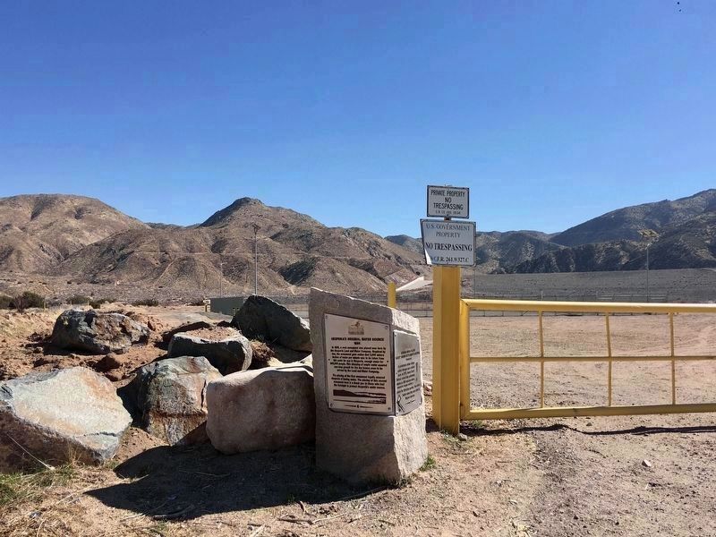
Life giving water, urgently
needed in growing Hesperia,
first arrived at this place in
1886. Flumes, pipe, and
ditches transported it seven
miles from high in the San
Bernardino Mountains.
By the 1950's, Hesperia's
water came from wells . . . — — Map (db m166556) HM
At this location, Ragtown stood as a part of the once-booming "Buckeye Mining District". One mine in the district, the Bagdad-Chase, discovered by John Suter in the 1880s, was to become the largest single source of copper and gold in San Bernardino . . . — — Map (db m163984) HM
In the late 1860's copper was discovered on Clark Montain and the Clark Mining District was organized. Ore was rich but high transportation costs soon caused mining to cease. In the late 1890's the railroad came within 30 miles and the original . . . — — Map (db m78573) HM
Gold was discovered in the nearby Castle Mountains in December 1907 by Jim Hart and the Hitt brothers, Bert and Clark. The town of Hart quickly sprang up. Its five hotels and eight saloons served a population of about 400. The relatively quiet town . . . — — Map (db m150924) HM
The Oro Grande Cemetery is one of
the oldest in the Victor Valley area
and was originally established as the
Bennette Memorial Park sometime around
1890. Mr. Bennette was a rancher who
raised stock in and around Oro Grande
up until 1894. . . . — — Map (db m245841) HM
Spanish missionaries introduced the principle of irrigation in San Bernardino Valley, thus opening the way to settlement. Franciscan Fathers engineered, and Native Americans dug, this first ditch, or "zanja", in 1819. It supported the San . . . — — Map (db m143344) HM
In 1917 a deposit of Epsom salts was discovered near the old Wingate Wash Borax Road at the southern end of Death Valley. In 1919 the claims were acquired by Los Angeles florist Thomas Wright. Although close to an existing road, Wright devised other . . . — — Map (db m78525) HM
This monument commemorates two wagon routes used by the Searles brothers to haul borax from their plant on Borax Lake (now Searles Lake) to the railhead at Mojave. The southern route traveled west of the Trona Pinnacles to Searles' freight station . . . — — Map (db m78554) HM
Rising from the bottom of what was once an ancient lakebed, the Trona Pinnacles represent one of the most unique geologic landscapes in the California Desert. Over 500 of these tufa or calcium carbonate spires are spread out over a 14 square mile . . . — — Map (db m50221) HM
In the 1860's, fresh water springs in this area were developed by Mormon freighters making the springs and surrounding cottonwood trees a popular campsite. — — Map (db m63945) HM
Warren's Well marks the beginning of the town of Yucca Valley. Mark "Chuck" Warren drove freight wagons through the vally and settled here about 1880. In 1881 he hand-dug the well and later built a windmill, water trough, barn and a small cabin. . . . — — Map (db m78547) HM
Natural Resources are either renewable or non-renewable. Non-renewable resources like coal, petroleum, and natural gas were formed hundreds of millions of years ago from ancient living plants and animals. After millions of years, these . . . — — Map (db m133571)
In the 1860's, San Francisco was a booming city fueled by the Gold Rush and the first transcontinental railroad. Civic leaders envisioned a large park and arboretum similar to those in European cities and the eastern United States. Skeptics . . . — — Map (db m106635) HM
Alson, Aptos, Carquin, Huchiun, Oljon, Tamien, Matsun, Rumsen, Yelamu … these are jst a few of the 50 or so Indian tribes that populated the coastal area from Carquinez Strait to south of Monterey Bay. For at least 10,000 years prior to European . . . — — Map (db m129317) HM
On August 16, 1878, Mr. J. Granville contracted with the Spring Valley Water Works to provide water for his family, a lodger, a cow, and irrigation; his home was duly recorded as containing 500 sq. ft. In May of 1883, the water line water line was . . . — — Map (db m102431) HM
Indian people have long held close relationships with the plants. Plants have provided food,
shelter, clothing, baskets, cordage, games, musical instruments, hunting and other tools,
medicines - the list could go on. Plants were, and still are, . . . — — Map (db m155189) HM
The large basin before you is all that remains of a prehistoric sea. One of the largest undisturbed alkali wetlands in the state, the 3,000 acre lake provides important habitat for migratory birds. With no outlet, the water evaporates, leaving . . . — — Map (db m117066) HM
At 3,000 acres, Soda Lake is one of the largest
undisturbed alkali wetlands in the state. It provides
important habitat for migratory birds, such as Black-necked stilts, Avocets, Killdeer and on occasion White
Pelican.
In the late 1800s . . . — — Map (db m196467) HM
Physical forces began shaping the Carrizo into a distinct geographic feature about
30 million years ago. As the bordering Temblor and Caliente mountain ranges
were pushed upward, movements along the San Andreas and San Juan faults
caused the . . . — — Map (db m236542) HM
Pismo clams (Tivela stultorum) were harvested by the millions on Pismo Beach and supported a thriving commercial and recreational fishery. Early clammers would use horse-drawn plows to find Pismo clams in the sand. From 1916 to the closure of the . . . — — Map (db m225445) HM
The old powerhouse was built in 1908, and is the oldest building on the Cal Poly campus. It utilized student labor in its construction, thus embodying “learn by doing”. From 1910 to 1940 it supplied all of the electricity and stream heat . . . — — Map (db m38456) HM
There are few traces left of
San Mateo’s First Residents
Before the Europeans arrived, Native Americans living in the San Mateo area were known as the Salson. The Salson have been grouped with the Ohlone or Costanoan people. The Salson . . . — — Map (db m29549) HM
Spudded September 26, 1905, and completed April 30, 1906, is the first oil well in which a water shut-off was attained by pumping cement through the tubing and behind the casing--forerunner of the modern cementing technique.
It was drilled by . . . — — Map (db m50516) HM
Syuxtun (where the Two Trails Run) Village with nearly 500 inhabitants was one of the largest of some 150 villages on the
coast. Ideally located, about where you are standing now, approximately 650 feet
from the beach and just west of Mission . . . — — Map (db m235958) HM
The original water supply for the Santa Barbara Mission is an outstanding
example of an early water system in Southern California. It was constructed
by the Native Americans under the direction of the Franciscan Padres.
Constructed in . . . — — Map (db m147954) HM
The Santa Barbara Mission Aqueduct,
built about 1806
by Indians under
supervision of the Padres.
This marker placed by the
Santa Barbara Chapter of the
National Society Daughters of
the American Colonists,
June 17th 1935. — — Map (db m236058) HM
Red abalone (Haliotis rufescens)
are mollusks and among the largest
marine snails in the world. Like sea
urchins, abalone dwell on reefs and eat kelp. Red
abalone are the most prized of 5 major abalone
species in California. Their sweet, . . . — — Map (db m236244) HM
Alviso’s marina today starkly contrasts with its past as a bustling seaport. In the mid-19th century, Alviso was a transportation hub through which crops, goods and people circulated, fueling the economic growth of the South Bay. Port activity in . . . — — Map (db m24408) HM
Beginning with the Ohlone people, who harvested salt for local use and regional trade, small scale salt production on San Francisco Bay expanded into one of the largest industrial solar evaporation complexes in the world. Salt production transformed . . . — — Map (db m24444) HM
[This is a two-sided marker. Side-one being in English and Side-two being in Spanish:][Side One:]
CHITACTAC
For over 3,000 years, this area around the Uvas Creek drainage supported large populations of ancestral Ohlone People. . . . — — Map (db m18508) HM
Under the guidance of the George Roop and William McDonald families
during the years 1865 of Francisco Cantua's discovery to the 1930's,
Gilroy Hot Springs was a popular health and family resort oriented
around a single hot mineral spring . . . — — Map (db m240828) HM
This windmill was the very last to stand at its original location in Mountain View — behind the residence at 944 San Leandro Avenue. It was purchased in 1936 from the Geo. W. Sohler & Son Company at 550 California Street. The 8-foot diameter . . . — — Map (db m183428) HM
This two-tube inclined retort, known as a "Rossi Retort," was named for Louis Rossi who came to New Almaden in the 1920s and built a reduction plant based on his patented design. This style of retort allowed rapid recovery of valuable mercury . . . — — Map (db m114954) HM
Built in 1854 of adobe, brick and wood. Residence of Mines Managers until 1925. Most gracious & stately California Mansion of early days. Scene of important social & political events. Planned by Henry W. Halleck & built by J. Young & F. Meyer. . . . — — Map (db m15046) HM
The D retort, line the rotary furnace, was used to recover mercury from cinnabar ore. Whereas the rotary furnace was a continuously-operating system, the D retort was loaded with ore, fired for a period of time (usually 8 to 24 hours), then allowed . . . — — Map (db m49862) HM
[Side-bar on left:]
Significant Addition to New Almaden’s Rich Mining Operation
Toxic gases and underground water posed perils and problems for miners in search of valuable cinnabar ore. Under Sherman Day’s suggestion, the . . . — — Map (db m52771) HM
Cinnabar was first found in the Senador Mine area before 1863. Systematic development recovered more than 20,000 flasks (1,500,000 pounds) between 1909 and 1926.
Under the direction of John Drew, development started by trenching the outcrops of . . . — — Map (db m41456) HM
This mine was opened in 1863 and worked intermittently until March 1926. In 1915 a reduction plant, which included the first Herreschoff furnace and electric dust collector ever used in the recovery of quicksilver, was erected. The mine was worked . . . — — Map (db m34165) HM
On the hillside north of this plaque, only the scars remain to mark the spot where brown stone was quarried for San Jose Hall of Justice, Post Office, St. Mary’s Church, original buildings of Stanford University, and Carson City Mint. This small . . . — — Map (db m129576) HM
Preserved here is equipment used in quicksilver mining. A few examples are from New Almaden, but most are from the Guadalupe Mine and were used in the last fifty years of mining, until the mines closed in the 1970s.
The equipment is organized . . . — — Map (db m49854) HM
Hoeing tables and cleaning tanks were used to purify mercury as the final step in the process of converting cinnabar to mercury. Mercury collected in the condensers of a furnace or retort was contaminated with soot, water, dust, sublimed sulphur . . . — — Map (db m49857) HM
After cleaned mercury is collected, it was placed in iron flasks for transportation to market. A flask of mercury weighs about 76 pounds when filled and a flask needs to be strong because of the density of the liquid metal.
Filled containers of . . . — — Map (db m49858) HM
New Almaden Quicksilver Mine has been designated an historical landmark by American Society for Metals. Discovered in November 1845, it was the first workable quicksilver mine in North America and preceded the Coloma Gold Discovery of January 1848 . . . — — Map (db m15055) HM
For generations the Ohlone Indians followed the path along the Alamitos Creek to find cinnabar in a cave in the nearby hills. They traded the mineral, used it in religious ceremonies and decorated their bodies. Elsewhere in the world, quicksilver, . . . — — Map (db m41479) HM
[Side-bar on left:]
Mine workers began to sink the Santa Isabel Shaft in 1877 to relieve the burden on the nearby Randol Shaft, which could no longer handle the abundance of underground cinnabar ore. Five years later ore was delivered to . . . — — Map (db m52770) HM
The shaker-concentrator, also known as a shaker table, was used in gravity beneficiation (the concentration of ore) for sorting fine-grained materials, such as heavy cinnabar, from ordinary rock and dust particles. The beneficiation process was . . . — — Map (db m49860) HM
Here, along Arroyo de los Alamitos Creek in 1824, Luís Cabolla and Antonio Suñol first worked New Almaden ore in an arrastra. In constant production since 1845, more than a million flasks of quicksilver valued at over 50 million dollars have been . . . — — Map (db m18692) HM
[Side-bar on left:]
The Beginning
of New Almaden’s
Rich History
Just ahead lies the original site of mining activity in New Almaden’s rich history, where Ohlone Indians extracted cinnabar ore from a “red cave”. In . . . — — Map (db m52815) HM
The Buena Vista shaft commenced on July 5, 1882. It became the deepest sunk into the Quicksilver Mining Company’s lands, eventually reaching a depth of 2,300 feet, 600 below sea level.
Though not itself a significant source of ore, the Buena . . . — — Map (db m58943) HM
A spring of carbonated water, locally known as Vichy, bubbled up here beside the Alamitos Creek. When the distant Buena Vista Shaft penetrated the 2100 foot level in 1882, the spring ceased flowing. San Francisco banker F.L.A. Pioche and others . . . — — Map (db m41277) HM
The mineral springs located in this area have played an important role in the history and development of the park. Between 1891 and 1902, the Parks Commission began developing the park, highlighting the springs. During this period, over 20 . . . — — Map (db m63781) HM
Alum Rock Park was acquired in stages over many years. The original claim is based on the first land grant by Governor Filipe de Neve, July 22, 1778. Alum Rock Park has survived many challenges to that original grant and on March 13, 1872 the . . . — — Map (db m63788) HM
12 miles ← [west]. From this cinnabar hill the Indians used pigment for paint. Mercury was mined, 1845. Gold discovery made mercury indispensable and the mine became the most productive in America, became world famous. It sold for . . . — — Map (db m2640) HM
Hendy Stamp Mill
During the California Gold Rush, Hendy Iron Works built mining and stamp mill machinery exclusively. They supplied mining operations around the world with 5-stamp mills that could operate as a single unit or as multiple units . . . — — Map (db m30251) HM
A group of conservationists led by Andrew P. Hill camped at the base of Slippery Rock on May 15, 1900 and formed the Sempervirens Club to preserve the redwoods of Big Basin. Their efforts resulted in deeding 3,500 acres of primeval forest to the . . . — — Map (db m2350) HM
From the 1880s to middle 1900s workers at the lime works and ranch ate their daily meals at this Cook House. At the south end was the kitchen, pantry, and residence for the cook, who was usually Chinese; at the end was a communal dining hall for . . . — — Map (db m64244) HM
Burney Falls
has been dedicated a
National Natural Landmark.
This site possesses exceptional value as an illustration of the nation's natural heritage and contributes to a better understanding of man's environment. — — Map (db m546) HM
Founded nearby by French miners in 1849, the town of Morrowville, relocated here, was the center of one of the state's richest gold producing areas. Total production was over $20,000,000. One of California's first stamp mills operated at the nearby . . . — — Map (db m57823) HM
On September 28, 1963, less than two months before his assassination, President John F. Kennedy made his last official visit to California to dedicate Whiskeytown Dam. The dedication completed the Central Valley Project, a 500-mile-long water . . . — — Map (db m63356) HM
Alleghany, “The Treasure Town,” was made up several mining camps; Smith’s Flat, Kanaka Flat, Wet Ravine, Cumberland and Kanaka City. All were established within a few months period in 1851, with Smith’s Flat being the first.
Among the first . . . — — Map (db m65935) HM
Forest City’s early placer gold claims were worked out by 1865 leaving the town “busted.” In 1870 a company of local miners and businessmen located a lost section of “The Great Blue Lead,” a 60 million year old north – . . . — — Map (db m65961) HM
This mill, used to crush quartz rock in order to extract gold, was first located at the Del Norte and Scotia Mine in French Ravine, near Alleghany, an area which was suffering from an embarrassment of riches. The Alleghany lode was the purest . . . — — Map (db m65947) HM
California’s Sixteen to One has been producing gold for over one hundreds years. More than one million troy ounces of gold have been mined from its tunnels. In 1853 the Knickerbocker Drift Mine was started, later led to the development of the . . . — — Map (db m65937) HM
Picturesque mining center and trading post, 1849, once called Dentville. Early ferry to the southern mines; county seat 1862-72; rare wooden covered bridge reputedly designed by U. S. Grant, brother-in-law of the Dent brothers, 1854; old flour mill, . . . — — Map (db m178066) HM
This area has seen four phases of mining – placer, tunneling, hydraulic, and dredging. This bucket, one of a chain of 100, holds 12 c.f. and is from one of the worlds largest dredges. The Tuolumne Gold Dredging Co. started operation of the . . . — — Map (db m94799) HM
In this stand of eucalyptus trees lie the remains of the La Grange Gold Dredge Co. Camp. Here unmarried miners lived in a small community while they operated huge dredging machines near and on the Tuolumne River. The camp was abandoned in 1951 when . . . — — Map (db m46325) HM
Behind this monument rests the historic Tuolumne Gold Dredge which started operation at Patricksville, just east of this location, on June 15, 1938. A Walter Johnson No. 52 Model, it floated on a self-created pond of water. It was larger than a . . . — — Map (db m7323) HM
This plaque is between the two sites first mined in ’49. The rush came in 1850, when John Weaver & Co. ditched water from Lil’ Weaver Creek, now Big Bar Creek taking out $100,000 in gold at Big Flat. Elizabeth Walton, mined here with her husband in . . . — — Map (db m100581) HM
A mining town was settled here on Corral Bar in 1890, and named after Chloride Mine locator Dan C. Dedrick. The post office was established May 4, 1891. By 1902 the town boasted a school, 2 stores, 2 hotels, a restaurant, lodging house, livery, . . . — — Map (db m56115) HM
Gold dredging turned the Trinity River upside down for over 50 years, leaving behind mounds of rock tailings. The first operation, in 1889, was the Kise Bros. Dredge. The Carrville Dredge, at this site was the last dredge operating for a few years . . . — — Map (db m56230) HM
This mine was originally known as the Oregon Mountain group of claims, first operated about 1862. In 1892 the mine was purchased by the La Grange Hydraulic Gold Mining Company which brought water from Stuart's Fork through 29 miles of ditch tunnels . . . — — Map (db m32635) HM
The first people to use the hot springs were the Bokninuwad Yokuts also called "Hoeynche" who called it "Kahtililkau" hot water. In the late 1870's T.J. and N.B. Witt filed claim to Upper Deer Creek "Hoyen Idik" which included the several hots . . . — — Map (db m51871) HM
United Nations Education Scientific and Cultural Organization
MAB
Program on Man and the Biosphere
By decision of the Bureau of the International Coordinating Council of the Program on Man and the Biosphere, duly authorized to that . . . — — Map (db m2978) HM
First called Savage Diggins after the man who discovered gold here, 1848. Renamed Big Oak Flat about 1850 after giant oak tree that stood in the center of town, near this spot. Oak, which was about 13 feet in diameter and was undermined in 1869 and . . . — — Map (db m194153) HM
First record of Montezuma was June 1850 when partners Solomon Miller and Peter K. Aurand, proprietors of the 'Montezuma Tent,' were attacked and Aurand killed by a group of Mexicans during the foreign miners tax excitement of that period. Due to the . . . — — Map (db m12991) HM
(On Marble Quarry Road
one mile from this site)
Deposit discovered in
1854 by John Grant.
Produced the marble used
in Pacific Coast buildings.
Still producing. — — Map (db m53302) HM
Armed with pickaxes,shovels and powerful jets of water miners, removed massive amounts of dirt and gravel to expose the marble limestone formations you see here today. Deep open-pit mines once extended for miles east and south of Columbia. . . . — — Map (db m53306) HM
This marks the burial site of Columbia’s early Chinese miners and merchants, in keeping with their traditions. The remains have been disinterred and returned to their homeland. — — Map (db m12986) HM
Every aspect of Columbia’sdevelopment depended on water. Without it, mining could not continue and the town could have died. In the early days of Columbia, fights broke out because of the short supply of water. To resolve the problem (and make . . . — — Map (db m53296) HM
At this historical site in 1850, over 3,000 prospectors worked. Over 10 million Dollars in Gold was extracted from Italian Bar & nearby “diggins”.
It is now private property owned by The Lost Dutchman’s Mining Association.
No camping without . . . — — Map (db m58875) HM
The Spanish first introduced the arrastra to the New World in the 1500’s. The work “arrastra” come from the Spanish word “arrastre”, meaning to drag along the ground. When ore was quarried out of the hard rock mines, the . . . — — Map (db m53272) HM
Every year the Hetch Hetchy Water and Power System produces 1.7 billion kilowatt-hours of clean renewable hydropower - equivalent to the power generated from burning 39 million gallons of oil.
Early Intake Powerhouse was built in 1918, twelve . . . — — Map (db m1941) HM
The Humbug Mine was situated on the east slope of Table Mountain near Jamestown. It was the richest mine of its kind in the Mother Lode. Producing more than $4,000,000 worth of gold in its heyday. Due to the geology of the mountain, the mine . . . — — Map (db m102043) HM
Tuolumne County history begins here. Early in 1848 a party of Philadelphia prospectors under the leadership of James Woods discovered gold 500 feet south east of this marker, where the old road crosses the creek now bearing Woods’ name. James . . . — — Map (db m5782) HM
Fred Leighton first entered this emigrant wilderness basin in 1895 to tend cattle with his uncle Alvah Shaw. Thanks to his vision to build check dams, first one in 1920, on the stream flows in the area. The water was reserved for fish propagation . . . — — Map (db m49886) HM
First public water well in the city of Sonora and located on the perimeter of the early day plaza that was established by the Mexican immigrants as Sonora Camp. The well has its source in a spring underground at the northwest corner of the Bank of . . . — — Map (db m53261) HM
First placer camp in East Belt section of Mother Lode. Gold discovered here in 1853 by Scott brothers, descendants of Cherokee Indians. Scars of placer “diggings” in every little arroyo in Cherokee Valley healed over by Mother Nature . . . — — Map (db m6819) HM
May 31, 1889 Henry J. Crocker, Wellington Gregg, Thomas Bullock and Charles Gardner formed the Westside Flume and Lumber Company, for a total cost of 361,000.00 dollars. The mill was built, and by the end of the year was in operation, and by 1900 . . . — — Map (db m7560) HM
Discovered in 1853, Confidence Mine became one of California’s richest gold mines. It was developed by the pioneer stage owner and pony express man Ben Holladay. An incline shaft of 1,000’ was sunk and off that a 2,000’ horizontal shaft hit the best . . . — — Map (db m49881) HM
As early as 1860, prospectors explored Mono Pass in search of rich rock. Here, among the glacially carved granite and craggy peaks of the Sierra crest, these hardy men discovered silver deposits and went to work in hopes of fortune.
Buildings of . . . — — Map (db m65577) HM
Santa Rosa School Site and School Bell
The first Santa Rosa School was built
and the school bell installed in 1912
by local farmers, among whom were
members of the Norwegian Colony in
Conejo Valley. A new school was built
in . . . — — Map (db m180259) HM
Matilija Hot Springs was developed as a health spa and
vacation resort by J.W.Wilcox in 1871. In 1873 cabins were
added and a hotel built. The resort was destroyed by
the floods of 1884, but rebuilt in 1885 with a bath house
and other . . . — — Map (db m167495) HM
Near here in May 1867, the California Petroleum Company brought in "Ojai No. 6" at a depth of 550 feet. W.W. Orcutt described it as "The first well drilled for oil in California that yielded extended commercial production." It was the first . . . — — Map (db m202604) HM
Ventura County is within the historic territory of the Ventureño Chumash. The Chumash village of Sa’aqtik’oy, from which the Saticoy area takes its name, was located near this site and was first recorded in the diaries of Juan Rodriguez Cabrillo . . . — — Map (db m184242) HM
Friar Pedro Benito Cambón—the mission’s co-founder was highly regarded for his knowledge of irrigation, agriculture and building construction—directed Chumash laborers to build this filtration building in 1792 as part of the mission’s timber, . . . — — Map (db m124925) HM
Beyond this marker, the "head frame" for the mine still stands while most of the other structures were destroyed over time.
Extensive vertical shafts or "winzes" are honey-combed throughout the area, some of which are reportedly as deep as 1700 . . . — — Map (db m54217) HM
1558 entries matched your criteria. Entries 301 through 400 are listed above. ⊲ Previous 100 — Next 100 ⊳