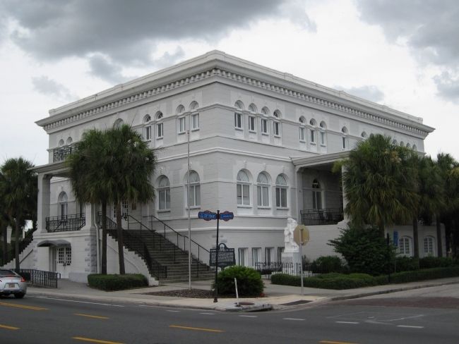
On North Nebraska Avenue at East 11th Avenue, on the right when traveling north on North Nebraska Avenue.
Organized in 1901, the German-American Club was one of the few non-latin ethnic clubs in Tampa. Club members laid the cornerstone for a building on the northeast corner of Nebraska Avenue and 11th Avenue on February 23, 1908, followed by a . . . — — Map (db m32372) HM
Near Carpenters Way 0.5 miles east of U.S. 98, on the left when traveling east.
The Carpenters' Home was the retirement home for members of the United Brotherhood of Carpenters and Joiners of America from 1929 to 1976. The Union completed the purchase of the 1,684 acre site in April 1924. Costing $632,393, the site included 594 . . . — — Map (db m100435) HM
On North 11th Street north of Reid Street, on the left when traveling north.
Asa Philip Randolph was one of the most influential political strategists and labor leaders of the 20th century
Asa Philip Randolph was born in Crescent City on April 15, 1889, the son of a Methodist minister. Both parents were supportive . . . — — Map (db m310947) HM
On Country Club Way at Groveland Avenue, on the left when traveling north on Country Club Way.
(Side 1)
In 1925, the Brotherhood of Locomotive Engineers (BLE), a labor union based in Cleveland, Ohio, purchased land to create the city of Venice. The BLE hired city planner John Nolen to complete the city design which he had already . . . — — Map (db m145507) HM
On Nassau Avenue north of Sorrento Street, on the right when traveling north.
John Nolen, world-renowned city planner from Philadelphia, created the overall design for the City of Venice. Venezia Park Subdivision helped illustrate Nolen's concept for a model city.
Dr. Fred Albee, early developer, commissioned Nolen's . . . — — Map (db m32558) HM
On Avenida Des Parques South at Menendez Street, on the right when traveling south on Avenida Des Parques South.
John Nolen, world renowned city planner, designed the City of Venice so residents could work and relax in harmony with nature and with each other. A central business area, outlying farms, open green spaces, and a wide variety of housing choices . . . — — Map (db m32702) HM
On Carroll Street Southeast south of Tennelle Street Southeast, on the right when traveling south.
Born in 1842, Jacob Elsas settled in Ohio in 1861 from Württemberg during a
wave of European-Jewish immigration. In 1865, Elsas moved to Cartersville,
Georgia, opening a trading store. Recognizing a shortage in manufactured
bags, Elsas relocated . . . — — Map (db m227418) HM
On Frederica Rd., on the left when traveling north.
Not far from this spot stood the "great tree" under which Charles Wesley had prayers and preached, March 14, 1736, the first Sunday after his arrival. There were about twenty people present, among whom was Mr. Oglethorpe. A year later, Georgia . . . — — Map (db m12370) HM
On W. Main Street, on the right when traveling east.
Plains Bank was organized in 1901 by R. S. Oliver, who served as president. W. L. Thomas, vice president, and C. C. Lunsford as cashier. The Plains Bank belonged to a chain of eighty three banks operated by Banker's Trust Company of Atlanta. The . . . — — Map (db m73060) HM
On Office Road north of Kapalua Drive, on the right when traveling north.
Built in 1929 by pineapple plantation carpenters, the company store was once the central gathering place for the village residents. It was here that plantation workers brought most of their supplies, caught up on the news of the day and read . . . — — Map (db m292906) HM
On West Jefferson Street at North Capitol Boulevard, on the left when traveling west on West Jefferson Street.
When in 1899 organized lawlessness challenged the power of Idaho, he upheld the dignity of the state, enforced its authority and restored
law and order within its boundaries, for which he was assassinated in 1905.
“Rugged in body, . . . — — Map (db m128543) HM
On East College Avenue at South First Street, on the right when traveling west on East College Avenue.
During W.W. I, St. Maries was a hotbed of International Workers of America (I.W.W.) unionizing activities. In December 1917, Sheriff E. Noland raided their headquarters near here and arrested secretary William Nelson for advocating sabotage. . . . — — Map (db m122104) HM
Near Main Street near South 7th Avenue, on the right when traveling west.
Second generation Hollanders, the 10 Steunenberg children (6 boys, 4 girls) lived their formative years in Knoxville, Iowa. A.K. (Albert Keppel) Steunenberg, answering an advertisement for a printer, came to Caldwell in the late 1880's. He called . . . — — Map (db m110215) HM
On Custer Motorway Adventure Road - Yankee Fork Road, on the right when traveling west.
The Miners' Union Hall served as a social center, as well as professional meeting hall. At its height, the Union boasted 200 members consisting of miners and businessmen. In many ways it was a fraternal organization not only for the miners, but also . . . — — Map (db m109900) HM
On Burke Canyon Creek Road (State Highway 4) near Yellow Dog Road, on the right when traveling east.
During a gun war that broke out between company and union miners here, several boxes of dynamite were exploded shattering a four-story mill, July 11 1892
Overwhelmed by union miners, company managers surrendered. Six fatalities -- half from . . . — — Map (db m122820) HM
On Washington Avenue (U.S. 51) south of 17th Street, on the right when traveling south.
President William Jefferson Clinton, 42nd President of The United States accompanied by his wife, Hillary and Vice President and Mrs. Albert Gore, Jr. spoke to a crowd of over 6000 in Cairo, Illinois at The Cairo Public Library on Friday, August 30, . . . — — Map (db m161195) HM
On Jefferson Street at Shoal Creek Avenue, on the right when traveling west on Jefferson Street.
United Mine Workers of America (UMWA) president and Congress of Industrial Organization (CIO) founder John L. Lewis (1880-1969) came to Panama, Illinois, from Iowa with his family in 1908 to work in the mines; within one year he was president to . . . — — Map (db m186233) HM
On West Cemetery Road east of Calvin Avenue, on the right when traveling east.
(front:)
"The public does not understand, and I think never will. That almost spiritual fealty that exists between men who go down into the dangers of the mine and work together. That fealty of understanding and brotherhood that exists . . . — — Map (db m186238) HM
On Main Street (State Highway 89), on the right when traveling south.
Just north of town are remnants of the Cherry Coal Mine, where 259 miners lost their lives in one of the worst mine disasters in United States history.
The St. Paul Coal Company began mining coal at Cherry in 1905 and by 1909 was mining . . . — — Map (db m308284) HM
On West Dakota Street (U.S. 6) just east of North Strong Avenue, on the right when traveling east.
Pioneer resident of Spring Valley. Achieved national prominence in the settlement of the Pennsylvania Anthracite Miners Strike in 1902 with the co-operation of President Theodore Roosevelt. President of United Mine Workers, 1889-1908. Author of . . . — — Map (db m308286) HM
On South Spaulding Street at East Caroline Street, on the right when traveling north on South Spaulding Street.
Pioneer resident of Spring Valley. Achieved national prominence in the settlement of the Pennsylvania anthracite miners strike in 1902 with the co-operation of President Theodore Roosevelt. President of United Mine Workers, 1889-1908. Author of . . . — — Map (db m308287) HM
On Old Western Avenue at Broadway Street on Old Western Avenue.
The original two-story part of this building was designed in 1915 by Chicago architect Douglas S. Pentecost for Henry Heimbach's Broadway Grocery & Market, a business that started across the street at what was originally 80 Western Avenue before our . . . — — Map (db m274345) HM
On West Exchange Avenue east of South Peoria Street, on the left when traveling west.
In memory of Leslie F. Orear (1911-2014), co-founder and first president of the Illinois Labor History Society (1969-2005).
Les walked through this gate along with thousands of stockyard workers. He helped to secure their rights through . . . — — Map (db m244161) HM
On West Exchange Avenue east of South Peoria Street, on the left when traveling east.
The Union Stock Yard and Transit Company, Chicago's legendary livestock market and slaughterhouse, opened at this site on Christmas Day, 1865. Here, 320 acres of swampland lying between Pershing Avenue, Halsted Street, 47th Street, and Ashland . . . — — Map (db m244189) HM
On 35th Street near Shields Avenue, on the right when traveling east.
This magnificent ball park was built all union under an historic project labor agreement and stands in tribute to the vision and unprecedented cooperation of those who crafted the agreement and to the many tradesmen and tradeswomen whose skill . . . — — Map (db m235429) HM
On 35th Street west of South Michigan Avenue, on the right when traveling east.
[Plaque on the front:]
In the name of the people of Illinois, I command peace
[Plaque on the rear:]
Chicago police attacked at the Haymarket
May 4, 1886
Eight officers killed
Mathias J. Degan • John J. Barrett • George F. Miller • . . . — — Map (db m270274) HM
On South Avenue O at East 117th Street, on the right when traveling north on South Avenue O.
Ed Blaszak, a local resident and employee of Republic Steel, designed the sculpture in 1981. His work conveys the interrelationship between the once towering steel industry, seen here in the 6 tall bars, and the people of Chicago's Southeast side, . . . — — Map (db m305968) HM
On South Avenue O near East 117th Street, on the right when traveling north.
In memory of
Hilding Anderson •
Alfred Causey •
Leo Francisco •
Earl Handley •
Otis Jones •
Sam Popovich •
Kenneth W. Reed •
Anthony Tagliori •
Lee Tisdale •
Joseph Rothmund
Martyrs—Heroes—Unionists
Shot down May 30, . . . — — Map (db m305958) HM
On South Avenue O at East 117th Street, on the right when traveling north on South Avenue O.
In memory of
Hilding Anderson •
Alfred Causey •
Leo Francisco •
Earl Handley •
Otis Jones •
Sam Popovich •
Kenneth W. Reed •
Anthony Tagliori •
Lee Tisdale •
Joseph Rothmund
Martyrs—Heroes—Unionists
Shot down May . . . — — Map (db m305964) HM
On East 117th Street near South Avenue O, on the right when traveling west.
This area, which was prairie land in 1937, was the site of the Memorial Day Massacre on May 30, 1937. On that day, about 1500 striking steelworkers, their families, and supporters marched near the entrance of Republic Steel at 118th and Burley . . . — — Map (db m305977) HM
On South Avenue O at East 117th Street, on the right when traveling north on South Avenue O.
Long hours, low wages, and unfair policies prevailed as the Steel Workers Organizing Committee, or SWOC, reached out to workers in 1936. While US Steel, the industry giant, signed a contract with SWOC in March 1937, other smaller companies or . . . — — Map (db m305972) HM
On 25th Street at Karlov Avenue, on the left when traveling west on 25th Street.
Rudy Lozano's short life was characterized by passionate community activism. He strove to empower workers and forge coalitions among Latinos, African Americans, and other minorities.
Lozano's activism began at a young age. While a student at . . . — — Map (db m237840) HM
George Pullman established his reputation in Chicago in 1859 by inventing a way to raise buildings to the new street level required for installation of a sewer system.
In 1863, he began converting railroad passenger cars into luxury sleeping . . . — — Map (db m99944) HM
On Mohawk Street north of Wisconsin Street, on the left when traveling north.
Albert Parsons was raised in Texas by his brother, Confederate General William Parsons. After the Civil War he became a radical Republican, and was appointed a state official during Reconstruction. The target of hostility from white Southerners, . . . — — Map (db m261151) HM
On South Cottage Grove Avenue north of East 11th Street, on the right when traveling north.
The Pullman Company symbolized America's pursuit of power and progress after the Civil War.
In the aftermath of an 1877 railroad workers' strike, the Pullman Palace Car Company represented growing corporate power. Talented architects and . . . — — Map (db m295804) HM
As machines replaced human labor, workers' jobs and lives changed.
In 1882, Pullman mechanical engineer Norman W. Robinson invented a new transfer table to move railroad cars. A small steam locomotive rolled a table that carried a railroad . . . — — Map (db m295726) HM
Behind the Pullman Car Works' elegant front, the car shops to the rear imposed unforgiving industrial discipline.
Skilled immigrants filled many of the early jobs at Pullman's Chicago shops. Men labored in cavernous spaces as machines . . . — — Map (db m295783) HM
On South Forrestville Avenue west of South St. Lawrence Avenue, on the right when traveling west.
The town of Pullman was one of the first and most important planned industrial communities in America. George Mortimer Pullman believed that beautiful surroundings would have "a refining influence" on workers. He directed architect Solon Spencer . . . — — Map (db m296250) HM
George Pullman believed that an orderly, attractive, company-owned town would uplift working people and develop wealth.
George Pullman believed that an efficient, profitable industrial enterprise required skilled workers who lived orderly, . . . — — Map (db m295785) HM
Near East 111th Street at South St. Lawrence Avenue, on the right when traveling west.
The routes walked by Pullman workers symbolized social rank, personal power, and rights as Americans.
In the 1880s, Pullman workers walked at sunrise into the largest car-building complex in the United States. Inside the gates, they walked . . . — — Map (db m296369) HM
This reconstructed guardhouse and gate mark the original main entrance for Pullman shop workers.
Completed in 1881, the Pullman Palace Car Works was encircled only by low walls and shrubs. Sometime between 1885 and 1887, perhaps in response . . . — — Map (db m295776) HM
The Pullman Company, founded by industrialist George Pullman, built world-famous railroad cars here from 1881 until 1968.
The Pullman Palace Car Company's signature product was the sleeping car, a luxurious fast-moving full-service "palace" . . . — — Map (db m295682) HM
On South Cottage Grove Avenue at East 111th Street, on the right when traveling north on South Cottage Grove Avenue.
The Pullman Company, founded by industrialist George Pullman, built world-famous railroad cars here from 1881 until 1968.
The Pullman Palace Car Company's signature product was the sleeping car, a luxurious fast-moving full-service "palace" . . . — — Map (db m296213) HM
Near East 111th Street west of South Champlain Avenue, on the right when traveling west.
The Pullman Company, founded by industrialist George Pullman, built world-famous railroad cars here from 1881 until 1968.
The Pullman Palace Car Company's signature product was the sleeping car, a luxurious fast-moving full-service "palace" . . . — — Map (db m296215) HM
On South Cottage Grove Avenue north of East 111th Street, on the right when traveling north.
The Pullman Company, founded by industrialist George Pullman, built world-famous railroad cars here from 1881 until 1968.
The Pullman Palace Car Company's signature product was the sleeping car, a luxurious fast-moving full-service . . . — — Map (db m296408) HM
On Erie Street east of State Street, on the left when traveling east.
Dedicated to the men and women of the United Brotherhood of Carpenters and Joiners of America
Our great union was formed here in Chicago in 1881 by Irish immigrant Peter J. McGuire, "Father of Labor Day" and leader in the fight for the . . . — — Map (db m262700) HM
On South Prairie Avenue south of East 18th Street, on the right when traveling south.
Chicago's three wealthiest men-Marshall Field, Philip Armour and George Pullman all resided on Prairie Avenue by the mid-1870s, firmly establishing it as Chicago's premier residential district. Leading architects were hired to design fashionable . . . — — Map (db m308707) HM
On North Desplaines Street north of Randolph Street, on the right.
On the 30th anniversary of the passing of Cesar Chavez, we commemorate this plaque to forever honor the lives and legacies of Brother Chavez and Sister Dolores Huerta.
They founded what would eventually become the United Farm Workers and . . . — — Map (db m270449) HM
On West Jackson Boulevard (Old U.S. 66) east of Kennedy Expressway (Interstate 90/94), on the left when traveling east.
A.B. Dick 1902-1949
Architect Alfred S. Alschuler, 1926
Hart, Schaffner & Marx/Hartmarx- 1949-1994
Haberdasher Square Lofts- 1995-
Architect - Pappageorge Haymes- Adaptive Re-use
Originally built in 1926 by architect Alfred S. . . . — — Map (db m294723) HM
On North Desplaines Street at West Couch Place, on the left when traveling south on North Desplaines Street.
(plaque 1)
On the evening of May 4th, 1886, a tragedy of international significance unfolded on this site in Chicago’s Haymarket produce district. An outdoor meeting had been hastily organized by anarchist activists to protest the violent . . . — — Map (db m47728) HM
On Joliet Road (Old U.S. 66) 0.2 miles west of La Grange Road (U.S. 12/20/45), on the right when traveling east.
Steam shovels are the earliest type of power shovel and were designed for lifting and moving large amounts of rock and soil. Steam shovels played a major role building roads and railroads in America during the 19th and early 20th century. While . . . — — Map (db m293634) HM
Has been designated a
National Historic Landmark
This monument represents the labor movements
struggle for workers rights and possesses National
significance in commemoration the history of
The United States of America
1997 . . . — — Map (db m115585) HM
Near Des Plaines Avenue 0.4 miles south of Eisenhower Expressway (Interstate 290), on the right when traveling south.
1887
The day will come when our silence will be more powerful than the voices you are throttling today.
[Plaque on the rear:]
These charges are of a personal character, and while they seem to be sustained by the record of the trial and the . . . — — Map (db m267562) HM
On New Avenue at Lockport Street, on the right when traveling east on New Avenue.
Legion Park was developed by Lemont Park District in 1997 in memory of three men killed and twenty-five men wounded here on May 4, 1885. State militia opened fire on striking quarry workers for failure to disperse and return to work by order of . . . — — Map (db m295548) HM
On New Avenue west of Main Street, on the right when traveling west.
Built circa 1858 of "Athens marble" as the Chicago & Alton Railroad station. The first train passed through Lemont on March 18, 1858. In 1865, the townspeople gathered here in silent tribute to Abraham Lincoln as his funeral train passed slowly . . . — — Map (db m295500) HM
Near Thatcher Avenue, on the right when traveling north.
This tablet was dedicated September 12, 1920 by Chicago Typographical Union No. 16 in honor of the following members of the organization who made the supreme sacrifice for their country in the World War, 1917-1919
Roy J. Broderson • Frank . . . — — Map (db m245875) WM
On East Division Street / Johnson Road (Illinois Route 113) 1 mile west of Interstate 55, on the right when traveling west.
The Diamond Mine of the Wilmington Coal Mining and Manufacturing Company, located near Braidwood on the Grundy-Will County line, was the site of a major mine disaster in Illinois.
The mine was on a marshy tract of land that had no natural . . . — — Map (db m6868) HM
Near Main Street (County Highway 15) at Mill Street, on the right when traveling north.
On July 19, 1932, unemployed workers marched toward the Marseilles
Dam, which was using out-of-state workers for a major project. As the
local workers reached the site, gunfire exploded from the dam site. 21
protesting workers were wounded and . . . — — Map (db m239352) HM
On Main Street (County Highway 15) at Mill Street, on the right when traveling north on Main Street.
In 1932 the national economic crisis of the Great Depression was still
growing. Workers had no legal right to organize unions, and had little
power individually to prevent lowering standards of living, but an
unemployed movement had formed. Near . . . — — Map (db m239351) HM
Near East Main Street east of West Street, on the right when traveling west.
One hundred years ago near this location, T.J. Wright and fellow Illinois Central Railroad conductors founded Division No. 1 Conductors Brotherhood later to become The Order of Railway Conductors and Brakemen, the second oldest railway labor . . . — — Map (db m209422) HM
On Montgomery Street at East Chestnut Street, on the right when traveling north on Montgomery Street.
Coal miners were the vanguard of the American Labor Movement and Illinois played a major role. In the 1890s tens of thousands of Illinois miners joined the United Mine Workers Union. But in succeeding decades the leadership of UMW President John L. . . . — — Map (db m184782) HM
On South Macoupin Street at East Pine Street, on the left when traveling south on South Macoupin Street.
Waves of European immigrants poured into
Gillespie in the 1880s to work its coal mines.
In the early 1900s, the Chicago and North Western Railroad opened four mines to fuel its locomotives. Locals knew each town by its mine number: . . . — — Map (db m185468) HM
On Mt. Olive Road at Old Reservoir Road, on the right when traveling south on Mt. Olive Road.
The Union Miners Cemetery in Mt. Olive, Illinois, is the only labor union-established and union-owned cemetery in the United States. It is the result of the Battle of Virden fought in Virden on October 12, 1898, when the Chicago-Virden Coal Company . . . — — Map (db m184803) HM
On North Dye Street at East Jackson Street, on the right when traveling south on North Dye Street.
Battle of Virden Monument State of Illinois Coal Office
UMWA District 12
Illinois AFL-CIO
City of Virden • John E Hein • John & Sondra Narmont • Wayne & Liz Joplin • John & Jeannie Alexander
In memory of Stephen & Luriel Narmont by . . . — — Map (db m195832) HM
On East Jackson Street at North Springfield Street ( Route 4), on the right when traveling east on East Jackson Street.
Miserable wages and working conditions in coal mines made conflict between miners and coal companies inevitable in the 1890s. The battle that erupted here immortalized Virden in the history of labor rights. On October 12, 1898, eight miners, four . . . — — Map (db m149885) HM
Coal Mine #4 opened in 1893 with a shaft that was 180 feet deep. The mine ceased operation in 1914.
In March of 1906 the United Mine Workers of America organized a national strike. Newspapers reported that half a million workmen and their . . . — — Map (db m196834) HM
On Cass Street at Johnson, on the left when traveling west on Cass Street.
The 1894 Pullman Strike and boycott of Pullman railcars led by the American Railway Union involved 250,000 workers in 27 states. It paralyzed much of the nation’s rail system and directly led to the establishment that year of a national Labor Day. . . . — — Map (db m118847) HM
Bloomington Fire Fighters organized as an original number of the International Association Fire Fighters on February 28th, 1918 as Local #49
• In 1921 Local #49 was disbanded due to the depression era antilabor sentiments in city governments . . . — — Map (db m163421) HM
Mary Harris was born in Cork, Ireland in 1837. Her family fled to Toronto during the famine. She moved to Memphis in 1860, married George Jones, an iron molder and proud union man. They had four children together.
Mary Jones moved to Chicago, . . . — — Map (db m156812) HM
On Interstate 55 at milepost 65, 10.8 miles south of Main Street (County Road 17).
Beneath us lies one of the nation's richest coal seams, formed 300 million years ago and covering two-thirds of Illinois. Coal made this state an industrial and economic powerhouse by the 1880s - it drove the machinery, heated the homes, smelted . . . — — Map (db m149886) HM
Illinois governor, 1897-1901, known for fair treatment of organized labor and African-Americans. Donations from both groups helped build this monument. — — Map (db m261763) HM
On South 11th Street at East Washington Street, on the right when traveling south on South 11th Street.
Near this site in 1917, union miner Henry Stephens walked a long route home "with headlamp and dinner bucket" at dusk in support of the streetcar workers' strike and boycott. He vowed to trek long miles in solidarity: "I'd live in the fields on . . . — — Map (db m281233) HM
On Dr. M R Lemons Boulevard at Bond Avenue, on the left when traveling west on Dr. M R Lemons Boulevard.
Dr. Leroy Bundy lived here. He was a community leader in 1917. He stood trial and was found guilty of causing the riot. He was sentenced to life in prison. He was later exonerated by the Illinois Supreme Court. — — Map (db m142225) HM
On South Main Street at East Keys Street, on the right when traveling south on South Main Street.
Dedicated to Coal Miners of Southern Illinois, August 12 1990.
Papa dug coal from deep in the hearth to earn a living. He dressed for work when everyone else went to bed. He wore faded denims and steel-toe shoes and he walked a mile to his job . . . — — Map (db m170688) HM
On North Hazel Street south of Cherry Street, on the right when traveling south.
Mourn for Fight for
the Dead the Living
Remember Vermilion County Workers
Killed on the Job
Left Column of Names
David Farnsworth - Danville PBPA •
Charles Deck - UAW # 579 •
David . . . — — Map (db m10556) HM
On North State Street at East Moses Avenue, on the right when traveling north on North State Street.
They made this community the melting pot of nations and proved that men of all nationalities and creeds can work and live together.
"To the men who went to work below allowing the top to build and grow giving their labors in brawn and sweat . . . — — Map (db m11393) HM
On Kankakee Road at Route 53, on the right when traveling north on Kankakee Road.
In 1864, farmer Thomas Byron dug a well and struck "black diamonds" - coal. The next year, Scottish miner James Braidwood sank the first shaft. Towns like Braidwood, Coal City, Carbon Hill, Diamond, and Godley sprang up. These villages were home . . . — — Map (db m157068) HM
(front:)
In recognition of the men who lost their lives in the conflict of June 21 & 22, 1922. A time of labor unrest and lawlessness which still stands as the largest loss of life due to a labor dispute in the country. A tragedy known as . . . — — Map (db m216308) HM
On Forest Avenue (Indiana Route 59) at East National Avenue (U.S. 40), on the right when traveling north on Forest Avenue.
Jimmy Hoffa was born in Brazil, Indiana in 1913. His family struggled with poverty, inspiring him to become an organized labor leader during the Great Depression. He became active in the International Brotherhood of Teamsters in the 1930s and served . . . — — Map (db m238479) HM
On North Main Street (Indiana Route 167) at Highland Avenue, on the right when traveling north on North Main Street.
This memorial erected by the American Flint Class Workers' Union of North America, and Local Union No.107 of Dunkirk, Indiana, to commemorate the life work of their First Secretary Benjamin E. Rubrecht, who remained an active member from the . . . — — Map (db m215081) HM
On West Washington Street just west of Meridian Street, on the right when traveling west.
Side A:Bowen-Merrill FireOn March 17, 1890 the Bowen-Merrill Company stationery and book store at 16-18 West Washington Street caught fire. Eighty-six firemen fought the blaze. The wood framed roof and floors collapsed, dropping many . . . — — Map (db m41185) HM
On South 7th Avenue west of Ohio River Scenic Byway, on the left when traveling west.
Mary Harris “Mother” Jones. Irish-born activist Mary "Mother" Jones organized workers across the U.S., demanding fair wages and safe working conditions. In Evansville, she rallied striking textile workers in 1901. She returned to Indiana . . . — — Map (db m289911) HM
1906 - - - - - 1992
President, Brotherhood of Railroad Trainmen
1963 - 1969
President, United Transportation Union
1969 - 1972
Contributing six decades to the Rail Labor Movement, Charles Luna began working as a Yard . . . — — Map (db m58537) HM
On North 8th Street south of Spruce Street, on the left when traveling south.
Debs (1855-1926) was leading pioneer in industrial unionism, social reformer, and peace advocate.
Founded American Railway Union, 1893; cofounded American Socialist Party, 1900; and ran five times for United States Presidency.
Home built in . . . — — Map (db m8928) HM
1919 - - - - - 1981
President, the American Federation of State,
County and Municipal Employees (AFSCME),
1964 - 1981
As president of AFSCME, Jerry Wurf was responsible for the union’s growth from 240,000 to one million . . . — — Map (db m58579) HM
President
Communications Workers of America
1938 - 1974
Joseph Beirne helped found the CWA in 1938, and served as President until 1974, helping develop CWA into the largest communications union in the Nation.
In 1949, when . . . — — Map (db m58536) HM
1905 - - - - - 1966
Co-Founder and First International President of
Transport Workers Union of America, AFL-CIO
(1934–1966)
1934 - - - Elected President of Transport Workers.
Organizing Subway, Bus and other Transit . . . — — Map (db m58581) HM
Field Organizer, United Mine Workers of America
“The most dangerous woman in America”
A teacher and seamstress, Mary Harris “Mother” Jones began her crusade for workers’ rights with the Knights of Labor in the 1870's. . . . — — Map (db m58469) HM
1849 - - - - - 1893
President
United Association of Journeyman and
Apprentices of the Plumbing and
Pipefitting Industry of the
United States and Canada
1889 - 1892
A plumber born in Boston, Massachusetts, Patrick J. . . . — — Map (db m58540) HM
1852 – 1906
Founder and General Secretary
United Brotherhood of Carpenters
and Joiners of America
1881 – 1901
Father of Labor Day
Peter J. McGuire was founder of the United Brotherhood of Carpenters . . . — — Map (db m58495) HM
1886 - - - - - 1952
President
United Steelworkers of America
1936 - 1952
Congress of Industrial Organization
1940 - 1952
Philip Murray went into the coal mines as a boy of 16. By 1916 he had risen through the ranks of . . . — — Map (db m58560) HM
1850 - - - - - 1924
Born in London, Jan. 27, 1850. Apprentice Shoemaker, 1860. U. S. Immigrant and member Cigarmakers Local 144, New York City, 1863. President, Local 144, 1876. Leader in convening Federation of Trades and Labor Unions, . . . — — Map (db m58468) HM
1907 - - - - - 1970
“- - - - Whose memory is enshrined in the hearts of all of us.”
Born at Wheeling, W. Va. Sept. 1, 1907, the son of Valentine and Anna Reuther. One of four brothers, the oldest Theodore and two younger . . . — — Map (db m58538) HM
814 entries matched your criteria. Entries 101 through 200 are listed above. ⊲ Previous 100 — Next 100 ⊳