Near County Road 63, 0.3 miles south of County Road 530, on the right when traveling south.
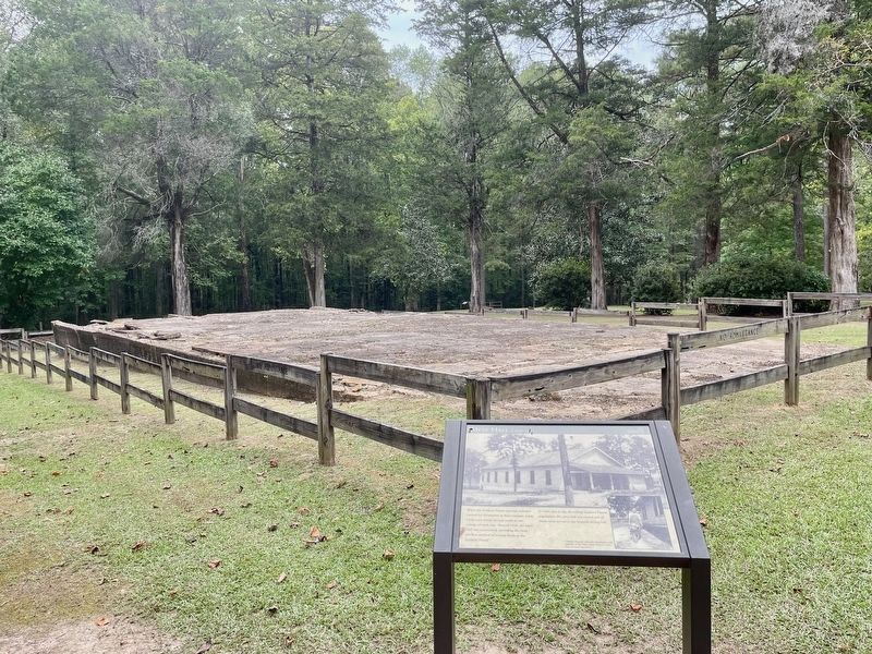
When the Soldiers' Home opened, veterans
cooked for themselves in their cottages. Later,
cooks were hired, serving meals in one
cottage of each row. Around 1920, the Mess
Hall was constructed, providing the most
efficient method of serving . . . — — Map (db m206693) HM
Near County Road 63, 0.2 miles south of County Road 530, on the right when traveling south.
The individual cottages at the Alabama
Confederate Soldiers' Home contrasted
with the large barracks found at many
other Civil War veterans homes across
the country during the early 1900's.
All nine cottages of the Soldiers' Home
had . . . — — Map (db m206689) HM
Near County Road 63, 0.3 miles south of County Road 530, on the right when traveling south.
The individual cottages at the Alabama
Confederate Soldiers' Home contrasted
with the large barracks found at many
other Civil War veterans homes across
the country during the early 1900's. The
cottages in this row were paid for by
private . . . — — Map (db m206798) HM
On Alabama Route 131 at County Road 79, on the right when traveling south on State Route 131.
Alpheus R. Chestnutt built this house in 1873 in what was once known as Chestnuttville but renamed Baker Hill in the mid-1880s. He also owned and operated a dry good mercantile on this property from 1870 until it burned in the 1880s. Upon his death . . . — — Map (db m197411) HM
Choccolocco Park is located on land that was farmed by the Caver,
Christian and Davis families from 1840 until the late twentieth
century. During the Great Depression, the farm was documented
by the Historic American Building Survey. The subjects . . . — — Map (db m145025) HM
On County Road 92, 0.3 miles east of County Road 585 when traveling east.
Constructed around 1875 by John Seaborn Watt for his bride, Emma Chastillette Williamson, this fine example of Victorian architecture was originally located near Yancey's Bend prior to the construction of Weiss Lake. The site was going to be . . . — — Map (db m137844) HM
On Cedar Bluff Road (State Road 283) north of West Main Street (Business U.S. 411), in the median.
The current courthouse is the fourth to be built on this site. The first courthouse, constructed of brick in 1849, burned in 1882. A second brick courthouse was built that year and it only lasted 13 years before it burned in 1895. The third brick . . . — — Map (db m114838) HM
On Jackson Drive east of Bay Springs Road, on the left when traveling east.
Hatcher School was created as a result of the dreams and sacrifices of the people of the community. Black children in Centre had to travel to Cedar Bluff to attend school. The State purchased land and citizens of the community provided funding and . . . — — Map (db m133323) HM
On South River Street south of 2nd Street, on the left when traveling south.
This house was built in 1846 by George Walden soon after the town of Centre was laid out. The house was occupied by Judge Wm. Lafayette Whitlock who was a lawyer, delegate to the 1861 Secession Convention and judge of the 12th judicial district. . . . — — Map (db m120047) HM
On East Main Street (Business U.S. 411) at Cedar Bluff Road, on the left when traveling east on East Main Street.
Jordan Big Store
has been placed on the
Alabama Register of
Landmarks & Heritage
by the Alabama
Historical Commission
August 10, 2017 — — Map (db m114746) HM
After the war broke out, wooden frame barracks were built by North and South at permanent installations such as forts, arsenals, coastal installations, and training camps. In winter, smaller barracks were constructed with available materials and man . . . — — Map (db m129426) HM
On County Road 63, 0.7 miles north of State Route 143, on the left when traveling north.
After the death of Jefferson Manly Falkner, Soldiers' Home founder in 1907, the Soldiers'
Home Board of Control commissioned this obelisk in his honor. The monument was erected in 1908 under the northeast corner of the veranda of Memorial Hall. . . . — — Map (db m129411) HM
On County Road 63, 0.6 miles north of State Route 143, on the left when traveling north.
This late nineteenth century building, originally Gray & Speer's store, was located less than a mile south near the South & North Railroad (later L&N and present day CSX). It was converted to a post office around 1906.
Veterans from the Alabama . . . — — Map (db m129333) HM
On South Jackson Street, on the right when traveling south.
Built by Judge John Gates Creagh, attorney, commissioner, county treasurer, judge of county orphans court and state legislator. It was originally located on lot 15 Court Street, facing the county court house, and was moved in the mid 1930's to . . . — — Map (db m47652) HM
On Mayton Drive, on the left when traveling south.
Built circa 1848 by Isham Kimbell on Lower Commerce Street. Given to city by Woodson family and moved
to this site in 1977 by Jackson Historical Commission, successors to Jackson Bi-Centennial Committee, with a grant from the M. W. Smith, Jr. . . . — — Map (db m39202) HM
Near Court Square (Road 31) at 2nd Avenue North, on the right when traveling south.
Clay County
Established Dec. 7, 1866
Boundaries of eastern Talladega County and western Randolph County were redrawn in 1866 to create the 58th county of Alabama. The name honors U. S. Senator Henry Clay of Kentucky. Historical place . . . — — Map (db m95095) HM
On W. 20th Street at W. 15th Street on W. 20th Street.
Center of Industry for new town of Sheffield. Five blast furnaces with 75 ft stacks build 1886~1895 1/2 mile west. Promoted by E. W. Cole and E. Ensley. Iron ore and limestone from Franklin Co., coke from Walker Co. and Virginia used. Hattie Ensley . . . — — Map (db m28428) HM
This congregation was organized in July 1823 as Concord Church, later known as Union Church, then as Tuscumbia Baptist. Jeremiah Burns was the first pastor. It began meeting at this site about 1845 in a plain wooden building. The New England-style . . . — — Map (db m28564) HM
On County Road 5, 1.2 miles north of County Road 30, on the right when traveling north.
This two and a half story structure with unusual lower front extension was the home of Dr. John Watkins. Dr. Watkins was one of the first and few physicians in this part of the Mississippi Territory. Before coming to Burnt Corn, he lived in . . . — — Map (db m81297) HM
On Alabama Route 22 at Jackson Street, on the right when traveling west on State Route 22.
Coosa County
Named for the river on its western border, Coosa County was created by the Alabama Legislature on December 18, 1832, from land ceded by the Creek Nation in the Treaty of Cusseta. The name is taken from the Native American word . . . — — Map (db m131716) HM
On East 3 Notch Street at 6th Avenue, on the right when traveling west on East 3 Notch Street.
Andalusia City Hall
Today, the Andalusia City Hall houses city government offices and is a host site for meetings and special events. Modern information, technology, and communications of city government mesh with the original . . . — — Map (db m94169) HM
On South 3 Notch Street at Dunson Street, on the right when traveling south on South 3 Notch Street.
History of the Library
In 1913 the Study Club of Andalusia was organized to establish a library for Andalusia. Led by founder Miss Ethel Darling the club held a book shower
resulting in $5.50 and 15 books which became the embryo of the . . . — — Map (db m129389) HM
On West 3rd Street (Alabama Route 15) near Glenwood Avenue, on the right when traveling east.
Crenshaw County was established from five existing counties in 1866. The first courthouse and county seat were originally in Rutledge. The county seat moved to its present location after the 1893 election. The first courthouse at this location . . . — — Map (db m183474) HM
On Glenwood Avenue at East 4th Street, on the right when traveling north on Glenwood Avenue.
In the late 1800s, Benjamin R. Bricken,
Crenshaw County's first attorney-at-law, built
the Bricken Building, a landmark in the field
of law in this county. Between 1893 and 1933,
the Bricken Law Firm occupied the building
Then, Ben H. Lightfoot . . . — — Map (db m163730) HM
On 3rd Street Northeast (U.S. 278E) at 6th Avenue Northeast, on the left when traveling east on 3rd Street Northeast.
The Betz Addition Historic District, also known as “Quality Hill”, lies to the north of Highway 278 East and is named in honor of Cullman’s first mayor, Fred Betz. The district is listed on the Alabama Register of Landmarks and Heritage. . . . — — Map (db m33839) HM
On Arnold Street, on the right when traveling east.
The Louisville and Nashville Railroad Company completed building this Mission Style depot in 1913. When the tracks were laid below ground level, it replaced Cullman's first station located on First Avenue at Third Street, SW.
Passenger service . . . — — Map (db m29975) HM
On Vine Street at 1st Street North, on the right when traveling north on Vine Street.
Prior to 1905, workmen in search of
salvageable bricks dismantled the old
Dallas County Courthouse (pictured
here). The grassy mound before you
contains the damaged bricks the
workmen left behind.
Cahawba was the county seat from . . . — — Map (db m112559) HM
On Capitol Avenue at Vine Street, on the right when traveling east on Capitol Avenue.
Alabama's first statehouse stood on this lot, but no drawing by a person who actually saw it has been found. It was built in 1819 and destroyed in 1833, before the invention of photography. There are many drawings of the statehouse, but all are pure . . . — — Map (db m75908) HM
On Oak Street north of Fifth North Street, on the left when traveling north. Reported permanently removed.
Two story brick slave quarters like the
one before you were not typical, but they
could be found in wealthy towns like
Cahawba.
Stephen Barker built these quarters in
1860 on the northern edge of town.
As you can see in the . . . — — Map (db m112472) HM
On Vine Street, on the left when traveling south. Reported permanently removed.
St. Luke's was consecrated in 1854. It was an outstanding example of the Gothic Revival style, popular at the time. The contractor closely followed designs in a widely circulated book, Rural Architecture, published in 1852 by the celebrated . . . — — Map (db m75922) HM
On Vine Street at Capitol Street, on the right when traveling north on Vine Street. Reported damaged.
Cahawba's homes were spread over an
entire square mile, many with yards of
one or two acres. That was not the case
here on Vine Street. Offices, stores and
hotels were tightly packed along this
main street. The steamboat landings on
the . . . — — Map (db m112560) HM
This house, the Fambro / Arthur home,
takes its name from two of its owners.
One was a judge, the other was a former
slave.
The Fambro Family
A. Judge W. W. Fambro built this house
in the early 1840s. He may have created . . . — — Map (db m112451) HM
Near Alabama Avenue near Lauderdale Street, on the right when traveling east.
Entered on the National Register of Historic Places March 26, 1976 Federal Building U.S. Courthouse Selma, Alabama James Knox Taylor Architect 1909 This property significantly contributes to the nation’s cultural heritage . . . — — Map (db m131992) HM
On Union Street at Alabama Avenue on Union Street.
Central Masonic Institute of Alabama acquired property 1847 and erected building. Confederate Hospital during War Between the States. Dallas County Courthouse (1866-1901) on removal of County Seat from Cahaba. Presbyterian High School for Boys in . . . — — Map (db m37656) HM
On Church Street at Parkman Avenue, on the right when traveling south on Church Street.
This Greek Revival house was built circa 1850 by Thomas Helm Lee, master builder and owner of early Selma lumber yard. Born in Kentucky, he was the son of Miller Lee of Buckingham County, Virginia and married Mary Jane Blanks of Cahaba in 1839. He . . . — — Map (db m37674) HM
On Lauderdale Street, on the right when traveling north.
Built c. 1859 by Henry H. Ware, this house exemplifies the picturesque eclecticism which dominated Alabama architecture after 1850. It mixes elements of the older neoclassicism with the newer Victorian trends.
Prominent owners through the years . . . — — Map (db m37675) HM
On Mabry Street south of Jeff Davis Avenue, on the right when traveling south.
This Italianate style cottage was built in 1859 by C. B. and Martha Todd White. Mrs. White, half sister of Mrs. Abraham Lincoln, was an outspoken Southern patriot, who subjected the Lincolns to severe criticism, when the Northern press accused her . . . — — Map (db m38274) HM
Near South Main Street south of West School Street, on the left when traveling north.
Built in Wilcox County, Alabama
1845
this ancestral home of the Watson
family was donated to
Leadership Atmore in 1999.
In memory of
Rupert Basil Watson
1905 – 1981 — — Map (db m130677) HM
On Belleville Avenue at Court Street, on the right when traveling south on Belleville Avenue.
The Leigh Place
The First Escambia County Courthouse
in Brewton
Used as the County Seat from 1885 to 1890. After
various other uses, remodeled as an office in 1969. — — Map (db m84392) HM
On St. Joseph Avenue (U.S. 31) at Mildred Street (U.S. 29), on the right when traveling north on St. Joseph Avenue.
Truly an Escambia County landmark, Robbins and McGowin Co. organized in March 1897 with the consolidation of the J. I. Robbins and J. G. McGowin Stores, the millinery of Miss L. A. Cunningham, the Blacksher-Miller Commissary, and the J. E. Finlay . . . — — Map (db m130673) HM
On Misella Street at Lamosa Street, on the right when traveling south on Misella Street.
Martin Lindsey bought the Pollard Mill later known as the Lindsey Mill Company. Several hundred employees worked at the Mill during the early 1900s, among them Joe Douglas, head of the woodlands, and Percy Watson, accounting. Mr. Lindsey handled the . . . — — Map (db m84386) HM
On 6th Avenue at 4th Street NW, on the right when traveling north on 6th Avenue.
In 1851 twelve Methodists met in Newton (later Attalla) to plan a Methodist Episcopal Church. A crude log building on North Fifth Street served as the first church. In 1861 and again in 1882 the church relocated on Fifth to accommodate the growing . . . — — Map (db m83731) HM
On South 1st Street south of Walnut Street, on the right when traveling north.
Through the efforts of local citizens, Benny Dean and Floyd Beddingfield, the City of Gadsden obtained this facility from American Legion Post Number 5 in 1985. Built in 1935, the amphitheater seats 1600 persons. Designed by local architect, Paul W. . . . — — Map (db m83736) HM
On South 1st Street, on the right when traveling north.
Built of local sandstone in 1935 on land obtained from the American Legion Post No. 5 this municipal amphitheatre seating about 1600 was constructed for staging theatrical and sporting events. Gadsden architect Paul W. Hofferbert designed the . . . — — Map (db m39140) HM
On Broad Street at North 5th Street, on the right when traveling west on Broad Street.
This Italianate brick commercial structure with a cast-iron storefront on the first floor is significant for its 24 year association with Gadsden’s principal newspaper. It was constructed in 1904 to house The Gadsden Times-News, which was . . . — — Map (db m39217) HM
On Chestnut Street at South 9th Street, on the right when traveling east on Chestnut Street.
Built in 1886 for Edward Tracy Hollingsworth, a prominent merchant and banker, this two-story Victorian - style house with mansard roof is one of the few surviving examples of late-nineteenth century architecture in Gadsden. The original complex . . . — — Map (db m39134) HM
On County Road 28, 2.5 miles east of State Route 95, on the right when traveling east.
Side 1
Reuben Hicklin Hall Log Home
Reuben Hicklin Hall (1812-1890) and Mary Ann Strange (1814-1872) moved to Henry County by ox wagon from Washington County, Georgia, in 1845. They built a log home just south of here with slave . . . — — Map (db m71821) HM
On Kirkland Street, on the right when traveling south.
This rare, dual front door, double pen Creole cottage was constructed circa 1840 on the military three-notch road, now Kirkland Street. It is the oldest remaining structure in Abbeville. Earliest known owner was Confederate Colonel William Calvin . . . — — Map (db m60754) HM
On County Road 47, 4.5 miles south of State Route 10, on the right when traveling south.
Side 1
“The Mansion” was built in the 1830's on this site by Colonel James Bennett and his wife, Harriet M. Grace. Tradition maintains that it was the only three story antebellum home in the Chattahoochee Valley. The top . . . — — Map (db m83759) HM
On North Main Street (Alabama Route 95) at Clark Street, on the right when traveling south on North Main Street.
This house, also known as Travelers Rest, was completed in 1890 by William Henry Purcell (1845-1910) a prominent Columbia businessman and politician. Purcell had many business interests including a steamboat landing on the Chattahoochee River. This . . . — — Map (db m73370) HM
On Museum Avenue north of East Main Street (U.S. 84), on the right when traveling north.
Municipal
Light & Water Plant
has been placed on the
National Register
of Historic Places
by the United States
Department of the Interior
1991 — — Map (db m115030) HM
Entered on the National Register
of Historic Places
December 31, 1974
Federal Building
U.S. Courthouse
Dothan, Alabama
James Knox Taylor Architect 1909
This property significantly contributes to the Nation's Cultural Heritage . . . — — Map (db m83781) HM
On North Foster Street at North Foster Street & E Troy St, on the right when traveling north on North Foster Street.
This District encompasses the old downtown commercial center of Dothan and is characterized by a high concentration of closely spaced commercial and warehouse structures. The buildings in the District span the period of Dothan’s early growth from . . . — — Map (db m220453) HM
Side 1
This quaint turn of the century farmhouse originally stood on an 80 acre farm, located 2 miles west of the Houston County Courthouse. The house was built by Bud Bush of heart pine lumber from the sawmill owned and operated by . . . — — Map (db m73378) HM
On Eastern Valley Road south of Elrie Boulevard, on the right when traveling south.
A cotton plantation house
circa 1840, with about 2,000 acres.
Built by Thomas McAdory, Jr.,
the pioneer architecture was the
dog-trot style built of numbered
hand-hewn logs and wooden pegs.
Born here: Robert McAdory,
first mayor of Bessemer . . . — — Map (db m215904) HM
On Rhodes Circle, on the right when traveling west.
The house was built c. 1908 for Adolph B. Loveman, a Hungarian immigrant who in 1887 founded the dry goods business that evolved into one of Birmingham’s signature retail establishments, Loveman, Joseph & Loeb. Its English-style neighbor to the . . . — — Map (db m83800) HM
Near 3rd Avenue North near Richard Arrington Jr, Blvd North.
To Be Opened March 1, 2022
Dedicated at the construction completion March 1, 2002
Project Team
Owners - BLH Group, LLC
Brookmont Investors II, LLC
Spire Holdings, LLC
Developer - Brookmont Realty Group, LLC
General . . . — — Map (db m27010) HM
On Richard Arrington Jr. Boulevard North at 2nd Avenue North, on the left when traveling north on Richard Arrington Jr. Boulevard North.
The two commercial buildings on this corner lot are some of the earliest surviving business houses in Birmingham. The Dewberry building appeared on the corner about 1881, and it housed the first and longest surviving drug store in the city, starting . . . — — Map (db m36740) HM
Near 32nd Street North at 2nd Avenue North, on the left when traveling north.
The Duncan House was build in 1906 as a home place for James and Lelia Duncan and their eight children in what is now Tarrant City, Alabama. Duncan worked throughout his life in the nearby shops and yards of the L&N Railroad (know CSXI) as water . . . — — Map (db m86613) HM
On 20th Street South at 11th Avenue South, on the right when traveling north on 20th Street South.
This neighborhood developed in the 1880s as one of Birmingham's first streetcar suburbs. It was the Town of Highlands from 1887 to 1893, when it became part of the City of Birmingham. The heart of the neighborhood was Five Points Circle, a major . . . — — Map (db m83829) HM
Territorial legislature designated home of Maj. Moses Kelly (in Jones Valley) as site of first court in this area of Alabama, 1818.
After creation of Jefferson County, 1819, court held at Carrollsville (Powderly) until county seat established . . . — — Map (db m25743) HM
On 19th Street North at 3rd Avenue North, on the right when traveling north on 19th Street North.
Built in 1937, Birmingham’s S. H. Kress Five-and-Ten Cent Store was the second completed of the three great mercantile buildings on this intersection. Its construction reflected Kress’s confidence in Birmingham’s economy and marked a break by its . . . — — Map (db m38557) HM
On 3rd Avenue North, on the right when traveling east.
Built by the Publix Theater division of Paramount Studios. This movie palace opened on December 26th, 1927. The theatre, in Spanish / Moorish design by Graven and Mayger of Chicago, seated 2500 in a five story, three-tiered auditorium. Paramount's . . . — — Map (db m27337) HM
On 2nd Avenue North, on the left when traveling west.
This row of buildings from 2009 to 2017 Second Avenue dates from the early years of the 20th century and has undergone a variety of changes and modernizations over the years. Originally part of a larger building that burned in 1944 (now the site of . . . — — Map (db m38563) HM
Birmingham’s first library was organized in 1886 and in 1891 became a subscription library for the general public. In 1908 the Birmingham Public Library Association established a free public library, and the City created an independent Library Board . . . — — Map (db m83856) HM
Near Richard Arrington Jr Boulevard North at Park Place, on the right when traveling east.
The Tutwiler Hotel
In 1913, George Gordon Crawford, President of Tennessee Coal, Iron and Railroad Company, complained to Robert Jemison Jr., that when friends and officers from U.S. Steel came to town they had no decent place to stay. . . . — — Map (db m99317) HM
Gen. James H. Wilson, USA, having crossed the Tennessee River with a large force of well equipped cavalry, grouped them here at Elyton.
Their mission: to destroy Alabama's economic facilities for supporting the War.
From these headquarters he . . . — — Map (db m24358) HM
On Highland Avenue, on the right when traveling east.
Built during the Roaring Twenties, the Altamont
Apartments broke ground in 1924 and were
completed in 1925. Designed by architect Jacob E.
Sallte as an apartment/hotel, they were built
to attract affluent businessmen who desired
luxury, . . . — — Map (db m216069) HM
On Park Avenue, on the right when traveling north.
Summit/Hale Sps., a one-room school, opened on the mountain in 1898. It moved to this site and was named Bluff Park Elementary School with 50 students and funded with community support in 1923. From two-rooms, it expanded to 32 classrooms in 1988. . . . — — Map (db m28486) HM
On Montevallo Road, on the right when traveling east.
Jonathan Bass was born January 30, 1837, in Jefferson County. His father arrived in Jefferson County in 1816, and Jonathan was a life-long resident. Although the Bass House was under construction as early as 1863, Jonathan left the farm to join the . . . — — Map (db m24697) HM
On Office Park Circle, 0.1 miles west of Cahaba Road, on the right when traveling west.
In 1955, Ervin Jackson and Newman H. Waters developed the first office park in the United States.
Since 1871 office buildings had been located in downtown Birmingham so the concept of thousands of workers coming to a suburban work-place was a . . . — — Map (db m83252) HM
On Pinson Valley Parkway (Alabama Route 79), on the right when traveling south.
Front:
A pipe foundry was established in 1912 by the following founders, A. H. Ford, F. M. Jackson, E. E. Linthicum, Charles Green and Charles Day. Originally the main office was located approximately 100 yards west of this building. The . . . — — Map (db m83928) HM
On Alabama Route 17 at Brown Street, on the right when traveling north on State Route 17.
Built in 1888, this was the first house constructed within the original city limits of Sulligent after incorporation. It was the family home of William W. and Tallulah Henson Ogden. One of the founders and chief promoters of Sulligent. Mr. Ogden was . . . — — Map (db m96471) HM
On Lee Highway (U.S. 72) 0.7 miles west of County Road 583, on the left when traveling west.
Daniel White, native of North Carolina, purchased land here in 1818, a year before Alabama became a state. His home and stagecoach stop, "Wayside Inn" was a large two~ story log house located on the North side of the highway from this site. In 1834 . . . — — Map (db m29170) HM
On Lelia Avenue at Willingham Road on Lelia Avenue.
The land on which this district rests was part of the 1818 sale by the Cypress Land Company which established the City of Florence. During The Civil War Confederate soldiers constructed breastworks here for the defense of Florence. House . . . — — Map (db m35235) HM
On Hermitage Drive at North Court Street, on the right when traveling north on Hermitage Drive.
This "double- pile cottage" is a rare Alabama example of Tidewater architecture that originated along the Southern seaboard during the colonial period. This house was built in 1833 by Thomas J. Crowe, proprietor of the early National Hotel in . . . — — Map (db m83962) HM
On E. Mobile St. close to Wood Ave., on the right when traveling east.
The Presbyterians organized the first church in Florence and purchased this property from the Cypress Land Company in 1818. A sanctuary was erected here in 1824. James L. Sloss, an early Alabama Territory missionary, was installed as the church's . . . — — Map (db m28955) HM
On North Pine Street south of West Tuscaloosa Street, on the right when traveling south.
(side 1)
The Karsner-Kennedy House is significant because of its architectural characteristics. Benjamin F. Karsner (1800-1897) of Maryland married Sarah McCarter of Virginia in 1827. He was a prominent figure in Florence and at times he . . . — — Map (db m84026) HM
On North Wood Avenue north of East Irvine Avenue, on the right when traveling south.
The great engineering genius of the Panama Canal lived at this site from 1888 until 1907.
As a young lieutenant, Gothals was sent to Florence to speed up the work on the Muscle Shoals Canal Project which effectively by~passed the serious river . . . — — Map (db m84033) HM
On Hermitage Drive just north of North Seminary Street, on the right when traveling south.
Pope's Tavern Museum is housed in a building that dates back to the early 1800s. According to legend Christopher Cheatham built and operated a tavern on this site for Leroy Pope in 1811. This was seven years before the founding of Florence in . . . — — Map (db m66764) HM WM
On North Main Street north of East Tuscaloosa Street, on the right when traveling south.
Built in 1826 in the Spanish Revival architectural style, this is the first structure in Florence erected with a steel skeleton supporting the floors, walls and roof. The framework is strong enough to support two more stories than were actually . . . — — Map (db m35176) HM
Named for the O’Neal family which produced two Alabama governors and for seminary, the street on which the Synodical Female College was located, the Seminary-O’Neal Historic District was added to the National Register of Historic Places in 1995. . . . — — Map (db m84049) HM
On North Court Street at East Mobile Street on North Court Street.
Charles Morton Southall (1864-1952) constructed this Commercial Italianate style building in 1900 of the finest materials for his wholesale/retail drug business. The elegant interior by Charles Hester, New York City, contained the area's first . . . — — Map (db m35175) HM
On North Walnut Street near East Tuscaloosa Street.
Walnut Street began as a residential area in the national economic boom of the 1880s and 1890s and continued its development through the 1920s. Industries and businesses grew in Florence, the population of the city increased, and business and . . . — — Map (db m84158) HM
The Wesleyan Bell was manufactured by the C.S. Bell Company in Hillsboro, Ohio, it is made of alloy steel, has a diameter of 38 inches, and is 24 inches high (not including its yoke). The weight of the bell is 660 pounds. When 350- pounds mountings . . . — — Map (db m28881) HM
On Jefferson Street at Van Buren Street, on the right when traveling west on Jefferson Street.
Built about 1830 for merchant Joseph Trotter, this house was purchased in 1838 by John J. McMahon, a Virginia-born cotton factor who divided his time between Courtland and New Orleans. The house remained the home of McMahon's descendants for nearly . . . — — Map (db m84307) HM
On Wheeler Dam Road (State Highway 101) at County Road 269, on the right when traveling north on Wheeler Dam Road.
This mansion, located about one mile east, was placed on the National Register of Historic places 1 Oct 1974. Built by Turner Saunders (1782-1853) on property purchased 9 April 1833, the house may have an earlier construction date.
Revolutionary . . . — — Map (db m37281) HM
On Tichenor Avenue at North Gay Street, on the right when traveling east on Tichenor Avenue.
Side 1
In 1846, Auburn's founder, Judge John J. Harper deeded the property on this corner to Simeon Perry, as town agent for two of the earliest public schools in Auburn. A member of the settlement party, Perry laid out the original . . . — — Map (db m79948) HM
On East Magnolia Avenue at South Debardeleben Street, on the right when traveling east on East Magnolia Avenue.
Built by Auburn merchant A.L. Dillard in 1894, the home was once part of the old Scott Plantation. It was one of the first homes in Auburn to have an indoor bath and electricity. An unusual feature of the house is the gray stone, for which Dillard . . . — — Map (db m74445) HM
The Lane House, built in 1853 at the corner of Thach and College Street, was home to several Auburn University notables, E. T. Glenn, Treasurer, leased it in 1873. Gen. James H. Lane, Aide to Gen. Stonewall Jackson and Head of Engineering, purchased . . . — — Map (db m85165) HM
On South Debardeleben Street at East Magnolia Avenue, on the left when traveling south on South Debardeleben Street.
(Side 1)
Colonel Nathaniel J. Scott, from Harris County Georgia, built this house, which he called Pebble Hill, on 100 acres in 1847. With its pyramidal roof and symmetrical lines, the frame house reflects the Greek Revival . . . — — Map (db m74446) HM
On East Magnolia Avenue, 0.1 miles east of North Ross Street, on the right when traveling east.
Designed by William Dryden Baughman and built by Fred Burk in 1929, the house was not finished due to the Great Depression. Because of its two-story turret and French Norman Style, it became known as "The Castle." In 1949, the home was sold to . . . — — Map (db m74443) HM
Marker Front Thomas Bibb built this grand house in 1826 and named it "Belle Manor" (beautiful home), but local pronunciation altered it to "Belle Mina". The home which stayed in the Bibb family until 1940 was the seat of Bibb's large . . . — — Map (db m85424) HM
On Westside Street south of West Northside Street, on the right when traveling south.
This two-story brick structure, built in 1870, is an example of the Italianate Style. Many of these buildings no longer exist, being replaced by later growth in downtown districts. The Italianate Style is distinguished by the large upper story . . . — — Map (db m100193) HM
12449 entries matched your criteria. The first 100 are listed above. Next 100 ⊳