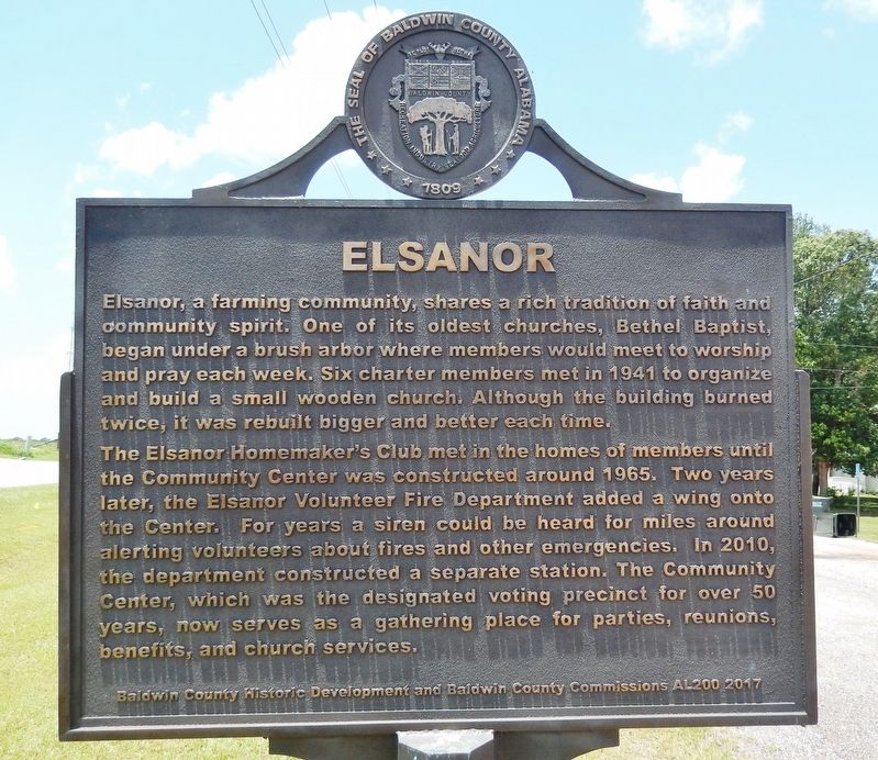
On U.S. 90 at Thelma Burke Road/Poplar Road, on the right when traveling west on U.S. 90.
This countryside along what is called the “Old Spanish Trail” between Mobile Bay and Pensacola was only sparsely settled in the early 1900’s. In 1909, F. X. Duchesneau and other French Canadians from North Dakota moved here to . . . — — Map (db m285990) HM
On 24 N Section Street at Fairhope Avenue, on the right when traveling north on 24 N Section Street.
Dedicated 2008
A gift to the people of Fairhope from
The Fairhope Single Tax Corporation
& the City of Fairhope
Dedicated April 5, 2008
The Front Section of this structure was carefully restored to reflect its original
use as Fairhope's . . . — — Map (db m128887) HM
On Alabama Route 59, on the left when traveling south.
1942, Benjamin DeWitt Cobb, more affectionately known as “B.D.”, was appointed as the lone police officer for the town of Foley. In 1943, another officer was hired and B.D. was appointed as the first Chief of Police. This marked the . . . — — Map (db m81581) HM
On Sand Valley Road 0.3 miles north of U.S. 231, on the left when traveling north.
Near this site once stood a school built for African American children erected in 1925 at a cost of $2,800. Funding for the two-classroom, wooden structure came from area residents, along with public funds and $700 from the philanthropic foundation . . . — — Map (db m282167) HM
Near Braggs Road (Alabama Route 263) 0.4 miles north of Sherling Lake Road (County Road 44), on the left when traveling north.
Commissioned and opened to the public in 1950, Sherling Lake is part of the Alabama Department of Conservation's efforts to construct public fishing lakes throughout Alabama in the 1940s. Greenville Chamber of Commerce President A.G. Johnson . . . — — Map (db m228690) HM
On County Road 63 0.7 miles north of State Route 143, on the left when traveling north.
On this site stood "Memorial Hall," the two story, log and shingle administrative and social center of the Alabama Confederate Soldiers' Home. Construction was partially financed by individuals from across the state who purchased "Memorial Logs" for . . . — — Map (db m129410) HM
I propose to create a Civilian Conservation Corps to be used in simple work…More important however, than the material gains will be the moral and spiritual value of such work.
–Franklin D. Roosevelt
On Oct. 29, 1929 the world changed as we know it. On that
ominous day, the stock market crashed and facilitated the U.S.
Great Depression. Many Americans were unemployed and
numerous families lost their homes to foreclosure. In 1933
President . . . — — Map (db m175325) HM
On Old Hwy 20 east of Morgan Drive, on the right when traveling east.
The town of Leighton was named in honor of the Reverend William Leigh, son and grandson of Revolutionary War veterans. He was born in Amelia County Virginia, Oct 4, 1790 and moved to Alabama about 1823. Leigh settled nearby at “Jeffers Cross . . . — — Map (db m278611) HM
Near Reservation Road 1 mile east of Route 133, on the left when traveling east.
In the early 1930s, which Wilson Dam serving as the starting point for the newly formed TVA and its river development plan, an era of new prosperity in the region began. TVA embarked on one of the largest U.S. hydropower construction programs . . . — — Map (db m106193) HM
On CCC Camp Road north of Reservation Rd, on the right when traveling west.
The Civilian Conservation Corps (CCC) was created as a public
work relief program during the Great Depression as part of Roosevelt's
New Deal. Congress passed legislation to create the agency in
March 1933, and by the time the CCC dissolved in . . . — — Map (db m280034) HM
The Civilian Conservation Corp (CCC) Park features a stone picnic pavilion constructed in 1935 as well as mature tree
growth, trails and a commanding view that overlooks the Tennessee River and Wilson Dam. Many of the trails along
the river bluff . . . — — Map (db m280037) HM
Wilson Dam
Potential floodwaters that surge downstream on the Tennessee River are collected in Wilson Lake. Then, through carefully controlled releases, the water is gradually sent through the dam. Releasing water through the dam serves . . . — — Map (db m124083)
Near Reservation Road 1 mile east of Route 133, on the left when traveling east.
Natural and Cultural Preservation
TVA is fully committed to protecting our natural and cultural resources. And nowhere is that more evident than right here at Wilson Dam.
Here, the 25-acre Old First quarters Small Wild Area showcases the . . . — — Map (db m106189)
The Tennessee River has its headwaters in the mountains of Tennessee, Virginia, North Carolina and Georgia. The main stream forms at Knoxville, where the Houston and the French Broad Rivers join. The valley, 41,000 square miles in area, receives . . . — — Map (db m280032) HM
Near Reservation road 1 mile east of Route 133, on the left when traveling east.
When the bombing of Pearl Harbor suddenly thrust the United States into World War II, President Roosevelt knew that industrial might would be the key to Ally victory. He needed to build thousands of ships, planes, and bombs, and that meant an urgent . . . — — Map (db m106194) HM
Near Reservation Road 1 mile east of Route 133, on the left when traveling east.
The Tennessee Valley Authority is much more than just “a power company.” TVA has been proving this for more than 80 years by powering the region’s progress and managing the natural resources in its care for the greatest public good. . . . — — Map (db m106190) HM
Near Reservation Road 1 mile east of Route 133, on the left when traveling east.
TVA has a rich history of improving quality of life and economic prosperity for people and businesses in the TVA service area. As times have changed, TVA has changed with them, updating and refining its focus to better serve it's enduring mission . . . — — Map (db m106187) HM
Near Rock Pile Road 0.8 miles north of Reservation Road, on the left when traveling east.
During the 19th Century, Muscle Shoals, the shallow but often-flooded rapids of this section of the Tennessee River, impeded navigation, steamboat traffic and agriculture, so the federal government explored the possibility of opening the channel to . . . — — Map (db m105705) HM
Wilson Dam and the TVA System
From the very beginning, TVA knew how important Wilson Dam would be to their operations. In fact, the Wilson Dam area served as the headquarters for TVA's initial agricultural and chemical programs. Today, Wilson . . . — — Map (db m124084)
Near Reservation Road 1 mile east of Route 133, on the left when traveling east.
Wilson Dam is the longest-operating hydroelectric facility in the TVA System and certainly one of the most significant. Built by the U.S. Army Corps of Engineers, primarily to supply power for nitrate production during World War I, Wilson Dam became . . . — — Map (db m106188) HM
Near Reservation Road 1 mile east of Route 133, on the left when traveling east.
With the U.S. entrenched in World War I, President Woodrow Wilson called for the U.S. Army Corps of Engineers to build nitrate plants at Muscle Shoals to produce explosives for the war effort—and a hydroelectric dam to power them both. . . . — — Map (db m106191) HM
On North Water Street, on the right when traveling south.
1896-1968
Ethel Davis' vision and determination to enhance the quality of life in the Shoals through support and encouragement of the arts led to the foundation of the Tennessee Valley Art Association in 1963.
The following year the City of . . . — — Map (db m83395) HM
The Family Home of Captain Arthur M. & Kate Adams Keller was built 1820, being the second house erected in Tuscumbia.
Here on June 27, 1880 was born America's First Lady of Courage Helen Adams Keller.
This Property has been placed on . . . — — Map (db m29089) HM
The Challenge "Will you not help me hasten the day when there shall be no preventable blindness; no little deaf, blind child untaught; no blind man or woman unaided?
I appeal to you Lions, you who have sight, your hearing, you who are strong . . . — — Map (db m108373) HM
On Henderson Street west of Coleman Avenue, on the right when traveling west.
In the 1940s, Bishop John Ben Mason, along with his wife Willie Ann
Mason, established a non-sectarian home for the poor and elderly
that did not discriminate on the basis of race, creed, or religion.
With his faith in God, a love in his heart . . . — — Map (db m283912) HM
Born Frankwetler, Bavarta, Germany July 2, 1823
Died Cullman, Alabama December 3, 1895
Colonel Cullmann Founded the City of Cullman, Alabama, in 1873.
Later, in 1877, he founded Cullman County. He also established the Alabama Towns of Bangor, . . . — — Map (db m83459) HM
On West Andrews Avenue (Route 249) east of Fairwood Circle, on the right when traveling west.
In loving memory of Clarence Dowling Barnard founder of the Claybank Memorial Association for the perpetual care of the Claybank Cemetery 1963 — — Map (db m213373) HM
On Martin Luther King Jr. Street north of St. Johns Street, on the right when traveling north.
In 1952, the City of Selma accepted federal funds to build the George Washington Carver Homes Projects. The residences became “The Face of the Civil Rights Movement” to many in the 1960s because Dr. King, the Southern Christian Leadership Conference . . . — — Map (db m112354) HM
Near Little River Falls Overlook Trail 0.1 miles west of State Road 35.
Little River Canyon has been attracting humans for over 10,000 years. Ancestors of the American Indians came here to hunt, gather fruits and nuts, and create temporary settlements. In 1540 Hernando DeSoto and his army of Spanish soldiers passed . . . — — Map (db m196858) HM
On South 1st Street at South 3rd Street, on the right when traveling north on South 1st Street.
On January 25, 1925 the Sisters acquired the 25 - bed Gadsden General Hospital on Chestnut Street and renamed it Holy Name of Jesus Hospital. The Hospital grew under the leadership of the Founders, Father Thomas A. Judge, C. M. and Mother Mary . . . — — Map (db m39141) HM
On 1st Street Southeast at 4th Avenue South ( Route 24), on the right when traveling north on 1st Street Southeast.
The first school building was built around 1900 by local citizens. The building was located just across from the Methodist Church. The building was a one-room structure & there were 2 teachers who taught at the school. All pupils walked to school & . . . — — Map (db m83748) HM
On South Commerce Street (Alabama Route 27) north of East Church Avenue, on the right when traveling south.
Mrs. Emma Knox Kenan established the library at the request of school superintendent W.W. Benson in a small cloak room of the Geneva School. The library was financed by subscriptions, book rentals and fund raisers. The property where the library now . . . — — Map (db m131869) HM
On Main Street at Browntown Road (County Road 47/416), on the left when traveling north on Main Street.
The Town of Dutton was incorporated in 1963. The town was named after Marion M. Dutton. The prime reason for incorporating the area was to have an entity in place in order to form the Waterworks Board of Dutton and to be able to borrow government . . . — — Map (db m197512) HM
On County Route 21 1 mile east of Route 79, on the right when traveling east.
This critical five-mile road connected Cumberland Mountain to the river valleys of the Paint Rock and the Tennessee. A feat of engineering and determination, its construction was part of a New Deal-era project to aid Jackson County residents left . . . — — Map (db m274334) HM
On County Road 25 at County Road 107, on the right when traveling north on County Road 25.
History excerpted from various articles written
by Dr. David Campbell, president of
Northeast Alabama State Community College
Skyline Farms was an effort to build a “new world” in rural America where tenant farmers, hit hard by . . . — — Map (db m167093) HM
Near County Road 25 south of Paradise Lane, on the right when traveling south.
The Skyline School was built as part of the Skyline Farms Project, a self-help program that the United States government conducted in 1934-1945 for unemployed farmers. Started by the Federal Emergency Relief Administration, the program loaned . . . — — Map (db m167096) HM
On Eastern Valley Road south of Elrie Boulevard, on the right when traveling south.
Thomas McAdory Owen, son of Dr. William Marmaduke
Owen and Nancy Lucretia McAdory Owen, was born
here on December 15, 1866, at the home of his maternal
grandparents, Thomas and Emily McAdory. A University
of Alabama graduate and lawyer, Owen . . . — — Map (db m215738) HM
On 20th Street North at 5th Avenue North, on the right when traveling north on 20th Street North.
Temple Wilson Tutwiler, II
“Tutwiler Green”, this section of Birmingham Green was so named in a resolution passed by the Birmingham City Council to honor the life and work of Temple Tutwiler II, who contributed greatly to the . . . — — Map (db m27525) HM
Near Valley View Drive west of Richard Arrington Jr Boulevard South. Reported unreadable.
The WPA (Works Progress Administration) funded the design and construction of Vulcan Park in the late 1930s. This was done in conjunction with the Alabama Highway Department’s improvement of U.S. Highway 31, the major north/south route that runs . . . — — Map (db m69022) HM
On 5th Avenue North at 16th Street North, on the left when traveling east on 5th Avenue North.
In Tribute to
Carrie A. Tuggle
1858 - 1924
Scholar, Teacher and Christian.
A life of unselfish service
to the troubled and the
homeless black boys and girls.
In 1903, she founded
a school and orphanage,
the Tuggle . . . — — Map (db m27391) HM
On Highland Avenue, on the right when traveling west.
This neoclassical structure was built in 1905 for James W. Donnelly, "the father of the Birmingham Library System."
Donnelly moved to Birmingham from his native Cincinnati, Ohio after retiring from Proctor and Gamble. A much respected . . . — — Map (db m26740) HM
On Saint Vincents Drive at University Blvd South, in the median on Saint Vincents Drive.
Named for St. Vincent de Paul, founder of the Daughters of Charity in France in 1633, the hospital opened December 20, 1898 in the temporarily rented Henry F. DeBardelaben mansion at 206 15th Street South. Father Patrick A. O’Reilly founded the . . . — — Map (db m27523) HM
On Fairway Drive east of Cahaba Road, on the right when traveling east.
1,000 feet East a small group of tents erected May, 1910 by the
Anti Tuberculosis Association of Jefferson County
constituted the first effort to aid victims of tuberculosis in North Alabama. — — Map (db m26964) HM
Widely known and admired both for his success in business and for his philanthropy. Charles C. Anderson was one of only 12 individuals in the United States to receive the Horatio Alger Award in 2014. — — Map (db m219339) HM
As Deputy Director-General of UNESCO,
Dr. John W. Taylor pioneered international programs
following WWII aimed at ending illiteracy by
promoting education within communities. He
introduced an early version of distance learning
through . . . — — Map (db m219310) HM
This sculpture relief was created by James W. Stoves and placed above the entrance to Gilbert Elementary School in 1921. In 1980, following the demolition of Gilbert school, it was moved to Hibbett Middle School. Because of its theme which relates . . . — — Map (db m84048) HM
Near South Cox Creek Parkway 0.5 miles east of Veterans Drive ( Route 133), on the right when traveling south.
Construction of Wilson Dam began in 1918 and was completed in 1924. The Dam is 137 feet high and stretches 4,541 feet across the Tennessee River.
Wilson Dam is a hydroelectric facility. It has 21 generating units with a net dependable capacity . . . — — Map (db m73997) HM
Born with spina bifida, Mary Beth Pyron was named the National Poster Child for the March of Dimes in 1959. Later, she and he mother traveled throughout the country in behalf of children born with disabilities. — — Map (db m273875) HM
On Lauderdale County 1 (County Route 1) 0.8 miles north of Lauderdale County 14 (County Route 14), on the left when traveling north.
Birds Come From All Directions to Enjoy the Tasty Treats Hidden Beneath the Mud
In the late summer. fall, and winter, reservoir levels in the Tennessee River Valley drop drastically to expose areas of mudflats. although unsightly to some, theses . . . — — Map (db m105713) HM
On Alternate U.S. 72 at County Road 377 on U.S. 72Alternate .
Born July 31, 1868 ~ Died April 10, 1955
Daughter of General Joseph Wheeler
Gallantly served her country three times on foreign soil.
Volunteer nurse, Santiago, Cuba~1898.
Spanish~American War and Manila, P.I. ~1899
during Philippine . . . — — Map (db m29558) HM
Near Wheeler Dam Rd (State Highway 101) north of County Road 150, on the right when traveling north.
The Tennessee River has its headwaters in the mountains of Tennessee, Virginia, North Carolina and Georgia. The main stream forms at Knoxville, where the Houston and the French Broad Rivers join. The valley, 41,000 square miles in area, receives . . . — — Map (db m47486) HM
On Murphy Drive 0.2 miles east of Wrights Mill Road (County Road 33), on the right when traveling east.
Side 1
Under President Franklin D. Roosevelt's New Deal (1933-1942), the Civilian Conservation Corps (CCC) was established to provide work for single young men. The CCC's Company 4448, Camp Alabama SP-12, began work in September 1935 to . . . — — Map (db m85164) HM
On Stage Road (Alabama Route 14) 0.1 miles east of Waverly Road, on the left when traveling east.
Dr. Alexander Nunn
Dr. Nunn was born in Loachapoka on September 17, 1904. Beginning in 1924 he contributed to and edited the Progressive Farmer Magazine for 43 years. He helped to start Southern Living Magazine, retiring in . . . — — Map (db m73537) HM
On Glenn Street just south of West Johnson Avenue, on the left when traveling south.
Barbara H. Patton was elected Opelika's first female mayor in 1996, serving two terms, with her second term ending in 2004. During her tenure as mayor, Opelika saw significant economic growth and development, marked by the planning and development . . . — — Map (db m286067) HM
On South Jefferson Street near West Washington Street, on the right when traveling north.
A section of the fence that surrounded the 'Court House' grounds until 1916. When construction of the present building was planned, the fence was moved to the County Poor Farm on Elkton Rd. This section donated to the people of Limestone County by . . . — — Map (db m85390) HM
On Union Camp Road 0.2 miles north of Cooper Lane, on the right when traveling north.
The camp on this site served as a military hospital, a camp of conscription and instruction, a supply depot, and a cemetery during the War Between the States. At one time, there were hundreds of headstones and rocks marking the final resting place . . . — — Map (db m73529) HM
On University Avenue 0.2 miles east of Booker T. Washington Boulevard, on the right when traveling east.
I will be very glad to pay the bills for the library building . . .
and I am glad of this opportunity to show the interest I have
in your noble work. —Andrew Carnegie
Carnegie Hall is named for Andrew Carnegie, . . . — — Map (db m101923) HM
On Moton Drive at Booker T. Washington Boulevard on Moton Drive.
Julius Rosenwald (1862-1932) was a Jewish multimillionaire merchant and one of the founders (1906) of Sears, Roebuck, and Company, then the largest department store in the United States. Rosenwald was a member of the Tuskegee University Board of . . . — — Map (db m134671) HM
On Monte Sano Blvd Southeast at Highland Plaza Southeast, on the right when traveling north on Monte Sano Blvd Southeast.
This rock entrance is all that remains of Camp Ala. SP-16, 3486 and Camp Ala. TVA-7, 3483 which were built here due to available water. They were part of President Franklin D. Roosevelt's conservation projects. When WW II started the men enlisted . . . — — Map (db m55607) HM
On Georgetta Drive 0.2 miles east of Monte Sano Blvd SE, on the right when traveling north.
He proposed this pool to the residents, found the site, raised funds and crews, and put both to work. He trained residents of all ages and professions to operate bulldozers, bend and tie rebar, pour concrete, and plumb a pool. (The deck on the . . . — — Map (db m108684) HM
Near Fountain Circle Southwest near West Side Square. Reported missing.
Once John Hunt started bringing settlers in, the town began growing fast. Within five years, LeRoy Pope — who had big plans for the area — bought Big Spring and much of the land around it, including the site of John Hunt's cabin.
Then in 1823, . . . — — Map (db m279897) HM
Near Fountain Circle Southwest near West Side Square.
After the building of the dam and pump system in 1823, Huntsville enjoyed more than a century of continued growth.
In 1843, LeRoy Pope's son, William generously sold Big Spring to the city for the paltry sum of one dollar, and in 1858 the city . . . — — Map (db m167108) HM
On Beth Road just west of New Market Road (County Road 100), on the right when traveling east.
For 53 years Madison County operated an establishment one-half mile to the south where the indigent, lame, and unfortunate were housed in a series of log buildings. Each year a superintendent and a physician were appointed to care for their needs. . . . — — Map (db m154290) HM
On Toney School Road 0.2 miles east of Dan Crutcher Road, on the left when traveling east.
The first public county high school for African-Americans in Madison County was located in the Toney community. The original Toney School was founded in 1896 in a log cabin on the Henderson (Tump) Crutcher place (-½ mile west of this site, at the . . . — — Map (db m201346) HM
On Snow Point Road north of Jackson Rd, on the right when traveling north.
A Mission of Service
TVA was created to serve the public, to make life better for the people of the Tennessee Valley region.
It's our goal to make our region the best in the country in which to live, work and play. To that end, we
are tasked . . . — — Map (db m281071) HM
On Snow Point Road north of Jackson Rd, on the right when traveling north.
A Valley of Hardships
Before the Tennessee Valley Authority, life in the Tennessee River Valley was full of adversity. The Tennessee River continually flooded homes, farms and entire towns and stripped the land of fertile soil. River navigation . . . — — Map (db m281074) HM
On Snow Point Road north of Jackson Rd, on the right when traveling north.
How the Dam Works
The dam is 3,979 feet long and 94 feet high at its highest point. There are four generating units inside
the dam. When all are operating, they can generate 124 megawatts of electricity.
Here's how it works: potential . . . — — Map (db m281063) HM
On Snow Point Road north of Jackson Rd, on the right when traveling north.
Rolling Goods Down the River
Located on the north side of the river is Guntersville Lock. The commercial challenge at the turn of the 20th century
was getting automobiles that came to Guntersville on rail cars across the river to markets . . . — — Map (db m281066) HM
On Snow Point Road north of Jackson Rd, on the right when traveling north.
TVA Goes to War
During World War II, the U.S. needed to generate a lot of electricity for heavy industry. TVA answered the call by building 12 hydroelectric plants and one steam plant simultaneously, helping the nation build 50,000 planes for . . . — — Map (db m281077) HM
On Government Street (U.S. 90) at Old Government Street on Government Street.
Side 1
Dedicated on March 21, 1926, near what was then the western city limits of Mobile, the park made possible by the Mothers' Army and Navy League, a volunteer women's group organized in the city during the Great War. Fundraising for Memorial . . . — — Map (db m149322) HM
On St Anthony Street at North Jefferson Street, on the right when traveling west on St Anthony Street.
Built in 1830 by Thomas S. James, Mobile's third hospital has been preserved in its original design except for additions at each end, serving without interruption through disastrous fires, yellow fever epidemics, and war. For 83 years between . . . — — Map (db m86404) HM
Near South Dearborn Street north of Canal Street, on the right when traveling north.
St. John’s Episcopal Church, established and built in 1855, stood at the northwest corner of this block, its rectory adjacent. Between 1860 and 1870, the Church Home, an orphanage and school consisting of three buildings, was constructed. This was . . . — — Map (db m123443) HM
Near South Franklin Street south of Government Street (U.S. 90), on the left when traveling north.
(2010 marker inscription) Damaged in 1979 during Hurricane Frederic, The Little Colt was basically lost to the city until 2001 when it was retrieved from a private warehouse. The Wayne D. McRae Philanthropic Fund provided funding to Main . . . — — Map (db m154239) HM
On St Francis Street at North Conception Street, on the right when traveling east on St Francis Street.
At the corner of Conception and St. Francis Streets, Captain Edward Justus Parker, Staff-Captain Charles Miles and a Salvation Army lieutenant conducted an open air meeting on the night of their arrival in March 1887. In contrast to earlier . . . — — Map (db m86337) HM
On Old Shell Road at Myrtlewood Lane, on the left when traveling west on Old Shell Road.
Founded in 1864 by Bishop Richard Hooker Wilmer of the Episcopal Diocese of Alabama Wilmer Hall (originally the Church Home for Orphans) was established to care for children and widows devastated by war, poverty, and disease in: Tuscaloosa. The . . . — — Map (db m310779) HM
Near Bellingrath Gardens Road (County Route 18) 1.4 miles east of Bellingrath Road (County Route 59), on the right when traveling east.
(plaque 1)
The site of the famed gardens was originally a semi-tropical jungle on the Isle-Aux-Coirs River.
In 1917 the property was acquired for a private fishing lodge by Walter and Bessie Morse Bellingrath… The primeval beauty of the . . . — — Map (db m100526)
On School Spur Road 0.3 miles south of Pettus Road (County Road 19), on the right when traveling south.
This building was one of fourteen schools constructed in Montgomery County with funding assistance from the Julius Rosenwald Fund. Between 1912-32, Julius Rosenwald, a Jewish philanthropist and CEO of Sears, Roebuck and Company teamed up with Booker . . . — — Map (db m71427) HM
On Prospect Drive at 7th Street, on the right when traveling west on Prospect Drive.
"This section lying between Sixth Avenue and Eighth Avenue will provide the central beautification theme as it will evolve into a beautiful elevated rose garden with 2,000 selected roses planted at vantage points… the color ensemble, . . . — — Map (db m279728) HM
Near Bank Street Northeast at Church Street Northeast, on the left when traveling north.
Dr. Henry Rhodes, for whom Rhodes Ferry Landing was named, was Decatur's first Postmaster and one of the organizers of the Lodge (Nov. 22, 1826). Chartered in 1827, its first Worshipful Master was Colonel Francis Dancy, builder of the Dancy-Polk . . . — — Map (db m250557) HM
On East Pike Road (County Road 55) at North 1st Avenue, on the right when traveling east on East Pike Road.
Original Falkville Town Hall Building
According to a bronze plaque located on the east side of the building, the original Town Hall was built from 1936-1937 by the Works Progress Administration (WPA). The two-story brick structure was one of . . . — — Map (db m160713) HM
On Main Street (State Highway 22) just east of Knight Avenue, on the left when traveling east.
With special thanks to Bob & Mary Schoenberner for their generous donation of this theatre to the citizens of Roanoke. The Martin Theatre was built in 1941 and burned in 1980. The Roanoke Rotary Club, along with the help of many generous . . . — — Map (db m288500) HM
On Lafayette Highway (Local Route 252) 0.2 miles south of Main Street ( Route 22), on the right when traveling south.
Clark Funeral Home was established on this site in 1969 by Wilkie Clark and his wife and business partner, Hattie Peters Clark, representing the life-long dream of the well-known civil rights activist and entrepreneur. The funeral home was . . . — — Map (db m282042) HM
On Camp Winnataska Drive, on the right when traveling west.
Dr. Elwyn Ballard, Commissioner of Boy Scouts in Birmingham, and his wife, Florence Aye Ballard, discovered this site in 1914, and became vital forces in the founding and growth of the camp. Boy Scouts and Boys Club members from the area first . . . — — Map (db m49659) HM
On Ashland Highway (State Highway 77) east of Chaffee Street, on the right when traveling east.
Originally conceived 1864 as a home for children of Confederate dead by Synod in session at Selma.
Opened at Tuskegee 1868 - relocated in Talladega 1891. A haven for dependent youth of Alabama providing training, education, and worship in a . . . — — Map (db m28206) HM
On Jack Warner Parkway (County Road 88) 0.1 miles east of Queen City Avenue, on the left when traveling east.
Born October 22, 1985, Deontay Wilder was raised in Tuscaloosa and graduated from Central High School. At the age of 20 he embarked on a meteoric boxing career, inspired by his oldest daughter Naieya, who was born with Spina Bifida. Wilder won . . . — — Map (db m263200) HM
Margaret McLeod DuPont was born and raised in Tuscaloosa and graduated from the University of Alabama with a degree in Home Economics Education. She worked as a secretary for the Vice President of Reichhold Chemical and as a Stenographer for Mayor . . . — — Map (db m35380) HM
Near Queen City Avenue east of Jack Warner Parkway, on the right when traveling east.
In 1926, the City of Tuscaloosa purchased a 31-acre tract of land that would become Queen City Park. Amenities were added utilizing funds from President Roosevelt's Civil Works Administration (CWA) and Works Project Administration (WPA). Some of the . . . — — Map (db m203568) HM
On Claiborne Street (Alabama Route 28/41) 0.2 miles west of Firehouse Road, on the right when traveling west.
[side 1 • faces east] In 1886, William Henderson, a Scottish immigrant, former Union Army Officer, and United Presbyterian moved from New York to Wilcox County. He saw the plight of freed slaves and urged his children to begin schools in the . . . — — Map (db m228693) HM
On East 3rd Avenue west of Eagle Street, on the right when traveling west.
Built in 1915, this was the first school in Anchorage. It was constructed by the Alaska Engineering Commission, the federal agency responsible for developing the railroad in Alaska.
90 students initially attended classes here but within one . . . — — Map (db m294717) HM
On the Tok Cutoff (State Highway 1 at milepost 28.1), on the right when traveling east.
The Alaska Road Commission served a multitude of purposes
including Road Work for over 50 years - starting in 1905.
Its work involved Ferries, Harbors, Canals, Flood Control,
Navigational Aids, Trails, Radio, Wireless and Telephone . . . — — Map (db m255513) HM
On Park Road 3.4 miles west of Parks Highway (Alaska Route 3), on the left when traveling west.
He laid the foundation of the National Park Service, defining and establishing the policies under which its areas shall be developed and conserved unimpaired for future generations. There will never come an end to the good that he has done. — — Map (db m195774) HM
Blockhouse
Spruce, birch, tamarack, moss, weatherproof membrane, canvas
Kolmakovsky Redoubt, 1841
Collector: Al Walsh, 1929
In 2009, the University of Alaska Museum of the North was awarded a $75,000 Save America's
Treasures . . . — — Map (db m256342) HM
Have you ever wondered where the slogan "Golden Heart City" came from, or how long we have been using that catchy phrase?
It all began on July 20, 1911 when the Fairbanks Commercial Club was formed, which was the predecessor of today's . . . — — Map (db m257514) HM
Our produce growing season in Fairbanks is fairly short — about four blissful months, extending from May - September. However, while the season is short, the intensity of the
24-hour sunshine enables produce to grow at incredibly fast rates. . . . — — Map (db m257480) HM
On Clay Street north of 7th Street, on the left when traveling north.
Rotary Club of Fairbanks presents this entrance to the
historic Clay Street Cemetery to the City of Fairbanks
September 20, 2010
Commemorating 70 years of Rotary Club
Service in Alaska's Interior
1940 - 2010
"Service Above Self" . . . — — Map (db m256400) HM
9336 entries matched your criteria. The first 100 are listed above. Next 100 ⊳