On Washington Street (State Highway 203) at Clarence E. Pressley Place on Washington Street.
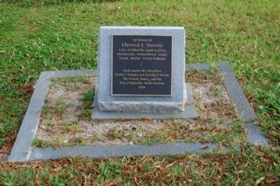
In Memory of
Clarence E. Pressley
A Son of Abbeville, South Carolina
Businessman - Humanitarian - Leader
Friend - Mentor - Family Protector — — Map (db m25197) HM
On Henry M. Turner Street at Secession Avenue, on the left when traveling south on Henry M. Turner Street.
Historical Bicentennial marker
in memory of
Henry McNeal Turner
1834-1915
Birthplace: Newberry, South Carolina - Boyhood home: Abbeville, South Carolina
Missionary Pioneer to South Africa, Liberation Theologian, Social and Political . . . — — Map (db m20249) HM
On Mount Carmel Road (South Carolina Route 823) at Mulberry Road, on the right when traveling south on Mount Carmel Road.
(Front)
The formal organization of Mulberry A.M.E. Church dates to c. 1871, but many of the founding members were formerly enslaved people who had a tradition of religious organization that stretched back into slavery. Early meetings were . . . — — Map (db m238574) HM
On Court Square (State Highway 202), on the right when traveling north.
The Lynching of Anthony Crawford
In Abbeville on Saturday, October 21, 1916, a white mob lynched a black leader named Anthony Crawford for cursing a white man. A 56-year-old planter, "Grandpa" Crawford owned 427 acres of land, had 13 . . . — — Map (db m101841) HM
Named in 1982
in honor of
a dedicated public
servant and
ardent supporter of
the construction of
Richard B. Russell Dam
Member, S.C. House
1949 — 1953
Served also as
Chairman
Abbeville County Council
Mayor, Lowndesville . . . — — Map (db m9442) HM
On Hampton Avenue Northwest at Florence Street Northwest, on the right when traveling east on Hampton Avenue Northwest.
Aiken Colored Cemetery. This cemetery, established in 1852 as a city cemetery, became Pine Lawn Memorial Gardens in 1988. The only burial ground for African Americans in Aiken until the mid-20th century, it was laid out by the City of Aiken . . . — — Map (db m239016) HM
On York Street SE at Richland Avenue (U.S. 78), on the right when traveling north on York Street SE.
In Commemoration Of The
Founding Of Aiken County
on
March 10, 1871
Celebrating 125 years
County Commissioners:
Sen. C.D. Hayne, Rep. Gloster Holland,
Rep. William B. Jones, Rep. Sam J. Lee,
William Peel, Rep. Prince Rivers, . . . — — Map (db m34610) HM
On Hampton Avenue Northeast at Kershaw Street Northeast, on the right when traveling east on Hampton Avenue Northeast.
This park is the site of Aiken Graded School, a two-story brick school built 1924-25. It was built for black pupils in grades 1-7 and was one of almost 500 S.C. schools funded in part by the Julius Rosenwald Foundation 1917-1932. Black Aiken . . . — — Map (db m239018) HM
On Richland Avenue East at Kershaw Street SE, on the right when traveling east on Richland Avenue East.
(Front)
This is one of the oldest historically Black churches in Aiken. It was organized in 1866 by formerly enslaved members of Aiken First (Front) Baptist Church. They were led by their first pastor. Rev. John G. Phillips, who was . . . — — Map (db m239072) HM
On Kershaw Street NW, on the right when traveling north.
This school was founded by the Freedmen's Bureau shortly after the Civil War to educate freedmen, women, and children. In 1868 Martha Schofield, a Quaker from Pennsylvania, came to Aiken and began her long career as superintendent. The school soon . . . — — Map (db m28821) HM
On Old Jackson Highway (State Highway 5), on the left when traveling north.
This church, one of the first black Baptist churches in America, grew out of regular worship services held as early as the 1750s at "Silver Bluff," the plantation of Indian trader George Galphin. At first a non-denominational congregation with . . . — — Map (db m31610) HM
On Barton Road at Boylan Street, on the right when traveling south on Barton Road.
(Front)
This African-American community was established in 1930 after two floods on the Savannah River washed away most of the town of Hamburg. That town had become a predominantly African-American community after the Civil War. Carrsville . . . — — Map (db m238689) HM
On Barton Road north of Boylan Street, on the left when traveling south.
(Front)
Providence Baptist Church was established by enslaved and free people of African descent in the town of Hamburg. After the Civil War Hamburg became a center of African American political power in Aiken County. In 1868 three members . . . — — Map (db m238687) HM
"Soul Music Queen" Rhythm & Blues Legend The Sharon Jones story begins and ends in North Augusta. Born May 4, 1956, she lived in North Augusta during her early years. She first sang publicly as an angel in a Christmas pageant at North . . . — — Map (db m234319) HM
On Barton Road at Boylan Street, on the right when traveling south on Barton Road.
(Front)
The Hamburg Massacre, which occurred nearby on July 8, 1876, was one of the most
notable incidents of racial and political violence in S.C. during Reconstruction. White Democrats across the state organized “rifle clubs” to . . . — — Map (db m238696) HM
On Huber Clay Road (State Highway 66) at Shephard Estates Drive, on the left when traveling south on Huber Clay Road.
Jacksonville School
Jacksonville School, built by the Jacksonville Lodge in 1895, taught the black children of this community until 1936. Grades 1-7, with two teachers, met in two classrooms on the first floor, without electricity or running . . . — — Map (db m31175) HM
On Flint Drive (State Highway 731) west of Bryan Drive, on the right when traveling east.
Jefferson High School Jefferson High School opened in 1956 as a junior high and high school for African-American students of Beech Island, Belvedere, Graniteville, Jackson, Langley-Bath-Clearwater, and North Augusta, with Herman W.W. Fennell . . . — — Map (db m31675) HM
On Railroad Avenue W (State Highway 3-10) near Memorial Avenue (State Highway 3-71), on the right when traveling west.
(Front text)
This church, founded soon after the Civil War, held its first services in a brush arbor in the Woods community of what was then Barnwell County. It built its first permanent church, a frame building, in the Zion Branch . . . — — Map (db m49489) HM
On East Church Street west of South McDuffie Street.
“At night it would be so packed you had to walk, you couldn't get a car down Church Street. Sometimes there would be a little disturbance but things mostly got worked out. Eventually we got two black cops, Bobby Clinkscales and . . . — — Map (db m185370) HM
On South Fant Street (State Highway 22) at East River Street (U.S. 76), on the right when traveling north on South Fant Street.
The location of the Anderson County Courthouse Annex on the corner of Fant and River Street has unique significance to Anderson's history. The site is the location of the 1865 federal encampment of the First Maine, 33rd Regiment, United States . . . — — Map (db m19838) HM
Near North Main Street (U.S. 29), on the right when traveling north.
This building was erected as a passenger station for the Blue Ridge Railroad. It bridges the railroad cut under North Main Street which was excavated by the Blue Ridge Railroad Company as part of a project to build a line over the mountains to . . . — — Map (db m94745) HM
On South Main Street (South Carolina Route 28) south of East River Street (U.S. 178), on the right when traveling north.
Lynching in America
Between 1865 and 1950, at least 6,500 Black people were victims of lynchings in the United States. The abolition of chattel slavery was not accompanied by a commitment to equal rights or protection for Black people. In many . . . — — Map (db m237660) HM
“I was always told that if you wanted to amount to anything in life, you should be like the business people on Church Street. It was the most viable part of the black community. Besides that, there were very few places where . . . — — Map (db m185371) HM
On West Reed Street at South Towers Street on West Reed Street.
After another high school was built, Reed Street High was renamed Perry Elementary School.
Perry Elementary later became known as
Perry Child Development Center.
This memorial is dedicated to the students teachers and principals who were a . . . — — Map (db m60542) HM
On West Reed Street, on the right when traveling west.
This is the first Negro church established in Anderson County. It was founded immediately after emancipation and incorporated in 1873. The Rev. Philip Morris was its first pastor. The present edifice, built in 1903, replaced two earlier frame . . . — — Map (db m60543) HM
On West Church Street west of South Main Street (State Highway 28).
Church Street was a thriving center for African-American commerce in Anderson, South Carolina from (circa) 1907 until 1980, when most of the buildings were torn down to make way for a parking lot. The citizens on Church Street were educated, . . . — — Map (db m185372) HM
On South Fant Street, on the left when traveling south.
The Horace Greeley Institute Trust was established in 1870 in the name of abolitionist Horace Greeley. Because the trust was to be used for the advancement of the education of "Freedmen and their Children," a school, known as the Greeley Institute, . . . — — Map (db m61078) HM
This structure is called a "sweatbox" and was commonly used throughout the United States as a government-recommended method of disciplining prisoners during the mid-1900s. It was very much despised and feared by the prisoners, who referred to it as . . . — — Map (db m19917) HM
On West Market Street near South Murray Avenue (South Carolina Highway 81), on the right when traveling east.
This was the second Negro church founded in Anderson. It was organized at a meeting of approximately 15 persons at the home of the Rev. Henry A. Mikell, who served as the first pastor. A lot was purchased from Bale Clayton for $100 and a small . . . — — Map (db m11745) HM
Near Sayre Street (U.S. 29), on the right when traveling south.
In Memory of World War Casualties
War No. I
Thomas Adjer
Scott Hill
Ollie Rutledge
War No. II
James Joyner
Johnnie M. Leroy
Frank Lewis
John M. McBride
Mayor
Richard A. Shirley
City Manager
John R. . . . — — Map (db m49493) HM
Near County Road 16, on the right when traveling east.
William A. Floyd, a man of vision, served Anderson County as the first African-American elected to the Anderson County Council. He touched the lives of many county residents in various ways, as a husband, father, teacher, coach, councilman, . . . — — Map (db m21328) HM
This area was a hub of African-American life from the late-19th to mid-20th centuries. Anderson County Training School, built ca. 1922 as a Rosenwald school, closed in 1954 under the equalization program for black and white schools. It burned in . . . — — Map (db m54824) HM
On Vance Street, on the right when traveling west.
The one-room frame public school organized shortly after the Civil War, housed 76 students and 1 teacher by 1870. The school term lasted 1 month and 10 days. Jane Harris Hunter, founder of the Phillis Wheatley centers for working girls, attended . . . — — Map (db m9647) HM
On History Lane, on the right when traveling west.
Some 200 yards west of here stands Woodburn, built by S.C. Lieutenant Governor Charles Cotesworth Pinckney by 1832. Dr. John B. Adger, Presbyterian minister to Armenia, bought Woodburn in 1852; in 1881 Augustine T. Smythe began a model stock farm . . . — — Map (db m9588) HM
On East Voorhees Road (State Highway S-5-12) near Soloman Blatt Boulevard, on the right when traveling east.
[Front Text]
Voorhees College, founded by Elizabeth Evelyn Wright
in 1897 as the Denmark Industrial School, was an
effort to emphasize a vocational curriculum for
rural African American students on the model of
the Tuskegee Institute. . . . — — Map (db m19639) HM
On Dexter Street (State Highway 78), on the right when traveling west.
[Front text]:
This church, the first African-American Baptist church in Barnwell County, was founded in 1866 when Rev. James T. Tolbert preached in Blackville under a brush arbor; the first sanctuary was built in 1868. The church hosted . . . — — Map (db m28080) HM
On Boundary Street (U.S. 21), on the right when traveling west.
The 1st South Carolina Volunteer Infantry Regiment
was raised from sea island slaves living around Port
Royal. Elements of the regiment were formed on Hilton
Head in May 1862. In August 1862, the regiment was
reorganized near Beaufort at the . . . — — Map (db m7094) HM
On Craven Street just east of Scott Street, on the right when traveling east.
Prior to the Civil War, Beaufort was home to some of South Carolina's wealthiest citizens who had grown rich from the Sea Island Cotton harvested by the people they enslaved. In 1863, after more than a year of US Military occupation, the prewar . . . — — Map (db m227253) HM
On Charles Street north of King Street, on the left when traveling north.
(side 1) The Baptist Church of Beaufort descends from Euhaw Baptist Church on Edisto Island. In 1794 the first meeting house was built on this site. In 1795 Henry Holcombe moved to Beaufort and became the first mission pastor. The Beaufort . . . — — Map (db m133292) HM
On Boundary Street (U.S. 21), on the right when traveling east.
(Front Text):
Battery Saxton, constructed here in 1862, was in the second line of earthworks built by Federal troops occupying Beaufort during the Civil War. Laid out by the 1st New York Engineers with the assistance of black laborers, it . . . — — Map (db m6985) HM
On Carteret Street (U.S. 21), on the right when traveling west.
Beaufort College, a college preparatory academy founded in 1795, occupied this Greek Revival building from 1852 to 1861. The school opened in 1804 at Bay and Church Sts. but closed in 1817 after a yellow fever epidemic, reopening in 1820 at . . . — — Map (db m218213) HM
Near Boundary Street (Business U.S. 21) west of Bladen Street, on the right when traveling west.
National Cemetery Beaufort National Cemetery was established in 1863. The U.S. Army Quartermaster General's Office laid out the 22 acres in sections that radiate outward from a central plaza to form a half circle. Of the 9,226 interments here . . . — — Map (db m134421) HM
On Carteret Street (Business U.S. 21) south of Prince Street, on the right when traveling south.
Berean Church (side 1)Berean Presbyterian Church was founded by Samuel J. Bampfield, an influential African American political figure during Reconstruction. Bampfield served in the S.C. House of Representatives, was Beaufort's postmaster, . . . — — Map (db m133351) HM
Near Craven Street just east of Scott Street, on the right when traveling east.
Welcome to Reconstruction Era National Historical Park. This unit of the national park system was established in January 2017 to preserve and interpret the resources and complex national stories of Reconstruction — African Americans' quest for . . . — — Map (db m227256) HM
This church, founded in 1865, grew out of an antebellum praise house for black members of the Baptist Church of Beaufort. During the Civil War, after the Federal occupation of the town, it hosted a school for freedmen. Rev. Arthur Waddell . . . — — Map (db m103224) HM
On Newcastle Street south of Duke Street, on the right when traveling south.
(side 1) This building was built ca. 1896 by the David Hunter Post No. 9, Grand Army of the Republic (G.A.R.) The G.A.R., founded in 1866, was a fraternal society for veterans of the Union army and navy, with white and black posts. David . . . — — Map (db m133383) HM
On Ribaut Road (State Highway 281) 0 miles south of Reynolds Street, on the right when traveling south.
Shortly after the Civil War, Mather School was founded here by Rachel Crane Mather of Boston. In 1882 the Women's American Baptist Home Mission Society assumed support of the venture, operating it as a normal school for black girls. With some . . . — — Map (db m6940) HM
(Tablet One)
The Governor of the Commonwealth of
Massachusetts Michael S. Dukakis, and
descendant's of the African-American Civil
War Volunteers of the 54th and 55th Infantry
Regiments and the 5th Cavalry Regiment of
Massachusetts, . . . — — Map (db m20211) HM
On Craven Street at Charles Street when traveling east on Craven Street.
Born a slave in 1839, Robert Smalls lived to serve as a Congressman of the United States. In 1862 he commandeered and delivered to Union forces the Confederate gunboat Planter, on which he was a crewman. His career as a freedman included service as . . . — — Map (db m20144) HM
On Craven Street near Charles Street, on the right when traveling west.
Tabernacle Church was formed by black members of Beaufort Baptist Church after other members evacuated the area because of Federal occupation in 1861. The church's lecture room was used for services during the war. In 1867 the black congregation . . . — — Map (db m9964) HM
On Prince Street at West Street, on the right when traveling west on Prince Street.
(side 1) This church, established in 1833, was the first Methodist church in Beaufort and was founded as a mission to slaves and free blacks here and on the neighboring Sea Islands. The congregation had both black and white members but many . . . — — Map (db m133501) HM
On Boundary Street north of Maiden Lane, on the right when traveling north.
Built in 1853, this was originally Bluffton Methodist Episcopal church. Organized by whites, the church's 216 members in 1861 included 181 African Americas, who were likely enslaved to its white congregants. The church caught fire during the . . . — — Map (db m218551) HM
On Wharf Street, 0.1 miles south of Bridge Street, on the right when traveling south.
Cyrus Garvin
Little is known of Cyrus Garvin's early life. He was likely born into slavery, possibly on a plantation of the Baynard family. Garvin is notable for having amassed considerable status and property after emancipation. In . . . — — Map (db m218662) HM
(Front text):This is the site of two schools
that served the black community of southern Beaufort County for most of the twentieth century. Bluffton Graded School, a small frame building constructed about
1900, was followed in 1954 by an . . . — — Map (db m5853) HM
On Dr. Martin Luther King Drive (State Highway S-7-45), on the right when traveling south.
( Front text )
On the night of August 27, 1893, a
huge "tropical cyclone," the largest
and most powerful storm to hit S.C.
until Hurricane Hugo in 1989, made
landfall just E of Savannah, Ga.
With gusts as high as 120 mph and a
storm . . . — — Map (db m8782) HM
On Beach City Rd, 0.7 miles Dillon Rd, on the right.
Early A.M.E. Missionaries to South Carolina, Rev. James H.A. Johnson and Rev. James A. Handy, arrived at Hilton Head on the Steamship Arago at 3:18 p.m. Friday, May 12, 1865.
Rev. James Lynch, also an A.M.E. Missionary, shared entertainment . . . — — Map (db m104498) HM
Near Beach City Road, 0.4 miles north of Dillon Road, on the right when traveling north.
The first black troops in the Union Army enlisted on Hilton Head Island in May 1862. Initially, men who escaped plantations and slavery were reluctant to join the army. They did not want to leave their families and new financial opportunities and . . . — — Map (db m105295) HM
On Dillon Rd at City Beach Rd, on the right on Dillon Rd.
(Front)
This one-room frame school, built ca. 1937, was the first separate school building constructed for African-American students on Hilton Head Island. It replaced an earlier Cherry Hill School, which had held its classes in personage of St. . . . — — Map (db m104496) HM
On City Beach Rd, 0.3 miles south of Hunter Rd, on the right.
Oldest Baptist church on Hilton Head Island
Organized August 17, 1862
in the town of Mitchelville
with 120 members
Building was moved to present location
later and rebuilt in 1966
Rededicated October 30, 1988
Rev. C.W. Aiken, Pastor . . . — — Map (db m104497) HM
On Beach City Road at Eneterprise Lane, on the right when traveling north on Beach City Road.
This church, organized in 1862, was first located in the town of Mitchelville, a freedman’s village established on Hilton Head by the United States Army. Rev. Abraham Murchinson, its first pastor, was a former slave. The congregation numbered . . . — — Map (db m104580) HM
On Fish Haul Road near Mitchelville Road, on the right when traveling east.
This plantation was part of a 1717 Proprietary landgrant of 500 acres to Col. John Barnwell. Later owners included members of the Green, Ellis, and Pope families. Nearby tabby ruins are remains of fire places of slave cabins. Graves of blacks, who . . . — — Map (db m6625) HM
On Beach City Road at Dillon Road, on the left when traveling north on Beach City Road.
An excellent example of the defensive earthworks common to the civil War era, Fort Howell was constructed by Union Forces occupying Hilton Head Island and was one of the final fortifications to be built during the war.
The men of the 32nd U.S. . . . — — Map (db m6801) HM
Near Beach City Road, 0.4 miles Dillon Road, on the right when traveling north.
Interest in the freedom seekers of Mitchelville and the surrounding areas led to an outpouring of assistance from Northern missionaries and abolitionists. They organized and sent aid and teachers. Newspaper reporters came to document conditions . . . — — Map (db m105263) HM
Near Beach City Road, 0.4 miles Dillon Road, on the right when traveling north.
The Maps and Pictures below identify the approximate locations of roads and buildings that were in Mitchelville circa 1862-1868.The Town of Mitchelville had praise houses, stores, schools and numerous homes. Unfortunately no physical remains of . . . — — Map (db m105156) HM
On Beach City Road near Dillon Road, on the left when traveling east.
In 1862, after Hilton Head's fall to Union
forces in 1861, this town, planned for the
area's former slaves and named for General
Ormsby M. Mitchel, began. — — Map (db m6783) HM
On Beach City Road, 0.1 miles north of Hunter Road, on the right when traveling north.
(front)
The congregation of Queen Chapel can trace its roots to May 1865 when A.M.E. missionaries Rev. R.H. Cain, Rev. James H.A. Johnson and James A. Handy arrived on Hilton Head Island. They visited the Freedman’s town of Mitchelville . . . — — Map (db m104583) HM
Near Beach City Road, 0.4 miles Dillon Road, on the right when traveling north.
Reuniting with family was one of the first concerns of African slaves who escaped to Hilton Head Island. Slavery split up families. Owners could sell family members for profit or punishment. On Hilton Head Island, and places where freedom seekers . . . — — Map (db m105209) HM
Near Beach City Road, 0.4 miles north of Dillon Road, on the right when traveling north.
Religion in Mitchelville
Before Mitchelville was established, African slaves on the island congregated at impromptu religious services under trees. The churches built in Mitchelville were the center of religious, social, political, and . . . — — Map (db m105172) HM
On Beach City Road at Dillon Road, on the right when traveling north on Beach City Road.
This church, founded in 1886 by former members of First African Baptist Church, is one of the oldest surviving institutions remaining from the town of Mitchelville, a freedmen’s village established here by the United States Army in 1862. The present . . . — — Map (db m44098) HM
Near Beach City Road, 0.4 miles north of Dillon Road, on the right when traveling north.
The Battle of Port Royal
On November 7, 1861, at the Battle of Port Royal Union forces attacked Confederates at Fort Walker on Hilton Head island and Fort Beauregard at Bay Point.The Union deployed the largest amphibious fleet ever assembled . . . — — Map (db m105290) HM
Near Beach City Road, 0.4 miles north of Dillon Road, on the right when traveling north.
During the civil War, Union forces defeated the Confederates on Hilton Head Island at the Battle of
Port Royal on November 7, 1861. Cannon fire from that battle heralded a dawn of freedom for millions of African slaves throughout the South. . . . — — Map (db m105121) HM
Near Beach City Road, 0.2 miles south of Dillon Road, on the right when traveling south.
The Troops that Built Fort Howell
Construction of Fort Howell was begun by the 32nd U.S. Colored Infantry and completed by the 144th New York Infantry. The 500-man 32nd Colored Infantry was organized at Camp William Penn, Philadelphia, . . . — — Map (db m131839) HM
Near Beach City Road, 0.4 miles north of Dillon Road, on the right when traveling north.
Working for Wages
African slaves who escaped their plantations and worked for the Union military earned between six and eighteen dollars a month as carpenters, blacksmiths, drivers, boatmen, and laborers. Others worked as cooks and servants . . . — — Map (db m105254) HM
Taming the Wilderness
1715 - 1750
In 1715, Alexander Parris aquired what would come to be known as Parris Island. By 1722, Parris gave almost half the island to his daughter Jane and her husband John Delabare. Both families established . . . — — Map (db m21410) HM
On 11th Street, 0.1 miles west of Madrid Avenue, on the left when traveling west.
(side 1)
In 1939, the Blue Channel Corporation opened a crab canning factory on this site. Founded by inventor Sterling Harris, the company worked with food scientist Dr. Carl Fellers to patent a process that eliminated the blue . . . — — Map (db m219679) HM
On New Years Day 1863 this plantation owned by John Joyner Smith was the scene of elaborate ceremonies celebrating the enactment of the Emancipation Proclamation. Hundreds of freedman and woman came from Port Royal, Beaufort and the sea islands to . . . — — Map (db m218503) HM
In Honor Of
Edith M. Dabbs
for her work and leadership in preserving
historic documents and photographs of Penn
School and for her contributions as author of
Face of an Island and Sea Island Diary
and
James McBride . . . — — Map (db m13432) HM
On Dr. Martin Luther King Drive (State Highway S-7-45), on the right when traveling south.
[front text]
One of the first schools for blacks in the South, Penn School, was reorganized as Penn Normal, Industrial and Agricultural School in 1901. As a
result of this change, incorporating principals of education found at both . . . — — Map (db m20294) HM
On Trask Parkway (U.S. 17 / 21) 0.1 miles north of Sheldon Drive when traveling north.
(Front):
Sheldon Union Academy, later Sheldon School, opened in 1893 on this site and educated the black children of rural Sheldon community for almost fifty years. The original Sheldon Union Academy board, which founded and governed the . . . — — Map (db m5785) HM
On Charleston Highway (U.S. 17) near Boat ramp driveway, on the right when traveling south.
Combahee River Raid
On June 1-2, 1863, a Federal Force
consisting of elements of the 2nd
S.C. Volunteer Infantry (an African-
American unit) and the 3rd Rhode
Island Artillery conducted a raid
up the Confederate-held Combahee
River. . . . — — Map (db m66105) HM
This African-American community grew up around a Methodist church founded during Reconstruction by a freedman named Casey or Caice. Its early services were under a tent, but a log cabin served as its first permanent church. In 1868 T.W. Lewis and . . . — — Map (db m29486) HM
On Saint James Avenue (U.S. 176) north of Wilmer Avenue, on the right when traveling south.
(front)
From the 18th century, the State Road from Charleston and the Road to Dorchester met near here. These paths connected Charleston to the S.C. interior. Travelers from Charleston would have crossed Goose Creek, two miles south, . . . — — Map (db m206675) HM
On Howe Hall Road near Red Bank Road, on the left when traveling east.
(Front text) Howe Hall Plantation Howe Hall Plantation was established here by Robert Howe about 1683 and passed to his son Job Howe (d. 1706), Speaker of the Commons House of Assembly 1700-05. Later owned by such prominent lowcountry . . . — — Map (db m28079) HM
On Foster Creek Road at Ford Boulevard on Foster Creek Road.
Bowen's Corner, an African-American farming community from the mid-19th century through the late-20th century, was originally part of a rice plantation established along Goose Creek in 1680. That tract was granted by the Lords Proprietors to Barnard . . . — — Map (db m29500) HM
On Main Street (State Highway 6) at U.S. 52 on Main Street.
[Front] Berkeley Training High School, first called Dixie Training School, stood here from 1920 until the 1980s. The first public school for blacks in Moncks Corner was founded in 1880. It held classes in local churches until its first . . . — — Map (db m29133) HM
On Russellville Road (State Highway 8-18) at Cedar Drive, on the left when traveling west on Russellville Road.
(Marker Front)St. Stephen Colored School St. Stephen Colored School, the first public African American school in St. Stephen, was built here in 1924-25. A three-room frame building, it was one of almost 500 schools in S.C. funded in part . . . — — Map (db m29334) HM
On McCord’s Ferry Road (State Highway 267) at Friendly Lane, on the right when traveling north on McCord’s Ferry Road.
The Good Hope Picnic, a celebration of the end of the planting season, is the oldest African-American event in the Lone Star community. Founded in August 1915 by farmers to market their produce and held on the second Friday in August, it has . . . — — Map (db m27879) HM
On Fort Motte Road (State Highway 419), on the left when traveling south.
The first church built by African Americans at Fort Motte grew out of services held by slaves at nearby Bellville, Goshen, Lang Syne, and Oakland plantations. It was formally organized in 1867 by Caleb Bartley, Israel Cheeseborough, Cudjo . . . — — Map (db m26789) HM
On Broad Street, 0.1 miles east of Church Street, on the right when traveling west.
During the first half of the nineteenth century, many buildings on Broad Street between Church and East Bay Streets served as auction houses and private venues for the sale of human property. The firm of William Payne & Sons was likely the busiest . . . — — Map (db m242571) HM
On Drake Street at Columbus Street, on the right when traveling north on Drake Street.
Cigar Factory This five-story commercial building, built in 1882 as a textile mill, was known as the Charleston Manufacturing Company, then Charleston Cotton Mills, in its early years. Leased to the American Tobacco Company in 1903, the plant . . . — — Map (db m67363) HM
On Ashley Avenue at Doughty Street, on the left when traveling north on Ashley Avenue.
Civil rights marches on Ashley Ave. and elsewhere occurred during strikes at two
hospitals from March 20 to July 18, 1969. Workers, mostly black women, cited unequal
treatment and pay when they organized and walked out of the Medical College . . . — — Map (db m182111) HM
On 3550 Ashley River Rd (SC-61), on the right when traveling north.
Fountainhead of the Drayton family, which
played so important a part in America's
Colonial, Revolutionary, and Independence
history. Its original plantation house, credited
by contemporary historians as having been
the earliest in the Carolina . . . — — Map (db m14853) HM
On Folly Road (South Carolina Route 171) at Sol Legare Road, on the right when traveling east on Folly Road.
(front)
Located 1.5 mi. SW of here, Mosquito Beach is a .13-mile strip of land that served African Americans during the Jim Crow era, when nearby Folly Beach was segregated. The beach began as a gathering spot for workers at a nearby . . . — — Map (db m242395) HM
On Chalmers Street west of State Street, on the right when traveling west.
(front)
This was the south end of a large slave trading complex known as The Mart or Ryan's Mart. It was opened in 1856 by Thomas Ryan after the City banned auctions of enslaved people and other goods from streets near the Exchange . . . — — Map (db m242255) WM
On Queen Street west of State Street, on the left when traveling west.
From 1856 to 1863, this was the north end of a slave trading complex known as The Mart or Ryan's Mart. It was opened by Thomas Ryan and extended south to a lot on Chalmers St. that became its main sales room. Prior to auction, enslaved people . . . — — Map (db m242347) HM
On Ashley River Road (South Carolina Route 61) 0.1 miles south of Plainview Road, on the right when traveling north.
St. Andrew's Parish Church was one of ten Anglican churches established in S.C. by the Church Act of 1706.
The church was built in 1706, expanded in 1723, and restored in 1764 after a fire. It is the only extant colonial cruciform church in . . . — — Map (db m242802) HM
500 entries matched your criteria. The first 100 are listed above. Next 100 ⊳