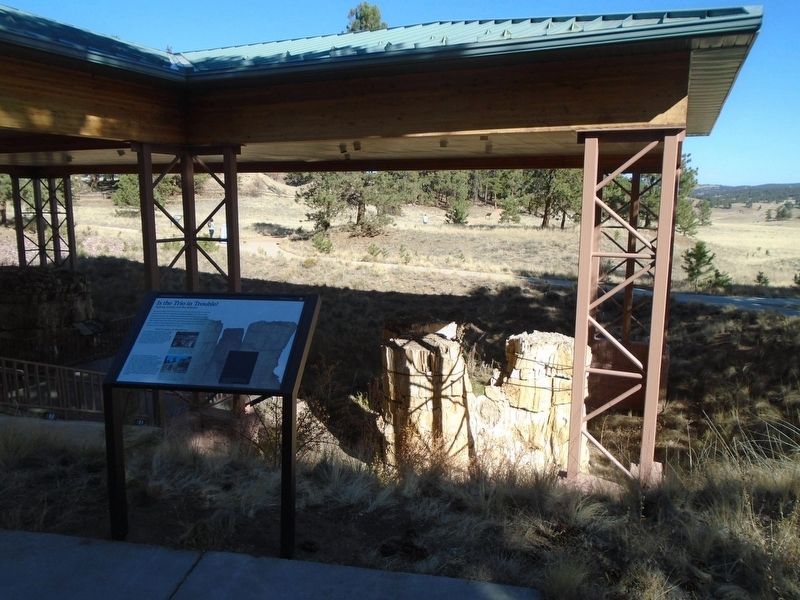
The three trunks of the Trio are all interconnected because they are part of the same tree! They were likely sprouts from a broken central tree, which makes them clones. The original rock matrix that buried the Trio in the late Eocene was excavated . . . — — Map (db m240476) HM
"One of the wonders of this part of the world is the 'Petrified Forest'...between Colorado Springs and Fairplay. This remarkable relic...bids fair to disappear very shortly, unless the...tourists cease their work of destruction. Everyone must . . . — — Map (db m158483) HM
To uncover the geologic history of the Florissant region, you must peel back the surface and examine the rock layers below. Sediments are deposited layer upon layer, with the oldest at the bottom and the youngest on top. Because of this principle . . . — — Map (db m158482) HM
The Abert's squirrel inhabits this forest. It eats ponderosa pine cones and the inner bark of the twigs. It's just one of many animals that depend on the ponderosa forest for food, nesting, and cover. The fossil record also shows animals and plant . . . — — Map (db m158510) HM
Pikes Peak is the huge mountain you see across the valley. On a clear day, you can see two distinct areas on the mountain—a darker band of forest and a lighter colored treeless area. These different layers called "life zones" are a . . . — — Map (db m158493) HM
A grassroots effort
Beneath this valley is one of the richest fossil deposits in the world. Imagine instead this valley filled with a housing subdivision. There would be no open space, no trails, no scientific research, and no . . . — — Map (db m158376) HM
Core samples from Sequoia affinis fossil stumps contain remarkably well-preserved annual growth rings. Locked within those concentric rings are clues about past growing conditions in the Florissant valley.
The stumps at Florissant have . . . — — Map (db m158428) HM
In the late Eocene epoch, about 34 million years ago, the Florissant valley was buried by eruptions from a cluster of volcanoes known as the Guffey volcanic center. Huge volcanic mudflows (lahars) spread into this forested valley with great speed, . . . — — Map (db m158402) HM
Just beyond the circular wooden fence in front of you is a young ponderosa pine tree growing out of the top of an ancient petrified redwood tree stump. The huge redwood tree was buried by a volcanic mudflow and was later exposed by erosion. The . . . — — Map (db m158515) HM
Can you see the spiral scar on the ponderosa pine directly to your right? It goes all the way up and around the tree. Lightning struck this tree many years ago. Lightning and the fires it causes are natural processes in forests like this one. Fire . . . — — Map (db m158506) HM
You are standing in the Florissant valley surrounded by ponderosa pine forests. But 34-35 million years ago, this was the site of Lake Florissant. The twelve-mile-long lake was formed when volcanic mudflows dammed a stream that flowed south . . . — — Map (db m158489) HM
Rich Cultural History
The legacy of many different cultures and people can be found along the Byway. Native
American Indian tribes who lived here for centuries prior to settlement have left traces of their life ways in the earth, trees and . . . — — Map (db m153243) HM
Welcome to Wethersfield!
We invite you to explore Wethersfield’s story as you travel through the centuries. The Wethersfield Heritage Walk is a three mile long, self-guided tour consisting of a series of twenty-two interpretive markers that . . . — — Map (db m302062) HM
Size: 1.5-2.5 feet at shoulder
Weight: 66-88 pounds
Lifespan: Up to 9 years
Habitat: Dry thorn forests, plains and marshes of South America
Diet: Cacti, tubers, fruits, flowers
Othniel Charles Marsh
Born at Lockport, N.Y. October 29, 1831. Died at New Haven, March 18, 1899
Professor of Paleontology in Yale University 1866 – 1899
President of the National Academy of Sciences 1883 – 1895
Eminent as . . . — — Map (db m50917) HM
Historic Roads of Newark, Delaware
1. Old Baltimore Pike
The Old Baltimore Pike was built before 1720 and connected Elkton, Maryland to Christiana. It followed the path of an east-west Indian trail over the south side of Iron Hill. . . . — — Map (db m214020) HM
Legend has it that the Potomac was once home to these wondrous beasts.
George and Martha Washington are even said to have watched them cavort in
the river shallows from the porch of their beloved Mount Vernon on summer evenings. . . . — — Map (db m46980) HM
Legend has it that the Potomac was once home to these wondrous beasts. George & Martha Washington are even said to have watched them cavort in the river shallows from the porch of their beloved Mount Vernon on summer evenings. Credited with . . . — — Map (db m179003) HM
Triceratops roamed northwestern North America 70-65 million years ago, when the climate was much warmer and wetter. It dined on plants that included relatives of those you see here.
This cast was created from the skull of our . . . — — Map (db m113990) HM
The Florida Museum traces its roots to the 1890s at Florida Agricultural College in Lake City. In 1906, the collections moved to the UF campus in Gainesville. On May 30, 1917, the Florida State Museum became the state's official natural history . . . — — Map (db m134906) HM
Discovered by accident in 1982, the Windover site is a burial place of Early Native Americans who inhabited this region 7,000 to 8,000 years ago. The burials were placed underwater in the peat of the shallow pond. This peat helped to preserve . . . — — Map (db m60342) HM
(side 1)
The Bayport Area Before Human Occupation
The fossilized remains of many prehistoric animals and plants are buried in the Bayport area. During the Eocene Period, 45 million years ago (MYA), the Gulf covered this region. . . . — — Map (db m93296) HM
In the ponds in front of you one of the richest Ice-Age fossil discoveries in the world took place in 1983-84. When amateur paleontologists reported a large accumulation of fossils to the Florida Museum of Natural History, the Leisey Shell Pit and . . . — — Map (db m120625) HM
The plants and animals you see along the Trail have remained virtually unchanged since the late Cretaceous. The dinosaurs themselves were not as fortunate, disappearing from the earth 65 million years ago. — — Map (db m243014) HM
This fossil Gateway is composed of the
giant bones of a Brachiosaurus, one of the
largest creatures that ever walked the earth.
It stands fifty-two feet tall and more than
eighty feet long. A peaceful plant-eater,
the Brachiosaurus' enormous . . . — — Map (db m198209) HM
Millions of years ago, dinosaurs roamed vast coniferous forests filled with ancient trees, colossal cycads, ferns, and mosses.
Over millennia of geological transformation, these prehistoric plants became the coal and oil we use as fuel . . . — — Map (db m242850) HM
This fossil cast is an exact replica of “Sue”, the most complete Tyrannosaurus Rex skeleton ever found. Named for her discoverer, Sue was found in South Dakota on August 12, 1990. Sue is 90% complete, a fossil find of enormous importance to the . . . — — Map (db m76896) HM
The waters of this unusual archeological and paleontological site have yielded preserved human skeletal remains and artifacts dating from 10,000 to 3000 B.C. Animal fossils have also been recovered. Including species of extinct tortoise, sloth, . . . — — Map (db m128665) HM
Prehistoric Man Lived Here
More than 10,000 years ago prehistoric man, sabre-tooth cats, giant sloths, mammoths and mastodons lived in this area of Florida which eons later became a part of Sarasota County. Warm Mineral Springs, here, and . . . — — Map (db m128664) HM
"It's a mammoth," voiced Dr. J. W. Gidley, Paleontologist of the Smithsonian Institute, 15 minutes after he first saw the fossil tusks and jaw bone of the prehistoric monster found in Venice. The size of the tusks indicates that it probably stood 14 . . . — — Map (db m32747) HM
Within a mile and a half of this marker are numerous prehistoric sites, several of which date from 2000 BC. Native Americans occupied the northern river section from about 4000 BC until the arrival of Europeans after 1500 AD. Riverbank . . . — — Map (db m236728) HM
Several attempts were made to operate Dunlawton Plantation as a tourist attraction in the the 1950's Dr. Perry Sperber leased the premises from J. Saxon Lloyd for a park to display prehistoric monsters and had a number of replicas, molded in . . . — — Map (db m34878) HM
On this site in 1975 was found the best preserved and most complete giant ground sloth ever found in North America.
The sloth weighed three to five tons, stood thirteen feet tall and was a vegetarian.
An estimated fifty species of animals were . . . — — Map (db m45449) HM
Lophorhothon atopus
(Loh-FOUR-ah-thon ay-TOH-pus)
“Crested Nose”
Cretaceous Period (65- 144 million years ago)
Southeastern United States
This scene shows a family of Lophorhothon dinosaurs, as they may have . . . — — Map (db m113593) HM
Archaeologists seek to understand people and places of the past by studying the sites and cultural remains left behind. Students from the University of Hawai'i conducted extensive excavations here between 1968 and 1970 to learn about the people of . . . — — Map (db m110325) HM
You are standing in the outlet of ancient Lake Bonneville, a vast prehistoric inland sea, of which Salt Lake is modern remnant
Covering over 20,000 square miles when it overflowed here about 14,500 years ago, its winding shoreline would have . . . — — Map (db m105831) HM
Noticeable for their distinct shapes, China Hat and nearby China Cap are rhyolite domes that intruded and pierced the basalt of the Blackfoot Lava Field. The basaltic phase of this volcanic province was active in middle Pleistocene around 500,000 . . . — — Map (db m105966) HM
Diverted into this valley by lava flows, the Bear River deposited a huge, mostly red clay delta here where it entered a vast inland sea that covered much of Utah.
About 14,500 years ago , its shoreline suddenly went down about 80 feet . . . — — Map (db m105834) HM
Idaho was a very different place during the Pliocene Epoch (three to four million years ago). Like much of the planet, this area was warmer and more humid, with annual rain fall of 20 inches. Studies of ancient pollen found in the sand and clay . . . — — Map (db m139552) HM
A trained eye, persistence - and a good deal of luck - often lead paleontologist to new fossil discoveries.
New fossil localities are discovered every year. Currently Hagerman Fossil Beds National Monument monitors over 600 fossil bearing . . . — — Map (db m139609) HM
The rock layers in the bluff across the river are made of sediments - particles of sand, silt, and clay. These layers, called strata, were carried here by the ancient Snake River and were deposited as the river entered an ancient lake. This process . . . — — Map (db m139554) HM
Step back in time, three to four million years, and imagine a place were zebra-like horses, ground sloths, mastodons, and other amazing creatures roamed. Hagerman Fossil Beds National Monument is filled with fossil evidence of their existence in . . . — — Map (db m139551) HM
Can you imagine mammoths walking the streets of Grangeville? Before Sept. 2, 1994, no one else could either. But on that date, a heavy equipment operator for Prairie Land and Timber, found a "big bone" when he was digging in Tolo Lake. That . . . — — Map (db m141309) HM
(Three panels outline the history of Tolo Lake)
The Nez Perce name for this lake is Tipahxlee’whum (Tepahlewam or Split Rocks). In early June 1877, five bands of Nimiipuu gathered here for their last taste of freedom before . . . — — Map (db m121267) HM
Look Up!
You're looking up at a full-size replica of the skeleton of a male Columbian mammoth. Mammoths are related to modern Asian elephants. Males stood up to 14 feet tall at the shoulders and may have weighed 10 tons. Females were . . . — — Map (db m141310) HM
Bone fragments of extinct species of ground sloth, horse, camel, and elephant found in a nearby cave mingle with weapons and radiocarbon dates from Idaho’s earliest hunters.
Archaeologists have confirmed that people camped here at least . . . — — Map (db m62963) HM
On October 16, 1963, an excavation for a pond approximately 100 yards east of here, contracted by U.S. District Court Judge Sam Perry, uncovered a fossilized thigh bone. It was identified by the Field Museum of Chicago to be the bone of a . . . — — Map (db m249606) HM
Lester Frank Ward
The American Aristotle
The last of ten children, Lester Frank Ward (1841-1913) was born in Joliet, at Joliet and Benton streets. His father owned a quarry at what is now the site of the Illinois State Penitentiary, . . . — — Map (db m157403) HM
By the Way: Lewis and Clark began their famous expedition from this area on October 26, 1803.
Almost 400 million years ago, during the Devonian age, future states Indiana and Kentucky were asleep beneath a warm tropical sea, located about . . . — — Map (db m206956) HM
Dedicated in 1912, starting with approximately 600 books; collections and services have expanded to meet needs of local patrons. One of 1, 679 libraries built in U.S. with funds from philanthropist Andrew Carnegie. Indiana built more Carnegie . . . — — Map (db m44694) HM
The Princeton you see today is not as it always was. Over billions of years, natural processes have drastically affected the climate, flora & fauna, & even the geographic location of what is now Princeton. Between 420 & 359 million years ago, during . . . — — Map (db m190585) HM
37 fiberglass tulip structures, which were organized and made possible by the Munster Civic Foundation, are located around town. Indiana University Northwest student, Tyler Kaufman, designed the tulip structures. The tulips represented the first . . . — — Map (db m301768) HM
Nearly vertical strata found in the stone at the Kentland Crater evoke theories about either a meteorite impact or a major earthquake 65 million years ago. George Ade, popular newspaper columnist and playwright from the 1890s through the 1940s, was . . . — — Map (db m238766) HM
Iowa is underlain by bedrock layers composed of
sedimentary rocks; layers of Devonian limestone bedrock
of the Cedar Valley Group are well displayed in the Gorge.
Sedimentary rocks were formed from accumulated layers
of mud, sand or organic . . . — — Map (db m185715) HM
Over 100 million years ago, during the cretaceous era, Kansas was covered by a vast ocean. Dramatic natural features, such as the Monument Rocks, are remains of that ancient seabed.
Since the 1870s, fossil hunters have searched the chalk beds . . . — — Map (db m66099) HM
Huge continental glaciers, hundreds of feet thick, came from the north to northeastern Kansas in at least two different episodes carrying rocks, gravel, sand, and a special clay called loess to the Blue Rapids area. Our fertile soils and . . . — — Map (db m78960) HM
The age of ice made great changes in the Earth's climate. From 1.6 million to 10,000 years ago the climate chilled, glaciers formed and advanced and retreated at least twice. Advancing glaciers squeezed zones where plants, people and other . . . — — Map (db m78957) HM
The image on this plaque depicts your view of the Konza Prairie and the Kansas River Valley. Looking from west to southwest, the view is typical of the Flint Hills in their natural state. Due west is the floodplain of the Kansas River and to the . . . — — Map (db m80813) HM
Formed by legislative act from a part of Campbell County. Names for Daniel Boone, renowned Kentucky pioneer-explorer.
Big Boone Lick, graveyard of the mammoth, was discovered in 1729 by Capt. M. de Longueil. In 1756, Mary Inglis was brought . . . — — Map (db m61867) HM
Discovered in 1739, by the French
Capt. Charles Lemoyne de Longueil
this famous saline- sulphur spring
was frequented for thousands of
years byIndians and vast herds of
buffalo, deer and other animals.
The first English explorers found . . . — — Map (db m79060) HM
Discovered in 1739 by French Capt. Charles Lemoyne de Longueil. Early explorers found countless bones and teeth of extinct Pleistocene elephants, the mammoth and the mastodon. This saline-sulphur spring was popular for salt making until 1812: also a . . . — — Map (db m175117) HM
Lewis and Clark in Kentucky Big Bone Lick
In Oct. 1803, while traveling down Ohio River to meet Wm. Clark for expedition to Pacific, Meriwether Lewis visited Big Bone Lick. He was to gather fossilized bones for Pres. Thomas Jefferson. In . . . — — Map (db m79062) HM
A very rare trilobite species found in a quarry here in Perryville. This is the only known record of occurrence of this species we have in the world today.
The quarry has also revealed many other types of fossils as well, but the Hagani is the . . . — — Map (db m283608) HM
Protect
The story of Mantle Rock Nature Preserve begins with its rare and fragile sandstone glades, which inspired The Nature Conservancy to protect the area. Glades are characterized by low-fertility soils in which only certain species . . . — — Map (db m174695) HM
In 1989 a surface-mining company in Tennessee unearthed this stump buried 30 feet underground. The two-ton stump measures 15 feet in circumference and almost 6 feet in diameter. Geologists from the University of Kentucky indicate this is not a . . . — — Map (db m233172) HM
Clovis and other spear point types typical of the Paleoindian period are found at Poverty Point and at other sites on Macon Ridge. They are scattered, as if the people were highly mobile, only stopping briefly as they moved across the landscape. . . . — — Map (db m110001) HM
In 1912 a Western Maryland Railway cut near Cumberland exposed a small cave. The cave, which became known as the Cumberland Bone Cave was found to contain a remarkable variety of bones from species now extinct. Paleontologists were called in from . . . — — Map (db m203720) HM
Bladensburg lies in the geologic region known as "Dinosaur Alley." It is the area on the East Coast of the United States were the greatest number of dinosaur bones have been found. Dinosaur Alley runs along the Route 1 corridor between Baltimore . . . — — Map (db m33227) HM
Jug Bay, with tidal freshwater wetlands, upland forests, and open water teeming with fish and fowl, has drawn foragers, hunters, and colonial settlers over the past 13,000 years. Archaeologists have found nearly eighty unique archaeological sites . . . — — Map (db m286196) HM
Dinosaurs lived during most of the Mesozoic Era (235 to 65 million years ago), on every continent on Earth. In Maryland, each of three Mesozoic time periods in which dinosaurs live is represented in its geology -- Triassic, Jurassic, and . . . — — Map (db m67139) HM
In 1842, English scientist Sir Richard Owen coined the term "dinosaur" to describe a group of ancient reptiles that inhabited the Earth from 230 to 65 million years ago. The discovery of the first dinosaur bones and the knowledge they reveal . . . — — Map (db m67193) HM
Astrodon was a member of the group of long necked, plant-eating dinosaurs called sauropods. When fully grown, it may have exceeded 60 feet in length and weighed 20 tons.
Astrodon was discovered in 1858, right here in Prince . . . — — Map (db m188071) HM
Dinosaurs ruled the Earth during the Mesozoic Era, 252 to 66 million years ago. As a group, dinosaurs are some of the most successful dinosaurs the earth has ever known, thriving on every continent and in every conceivable habitat. Although most . . . — — Map (db m188076) HM
A Walk Through Time
As you enter Dinosaur Park you take a walk through time from the present day into Dinosaur times! Modern plants and trees give way to ginkgoes and ferns reminiscent of the early plants and tree that are fossilized here in . . . — — Map (db m67243) HM
Welcome to the most productive dinosaur fossil quarry east of the Mississippi River. From the bones and teeth of the Maryland State Dinosaur Astrodon ohnstoni to the remains of early flowering plants, the fossils found at Dinosaur Park hep . . . — — Map (db m188070) HM
This Astrodon femur (thigh bone) was discovered right here at Dinosaur Park. It is the largest dinosaur bone ever found in the eastern United States.
The Astrodon femur is just one of thousands of animal and plant fossils . . . — — Map (db m188079) HM
The Connecticut River valley has a large number of dinosaur tracks preserved in sedimentary rocks. These footprints were cast from tracks at Dinosaur State Park in Rocky Hill, Connecticut. The site was discovered in 1966 and has more than 2,000 . . . — — Map (db m186293) HM
This full-size Tyrannosaurus rex model was made in the 1960's. At that time only five T. rex skeletons had ever been found. All
were incomplete, leaving many questions about this prehistoric animal unanswered.
Tyrannosaurus rex Since then, . . . — — Map (db m176244) HM
Near this spot on April 17th, 1832, Jonathan W. Niles unearthed the first complete Anchisaurus skeleton. Niles, an employee of the Milk Row Bleachery, found the discovery while working to fill the Miller's River marsh (which now is the stretch of . . . — — Map (db m243066) HM
Spinosaurus was the world's largest carnivorous dinosaur, even larger than the mighty Tyrannosaurus rex! It is named for the giant fin on its back. The fin was probably a display feature, rather than a heating and cooling device as . . . — — Map (db m215592) HM
Ancient oceans, glaciers, and the powerful action of rivers carved the landscape of this region. Millions of years ago, Minnesota was covered by a shallow sea teeming with corals, sponges and shellfish. At the close of the Pleistocene, a time of . . . — — Map (db m228575) HM
You can see deep time in the overlook walls. Platteville limestone formed about 455 million years ago when a sea covered what we now call "Minnesota." As sea creatures died, their shells fell to the ocean floor. Building up over time, they . . . — — Map (db m229273) HM
Made up of siliceous minerals, the
11-million-year-old southern miss petrified log
was found intact rather than in fragments.
According to Dr. Bobby Irby, then chairperson
of the USM Science Education Department and
coordinator of the . . . — — Map (db m226168) HM
Length: 16-20 feet Height: 8 Feet Weight: 3.5 tons Diet: Herbivore Period:Late Cretaceous 75-70 million years ago Fascinating Fact: The Chasmosaurus could protect itself much like a rhinoceros--running at full speed . . . — — Map (db m211065) HM
Length: 25 feet Height: 12 Feet Weight: 4 tons Diet: Herbivore Period:Cretaceous Fascinating Fact: The Eotrachodon was a type of
"duck-billed" dinosaur. While it could run on its two
hind legs to flee predators, it . . . — — Map (db m211061) HM
Length: 30 feet Height: 10 Feet Weight: 6-8 tons Diet: Herbivore Period:Late Cretaceous - 90-66 million years ago Fascinating Fact: Triceratops means "three-horned-face" in Greek. The triceratops' head is one . . . — — Map (db m211066) HM
[side 1] Here on a scenic hill at the junction of crystal clear Crooked and Hurricane Creeks, Thomas Hamilton laid out Marble Hill after Bollinger County was organized, March, 1851. First called New California, the town was . . . — — Map (db m179953) HM
Dr. Albert C. Koch
(1839)
Originally known as "Sulphur Springs,"
Kimmswick was first investigated by Dr.
Albert C. Koch in May 1839. The
painting, "Panorama of the
Monumental Grandeur of the
Mississippi Valley," painted in 1850 . . . — — Map (db m232840) HM
The Kimmswick Bone Bed
The late ice-age bone deposits of Kimmswick Bone Bed are contained
within what is today Mastodon State Park. The bone bed itself is less
than five acres in surface area. The deposits contain evidence of
animals from . . . — — Map (db m232835) HM
The Mill
In early America mills powered by water or wind were the most advanced form of power and appeared in every frontier settlement. Mills were used to grind grain, saw wood, tan hides, weave fabric and make paper. The waterwheel was . . . — — Map (db m234263) HM
About four million years ago, this part of the North American Plate slid over a gigantic source of heat in the mantle known as the Yellowstone hot spot. In Yellowstone National Park, this heat is responsible for the geysers, mud pots, and hot . . . — — Map (db m124335) HM
The Pryor Mountains are located on the horizon to the southeast. The prominent cliffs and dip slopes are Madison Limestone, which was deposited in shallow seas over 300 million years ago. Along the margins of the mountains, younger tan-colored . . . — — Map (db m166979) HM
Traveling through southeastern Montana in 1883, naturalist, writer, and future United States President Theodore Roosevelt was struck by what he called the Medicine Buttes. He wrote, "Altogether it was as fantastically beautiful a place as I have . . . — — Map (db m216004) HM
"Nibbles," a Montanoceratops cerorynchus, was a small plant eating dinosaur from the late cretaceous period. The species is about 68 million years old and was discovered in 1942 in the St. Mary River Formation in North . . . — — Map (db m143859) HM
The Lewis and Clark Expedition was sailing when it passed by here!
We set out at a early hour this morning and proceed on principally by the chord untill about 9 A.M. when a fine breeze sprung up for the S.E. and enabled us though . . . — — Map (db m161037) HM
From 38 to 30 million years ago, great herds of rhinoceros-like herbivores, called Megacerops, roamed this part of Montana. Megacerops, also known as Brontotheres, were massive animals. Classified as Perissodactyla, Megacerops had three . . . — — Map (db m213356) HM
446 entries matched your criteria. Entries 101 through 200 are listed above. ⊲ Previous 100 — Next 100 ⊳