On South Mission Street (Washington Route 285) north of Yakima Street, on the right when traveling north.
This complex of two buildings - the former federal building and post office - represent the best examples of federal architecture in Wenatchee.
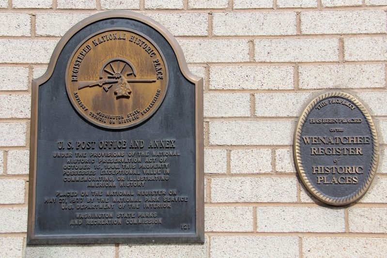
The first federal building was built in 1917 at the corner of Yakima and Mission. It housed the post . . . — — Map (db m197130) HM
On E. Evergreen Boulevard, on the left when traveling east.
As part of a natural reorganization, the U.S. Army returned the headquarters of the Department of the Columbia from Portland, Oregon to Fort Vancouver in 1878. As a result, the Army funded construction of several new buildings on Officers Row, . . . — — Map (db m8959) HM
On Fort Vancouver Way at Anderson Street, on the right when traveling south on Fort Vancouver Way.
This Italianate-Revival style home was built in 1878 for General Oliver Otis Howard, Commanding General of the Department of the Columbia from 1874 until 1880.
This gracious home was considered ”the finest dwelling house north of the . . . — — Map (db m8572) HM
On Louisiana Street at 16th Avenue/Washington Way, on the right when traveling west on Louisiana Street.
This library was privately financed as a gift to the City of Longview by its founder, Robert A. Long. It was the second building constructed to face the Civic Center and designed in the Georgian Revival style. Listed on the National Register of . . . — — Map (db m197139) HM
On Park Street (U.S. 101) near Simpson Avenue (U.S. 101) when traveling south.
These sandstone blocks, hewn from a quarry in the Cascades, were hand-carved and incorporated into Aberdeen's historic 1909 Weatherwax High School.
When the school burned down in 2002, the stones were wisely pulled from the ashes, but without . . . — — Map (db m199021) HM
On K Street at 7th Street, on the right when traveling north on K Street.
John James, Hoquiam's first settler, recalled in his memoirs an encounter which aptly, albeit unknowingly, identifies him as Hoquiam's first “librarian:”
One evening Humptulips Pete (an Indian) was sitting by my fire. He asked me about . . . — — Map (db m197152) HM
On Water Street east of Madison Street, on the right when traveling east.
In 1891 architects Batwell & Patrick designed a multi-purpose civic structure to house administrative offices, council chamber, courtroom, fire hall and jail to serve the needs of a city of 20,000.
Port Townsend's city council still meets . . . — — Map (db m129357) HM
On Water Street near Polk Street, on the right when traveling west.
Begun in 1892 by Port Townsend pioneer Joseph A. Kuhn, this building represented the latest ideas of the time in architecture. Construction was directed by Jonas Guise, then the best known contractor in the area. Bricks came from the yards of . . . — — Map (db m91331) HM
Under the provisions of the National Historic Preservation Act of October 15, 1966, this property possesses exceptional value in commemorating, or illustrating American history Placed on the National Register on Sept. 29, 1970 — — Map (db m222603) HM
On Water Street at Madison Street, on the right when traveling west on Water Street.
[(Top plaque)] Under the provisions of the National
Historic Preservation Act of
October 15, 1966, this property
possesses exceptional value in
commemorating, or illustrating
American history.
Placed on the National Register on . . . — — Map (db m197156) HM
On Adams Street north of Clay Street, on the right when traveling north.
Starrett House Under the provisions of the National Historic Preservation Act of October 15, 1966, this property possesses exceptional value in commemorating, or illustrating American History Placed on the National Register on September 29, . . . — — Map (db m129376) HM
On Auburn Avenue at 3rd Street Northeast, on the right when traveling north on Auburn Avenue.
Built 1914
Designated a City of Auburn Landmark 1995
The development of this local public library building was part of a national movement spurred by the philanthropy of iron and steel magnate Andrew Carnegie. In 1911, the Auburn Library . . . — — Map (db m197164) HM
On Ballard Avenue Northwest at 20th Avenue NW, on the left when traveling north on Ballard Avenue Northwest.
Built by Ballard saloon entrepreneur Louis Anderson, this structure was originally home to Warren Brothers Drug Store. In 1912 Samuel and Lewis Barthelemy opened the well-known Ballard Hardware and successfully conducted business from here for . . . — — Map (db m181484) HM
On Ballard Avenue Northwest at 20th Avenue NW, on the left when traveling north on Ballard Avenue Northwest.
Considered one of the largest moving companies in the area, Ballard Livery and Transfer was established on Leary Avenue in 1904. Its office was moved to this location in 1907, when B.J. Cooney took over the business. A year later the Boyd Brothers . . . — — Map (db m181485) HM
On Ballard Avenue Northwest, on the right when traveling north.
The original owner was Louis Chopard, a partner in Chopard and Cosgrove Wholesale and Retail Liquors, who ran his successful business in downtown Seattle. In 1901 Nicholas Theisen purchased this property and maintained ownership until the late . . . — — Map (db m181441) HM
On Ballard Avenue Northwest north of 22nd Avenue Northwest, on the right when traveling north.
Built for Fitzgerald and Hynes Department Store for a total of $15,000, this building was dedicated in February of 1909. The department store was located on the ground floor. The Ballard Aerie of Eagles leased the entire upper floor for what was . . . — — Map (db m181473) HM
On Ballard Avenue Northwest, on the right when traveling north.
In 1898 Swedish merchant tailors Frank and Arthur Enquist opened their first tailor shop down the street in the Swanson Block at 5140 Ballard Avenue. Through their success at that location, they were able to build this classic brick structure in . . . — — Map (db m181474) HM
On Ballard Avenue Northwest, on the left when traveling north.
Stephen Battleson, secretary and treasurer for the Horse Shoe Mining Company, with his sisters Olga and Emma, constructed a modest storefront here in 1905. It was initially occupied by Dr. A. J. Douglas's optical manufacturing business and P. . . . — — Map (db m181482) HM
On Ballard Avenue Northwest, on the left when traveling north.
Louis Anderson began his illustrious career in Ballard as a barber in 1891. He quickly became involved in the thriving saloon business, fronting bonds for various bar owners' liquor licenses. By 1902 he had opened his own saloon, the Fremont Saloon, . . . — — Map (db m181479) HM
On Ballard Avenue Northwest, on the left when traveling north.
This fine example of Romanesque architecture was built in 1901 and named in honor of Gustavus B. Sanborn, a pioneer Ballard businessman. Sanborn began his career as a carpenter in 1891. He owned a series of hardware stores on Ballard Avenue in the . . . — — Map (db m181481) HM
On Ballard Avenue Northwest at NW Market Street, on the left when traveling north on Ballard Avenue Northwest.
In 1920 Charles and Edna Halverson built this structure to house their Ladies and Gents Furnishings Store, which they ran successfully for thirty-four years. Shortly after opening the store they expanded their retail focus to include dry goods. . . . — — Map (db m181476) HM
On NW Dock Place at Ballard Avenue NW on NW Dock Place.
Built by Swan Hansen, the president of the Horse Shoe Mining Company, this elegant brick structure was home to the Henry Brothers Saloon (Charles and Lewis). By 1908 the Pederson and Olsen Bar took up residence on the ground floor and stayed until . . . — — Map (db m181487) HM
On Ballard Avenue Northwest at 20th Avenue NW, on the right when traveling north on Ballard Avenue Northwest.
Built by Seattle saloon owner Stephano Raggio in 1904, the Junction Building originally stood three stories tall with a crenellated turret. Unfortunately, fire destroyed the third floor, requiring its removal. In the early 1900s the ground floor was . . . — — Map (db m181465) HM
On Ballard Avenue Northwest north of NW Vernon Place, on the right when traveling north.
Brothers Charles and Richard Kutzner built this stately brick and sandstone structure in 1904 to house their Tonsorial Parlor, a successful barber shop that was formerly located in downtown Seattle. The Kutzners operated their business out of the . . . — — Map (db m181471) HM
On Ballard Avenue Northwest at NW Vernon Place, on the right when traveling north on Ballard Avenue Northwest.
Originally only two stories tall, this Neoclassical Revival building was financed by Albin and Oscar Matthes, proprietors of the Old Home Saloon. In 1905 the Fraternal Brotherhood of the Elks purchased the building and occupied the upper floor. The . . . — — Map (db m181466) HM
On Ballard Avenue Northwest at 22nd Avenue Northwest, on the right when traveling north on Ballard Avenue Northwest.
Tacoma residents James and Welthia Kelsey built this one-story building in 1903 as an investment. They entered into an agreement with Eugene Felt, the owner of the Felt Block next door, to create an internal opening between their two buildings . . . — — Map (db m181472) HM
On Ballard Avenue NW at NW Dock Place, on the right when traveling north on Ballard Avenue NW.
Alfred Palmer, proprietor of Alfred Palmer and Sons Real Estate Company in downtown Seattle, owned this building for more than three decades. Valued at $3,890 in 1905, the property was one of the more impressive structures in what was known as the . . . — — Map (db m181440) HM
Near Ballard Avenue Northwest south of NW Market Street, on the left when traveling north.
Built by prosperous Norwegian miner Martin Markusen, this vernacular sandstone and brick building first housed the St. Paul Hotel and later the Princess Hotel on its upper floor. Groceries and meat markets occupied the ground floor storefronts . . . — — Map (db m181478) HM
On NW Vernon Place at Ballard Avenue NW, on the right when traveling west on NW Vernon Place.
For over two decades the Ballard branch of the Scandinavian-American Bank operated out of this Second Empire Baroque structure, which was built in 1902. Originally incorporated in 1892, the bank's main branch was located in Seattle and boasted of a . . . — — Map (db m181468) HM
On 20th Avenue NW at Leary Avenue NW, on the right when traveling north on 20th Avenue NW.
In 1891 William Curtiss built a modest structure on this site to house his tinware and stove manufacturing and sales business. By 1909 he had expanded his inventory to include a wide variety of hardware products and in 1911 he constructed the . . . — — Map (db m181464) HM
On Ballard Avenue Northwest north of NW Ione Place, on the right when traveling north.
In 1901 Nicholas Theisen started his liquor store in the adjacent Chopard Block. Known as the California Wine Company, it featured "a high grade of California wine." Through the success of his business Mr. Theisen was able to construct the Theisen . . . — — Map (db m181442) HM
On Ballard Avenue Northwest south of NW Vernon Place, on the left when traveling north.
Prior to the construction of this classic building, this site housed a much more modest structure that contained the White Front Saloon. Proprietors John Peterson and Hector Chestnut ran their bar here from 1900 to 1905. When the current structure . . . — — Map (db m181483) HM
On Rainier Avenue South north of South Holden Street, on the right when traveling north.
A Trolley Stop along the Seattle and Rainier Valley Railway
Wildwood Station dates back to Washington State's early yeans when the first privately owned electric trolley rail service carried passenger streetcars and freight trains along . . . — — Map (db m181541) HM
On East Yesler Way at 23rd Avenue, on the left when traveling east on East Yesler Way.
Built by the people of Seattle, this structure was originally dedicated as the Henry L. Yesler Memorial Public Library. Over the course of the 20th century it served a diverse and changing community. In 1975, to reflect these changes and honor . . . — — Map (db m181534) HM
On 9th Avenue south of Cherry Street, on the right when traveling south.
Under the provisions of the National
Historic Preservation Act of
October 15, 1966, this property
possesses exceptional value in
commemorating, or illustrating
American history
Placed on the National Register on
March 16, 1972 by . . . — — Map (db m181530) HM
On 1st Avenue north of Bell Street, on the right when traveling north.
Dedicated: 1893
Elmer Fisher, architect
National Historic Register
Renovation & addition dedicated 1999
Snell Partnership, Architect
Cassimar US, Inc. & Austin A. Bell Associates, LLC
a member of the Murray Franklyn family . . . — — Map (db m181425) HM
Designed in 1901 by Max Umbrecht
For Clifford Beebe, This Building Although
Presenting an Elegant Neo-Regency Facade,
Housed a Modest Hostelry for Most of its
Earlier Life. It was Restored to In-City
Housing by the Cornerstone . . . — — Map (db m120352) HM
Only the base of this building, designed by the well-known firm of Bebb and Gould, in 1915 was designated. In 1982 the Bumgardner Partnership saved the facade and merged it into the new tower for the Cornerstone Development Corporation. — — Map (db m99636) HM
Opened in May 1930, the Exchange Building was designed to house more stock and mercantile exchanges than any building in the United States. It was constructed as one of the tallest and largest reinforced concrete structures in the world. . . . — — Map (db m99501) HM
On 1st Avenue at Lenora Street, on the right when traveling south on 1st Avenue.
Registered national
historic place
Washington State Advisory Council
on Historic Preservation
Guiry/Schillestad Buildings
under the provisions of the
National Historic Preservation
Act of 1966, this property possesses . . . — — Map (db m181422) HM
On South King Street at 5th Avenue S on South King Street.
Seattle has had three Chinatowns since the 1860s. The
present, third Chinatown was established in the early 1900s. This gate, or
Pai-Lau, marks the western entrance to Seattle's Chinatown.
For many years, the Seattle Chinese community . . . — — Map (db m142220) HM
On Spring Street east of Terry Avenue, on the right when traveling east.
Built 1931
Designated October 7, 2009
as a
City of Seattle
Historic Landmark
Designed by:
James H. Shack
Shack, Young & Myers Architects — — Map (db m181516) HM
On Pine Street at 9th Avenue, on the right when traveling east on Pine Street.
Listed in the National Register of
Historic Places by the
National Park Service,
U.S. Department of the Interior
October 9, 1974 — — Map (db m181515) HM
On 8th Avenue at James Street, on the right when traveling south on 8th Avenue.
Fire destroyed the interior of the church in 1902. It was rebuilt in its present form with enlarged transepts, sanctuary, and addition of a tower. The eclectic design is derived from English Country Gothic. The church has long been an important . . . — — Map (db m181532) HM
On Franklin Avenue East at East Shelby Street, on the left when traveling north on Franklin Avenue East.
Named as a French-Spanish twist on the word "lover", L'Amourita was built in 1909 by developer Adolph J. Jarmouth. It is a classic example of the Mission Revival style of architecture, with ornamentation unique to the Pacific Northwest. An Eastlake . . . — — Map (db m181512) HM
On Roosevelt Way Northeast at Northeast 50th Street, on the right when traveling south on Roosevelt Way Northeast.
The University Library,
a Carnegie Library listed on the
National Register of Historic Places,
was dedicated August 6, 1910.
Major renovation was completed in 1987
by the Seattle Public Library
through citizen support of the
Seattle . . . — — Map (db m197166) HM
Near 2nd Avenue north of Yester Way, on the right when traveling north.
Seattle’s first skyscraper opened on July 4, 1914. The 42 story Smith Tower was the tallest building outside of New York City and Seattle’s tallest for nearly fifty years. It was built by Lyman Smith of Smith-Corona and Smith and Wesson fame, from . . . — — Map (db m22481) HM
On 1st Avenue South at Railroad Way South (Washington Route 519), on the right when traveling south on 1st Avenue South.
Under the provisions of the National
Historical Preservation Act of
October 15, 1966, this property
possesses exceptional value in
commemorating or illustrating
American history
Placed on the National Register on
May 12, 1976 by . . . — — Map (db m181414) HM
On Yale Avenue North at Republican Street, on the right when traveling south on Yale Avenue North.
c. 1906
This property
has been placed on the
National Register
of Historic Places
by the United States
Department of the Interior — — Map (db m181513) HM
On Alki Avenue SW at 63rd Avenue SW, on the right when traveling east on Alki Avenue SW.
Near this site
in the autumn of 1851
David Denny and Lee Terry
erected first log cabin at Alki
Birthplace of Seattle
This plaque placed April 21, 1962
by the West Seattle
Rotary Club — — Map (db m181255) HM
Near Stevens Pass Highway (U.S. 2) at Old Cascade Highway, on the right when traveling west.
The twin tunnels were built in 1916 by blasting through solid granite rock. To protect the trains from falling pieces of granite, which is easily cracked by temperature extremes of freezing and thawing, a timber lining was constructed inside the . . . — — Map (db m156145) HM
On South 5th Avenue south of West Railroad Avenue, on the right when traveling north.
The building was constructed in 1914 and is an L-shaped Georgian Revival style building. The building embodies distinctive architectural characteristics of a design by Fredrick Heath who became one of Washington States most prominent architects . . . — — Map (db m116828) HM
On Duryea Street at 5th Street, on the right when traveling west on Duryea Street.
Registered National
Historic Place
Washington State Advisory Council
on Historic Preservation
Raymond Public Library
Under the provisions of the
National Historic Preservation
Act of 1966, this property possesses
exceptional . . . — — Map (db m197148) HM
Advertised as a place "where the flowers and the glaciers meet,” Paradise Inn opened on July 4, 1917. Here tourists arrived wearing long skirts and woolen traveling suits, "seeking a renewal of spirit in the vast world out-of-doors.”
Today, . . . — — Map (db m129378) HM
On Commerce Street at South 7th Street, on the right when traveling north on Commerce Street.
Under the provisions of the National
Historic Preservation Act of
October 16, 1966, this property
possesses exceptional value in
commemorating or illustrating
American history
Placed on the National Register on
May 17, 1974 by the . . . — — Map (db m197160) HM
On Main Street at Baker Drive, on the right when traveling west on Main Street.
The large number of buildings constructed from fireproof Portland cement distinguishes Concrete's downtown. It was reconstructed after two disastrous fires in 1915 and 1921 destroyed or damaged many of the original wooden buildings. As you look . . . — — Map (db m116620) HM
On 5th Avenue North north of Main Street, on the right when traveling north.
Constructed with a $5000 gift from industrialist Andrew Carnegie, this building opened as a free public library in 1911. Until 1962 it housed the library upstairs and the Edmonds City Hall downstairs. After other civic uses, it became the home of . . . — — Map (db m197169) HM
On Oakes Avenue, on the right when traveling north.
Everett Carnegie Library's design is based on the Pomona Carnegie Library, which was itself based largely on a scaled-down Boston Public Library, designed by the esteemed firm of McKim, Mead and White Architects. built in 1895, the Boston Public . . . — — Map (db m235826) HM
On Rockefeller Avenue, on the left when traveling north.
The first Presbyterian Church of Everett meets here. It was established in February 1892.
In 1897 the wood frame steepled church was moved from Maple Street between Hewitt and Pacific to this location on the corner of Rockefeller and Wall. The . . . — — Map (db m235780) HM
On 1st Street at Union Avenue, on the right when traveling east on 1st Street.
This award was presented to Zouhair Mardini and Mosaic Architecture for their demonstrated dedication to the true preservation and restoration of the historic features of the 901 First Street Building, ensuring that the additions were . . . — — Map (db m179010) HM
On 5th Street west of Avenue D, on the right when traveling west.
This corner stone and bell were
salvaged from the First Snohomish
Court House constructed in 1891.
The Snohomish School District
purchased the building in 1906
to be used as the school house. It
was removed in 1938 so that the . . . — — Map (db m179013) HM
Near North Division Street (U.S. 395) (U.S. 2) at East Olive Avenue, on the left when traveling north.
The Spokane River falls — despite their beauty and power that attracted the first Euro-American settlers to the region — was an obstacle to the new city. Private donations helped build the first public crossing in 1881. By 1888, a . . . — — Map (db m148627) HM
On West Spokane Falls Boulevard at North Post Road, on the right when traveling west on West Spokane Falls Boulevard.
The city of Spokane Falls was incorporated by the Territorial Legislature of Washington on November 29, 1881. On this site, Frederick Post, the City’s first miller, built a two-story house. His flour mill was situated at the edge of the river. . . . — — Map (db m148400) HM
On West Broadway Avenue just west of North Madison Street, on the right when traveling west.
The Spokane County Courthouse, designed by Willis A. Ritchie, is a magnificent example of the French Renaissance style of architecture. Note the intricate carving around the entry; the variety of construction materials; the many towers. Another . . . — — Map (db m154288) HM
On West Spokane Falls Boulevard west of North Lincoln Street, on the right when traveling west.
An Icon Began to Crumble For over a century the Monroe Street Bridge has symbolized Spokane's proud heritage. However by the turn of the 21st century increasing traffic, heavier loads, and decades of wind and weather had weakened the structure. . . . — — Map (db m148643) HM
On North Post Street north of West Spokane Falls Boulevard, on the left when traveling north.
Avista's Post Street Substation has distributed power to downtown Spokane since 1909. The substation, still identified by the Washington Water Power signs on its roof (the company changed its name in 1999), is a prominent part of Avista's living . . . — — Map (db m197103) HM
On West Spokane Falls Boulevard west of North Lincoln Street, on the right when traveling west.
• Total length: 965 feet • Central arch span: 281 feet • Side arch spans: 120 feet • Height (at railing): 136 feet • Cost: $535,000 (half went to labor) Completed in 1911, the grand triple-arched Monroe Street Bridge stands as a symbol of the . . . — — Map (db m148642) HM
On West Spokane Falls Boulevard west of North Lincoln Street, on the right when traveling west.
The growth of the city is traced in the growth of its bridges —E.T. Coman, president of the Spokane Chamber of Commerce, at the dedication of the Monroe Street Bridge in 1911. Spokane is a city of bridges. With thriving commerce . . . — — Map (db m148673) HM
AS YOU ENTER BUDD INLET...
The Dofflemyer Point Lighthouse greets you. It sits seven miles
north of the Port of Olympia, near the Boston Harbor Marina.
This structure provides the southernmost light in Puget Sound.
‘A JOYFUL NOISE’ - The . . . — — Map (db m234058) HM
Near 12th Avenue SW / Water Street SW at Cherry Lane SW, on the right when traveling west.
On August 3, 1911, the Washington State Capitol Commission awarded first prize in a design competition for our state's new capitol to New York architects Walter R. Wilder and Harry K. White. Wilder and White were relatively unknown, young . . . — — Map (db m128611) HM
Near Old Highway 12 near U.S. 12, on the left when traveling east.
The Prince's cabin displays prominent characteristics of homes French-Canadian/Métis design in the 1830s.
These features include the cabin's size (16' x 24'), original hinges, door (Fig. 1), and interior paint color, as well as the design . . . — — Map (db m158833) HM
On North Front Street north of East Yakima Avenue, on the left when traveling north.
The Old North Yakima Historic District was created and placed on the National Register on May 2, 1986, by the National Park Service, U.S. Department of Interior.
The Burlington Northern Freight Depot (Northern Pacific Company and Freight Depot) . . . — — Map (db m129400) HM
On North Front Street south of Pendleton Way, on the right when traveling south.
The Old North Yakima Historic District was created and placed on the National Register on May 2, 1986, by the National Park Service, U.S. Department of Interior.
The Burlington Northern Passenger Depot (Northern Pacific Railroad Passenger Depot) . . . — — Map (db m129403) HM